Images of Old Hawaiʻi

  • Home
  • About
  • Categories
    • Ali’i / Chiefs / Governance
    • American Protestant Mission
    • Buildings
    • Collections
    • Economy
    • Missionaries / Churches / Religious Buildings
    • General
    • Hawaiian Traditions
    • Other Summaries
    • Mayflower Summaries
    • Mayflower Full Summaries
    • Military
    • Place Names
    • Prominent People
    • Schools
    • Sailing, Shipping & Shipwrecks
    • Voyage of the Thaddeus
  • Collections
  • Contact
  • Follow

April 11, 2015 by Peter T Young Leave a Comment

Benjamin Douglas Baldwin

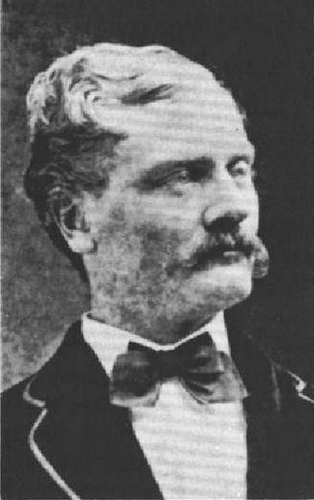
Benjamin Douglas Baldwin (grandson of the Rev Dwight Baldwin) was born at Kohala, Hawaii, April 12, 1868, son of David D and Lois M Baldwin. He attended Fort Street School and Oʻahu College (Punahou.)

He married Louise Theresa Voss in Honolulu on April 11, 1893; they had three sons, Douglas Elmer, Paul Frederick and Cedric Benjamin. (Nellist)

Baldwin began his career in the sugar cane industry on Haiku Sugar Co plantation, Hamakuapoko, Maui, on January 1, 1889.

Then, “Mr Benjamin D Baldwin, head luna of Hamakuapoko plantation has accepted the position of assistant manager of the Hawaiian Commercial Company, thus filling the vacancy caused by the death of Mr. David Center.”

“Mr. Baldwin and family will remove to Spreckelsville during the first part of April upon the return of Manager HA Baldwin from California.” (Pacific Commercial Advertiser, March 26, 1901)

Then on January 15, 1903, he  headed to Kauai. “Benjamin D Baldwin, formerly assistant manager of Puʻunene, is now permanently settled as manager of Makaweli plantation of Kauai. Mr and Mrs Baldwin will be much missed by Maui friends.” (Hawaiian Gazette, May 19, 1903)

“Makaweli is the banner plantation of Kauai since the Olokele ditch system enabled it to put a large additional area under cultivation.”

The Hawaiian Sugar Company, Ltd was headquartered at Makaweli, where the first cane was planted. The total land area was 7,000-acres held under lease from Gay & Robinson, extending from Waimea gulch to Hanapepe valley, a distance of several miles.

“The water supply for irrigation purposes is obtained from the Olokele and Hanapepe valley streams, the water flowing to all of the lands by gravity.”

“Work upon the Olokele ditch, which is the largest engineering scheme of the kind ever undertaken in the Islands, was begun for the Hawaiian Sugar Company by MM O’Shaughnessy and his assistants, Mr McLennan, HC Smalley and Guy P Rankin in 1902 and was completed in 1904.” (Evening Bulletin, March 25, 1909)

By the end of Baldwin’s management, in 1928, the annual yield increased to 27,057-tons of raw sugar and the company was noted as one of the most profitable and progressive in the Territory. (Faye)

“In the development of the property 2,250 skilled and unskilled laborers are employed who occupy several camps adjacent to their work. Better houses and better camps than are found on main plantations for the accommodation of men and their families have been erected.”

“The laborers receive in addition to their wages, which averages $20 per month, house room, fuel, water and medical attendance and have little patches of land where they raise vegetables.”

“The labor incident to the successful operation of this plantation is handled under two systems, one-third of the labor working under a or profit sharing system, and known as company men or contractors, the balance are day laborers, paid a regular rate per month of twenty-six working days.” (Evening Bulletin, March 25, 1909)

The Makaweli management takes much interest in the sports of the employes. A baseball diamond and land for tennis courts are provided. The Makaweli baseball team, by the way, secured the 1911 Kauai championship and in so doing gained three cups.”

“A club house for the skilled employes, which is equipped and supplied with reading matter and appliances, and a billiard and pool table, is supported by the company.” (Wright, Mid-Pacific Magazine, June 1914)

Baldwin died on April 27, 1928; a decade later, a substantial monument was erected by Makaweli Japanese sugar workers and dedicated to the memory of Baldwin, a highly respected plantation manager.

There are two circular metal medallions embedded in the column. The upper medallion has a bust of Baldwin surrounded by the words ‘Benjamin Douglas Baldwin 1867 – 1928,’ and the lower medallion has the words ‘Erected In Loving Memory by the Makaweli Japanese 1938.’ (Dorrance)

Baldwin was not just a sugar planter; he was commissioned as a major in the Hawaii National Guard (3rd Battalion, 4th Regiment) on Kauai and also commanded the Third Battalion of the Fifth Division during World War I. (Nellist) He was also postmaster at Makaweli.

A World War II ammunition magazine was located next to the monument (1942-1945.) Called ‘Battery Monument,’ it was armed with two old 7-inch/45 naval guns on pedestal mounts capable of hurling a 165-pound shell 16,500 yards (9.4 mi.) at 15° elevation. (Bennett)

Follow Peter T Young on Facebook 

Follow Peter T Young on Google+ 

Follow Peter T Young on LinkedIn  

Follow Peter T Young on Blogger

© 2015 Hoʻokuleana LLC

Ben D Baldwin-(EveningBulletin-1909)
Ben D Baldwin-(Men of Hawaii)
Benjamin Douglas Baldwin Monument-Faye
Managers Residence (Faye)
DE_Baldwin-(Faye)
DE_Baldwin-(Faye)
CB_Baldwin_and_Luna-(Faye)
CB_Baldwin-(Faye)
CB_Baldwin-(Faye)
Benjamin Douglas Baldwin Monument-Eleele
Benjamin Douglas Baldwin Monument-Dorrance; Bennett
USGS-Hanapepe-1963-portion-Baldwin Monument
USGS-Hanapepe-1996-portion-Baldwin Monument
Benjamin Douglas Baldwin grave marker

Filed Under: Prominent People, Economy Tagged With: Hawaii, Maui, Sugar, Kauai, Benjamin Douglas Baldwin, Makaweli

February 3, 2015 by Peter T Young Leave a Comment

Colonel Zephaniah Swift Spalding

“(He) was most emphatic in his conviction – the conviction of personal experience, that Sherman’s verdict, ‘War is Hell’ is the nearest thing to an adequate characterization of it that can happen.”

“‘In all reverence, War is hell – nothing else, and no effort to prevent war can be too assiduous or too costly.  The supreme effort of every people should be not to get out of war, but to keep out; – not to win a war, but to prevent it.’”  (Spalding, The Garden Island, June 1, 1920)

Colonel Zephaniah (Zeph) Swift Spalding fought in the US Civil War.  “The Colonel was in command of the famous Seventh New York Regiment, which was the second to reach Washington, even before the regular mobilization of the union troops. … “

“They found that Washington was practically a Southern city in sentiment and population – there were more Southerners than Union men there…”  (The Garden Island, June 1, 1920)

Spalding first enlisted in the 7th New York City Regiment. Within forty days, he had received a commission as a major in the 27th Ohio Regiment and held the rank of Lieutenant Colonel in that regiment at conclusion of that war.

It was reported that, because of his service record with the 27th Ohio during that war, he gained the favor and recommendation of Ohio Governor, David Todd, and, in 1867 was appointed by President Andrew Johnson to serve as American Consul to the Kingdom Hawaiʻi in Honolulu.

Spalding, born at Warren, Ohio, near Akron, September 2, 1837, was son of Rufus Paine Spalding – Representative and Speaker of the House of the Ohio Legislature, Justice of the Supreme Court of the State of Ohio and member of the US Congress.  Spalding was named after his father’s mentor, Zephaniah Swift, Chief Justice of Connecticut, whose daughter, Lucretia, was Zeph’s mother.

Shortly after the war, Zeph was tasked by Secretary of State William H Seward to serve as a ‘secret agent’ in Hawaiʻi (December 1867) to gauge “what effect the reciprocity treaty would have on future relations of the United States and Hawaiʻi.”  (They were weighing reciprocity versus annexation.)

His mission was said to have been known only to his father, Congressman RP Spalding, to Secretary Seward and to Senator Grimes of Iowa. His reports were made in the form of letters to his father, who delivered them to Seward.

Spalding was strongly opposed to the reciprocity treaty, and was in favor of annexation, which he thought would be hastened by rejection of the treaty. (Kuykendall)  That treaty, under consideration over 3-years (1867-1870) failed to pass.

On July 25, 1868 Andrew Johnson in a message to the US Senate nominated “Zephaniah S. Spalding, of Ohio, to be consul of the United States at Honolulu, in place of Morgan L. Smith, resigned.”  (US Senate Journal) He served as such until June 1, 1869, when President Ulysses S Grant suspended Spalding and nominated Thomas Adamson, Jr to replace him.

Soon after leaving the consulate in Honolulu, Spalding associated himself with Kamehameha V, Minister Hutchison and Captain James Makee in a sugar venture on the island of Maui.

Spalding’s association and work with the West Maui Sugar Association apparently caused a personal change of heart, transforming him into a strong supporter of reciprocity, and, in 1870, he wrote to President Grant suggesting …”

“… ‘to admit duty free Sugar’ and other articles from Hawaiʻi, in exchange that the Hawaiian Government grant or lease “sufficient land and water privileges upon the Island of Oahu near the port of Honolulu … to establish a Naval Depot”.  (Papers of Ulysses S Grant, September 27, 1870)

On July 18, 1871, Spalding married Wilhelmina Harris Makee, first-born daughter of Captain James Makee, at McKee’s Rose Ranch in Ulupalakua, Maui.  In that same year, Makee’s eldest son, Parker, took over management of the West Maui Sugar Association.

Zephaniah and Wilhelmina had five children: Catharine “Kitty” Lucretia Spalding; Rufus Paine Spalding; Julia “Dudu” Makee Spalding; Alice “Flibby” Makee Spalding and James “Jimmy” Makee Spalding.

The Treaty of Reciprocity finally passed in 1875, eliminating the major trade barrier to Hawai‘i’s closest and major market.  The US negotiated an amendment to the Treaty of Reciprocity in 1887 giving the US exclusive right to establish and maintain a coaling and repair station at Pearl Harbor.

In 1876, Captain Makee and Col. ZS Spalding purchased Ernest Krull’s cattle ranch in Kapaʻa, intending to start a sugar plantation and mill.  After a brief stay in San Francisco (1875-1878) Spalding returned to the Islands, living on Kauai. Where Makee was already operating the Makee Sugar Company and mill at Kapaʻa.

King Kalākaua and others formed a hui (partnership) to raise cane.  About the first of August, 1877, members of Hui Kawaihau moved to Kauai.  Makee had an agreement to grind their cane.

Upon Makee’s death in 1879, Spalding took over management of the new sugar venture.  Spalding also started the neighboring Keālia Sugar Plantation, in which King Kalākaua had a 25% interest. The Kapaʻa mill was closed in 1884, and all processing was done at Keālia. (In 1916, Colonel Spalding sold a majority of his holdings to the Līhuʻe Plantation Company, which kept the Keālia mill in operation until 1934, when it was dismantled and sent by rail to Lihue to become Mill “B”.)

 In the 1880s, Spalding built the “Valley House,” a Victorian-style wooden mansion, one of the finest on the island.

From 1877 to 1881, Hui Kawaihau was one of the leading entities on the eastern side of the Island of Kauaʻi, growing sugar at Kapahi, on the plateau lands above Kapaʻa.  (In 1916, Colonel Spalding sold his holdings to the Līhuʻe Plantation Company.)

On October 30, 1889, having traveled to Paris as the appointed representative of the Hawaiian Government, Spalding was presented the French order and ribbon of the Legion of Honor (Chevalier) during 1889 Universal Exposition in Paris.

Prior to the turn of the 19th century, Spalding had already developed a unique diffusion process for the refining of sugar at the Keālia Mill and was processing 24-hours a day. In 1900, with the construction of a new mill from Australia, sugar production was greatly increased.

Spalding expanded his business interests in Hawaiʻi, US and Europe.  In 1895, the idea of a Pacific communication cable caught his interest.

He formed the Pacific Cable Company of New Jersey and on August 12, 1895, he entered into agreement with the Republic of Hawaiʻi “to construct or land upon the shores of the Hawaiian group a submarine electric telegraph cable or cables to or from any point or points on the North American Continent or any island or islands contiguous thereto.”  (Congressional Record)

However, a rival company, Pacific Cable Company of New York formed to compete with him.  Congress split its support, the Senate favored Spalding and the House favored his rival.  In the end the two projects killed each other off.  (Pletcher)

“I tried to bring it about some years ago. We had a concession from the Hawaiian Government which we proposed to turn over to any company that might be formed under the auspices of the United States, but we could not get the aid of the United States in building the cable, and, of course, there was not enough business to attempt it without that.”  (Congressional Record)

(Ultimately, in 1902, the first submarine cable across the Pacific was completed (landing in Waikīkī at Sans Souci Beach; the first telegraph message carried on the system was sent from Hawaiʻi and received by President Teddy Roosevelt on January 2, 1903 (that day was declared “Cable Day in Hawaiʻi.”))

Spalding expanded his business interests in Hawaiʻi, US and Europe. During part of this time, Spalding moved his family to Europe to provide his children with a European education and Wilhelmina, “an accomplished musician,” who had suffered a debilitating stroke, with access to “concerts, opera and other musical events.” (Diffley)

In 1924, due to his failing health, Spalding left Kauai for California, to live with his son, James Makee Spalding, in the family home on Grand Avenue in Pasadena.  The last few years of his life were spent in California due to failing health, and he died in Pasadena on June 19, 1927 at the age of 89.

On the afternoon of April 20, 1930, a monument was dedicated to Col ZS Spalding, built by his Keālia Japanese friends. It is located at the corner of what was then known as Main Government Road and Valley House Road, a high point within the lands of the Makee Sugar Plantation. (Garden Island April 22, 1930)  (Lots of information also from Tyler.)

The image shows Zephaniah Swift Spalding.   In addition, I have included more related images in a folder of like name in the Photos section on my Facebook and Google+ pages.

Follow Peter T Young on Facebook 

Follow Peter T Young on Google+ 

Follow Peter T Young on LinkedIn   

© 2015 Hoʻokuleana LLC

Filed Under: Prominent People Tagged With: Rose Ranch, Zephaniah Swift Spalding, Hawaii, King Kalakaua, Kauai, James Makee, Kawaihau, Trans-Pacific Cable

September 3, 2014 by Peter T Young Leave a Comment

The Stitching

Since I started these summary posts, I have received a variety of questions and comments (from many) asking about this or that.

One such included a call from someone at Punahou School who had received the stitching noted in the image; someone saw it for sale in a store on the continent, bought it and gave it to Punahou.

They felt there were Punahou ties.  They asked me what I thought.

First, the center poem: “Friends are like melons; shall I tell you why? To find one good, you must one hundred try.”

I found it was written by Claude Mermet, a French poet who was born in Saint-Rambert-en-Bugey a little before 1550 and died in Saint-Rambert en Bugey in 1620.  (Obviously this is about friends and friendship, but no obvious Hawaiʻi tie … but is there?)
 
Then, the names … who is listed, who put this together and why was it done?

Some obvious Hawaiʻi ties come up – and lots of association back to Kauai with the likes of Rice, Wilcox and Isenberg … including their connections to Punahou.

It is still an untold story.

So, through this, hopefully more can be known of the Who, Why and When of the piece.  Let us know what you know about this.

It’s interesting … someone finds a piece of stitchery on the continent, sees connections to the Islands, but a mystery remains as to Who, Why and When ….

Here’s a summary and interconnecting linkages between the people noted on the stitchery we have seen thus far:

Wm H Rice
William Hyde Rice (born at Punahou,) son of William Harrison Rice (October 12, 1815-May 27, 1862) (business manager of Punahou School) and Mary Sophia Hyde Rice; husband of Mary Waterhouse Rice)

Mary W Rice
(Mary Waterhouse (July 26, 1846-June 28, 1933;) married William Hyde Rice; Punahou 1861 and 1862) John Thomas Waterhouse Sr., father of Mary.

Mary E Scott
(Mary Eleanor Rice (November 25, 1880-January 22, 1923;) daughter of William Hyde Rice and Mary Waterhouse Rice; married Walter Henry Scott

Anna C Wilcox
(Anna Charlotte Rice (1882- 😉 daughter of William Hyde Rice and Mary Waterhouse Rice; married Ralph Lyman Wilcox (son of Samuel Whitney Wilcox and Emma Washburn Lyman Wilcox))

Emily D Rice
(Emily Dole Rice (May 1844 – June 14, 1911;) daughter of William Harrison Rice (1813–1863), and Mary Sophia Hyde; married George De la Vergne) (Punahou 1863 and 1864)

R L Wilcox
(Ralph Lyman Wilcox (1876–1913;) son of Samuel Whitney Wilcox and Emma Washburn Lyman Wilcox;) married Anna Charlotte Rice)

Dora R Isenberg
(Mary Dorothea “Dora” Rice (1862-1949) Maria Rice, sister of William Hyde Rice married Paul Isenberg; Paul and Maria Isenberg had two children, Mary Dorothea Rice Isenberg and Daniel Paul Rice Isenberg (1866-1919).

Emma Wilcox
(Emma Washburn Lyman (September 16, 1849 – July 28, 1934;) daughter of David Belden Lyman (1803–1868) and Sarah Joiner (1806–1885;) married Samuel Whitney Wilcox) (her son, Ralph Lyman Wilcox, married Anna Charlotte Rice)

Susan S Fisher
Harry Fisher (1903-1905) (?)

Rebecca W Watt
Rebecca Waterhouse (?)
Rebecca Wilcox (?)
Rebecca Watt (1803-1915)

It’s ‘all in the family,’ kind of; and, it’s interesting how a piece of fabric can start to call attention to and remind us of stories about people and life in the Islands, especially on Kauai and at Punahou … but, there is still more to be known about the piece.

I have already done some posts on some of the people noted here, and will be doing some more in the future.  There is an obvious link to Punahou and Kauaʻi.

Any help others can provide on Who, Why and When (or anything more) this was done is appreciated.

The image shows the stitching.  In addition, I have added other images in a folder of like name in the Photos section on my Facebook and Google+ pages.

Follow Peter T Young on Facebook  

Follow Peter T Young on Google+    

Follow Peter T Young on LinkedIn   

© 2014 Hoʻokuleana LLC

Filed Under: Missionaries / Churches / Religious Buildings, Schools Tagged With: Kauai, John Thomas Waterhouse, William Hyde Rice, David Lyman, Isenberg, Hawaii, Oahu, Punahou

August 25, 2014 by Peter T Young Leave a Comment

Kīlauea

 “A little farther on we entered groves of hala, through which we continued to ride for the rest of our journey. We turned from the road to see the falls of the Kāhili River.”

“Though not large they are beautiful. Here the river falls in a jet of foam over a precipice of about 40 feet into a broad clear basin below….”  (Alexander, 1849; (Kīlauea Stream is universally referred to as “Kāhili Stream;”) Cultural Surveys)

Pukui suggests “Kīlauea means “spewing, much spreading;” associated references relate to volcanic eruptions at the place of like name on the Island of Hawaiʻi – typically referring to the rising smoke clouds.

Wichman explains the name as referring to “spewing many vapors” and traces it rather generically to the streams of Kīlauea that flow between the Makaleha Mountains and the Kamo‘okoa Ridge. The name may have originally been in reference to Kīlauea Falls itself.  (Cultural Surveys)

The relatively large volume of water flowing over a relatively wide and high drop against the prevailing trade winds (blowing approximately straight up the lower stretch of the valley) can create a large volume of diffuse mist that may have inspired the name of the land.  (Cultural Surveys)

In the Māhele, all of Kīlauea ahupuaʻa was retained as government lands; apparently no claims were made by native tenants, although there were several in a low, wide terrace along the stream in the adjoining Kāhili ahupuaʻa.

In January 1863, the approximate 3,016-acres of the Kīlauea ahupuaʻa were purchased by a former American whaler named Charles Titcomb.  Titcomb already had land holdings at Kōloa and Hanalei.  He was cultivating silkworm, coffee, tobacco, sugarcane and cattle.

Adding other leased land, he and partners Captain John Ross and EP Adams formed the Kilauea Plantation (1863,) and by 1877 the started a sugar plantation, “one of the smallest plantations in the Hawaiian Islands operating its own sugar mill”.  (Cultural Surveys)

Hawaiʻi’s earliest history with railroads is often credited to Kīlauea Plantation, whose first system opened in 1881 on three miles of narrow-gauge track to haul sugar cane.  Princess Lydia Kamakaeha (Lili‘uokalani) drove in the first spikes for the railroad bed. The plantation infrastructure grew over the next twenty years.

“The transportation system consists of twelve and a half miles of permanent track, five miles of portable track, 200 cane cars, six sugar cars and four locomotives.”

“(Kīlauea) is situated three miles from the landing at Kāhili, with which it is connected by the railway system. Sugar is delivered to the steamers by means of a cable device at the rate of from 600 to 800-bags an hour.”  (San Francisco Chronicle, July 18, 1910) The town of Kīlauea originated as the center of the sugar plantation operation; Kīlauea Sugar Plantation closed in 1970.

The Kīlauea School was founded in 1882 as an ‘English School.’  Its 54-pupils were primarily workers’ children from Kīlauea Sugar Plantation.  As the Board of Education of the Kingdom of Hawaiʻi owned no land in the district, school was held in a Protestant Church and partly in an old building that belonged to the Board.

In 1894, the Board of Education of the Republic of Hawaiʻi was able to obtain a two-acre parcel of land from the plantation and a two-room school and teacher’s cottage were erected (it was situated near Kūhiō Highway and Kalihiwai Road.)

By 1920, the educational facilities were greatly strained as the school boasted 239-students and 7-teachers for grades one through eight.  At the end of 1921, Kauai County purchased the present school site and the new school opened September 11, 1922; it has been in use since that time.  (NPS)

By the 1890s, much of the old kalo-growing areas of this portion of Kaua‘i were now producing rice, farmed by Chinese immigrants. There were 55-acres of land in rice production in the Kīlauea-Kāhili area in 1892 and eventually a rice mill on Kīlauea Stream.

The mill is known to have been on the stream terrace east of Kīlauea Stream. Rice and vegetable cultivation was also noted along the banks of Kīlauea Stream, circa 1925.  (Cultural Surveys)

Built in 1913 as a navigational aid for commercial shipping, the Kīlauea Lighthouse was credited with saving lives, not only of countless sailors lost at sea, but of two fliers on a historic trans-Pacific flight.

When Lt Albert Hegenberger and Lt Lester Maitland were on the first trans-Pacific airplane flight in history (June 29, 1927,) they overshot their course to Oʻahu and became lost.

They heard a strange signal and interpreted it as a radio beacon originating in the Islands. They used the signal to calculate their exact position and made the necessary adjustments to put them on course, thus enabling them to land the ‘Bird of Paradise’ safely at Hickam Field on Oʻahu.  (NPS)

Kīlauea Point National Wildlife Refuge, surrounding the Lighthouse, was established in 1985 to preserve and enhance seabird nesting colonies and was expanded in 1988 to include Crater Hill and Mōkōlea Point.  The refuge is home to some of the largest populations of nesting seabirds in in the main Hawaiian Islands.

Nearby, Hawaiian Islands Land Trust (HILT) added to an existing preserved property to form the Kāhili Coastal Preserve.  The property provides public access to Kāhili Beach while safeguarding the shoreline ecosystem.  (HILT)

The image shows Kīlauea Falls, Kauaʻi.  In addition, I have added others similar images in a folder of like name in the Photos section on my Facebook and Google+ pages.

Follow Peter T Young on Facebook

Follow Peter T Young on Google+ 

Follow Peter T Young on LinkedIn   

© 2014 Hoʻokuleana LLC

Filed Under: General, Place Names, Prominent People Tagged With: Kauai, Kilauea Lighthouse, Charles Titcomb, Lester Maitland, Albert Hegenberger, Kilauea Plantation, Hawaii, Kilauea

February 12, 2014 by Peter T Young Leave a Comment

Kauai

Poetically the island is reportedly called, “Manōkalanipō”, or “Kauai a Manō” after the ancient chief who was largely responsible for elevating Kauai’s ancient society to sophisticated heights of advancement and productivity.  (NativeKauai)

Geologically, Kauai is the oldest of the main inhabited islands in the chain. It is also the northwestern-most island, with Oʻahu separated by the Kaʻieʻie Channel, which is about 70-miles long. In centuries past, Kauai’s isolation from the other islands kept it safe from outside invasion and unwarranted conflict.

Kauai was traditionally divided into 5 moku (districts) including: Koʻolau, Haleleʻa, Nā Pali, Kona and Puna. (Common district names that are universally used across of the Hawaiian archipelago include “Koʻolau” marking the windward sides of the islands; “Kona” – the leeward sides of the islands; and “Puna” – indicating regions where springs and fresh water abound.)

The whole of the northwest coast (Napali) show the remains of extensive agricultural work and a fairly extensive population; the Mana region had clusters of house sites in the dry valleys that cut through the cliffs. Nearly all the great river valleys are thoroughly terraced and show evidence of population.

The principal location of the house sites is on the shore line, especially near the mouths of the river valleys where the taro was growing; in the mountains are some house sites and small villages.

The principal cultivated products on Kauai were taro, sweet potatoes, yams and gourds among the vegetables, and banana, breadfruit, coconut palm and paper mulberry among the trees.  (Bennett)

Malo notes that the “cultivation of kula lands is quite different from that of irrigable lands. The farmer merely cleared of weeds as much land as he thought would suffice. If he was to plant taro (upland taro), he dug holes and enriched them with a mulch of kukui leaves, ashes or dirt, after which he planted the taro.”

“In some places they simply planted without mulch or fertilizer … If a field of potatoes was desired, the soil was raised into hills, in which the stems were planted; or the stems might merely be thrust into the ground anyhow, and the hilling done after the plants were grown.”

The boundaries of the five moku on Kauai were changed in the late-1800s to reflect the present day judicial land districts, Kawaihau, Hanalei, Waimea, Kōloa and Līhuʻe.

In 1877, Hanalei and Līhuʻe shared a common boundary.  Kawaihau was set apart by King Kalākaua, who gave that name to the property lying between the Wailua River and Moloaʻa Valley.  A bill was introduced into the legislature and the eastern end of Hanalei District was cut out and Kawaihau became the fifth district on the island of Kauai.

Though comprising only 547-square miles, Kauai is large enough to have figured at all times as a major influence on Hawaiian culture. Together with Niʻihau it forms a group which is considerably isolated from the other Hawaiian islands.  (Bennett)

Fornander notes, “the ruling families of Kauai were the highest tapu chiefs in the group is evident from the avidity with which chiefs and chiefesses of the other islands sought alliance with them. They were always considered as the purest of the “blue blood” of the Hawaiian aristocracy; … But of the exploits and transactions of most of the chiefs who ruled over Kauai during this period, there is little preserved to tell.”

He further notes that during the “nine generations from Laamaikahiki (about the 14th century – he reportedly came from Tahiti,) the island of Niihau bore about the same political relation to the mōʻi (king) of Kauai as the island of Lanai did to the mōʻi of Maui – independent at times, acknowledging his suzerainty at others. … Springing from and intimately connected with the Kauai chiefs, there was a community of interests and a political adhesion which, however strained at times by internal troubles, never made default as against external foe.”

Then things changed for Kauai and the rest of the Islands.  In the dawn hours of January 18, 1778, on his third expedition, British explorer Captain James Cook on the HMS Resolution and Captain Charles Clerke of the HMS Discovery first sighted what Cook named the Sandwich Islands (that were later named the Hawaiian Islands.)  He first landed at Waimea, Kauai.

“The height of the land within, the quantity of clouds which we saw, during the whole time we staid, hanging over it, and frequently on the other parts, seems to put it beyond all doubt, that there is a sufficient supply of water; and that there are some running streams which we did not see, especially in the deep valleys, at the entrance of which the villages commonly stand.”  (James Cook Journal)

“From the wooded part to the sea, the ground is covered with an excellent sort of grass, about two feet high, which grows sometimes in tufts, and though not very thick at the place where we were, seemed capable of being converted into plentiful crops of fine hay. But not even a shrub grows naturally on this extensive space.”  (James Cook Journal)

Throughout their stay the ships were plentifully supplied with fresh provisions which were paid for mainly with iron, much of it in the form of long iron daggers made by the ships’ blacksmiths on the pattern of the wooden pāhoa used by the Hawaiians.  The natives were permitted to watch the ships’ blacksmiths at work and from their observations gained information of practical value about the working of iron. (Kuykendall)

After a month’s stay, Cook got under sail again to resume his exploration of the Northern Pacific. Shortly after leaving Hawaiʻi Island, the foremast of the Resolution broke and the ships returned to Kealakekua Bay for repairs.  On February 14, 1779, at Kealakekua Bay, Cook and some of his men were killed.

At the time of Cook’s arrival, the Hawaiian Islands were divided into four kingdoms: (1) the island of Hawaiʻi under the rule of Kalaniʻōpuʻu, who also had possession of the Hāna district of east Maui; (2) Maui (except the Hāna district,) Molokai, Lanai and Kahoʻolawe, ruled by Kahekili; (3) Oʻahu, under the rule of Kahahana; and at (4) Kauai and Niʻihau, Kamakahelei was ruler.

Kamakahelei was the “queen of Kauai and Niʻihau, and her husband (Kāʻeokūlani (Kāʻeo)) was a younger brother to Kahekili, while she was related to the royal family of Hawaiʻi. Thus, it will be seen, the reigning families of the several islands of the group were all related to each other, as well by marriage as by blood. So had it been for many generations. But their wars with each other were none the less vindictive because of their kinship, or attended with less of barbarity in their hours of triumph.”  (Kalākaua)

Kaumuali‘i was the only son of Kamakahelei and Kāʻeo; he was born in 1778 at Holoholokū, a royal birthing heiau specifically designated for the birth of high ranking children.  Kaumuali‘i became ruling chief of Kauai upon the death of his parents.

In 1784, Kamehameha I began a war of conquest, and, by 1795, with his superior use of modern weapons and western advisors, he subdued all other chiefdoms, with the exception of Kauai.  King Kamehameha I launched his first invasion attempt on Kauai in April of 1796, having already conquered the other Hawaiian Islands, and having fought his last major battle at Nuʻuanu on O‘ahu in 1795.

Kauai’s opposing factions (Kaumuali‘i versus Keawe) were extremely vulnerable as they had been weakened by fighting each other (Keawe died and Kaumuali‘i was, ultimately, ruler of Kauai and Ni‘ihau.)  Kamehameha’s two attempts at invading Kauai were foiled (by storm and sickness.)

The island was never conquered; in the face of the threat of a further invasion, in 1810, at Pākākā on Oʻahu, negotiations between King Kaumuali‘i and Kamehameha I took place and Kaumualiʻi yielded to Kamehameha. The agreement marked the end of war and thoughts of war across the islands.

After King Kamehameha I died in 1819, Kaumuali‘i pledged his allegiance to Liholiho, Kamehameha’s son and successor.    Kaumuali‘i settled in Honolulu and became a husband of Kaʻahumanu, widow of Kamehameha I.

Hiram Bingham was on a preaching tour of the island of Kauai in 1824, shortly before King Kaumuali‘i died.  Kaumuali‘i had been living on Oahu for three years.  Bingham spoke to him just before coming to Kauai.

Bingham writes:
“We found Kaumuali‘i seated at his desk, writing a letter of business.  We were forcible and pleasantly struck with the dignity and gravity, courteousness, freedom and affection with which he rose and gave us his hand, his hearty aloha, and friendly parting smile, so much like a cultivated Christian brother.”

When the king died, Bingham said a gloom fell over Kauai.

Kaumuali‘i was buried at Waine‘e Church (Wai‘ola Church,) on Maui (he wanted to be buried near Keōpūolani, another of Kamehameha’s wives – mother of Liholiho (Kamehameha II) and Kauikeaouli (Kamehameha III.))  (King Kaumuali‘i’s granddaughter Kapiʻolani (1834–1899) married King Kalākaua.)

The image shows a map of the island of Kauai, noting moku (districts) and ahupuaʻa. I added a couple of other images in a folder of like name in the Photos section on my Facebook and Google+ pages.

Follow Peter T Young on Facebook  

Follow Peter T Young on Google+  

© 2014 Hoʻokuleana LLC

Filed Under: Ali'i / Chiefs / Governance, Place Names Tagged With: Captain Cook, Kamakahelei, Puna, Kaeo, Kamehameha, Kaumualii, Kauai, Koolau, Na Pali, Kaahumanu, Liholiho, Hawaii, Waiola, Kona, Wainee, Kapiolani, Keopuolani

  • « Previous Page
  • 1
  • …
  • 16
  • 17
  • 18
  • 19
  • Next Page »

Images of Old Hawaiʻi

People, places, and events in Hawaiʻi’s past come alive through text and media in “Images of Old Hawaiʻi.” These posts are informal historic summaries presented for personal, non-commercial, and educational purposes.

Info@Hookuleana.com

Connect with Us

  • Email
  • Facebook
  • LinkedIn
  • Twitter
  • YouTube

Recent Posts

  • It was a dark and stormy night …
  • Joseph Paul Mendonça
  • Near Abdication
  • Karsten Thot
  • Ice
  • The First Thanksgiving
  • Anuenue

Categories

  • Prominent People
  • Schools
  • Sailing, Shipping & Shipwrecks
  • Economy
  • Voyage of the Thaddeus
  • Mayflower Summaries
  • American Revolution
  • General
  • Ali'i / Chiefs / Governance
  • Buildings
  • Missionaries / Churches / Religious Buildings
  • Hawaiian Traditions
  • Military
  • Place Names

Tags

Albatross Al Capone Ane Keohokalole Archibald Campbell Bernice Pauahi Bishop Charles Reed Bishop Downtown Honolulu Eruption Founder's Day George Patton Great Wall of Kuakini Green Sea Turtle Hawaii Hawaii Island Hermes Hilo Holoikauaua Honolulu Isaac Davis James Robinson Kamae Kamaeokalani Kamanawa Kameeiamoku Kamehameha Schools Lalani Village Lava Flow Lelia Byrd Liliuokalani Mao Math Mauna Loa Midway Monk Seal Northwestern Hawaiian Islands Oahu Papahanaumokuakea Marine National Monument Pearl Pualani Mossman Queen Liliuokalani Thomas Jaggar Volcano Waikiki Wake Wisdom

Hoʻokuleana LLC

Hoʻokuleana LLC is a Planning and Consulting firm assisting property owners with Land Use Planning efforts, including Environmental Review, Entitlement Process, Permitting, Community Outreach, etc. We are uniquely positioned to assist you in a variety of needs.

Info@Hookuleana.com

Copyright © 2012-2024 Peter T Young, Hoʻokuleana LLC


Loading Comments...