Images of Old Hawaiʻi

  • Home
  • About
  • Categories
    • Ali’i / Chiefs / Governance
    • American Protestant Mission
    • Buildings
    • Collections
    • Economy
    • Missionaries / Churches / Religious Buildings
    • General
    • Hawaiian Traditions
    • Other Summaries
    • Mayflower Summaries
    • Mayflower Full Summaries
    • Military
    • Place Names
    • Prominent People
    • Schools
    • Sailing, Shipping & Shipwrecks
    • Voyage of the Thaddeus
  • Collections
  • Contact
  • Follow

December 12, 2022 by Peter T Young Leave a Comment

Kalauao

At the time of Cook’s arrival (1778,) the Hawaiian Islands were divided into four kingdoms: (1) the island of Hawaiʻi under the rule of Kalaniʻōpuʻu, who also had possession of the Hāna district of east Maui; (2) Maui (except the Hāna district,) Molokaʻi, Lānaʻi and Kahoʻolawe, ruled by Kahekili; (3) Oʻahu, under the rule of Kahahana; and at (4) Kauaʻi and Niʻihau, Kamakahelei was ruler.

“At that time Kahekili was plotting for the downfall of Kahahana and the seizure of Oahu and Molokai, and the queen of Kauai was disposed to assist him in these enterprises.”  (Kalākaua)  Kamakahelei was married to Kāʻeokūlani (Kāʻeo – younger brother of Kahekili.)  Kamakahelei and Kāʻeo had a son Kaumualiʻi (born in 1778 at Holoholokū.)

Kahekili and his eldest son and heir-apparent, Kalanikūpule, conquered Kahahana, adding Oʻahu under his control.  And, in the late-1780s into 1790, Kamehameha conquered the Island of Hawai‘i and was pursuing conquest of Maui and eventually sought to conquer the rest of the archipelago.

The rich resources of the region, the shoreline fishponds, the numerous springs, and the fertile lands along the streams made ‘Ewa a prize for competing chiefs. Battles were fought for and on ‘Ewa lands, sometimes from competing O‘ahu chiefs, and sometimes by invading chiefs from other islands.  (Cultural Surveys)

At the death of Kahekili in 1793, Kāʻeo became ruling chief of Maui, Molokaʻi and Lānaʻi.  Kalanikūpule was ruler of Oʻahu.  Homesick for his friends, Kāʻeo set out to return to Kauaʻi by way of Waialua and then to Waimea.  He learned of a conspiracy to kill him and by November, 1794, Kāʻeo and Kalanikūpule were ready to fight.  (Kamakau)

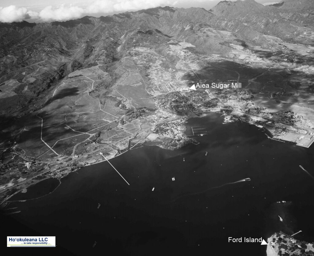
Kāʻeo was successful after some initial skirmishes.  On December 12, 1794, a great battle was fought in the area between Kalauao and ‘Aiea in ‘Ewa.  Kalanikūpule’s forces surrounded Kāʻeo.  (Cultural Surveys)

Kāʻeo with six of his men escaped into a ravine below ‘Aiea and might have disappeared there had not the red of his feather cloak been seen from the boats at sea and there shots drawn the attention of those on land. Hemmed in from above, he was killed fighting bravely.  (Kamakau)

This war, called Kukiʻiahu, was fought from November 16 to December 12, 1794 at Kalauao in ‘Ewa.  (Kamakau)  (It wasn’t long after that Kalanikūpule battled Kamehameha, again; and lost to Kamehameha at the Battle of Nuʻuanu.)

Kalauao Ahupua‘a (the multitude of clouds) extends from the East Loch of Pearl Harbor to the crest of the Koʻolau Range, generally following Kalauao Stream. Kalauao Spring is located near the Pearl Harbor coast.

The Kalauao Spring included two natural springs of percolating water.  In ancient times, the springs irrigated taro loʻi.  Later, the ancient taro lo‘i and ʻauwai (irrigation ditches) were modified and expanded to support rice cultivation.

In 1904, the area was described as, “On the morning of June 2nd, for instance, our destination was Aiea. At ten minutes past seven we boarded the first passenger train going towards Honolulu.”

“For a distance of eight miles the road skirts the shore and then turns landwards or mauka through rice and sugar plantations, Ewa Mill, Waipahu, Pearl City. …”

“Like all rice fields in Hawaii, this one is worked entirely by Chinamen, they alone being able to endure the conditions of location and climate necessary for the cultivation of this cereal.”

“On one side of the railroad track was the broad, muddy inland lake or bay of salt water, Pearl Harbor; on the other side were the terraced plots or fields, flooded to a depth of several inches with water and separated by narrow raised earthen ridges on which the careful Chinaman doubtless succeeded in walking, but which many times proved treacherous to our unsteady feet.”

“A rice plantation, laid out as it generally is on the low flats at the foot of a valley, where mountain streams empty into the sea, is an ideal collecting ground for certain kinds of algae.”  (Thrum 1904)

In 1928, Moriichi and Makiyo Sumida began farming assorted wetland produce on a two-acre plot of land at the springs.  Back then, the area of the springs contained many small farms growing similar produce — bananas, taro, rice, and watercress. Through the ensuing years, the Sumida property grew as they acquired neighboring leases and, by 1950, watercress became the sole crop.  (NPS)

A small waterfall along Kalauao Stream, named Kahuawai (or Kahuewai), was located along the coastal trail connecting Honolulu to Waiʻanae.  Kahuawai (water gourd container) was indicated to have been “a favorite resting place exclusively for chiefs”.  (Cultural Surveys)

Kahuawai was a noted bathing place since ancient times and was guarded so that any one did not bathe in it except the chiefs. Later it was used by all. Kākuhihewa’s daughters and the hero Kalelealuaka (their husband) bathed in this pool. Kāʻeokūlani, the chief of Kauaʻi also bathed here when he came to war here on Oʻahu.  (Cultural Surveys)

Loko Opu, a large fishpond (approximately 10.5-acres in size) located in Kalauao along the Pearl Harbor coast, is said to have been built by the chiefess Kalamanuʻia.  (Cultural Surveys)

During the Māhele, much of the lands in the ahupua‘a of ‘Ewa, as in other districts, were awarded to Ali‘i Nui (high chiefs), who were either the grandchildren or great-grandchildren of Kamehameha I.

Half of the ahupua‘a of Kalauao was awarded to Laura Konia (either granddaughter or grandniece of Kamehameha I;) the other half of Kalauao Ahupua‘a was awarded to John Meek, an important merchant in the sandalwood trade.

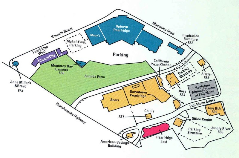
Today, the Pearl Country Club covers much of the lower section of Kalauao.   Pearlridge Shopping Center is on the lowest side of Kalauao (Pearlridge Uptown was opened in 1972, with an expansion in 1976 to include Pearlridge Downtown.)  Pearlridge surrounds the evidence of the water resources of old, Kalauao Spring that benefits the Sumida watercress farm.

© 2022 Hoʻokuleana LLC

Filed Under: Place Names Tagged With: Hawaii, Oahu, Kalanikupule, Ahupuaa, Kaeo, Ewa, Sumida Watercress, Kalauao, Pearlridge

August 5, 2022 by Peter T Young Leave a Comment

Placial vs Spatial

In modern land description, the context is ‘spatial’ – we tend to reference things by their location, area and use – 123 Main Street, 10,000-square feet, residential.

Look at any map, GPS orientation or recall how you describe a place, etc, it’s all about space and location; you learn where you are and the physical context of it.

In old Hawaiʻi, it was the nature of ‘place’ that shaped the practical, cultural and spiritual view of the Hawaiian people.

In Hawaiian culture, natural and cultural resources are one and the same.  Traditions describe the formation (literally the birth) of the Hawaiian Islands and the presence of life on, and around them, in the context of genealogical accounts.

All forms of the natural environment, from the skies and mountain peaks, to the watered valleys and lava plains, and to the shore line and ocean depths are believed to be embodiments of Hawaiian gods and deities.  (Maly)

“The ancients gave names to the natural features of the land according to their ideas of fitness. … There were many names used by the ancients to designate appropriately the varieties of rain peculiar to each part of the island coast; the people of each region naming the varieties of rain as they deemed fitting. … The ancients also had names for the different winds.”  (Malo)

Hawaiians named taro patches, rocks, trees, canoe landings, resting places in the forests and the tiniest spots where miraculous events are believed to have taken place.  (hawaii-edu)  There were names for everything, and multiple names for many.

Place names are often descriptive of: (1) the terrain, (2) an event in history, (3) the kind of resources a particular place was noted for or (4) the kind of land use which occurred in the area so named. Sometimes an earlier resident of a given land area was also commemorated by place names.  (Maly)

“Cultural Attachment” embodies the tangible and intangible values of a culture – how a people identify with, and personify the environment around them.

It is the intimate relationship (developed over generations of experiences) that people of a particular culture feel for the sites, features, phenomena and natural resources etc, that surround them – their sense of place. This attachment is deeply rooted in the beliefs, practices, cultural evolution and identity of a people.  (Kent)

In ancient Hawai‘i, most of the common people were farmers, a few were fishermen.  Access to resources was tied to residency and earned as a result of taking responsibility to steward the environment and supply the needs of aliʻi.  Tenants cultivated smaller crops for family consumption, to supply the needs of chiefs and provide tributes.

In this subsistence society, the family farming scale was far different from commercial-purpose agriculture.  In ancient time, when families farmed for themselves, they adapted; products were produced based on need.  The families were disbursed around the Islands.  An orderly delineation became needed.

Māʻilikūkahi is noted for clearly marking and reorganizing land division palena (boundaries) on O‘ahu.  Defined palena brought greater productivity to the lands; lessened conflict and was a means of settling disputes of future aliʻi who would be in control of the bounded lands; protected the commoners from the chiefs; and brought (for the most part) peace and prosperity.  (Beamer, Duarte)

Fornander writes, “He caused the island to be thoroughly surveyed, and boundaries between differing divisions and lands be definitely and permanently marked out, thus obviating future disputes between neighboring chiefs and landholders.”

Kamakau tells a similar story, “When the kingdom passed to Māʻilikūkahi, the land divisions were in a state of confusion; the ahupuaʻa, the ku, the ʻili ʻāina, the moʻo ʻāina, the pauku ʻāina, and the kihāpai were not clearly defined.”

“Therefore, Māʻilikūkahi ordered the chiefs, aliʻi, the lesser chiefs, kaukau aliʻi, the warrior chiefs, puʻali aliʻi, and the overseers (luna) to divide all of Oʻahu into moku, ahupuaʻa, ʻili kupono, ʻili ʻaina, and moʻo ʻāina.”

What is commonly referred to as the “ahupuaʻa system” is a result of the firm establishment of palena (boundaries.)  This system of land divisions and boundaries enabled a konohiki (land/resource manager) to know the limits and productivity of the resources that he managed.

Ahupuaʻa served as a means of managing people and taking care of the people who support them, as well as an easy form of collection of tributes by the chiefs.  Ultimately, this helped in preserving resources.

A typical ahupuaʻa (what we generally refer to as watersheds, today) was a long strip of land, narrow at its mountain summit top and becoming wider as it ran down a valley into the sea to the outer edge of the reef.  If there was no reef then the sea boundary would be about one and a half miles from the shore.

When the Hawaiians lived on the land as farmers and gatherers they became intimately acquainted with and named countless features and places.

Hawaiian customs and practices demonstrate the belief that all portions of the land and environment are related; the place names given to them tell us that areas are of cultural importance.  (Maly)

This Placial versus Spatial context reflects the relationship of the people to the land.

“Sense of place is about the feeling that emanates from a place as a combination of the physical environment and the social construct of people activity (or absence of) that produces the feeling of a place.  …  People seek out Hawaiʻi because of the expectation of what its sense of place will be when they get there.”  (Apo)

“Sense of place helps to define the relationships we have as hosts and guests, as well as how we treat one another and our surroundings.”  (Taum)

“In the Hawaiian mind, a sense-of-place was inseparably linked with self-identity and self-esteem.  To have roots in a place meant to have roots in the soil of permanence and continuity.”

“Almost every significant activity of his life was fixed to a place.”

“No genealogical chant was possible without the mention of personal geography; no myth could be conceived without reference to a place of some kind; no family could have any standing in the community unless it had a place; no place of significance, even the smallest, went without a name; and no history could have been made or preserved without reference, directly or indirectly, to a place.”

“So, place had enormous meaning for Hawaiians of old.”   (Kanahele)

© 2022 Hoʻokuleana LLC

Filed Under: Place Names Tagged With: Hawaii, Mailikukahi, Ahupuaa, Palena, Cultural Attachment

March 4, 2022 by Peter T Young Leave a Comment

Kīpapa Gulch

Place names help tell the stories of the place.

During the reign of Māʻilikūkahi, who ruled at about the same time Christopher Columbus crossed the Atlantic, invaders from Hawai‘i and Maui arrived on O‘ahu.

In the battles, the O‘ahu forces met the opposing forces in the uplands of Waipi‘o, and a great battle occurred.

Māʻilikūkahi was raised partly in Waialua and is said to have maintained a kulanakauhale (village) there.

Fornander writes, “He (Māʻilikūkahi) caused the island to be thoroughly surveyed, and boundaries between differing divisions and lands be definitely and permanently marked out, thus obviating future disputes between neighboring chiefs and landholders.”

Kamakau tells a similar story, “When the kingdom passed to Māʻilikūkahi, the land divisions were in a state of confusion; the ahupuaʻa, the ku, the ʻili ʻāina, the moʻo ʻāina, the pauku ʻāina, and the kihāpai were not clearly defined.”

“Therefore, Māʻilikūkahi ordered the chiefs, aliʻi, the lesser chiefs, kaukau aliʻi, the warrior chiefs, puʻali aliʻi, and the overseers (luna) to divide all of Oʻahu into moku, ahupuaʻa, ʻili kupono, ʻili ʻāina, and moʻo ʻāina.”

What is commonly referred to as the “ahupuaʻa system” is a result of the firm establishment of palena (boundaries.) This system of land divisions and boundaries enabled a konohiki (land/resource manager) to know the limits and productivity of the resources that they managed – and increase its productivity.

Māʻilikūkahi is also known for a benevolent reign that was followed by generations of peace. He prohibited the chiefs from plundering the makaʻāinana, with punishment of death. His reign “ushered in an era of benign rule lasting for several generations.”

Thrum notes that while Māʻilikūkahi was peacefully disposed, he proved to be a brave defender of his realm in thoroughly defeating the invading forces.

Fornander suggests it was not considered a war between the two islands, but, rather, it was a raid by some restless and turbulent chiefs. The invading force first landed at Waikīkī and proceeded to ʻEwa and marched inland.

At Waikakalaua (an upland ʻili of Waikele) they met Māʻilikūkahi and his forces, and a bloody battle ensued. The fight continued from there to the Kīpapa gulch – stretching across Kīpapa (an ʻili of Waipiʻo,) Waikakalaua and the place known as Punaluʻu.

Tradition has it that the body count from the invaders was so great that it is said the area was paved (kīpapa “placed prone”) with their bodies.

Punaluʻu, an upland ʻili, was named for one of the invading warrior-chiefs killed during the battle. Another warrior-chief, Hilo, was also killed in the battle.

Poʻohilo (an ʻili of Honouliuli) is named from events following a battle in the Kīpapa-Waikakalaua region in which the head of Hilo was placed on a stake at this site and displayed.

Kanupo‘o (an ʻili of Waikele) may be translated as meaning, “planted skull” and seems to imply an event of some importance – it may be tied to events of the battle at Kīpapa and the naming of Po‘ohilo at Honouliuli.

Today, people suggest the gulch is ruled by the spirits of fallen warriors; there are reports that this is one of the paths of the Huakaiʻpo (night marchers) and other reports suggest a woman dressed in white hitchhiking.

The area was also a temporary home to the Naval Air Station Kipapa Field / Kipapa Army Airfield. It was used because it could accommodate two 5,000′ runways free from obstructions (however, concerns were raised about increased air congestion due to its proximity between Pearl Harbor and Wheeler Field.)

The airfield site is located south the Mililani Golf Course between Meheula Parkway and Hokuala Streets – the runways extended out to the edge of the gulch. Mililani District Park is located near the intersection of the 2 main runways.

The use of this site by the Navy would permit the concentration of carrier-group training for Naval aviation on the south side of the island of Oahu including Barber’s Point, Kīpapa Gulch, and Ford Island.

But it was not until sometime after the United States entered World War II that Kipapa Airfield was developed; the exact start date is not clear, but 1943 maps note the facility.

During the war it apparently saw little use by the Navy due to the fact that carrier aircraft were constantly deployed during the war. The Army Air Corps became the principal user of the airfield by default.

Aircraft from this airfield searched & patrolled over the surrounding Pacific area, maintaining a 24-hour vigil to avert any attack with a large number and variety of squadrons are documented to have been stationed at Kipapa Airfield during World War II.

Kipapa Field was evidently closed at some point between 1959 and 1961 (it was no longer depicted on the 1961 and later mapping.)

© 2022 Hoʻokuleana LLC

Filed Under: Place Names Tagged With: Hawaii, Oahu, Mailikukahi, Ahupuaa, Ewa, Waikele, Kipapa, Night Marchers, Mililani, Huakaipo

February 12, 2022 by Peter T Young Leave a Comment

Kālaiʻāina

Early on, with the family unit being the socio-political structure, there was no need for a hierarchical or complex society.  However, as the population increased and wants and needs increased in variety and complexity, the need for chiefly rule became apparent.

Eventually, a highly stratified society evolved consisting of the Ali‘i (ruling class,) Kahuna (priestly and expert class of craftsmen, fishers and professionals) and Makaʻāinana (commoner class.)

The concept of private ownership of property did not exist in Hawaiʻi. The Kings were the sovereign owners of all of the land which was in turn controlled by the aliʻi nui or high chiefs and tended or farmed by the kanaka or commoners.  (RE3)

Laws and rules, called kapu, were created to prohibit abuse of resources, both to the land and ocean. The kapu prohibited certain practices in order to preserve scarce or limited resources. In this system everyone was entitled to a share of what was produced from the soil or taken from the sea.  (RE3)

Over the centuries, the Islands weren’t unified under single rule.  Leadership sometimes covered portions of an island, sometimes covered a whole island or groups of islands.  Island rulers, Aliʻi or Mōʻī, typically ascended to power through warfare and familial succession.

At the period of Captain Cook’s arrival (1778-1779), the Hawaiian Islands were divided into four kingdoms: (1) the island of Hawaiʻi under the rule of Kalaniʻōpuʻu, who also had possession of the Hāna district of east Maui; (2) Maui (except the Hāna district,) Molokaʻi, Lānaʻi and Kahoʻolawe, ruled by Kahekili; (3) Oʻahu, under the rule of Kahahana; and at (4) Kauaʻi and Niʻihau, Kamakahelei was ruler.

There were family connections of these four to Kamehameha; the death of Kiwalaʻo; the “Four Kona Uncles” (Keʻeaumoku, Keaweaheulu, Kameʻeiamoku and Kamanawa (the last two are twins and are depicted on the Hawaiian Coat of Arms;)) permission from Kalola to marry her granddaughter (after the defeat of Maui) and how Kamehameha secured his “unification” by “sharing the spoils” of the conquests and “braided the bloodlines;” eventually leading to the agreement with Kaumualiʻi.  (Yardley)

In Hawaiʻi, as in other parts of the world, control of the ʻāina has long been recognized as the basis for sovereignty. This was especially true in traditional Hawaiian society before Kamehameha united the islands.  At that time, the ultimate control of all ʻāina was vested in the mō’ī of each island, as he or she was the paramount Chief. (Kameʻeleihiwa)

Control of ʻāina is not the same as ownership of ʻāina, in the Western capitalist sense. In traditional Hawaiian society, ʻāina was given from one person to another, but was never bought or sold.

 If in Hawaiian metaphor, all ʻāina and products of the ʻāina – in fact life itself – proceed from the Akua, then “ownership” of the ʻāina and all wealth emanating from the ʻāina rightfully belong to those Akua from whom they proceed.  (Kameʻeleihiwa)

Kālaiʻāina (the carving/distribution of land) by the mōʻī was practiced not only upon conquest, but traditionally at the peaceful ascension of a new mōʻī.  (Klieger)

After selecting lands for himself, the King allotted the remaining to the warrior Chiefs who rendered assistance in his conquest.  These warrior Chiefs, after retaining a portion for themselves, reallotted the remaining lands to their followers and supporters.

However, no one owned the land and at death a parcel or unit was returned to the overseer for redistribution. Essentially, the king could distribute land to anyone he wanted if he so chose. (RE3)

The distribution of lands was all on a revocable basis.  What the superior gave, he was able to take away at his pleasure.  This ancient tenure was in nature feudal, although the tenants were not serfs tied to the soil – they were allowed to move freely from the land of one Chief to that of another.

A process for formal individual “ownership” of the land followed a transition over the years.  In 1839 the Bill of Rights of the Hawaiian Islands was enacted which guaranteed that people’s lands would not be taken from them.

In 1840, the first Constitution of Hawai`i was enacted. This constitution made it clear that people had an interest in land greater than that of the bounty and produce of the land.

In 1845, the Land Commission was created in Hawaiʻi by Kamehameha III to award land claims. Then, in 1848, the Māhele (land division) occurred with the King and 245 aliʻi and konohiki came together to divide the land.

Each māhele was in effect a quitclaim agreement between the King and a Chief or Konohiki with reference to the lands in which they both claimed interests.  For the lands set aside for the Chief or Konohiki, the King signed an agreement: “I hereby agree that this division is good.  The lands above written are for (name of Chief or Konohiki); consent is given to take it before the Board of Commissioners to Quiet Land Titles.”

The Māhele itself did not convey title to land. The high Chiefs and the lesser Konohiki were required to present their claims before the Land Commission to receive awards for the lands.  With an award, the person was still required to pay commutation to the government, in cash or by surrender of equally valuable lands (set at one third of the value of the unimproved land.)

In the Māhele of 1848, of the approximate 10,000 awards, around 1,000,000-acres were reserved by King Kamehameha III as “Crown” lands, 1,500,000-acres were given by the King (as “Government” lands) to the ‘government and people’, approximately 1,500,000-acres were set aside for the Chiefs (as “Konohiki” lands) and less than 30,000-acres of land were awarded to the native tenants (Kuleana lands.)

© 2022 Hoʻokuleana LLC

Filed Under: Hawaiian Traditions Tagged With: Hawaii, Great Mahele, Ahupuaa

March 26, 2020 by Peter T Young Leave a Comment

Ahupuaʻa ‘Anomalies’

Typically, we think of ahupuaʻa in the general context of the modern day watershed – from the mountains to the sea (ridges to reefs,) affording occupants access to the various climatic and resource zones.

Ahupuaʻa served as a means of managing people and taking care of the people who support them, as well as an easy form of collection of tributes by the chiefs. Ultimately, this helped in preserving resources.

Shaped by island geography, ahupuaʻa varied in shape and size (from as little as 100-acres to more than 100,000-acres.)

Each ahupuaʻa had its own name and boundary lines. Often the markers were natural features such as a large rock or a line of trees or even the home of a certain bird. A valley ahupuaʻa usually used its ridges and peaks as boundaries.

In ancient Hawaiian times, relatives and friends exchanged products. The upland dwellers brought poi, taro and other foods to the shore to give to kinsmen there. The shore dweller gave fish and other seafood. Visits were never made empty-handed but always with something from one’s home to give.

Ahupuaʻa contained nearly all the resources Hawaiians required for survival. Fresh water resources were managed carefully for drinking, bathing and irrigation.

A typical ahupuaʻa was a long strip of land, narrow at its mountain summit, becoming wider as it ran down a valley into the sea to the outer edge of the reef. If there was no reef, then the sea boundary would be one-mile from the shore.

However, there are several ‘anomalies’ to this conventional ahupuaʻa layout.

Some include multiple parts, even skipping over water. Others do not have contact with the ocean, nor reach a mountain peak. Another includes portions of a couple of mountains. Here are some examples (there are others, as well.)

On the island of Hawaiʻi, the ahupuaʻa of Kīʻao in the moku (district) of Kāʻu is land-locked and doesn’t reach the ocean. (Paman) In addition, it doesn’t reach a mountain summit.

Also on the Island of Hawaiʻi, the ahupuaʻa of Humuʻula starts at the summit of Mauna Loa, crosses the saddle between the two mountains and skirts along the side of Mauna Kea and eventually runs down to the ocean along the Hāmākua coast.

This traversing along a relatively similar contour on the side of Mauna Kea is unique; in addition, in doing so, it essentially cuts off the numerous ahupuaʻa along the South Hilo, North Hilo and Hāmākua coasts to the Mauna Kea summit.

Interestingly, the entire island of Kahoʻolawe is part of the Honuaʻula moku (district) across the ocean on Maui. Kahoʻolawe is not its own ahupuaʻa; rather, it is divided into ʻili (smaller land units within ahupua‘a.)

Historically, a “cloud bridge” connected Kahoʻolawe with the slopes of Haleakalā. The Naulu winds brought the Naulu rains that are associated with Kahoʻolawe (a heavy mist and shower of fine rain that would cover the island.)

Heʻeia on the windward side of Oʻahu runs from the mountains to the sea, but also crosses over a portion of the water in Kāneʻohe Bay and includes a portion of a Mōkapu peninsula across the Bay.

The Waiʻanae ahupuaʻa also has an un-typical shape – it is sometimes referred to in two parts: Waiʻanae Kai, on its western side, runs from the ocean to the Waiʻanae Mountains (like a typical ahupuaʻa – this portion of Waiʻanae runs from the mountain to the sea.)

From there, however, the section referred to as Waiʻanae Uka continues across Oʻahu’s central plain and extends up into the Koʻolau Mountains – extending approximately 15-miles from the Waianae Mountains to the Koʻolau Mountains and ends up overlooking the windward coastline. (Each section is within the same ahupuaʻa.)

Waimānalo is another Oʻahu ahupuaʻa that is ‘anomalous’ to the ‘ridges to reefs’ characterization of the ‘typical’ ahupuaʻa.

Waimānalo extends from the ridge behind Keolu Hills, around Makapuʻu and ending at Kuliʻouʻou Ridge (Koʻolaupoko Hawaiian Civic Club;) it essentially wraps over the Koʻolau range from the windward coast to the leeward coast Oʻahu.

Waimānalo incorporates what was once the large fishpond of Maunalua, now known as Hawaiʻi Kai. Kamakau notes, “The ahupuaʻa of Waimānalo, including the fishpond at Maunalua and the travelling uhu of Makapuʻu, belonged to Mauimua (First-Maui.)” (Koʻolaupoko Hawaiian Civic Club)

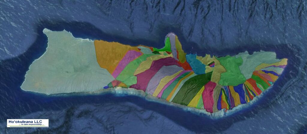
The image shows a map of the Islands with some of the anomalies to the typical’ ahupuaʻa.

Follow Peter T Young on Facebook 

Follow Peter T Young on Google+ 

Follow Peter T Young on LinkedIn  

Follow Peter T Young on Blogger

© 2020 Hoʻokuleana LLC

Statewide-Some_Ahupuaa_Anomalies-GoogleEarth
Hawaii-Humuula-Kiao-Ahupuaa-GoogleEarth
Hawaii-Humuula-Ahupuaa-GoogleEarth
Hawaii-Kiao-Ahupuaa-GoogleEarth
Maui-Honuaula-Moku-GoogleEarth
Oahu-Waianae-Heeia-Waimanalo-Ahupuaa-GoogleEarth
Oahu-Waianae-Ahupuaa-GoogleEarth
Oahu-Heeia-Ahupuaa-GoogleEarth
Oahu-Waimanalo-Ahupuaa-GoogleEarth
Typical_Ahupuaa_Layout_and_Land_Uses-(UH-DURP)

Filed Under: Hawaiian Traditions, Place Names Tagged With: Hawaii, Waimanalo, Koolau, Koolaupoko, Kahoolawe, Ahupuaa, Waianae, Honuaula, Humuula

  • 1
  • 2
  • 3
  • 4
  • Next Page »

Images of Old Hawaiʻi

People, places, and events in Hawaiʻi’s past come alive through text and media in “Images of Old Hawaiʻi.” These posts are informal historic summaries presented for personal, non-commercial, and educational purposes.

Info@Hookuleana.com

Connect with Us

  • Email
  • Facebook
  • LinkedIn
  • Twitter
  • YouTube

Recent Posts

  • April Fool
  • King of Handcuffs
  • Declaratory Act
  • Hui Panalāʻau
  • Arakawas
  • “Honolulu’s Tropical Jewel”
  • California Girl, Wenona

Categories

  • General
  • Ali'i / Chiefs / Governance
  • Buildings
  • Missionaries / Churches / Religious Buildings
  • Hawaiian Traditions
  • Military
  • Place Names
  • Prominent People
  • Schools
  • Sailing, Shipping & Shipwrecks
  • Economy
  • Voyage of the Thaddeus
  • Mayflower Summaries
  • American Revolution

Tags

$20000 Albatross Battery Salt Lake Carl Winstedt Code Talkers Collegia Theatre David Howard Hitchcock Department of Hawaiian Home Lands Diamond Head Four Minute Men Freeman H-4 Hailima Hale Halawai Hale O Lono Hawaiian Pineapple Day Hilo High School Hobbamock James Colnett James Hay Wodehouse James I John Oldham Kamanawa Kamehameha V Kona Field System Kukaniloko Kuleana Labor Day Lunalilo Home Mao Merchant Street Na Pali One Horse Open Sleigh Panic of 1819 Pedro Menendez Picture Bride President Lines Quilt Resolution Samuel Damon Scotch Coast Titian Ramsey Peale Upena Poepoe William Reed Yoshio Harada

Hoʻokuleana LLC

Hoʻokuleana LLC is a Planning and Consulting firm assisting property owners with Land Use Planning efforts, including Environmental Review, Entitlement Process, Permitting, Community Outreach, etc. We are uniquely positioned to assist you in a variety of needs.

Info@Hookuleana.com

Copyright © 2012-2021 Peter T Young, Hoʻokuleana LLC


Loading Comments...