Prior to European contact, each of the major islands or independent chiefdoms in the Hawaiian chain comprised a mokupuni (island.) Over the centuries, as the ancient Hawaiian population grew, land use and resource management also evolved.
The traditional land division of pre-contact Hawaiians was based on the sustainability and self-reliance within ahupuaʻa (community watershed areas) as well as within larger regions (moku) and lastly individual sovereign islands (mokupuni.)
The mokupuni were subdivided into land units of varying sizes, and the largest division was the moku (district – literally: interior island,) administered by high-ranking chiefs.
They were either relatives of the high chief of the island, trusted supporters or high ranking individuals who pledged their support to the high chief but were allowed to remain relatively independent.
Each island was divided into several moku or districts, of which there are six in the island of Hawaiʻi, and the same number in Oʻahu. There is a district called Kona on the lee side and one called Koʻolau on the windward side of almost every island. (Alexander)
It appears that the six districts on the islands of O‘ahu and Hawai‘i, and the system of developing smaller manageable units of land became formalized in the reigns of Māʻilikūkahi and ʻUmi-a-Līloa, respectively (about the time Columbus was sailing across the Atlantic.)
Māʻilikūkahi is noted for clearly marking and reorganizing land division palena (boundaries) on O‘ahu. Palena, or possibly an evolved term “palena ʻāina” are place boundaries. (Beamer)
Defined palena brought greater productivity to the lands; lessened conflict and was a means of settling disputes of future aliʻi who would be in control of the bounded lands; protected the commoners from the chiefs; and brought (for the most part) peace and prosperity.
Fornander writes, “He caused the island to be thoroughly surveyed, and boundaries between differing divisions and lands be definitely and permanently marked out, thus obviating future disputes between neighboring chiefs and landholders.”
Kamakau tells a similar story, “When the kingdom passed to Māʻilikūkahi, the land divisions were in a state of confusion; the ahupuaʻa, the ku, the ʻili ʻāina, the moʻo ʻāina, the pauku ʻāina, and the kihapai were not clearly defined.”
“Therefore, Māʻilikūkahi ordered the chiefs, aliʻi, the lesser chiefs, kaukau aliʻi, the warrior chiefs, puʻali aliʻi, and the overseers (luna) to divide all of Oʻahu into moku, ahupuaʻa, ʻili kupono, ʻili ʻāina, and moʻo ʻāina.”
Malo gives a detailed description of the kuleana that a kālaimoku aliʻi who divided lands for Mōʻī had to fulfill: “There are two important aspects in being a kālaimoku, to take care of the aliʻi, and to take care of the makaʻāinana, for these two reasons the kālaimoku guides the aliʻi at his side, with the careful attention to these two things, things were to be done properly.” (Malo, Beamer)
What is commonly referred to as the “ahupuaʻa system” is a result of the firm establishment of palena (boundaries.) This system of land divisions and boundaries enabled a konohiki (land/resource manager) to know the limits and productivity of the resources that they managed.
In the late-1400s, through warfare and alliances with other chiefs, ʻUmi gained control of the entire Island of Hawaiʻi. ʻUmi made himself the aliʻi nui, or high chief, for the whole island.
ʻUmi divided his island into separate moku, or districts. These moku were subdivided into smaller sections called ahupuaʻa.
In the time of ʻUmi, son of the great chief Līloa, the Hawaiian islands were divided into political regions. The four mokupuni (larger islands) of Kauai, Oʻahu, Maui, and Hawaiʻi were divided into moku (districts).
The smaller islands of Molokai, Lānai and Kahoʻolawe became moku of Maui, and Niʻihau a moku of Kauai.
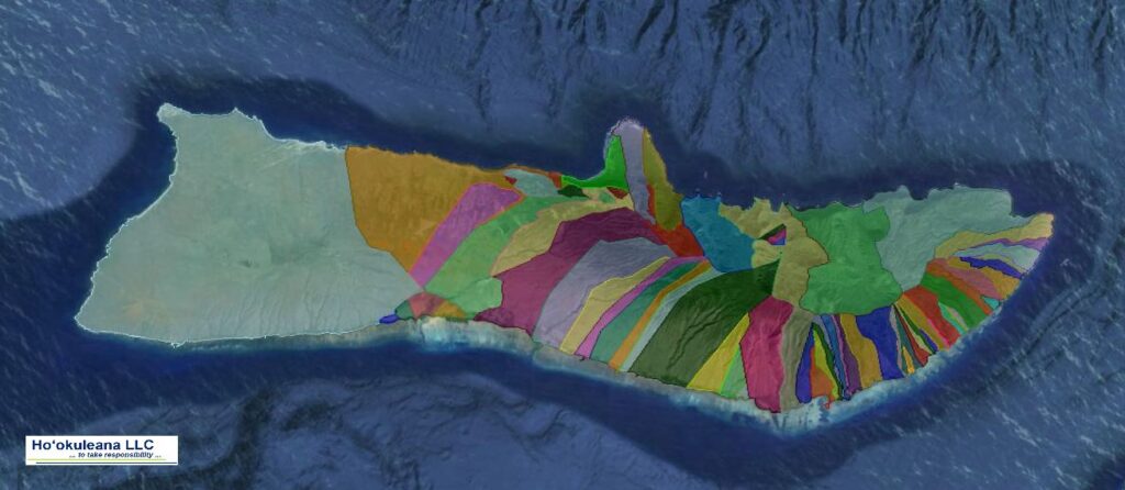
Traditionally, the Island of Kauai was divided into five moku (districts): Haleleʻa, Kona, Koʻolau, Nāpali and Puna. However, after the battle of Wahiawa in 1824, the land of Kauai was redistributed and district boundaries changed. The new district names became: Hanalei, Kawaihau, Līhuʻe, Kōloa and Waimea. (Cultural Surveys)
For ease in collecting annual tribute, the moku were subdivided into ahupuaʻa, land sections that usually extended from the mountain summits down through fertile valleys to the outer edge of the reef in the sea (or if there was not reef, one-mile from shore.)
The size of the ahupuaʻa depended on the resources of the area with poorer agricultural regions split into larger ahupuaʻa to compensate for the relative lack of natural abundance. Each ahupuaʻa was ruled by an aliʻi or local chief and administered by a konohiki.
These natural land divisions were the result of the flow of water over the land (streams or springs.)
From the earliest days, streams were among the most important natural resources sought after by native Hawaiians. Battles were fought and lives sacrificed for the right to use stream water.
The Hawaiians called freshwater wai, and considered it to be sacred. People using wai from streams took only what was absolutely necessary. They were expected to share the wai with others. This was done without greed or selfishness.
Such practices gave Hawaiians their word for law which is kanawai, or the “equal sharing of water.” Water was so valuable to Hawaiians that they used the word “wai” to indicate wealth. Thus to signify abundance and prosperity, Hawaiians would say waiwai.
In keeping with this concept of wealth being fresh water, the traditional land tenure system in ancient Hawaii had at its very core the presence of streams, or kahawai. Although of many shapes and sizes, each ahupua’a consisted of three area types: mountain, plain and sea.