Images of Old Hawaiʻi

  • Home
  • About
  • Categories
    • Ali’i / Chiefs / Governance
    • American Protestant Mission
    • Buildings
    • Collections
    • Economy
    • Missionaries / Churches / Religious Buildings
    • General
    • Hawaiian Traditions
    • Other Summaries
    • Mayflower Summaries
    • Mayflower Full Summaries
    • Military
    • Place Names
    • Prominent People
    • Schools
    • Sailing, Shipping & Shipwrecks
    • Voyage of the Thaddeus
  • Collections
  • Contact
  • Follow

July 20, 2026 by Peter T Young Leave a Comment

Moku

Prior to European contact, each of the major islands or independent chiefdoms in the Hawaiian chain comprised a mokupuni (island.) Over the centuries, as the ancient Hawaiian population grew, land use and resource management also evolved.

The traditional land division of pre-contact Hawaiians was based on the sustainability and self-reliance within ahupuaʻa (community watershed areas) as well as within larger regions (moku) and lastly individual sovereign islands (mokupuni.)

The mokupuni were subdivided into land units of varying sizes, and the largest division was the moku (district – literally: interior island,) administered by high-ranking chiefs.

They were either relatives of the high chief of the island, trusted supporters or high ranking individuals who pledged their support to the high chief but were allowed to remain relatively independent.

Each island was divided into several moku or districts, of which there are six in the island of Hawaiʻi, and the same number in Oʻahu. There is a district called Kona on the lee side and one called Koʻolau on the windward side of almost every island.  (Alexander)

It appears that the six districts on the islands of O‘ahu and Hawai‘i, and the system of developing smaller manageable units of land became formalized in the reigns of Māʻilikūkahi and ʻUmi-a-Līloa, respectively (about the time Columbus was sailing across the Atlantic.)

Māʻilikūkahi is noted for clearly marking and reorganizing land division palena (boundaries) on O‘ahu.  Palena, or possibly an evolved term “palena ʻāina” are place boundaries.  (Beamer)

Defined palena brought greater productivity to the lands; lessened conflict and was a means of settling disputes of future aliʻi who would be in control of the bounded lands; protected the commoners from the chiefs; and brought (for the most part) peace and prosperity.

Fornander writes, “He caused the island to be thoroughly surveyed, and boundaries between differing divisions and lands be definitely and permanently marked out, thus obviating future disputes between neighboring chiefs and landholders.”

Kamakau tells a similar story, “When the kingdom passed to Māʻilikūkahi, the land divisions were in a state of confusion; the ahupuaʻa, the ku, the ʻili ʻāina, the moʻo ʻāina, the pauku ʻāina, and the kihapai were not clearly defined.”

“Therefore, Māʻilikūkahi ordered the chiefs, aliʻi, the lesser chiefs, kaukau aliʻi, the warrior chiefs, puʻali aliʻi, and the overseers (luna) to divide all of Oʻahu into moku, ahupuaʻa, ʻili kupono, ʻili ʻāina, and moʻo ʻāina.”

Malo gives a detailed description of the kuleana that a kālaimoku aliʻi who divided lands for Mōʻī had to fulfill:  “There are two important aspects in being a kālaimoku, to take care of the aliʻi, and to take care of the makaʻāinana, for these two reasons the kālaimoku guides the aliʻi at his side, with the careful attention to these two things, things were to be done properly.”  (Malo, Beamer)

What is commonly referred to as the “ahupuaʻa system” is a result of the firm establishment of palena (boundaries.)  This system of land divisions and boundaries enabled a konohiki (land/resource manager) to know the limits and productivity of the resources that they managed.

In the late-1400s, through warfare and alliances with other chiefs, ʻUmi gained control of the entire Island of Hawaiʻi. ʻUmi made himself the aliʻi nui, or high chief, for the whole island.

ʻUmi divided his island into separate moku, or districts. These moku were subdivided into smaller sections called ahupuaʻa.

In the time of ʻUmi, son of the great chief Līloa, the Hawaiian islands were divided into political regions. The four mokupuni (larger islands) of Kauai, Oʻahu, Maui, and Hawaiʻi were divided into moku (districts).

The smaller islands of Molokai, Lānai and Kahoʻolawe became moku of Maui, and Niʻihau a moku of Kauai.

Traditionally, the Island of Kauai was divided into five moku (districts): Haleleʻa, Kona, Koʻolau, Nāpali and Puna. However, after the battle of Wahiawa in 1824, the land of Kauai was redistributed and district boundaries changed. The new district names became: Hanalei, Kawaihau, Līhuʻe, Kōloa and Waimea.  (Cultural Surveys)

For ease in collecting annual tribute, the moku were subdivided into ahupuaʻa, land sections that usually extended from the mountain summits down through fertile valleys to the outer edge of the reef in the sea (or if there was not reef, one-mile from shore.)

The size of the ahupuaʻa depended on the resources of the area with poorer agricultural regions split into larger ahupuaʻa to compensate for the relative lack of natural abundance. Each ahupuaʻa was ruled by an aliʻi or local chief and administered by a konohiki.

These natural land divisions were the result of the flow of water over the land (streams or springs.)

From the earliest days, streams were among the most important natural resources sought after by native Hawaiians. Battles were fought and lives sacrificed for the right to use stream water.

The Hawaiians called freshwater wai, and considered it to be sacred. People using wai from streams took only what was absolutely necessary. They were expected to share the wai with others. This was done without greed or selfishness.

Such practices gave Hawaiians their word for law which is kanawai, or the “equal sharing of water.” Water was so valuable to Hawaiians that they used the word “wai” to indicate wealth. Thus to signify abundance and prosperity, Hawaiians would say waiwai.

In keeping with this concept of wealth being fresh water, the traditional land tenure system in ancient Hawaii had at its very core the presence of streams, or kahawai. Although of many shapes and sizes, each ahupua’a consisted of three area types: mountain, plain and sea.

© 2026 Hoʻokuleana LLC

Filed Under: Hawaiian Traditions, Place Names Tagged With: Koolau, Niihau, Hawaii, Mailikukahi, Hawaii Island, Kahoolawe, Oahu, Ahupuaa, Kona, Palena, Molokai, Kanawai, Maui, Moku, Umi-a-Liloa, Kauai, Lanai

February 1, 2026 by Peter T Young Leave a Comment

Nonopapa Landing

O‘ahu was the first Hawaiian island sighted by Captain James Cook in January, 1778. Driven off from an anchorage there by winds and currents, Cook came upon Kauai and Niihau, where he spent a few days replenishing stores.  The natives eagerly traded their yams and salt for pieces of iron, and relations were cordial all through Cook’s brief stay.

When he stood away to the north on February 1, he left behind sheep and goats and the good seed of melons, pumpkins, and onions, “being very desirous of benefitting these poor people, by furnishing them with some additional articles of food.” (Dawes and Head)

“In 1847 the king, Kamehameha III, was presented with ‘a plaid-figured blanket’ woven from the wool of Kauai sheep. And one of the first premiums given by the Royal Hawaiian Agricultural Society in Honolulu was a silver medal awarded in 1851, the report states, for ‘twenty yards of woolen cloth, the sheep raised, and the wool shorn and woven by Joseph Gardener of Kauai.’” (Damon)

In the 1850s the Royal Hawaiian Agricultural Society pointed out the great potentialities of the Islands for wool production. Sheep ranches were soon established on the Waimea plains of Hawai‘i and on Molokai, Lanai, and Ni‘ihau. (Diversified Agriculture of Hawaii)

In a report by GS Kenway on Sheep Situation in 1852 before the Royal Hawaiian Agricultural Society Mr. Kenway stated that two Merino ewes imported from Sydney were exhibited at a fair and “two large black beasts of a foreign breed and very mysterious pedigree.” (CTAHR)

“During the nineteenth century, the massive expansion of sheep pastoralism in Australia, New Zealand, the western United States, South Africa, South America, and in less predictable locales such as the Sandwich Islands (Hawaii) and Rapa Nui (Easter Island), fueled the alienation of Indigenous peoples from their lands.“

“Hawaiian wool, for example, was purchased during the American Civil War by the Stevens Woolen Mills in Massachusetts, engaged in manufacturing textiles for the Union Army.” (Shaw & FitzSimons)

“Perhaps the largest and longest-lived sheep ranch was the island of Niihau, purchased by the Sinclair family, emigrants from Scotland via New Zealand, in 1864.”

“They introduced sheep, at the same time moving about half of the 500 native inhabitants, and the native dog population, off the island. This left the land clear for their flock of (by 1885) about 40,000 sheep.”

“The extended Sinclair family (including Gays and Robinsons) and their descendants owned sheep runs on other Hawaiian islands, and ran sheep on Niihau until well into the 20th century.” (Shaw & FitzSimons)

In 1863, the Sinclairs decided to sell the Pigeon Bay farm and settle in Canada.  Eliza and 13 members of her family sailed for Canada via Tahiti (captained by her son-in-law, Thomas Gay.)  California was considered as an alternative place to settle, but they were persuaded to try Hawaiʻi. They travelled to Honolulu via Los Angeles.  (Joesting)
On September 17, 1863, the three-hundred-ton ‘Bessie’ anchored in Honolulu Harbor, bearing fine Merino sheep, a cow, hay and grain, chickens, jams and jellies, books and clothing, a grand piano, and thirteen members of the Sinclair family. (Dawes and Head)

The family was anxious to find land on which to settle and they were offered several large tracts on Oʻahu (at Kahuku, Ford Island and ʻEwa.)  When King Kamehameha IV heard the family might leave the Islands, the King offered to sell them the island of Niʻihau.  (Joesting)

But Kamehameha IV died on November 30 before the closing, so Royal Patent No. 2944 shows his brother, Kamehameha V, completed the transaction in 1864.

As he signed the contract, the king said: ‘”Niihau is yours. But the day may come when Hawaiians are not as strong in Hawaii as they are now. When that day comes, please do what you can to help them.’”  (New York Times)

Before the purchase, Ni‘ihauans largely raised dogs for food. But since the Sinclairs intended to use the island for cattle and sheep ranching, they ordered that all the dogs be killed to protect the new livestock. Many islanders refused to kill their animals and so they migrated to Lehua and Kauai. (Tava and Keale)

Unsatisfactory for Hawaiian wet agriculture, Ni‘ihau offered better prospects for livestock. It had one great advantage. Elsewhere in Hawaii the ubiquitous dogs of the Polynesians were a menace to sheep and cattle; on Ni‘ihau, bounded by coast line rather than fences, this problem was quickly mastered. They raised sheep and cattle.  (Dawes and Head)

The Sinclairs “bought sheep and cattle from the big ranches on Hawaii, and took them, with some fine sheep (they) brought with (them) from New Zealand, (began a) new ranch on Niihau.”  (Von Holt) 

In the letters of the Interior Department is one from Charles Gordon Hopkins of the Home Office to Hoffschlaeger and Stapenhorst, agents for Captain Thomas Gray, Commander of the British Barque ‘Bessie’ under date of April 2, 1864, in which permission was granted to carry 3,000 sheep from Molokai to Ni‘ihau.

This apparently was quite unusual to permit a foreign vessel to interfere with the inter-island carrying trade, but was granted because of the likelihood of sheep getting disease or scab from inter-island vessels as well as to encourage the industry just as sugar had been encouraged. (CTAHR)

Sheep raising was concentrated at two places – the Humu‘ulu Sheep Station of the Parker Ranch and the Island of Ni‘ihau. The sheep are kept primarily for wool production-practically all of them being of the Merino breed. (CTAHR)

Parker Ranch wool always brought good prices in Boston where it was marketed. Shearing was done early in the Spring before the kikania burrs had a chance to mature and harden and stick to the wool. For this reason also Parker Ranch wool was always preferred in the Islands as padding for the Hawaiian quilts. (Maly)

“Perhaps the largest and longest-lived sheep ranch was the island of Niihau, purchased by the Sinclair family, emigrants from Scotland via New Zealand, in 1864. They introduced sheep, at the same time moving about half of the 500 native inhabitants, and the native dog population, off the island.”

“This left the land clear for their flock of (by 1885) about 40,000 sheep. The extended Sinclair family (including Gays and Robinsons) and their descendants owned sheep runs on other Hawaiian islands, and ran sheep on Niihau until well into the 20th century.” (Shaw & FitzSimons)

On Ni‘ihau, the only commercial shipping point was Nonopapa Landing situated on the west side of the island. There were four buildings, a small dock and a derrick for loading cargo. Steamers of the Inter-island Steam Navigation Co call here upon request.

The principal products shipped from the island are cattle, sheep, wool, and honey. These are lightered out to the ships in whale boats. (US Coast and Geodetic Survey, Register 4242, 1927)

Nonopapa, also spelled Lonopapa, was the location of the hale pale hulu hipa, the “sheep wool bailing house.” (Clark)  Sheep were sheared at Nonopapa, where the wool was graded, sorted and put in sacks for shipment to the mainland markets (Boston or other Eastern centers). (CTAHR)

Shearing was done with electric shears powered by a generator. Wool was sometimes stained by the red dirt on the island, making it difficult to sell. Sheep were also sold to other ranches, or sold for meat off-island. (Tava and Keale)

“There is a carriage road through from Ki to the ranch house and Nonopapa. From the road you get a view of the most fertile portion of the island. On the occasion of this visit, although it was a dry season, the grass and other vegetation looked wonderfully healthy, and the cattle and horses were sleek and in good condition.” (Hawaiian Directory, 1896-7; Evening Bulletin, Apr 5, 1899)

“The natives on Niihau … call Mrs (Sinclair) ‘Mama.’ Their rent seems to consist in giving one or more days’ service in a month, so it is a revival of the old feudality. … It is a busy life, owing to the large number of natives daily employed, and the necessity of looking after the native lunas, or overseers.”  (Isabella Bird, 1894)

2026 © Ho‘okuleana LLC

Filed Under: Prominent People, Economy, Place Names Tagged With: Hawaii, Niihau, Sinclair, Nonopapa, Sheep

October 24, 2024 by Peter T Young Leave a Comment

United Nations

States first established international organizations to cooperate on specific matters. The International Telecommunication Union was founded in 1865 and the Universal Postal Union was established in 1874.

In 1899, the International Peace Conference was held in The Hague to elaborate instruments for settling crises peacefully, preventing wars and codifying rules of warfare. It adopted the Convention for the Pacific Settlement of International Disputes and established the Permanent Court of Arbitration, which began work in 1902.

The League of Nations, conceived during the first World War and established in 1919 under the Treaty of Versailles, was established “to promote international cooperation and to achieve peace and security.” (The League of Nations ceased its activities after failing to prevent the Second World War.)

On January 1, 1942, representatives of 26-Allied nations fighting against the Axis Powers met in Washington, DC to pledge their support for the Atlantic Charter by signing the “Declaration by United Nations”. This document contained the first official use of the term “United Nations”, which was suggested by US President Franklin Delano Roosevelt.  (UN)

The United Nations officially came into existence on October 24, 1945, when the Charter was ratified by the five permanent members of the Security Council (China, France, the Soviet Union, United Kingdom and United States) and the majority of other signatories.

The United Nations was founded by 51 countries as an international organization committed to maintaining international peace and security, developing friendly relations among nations and promoting social progress, better living standards and human rights. (UN)

The UN needed a home.

At the height of world capital search in late-1945, the United Nations and newspaper accounts typically reported that between thirty and fifty suggestions for the headquarters site had been received.

The range and scope of proposals indicated the previously unexplored public fascination with the prospect of creating a “capital of the world” and offered a source base for investigating the evolving relationship between local, regional and national identity, and global consciousness.  (Capital of the World)

Hawaiʻi got caught up in this, as well.

At the July 4, 1945 meeting of the National Governor’s Association, Hawaiʻi Governor Ingram M Stainback was successful in amending the group’s motion “we respectfully invite and urge all of you to use your good offices to locate the headquarters and capitol site of the United Nations organization at some place within the continental United States of America.”

Stainback noted, “I think Hawaiʻi would be a good place to locate the headquarters and suggest the word ‘continental’ be removed.”  (His amendment passed unanimously.)  (NGA)

Folks in Hawaiʻi then got to work and Governor Stainback initiated a campaign to attract the UN to Honolulu.  In contrast to other contenders, who stressed their proximity to world capitals, the Hawaiians stressed the advantages of being “far enough removed from any of the potentially explosive situations of the world.”  (Capital of the World)

“A resolution adopted by the Hawaiian Senate emphasized that Hawaiʻi is especially appropriate for UNO headquarters because it is the home of Pearl Harbor, whose treacherous bombing brought the United States into the war and gave the world a symbol of unity of action.”  (Herald Harper, November 23, 1945)

“The decision to propose Hawaiʻi as the permanent site of the United Nations Capitol was made relatively late, after other cities (nearly 250-across the US) had prepared elaborate campaigns to ‘sell’ themselves.  However, a highly effective presentation was prepared and shipped to London by Hawaiʻi’s committee”.  (Dye)

“A huge book presenting Hawaiʻi’s invitation, the most comprehensive yet presented, signed by IM Stainback, Governor of the Territory, and Hawaiʻi’s leading businessmen and industrialists, has been received in London for consideration by the UNO’s preparatory commission.” (Herald Harper, November 23, 1945)

“The huge volume was sent with an attractive cover with a tapa cloth and flower lei design and a decorative map emphasizing Hawaiʻi’s central location in the Pacific.  It was mounted on a wooden standard for ease in reading.  The word ‘Hawaiʻi’ was spelled out on the cover in letters hard-carved of wood.”  (Dye).

The site of the Hawaiʻi proposal? … Waimanalo.

However, the dream of the UN moving its sweet home to Nalo Town was short-lived.

A site committee of the United Nations Preparatory Commission voted after two hours of bitter debate to locate the permanent headquarters of UNO in the Eastern US. (United Press, December 22, 1945)

In the end, they picked New York.  A last-minute offer of $8.5-million by John D Rockefeller, Jr, for the purchase of the present site was accepted by a large majority of the General Assembly on December 14, 1946. New York City completed the site parcel by additional gifts of property.  (UN)

The cornerstone was laid on October 24, 1949; the United Nations headquarters in New York is made up of four main buildings: the Secretariat, the General Assembly, Conference Area (including Council Chambers) and the Library.

The tallest of the group, consists of 39 stories above ground and three stories underground. The exterior facings of the 550-foot tall Secretariat Building are made exclusively of aluminum, glass and marble.  (UN)

This was not the first lost-opportunity for international awareness.  In early-visioning for the home of the UN, President Franklin D Roosevelt “thought that the Secretariat of the organization might be established at Geneva, but that neither the Council nor the Assembly meetings should be held there.”

“He believed that the Assembly should meet in a different city each year, and that the Council should have perhaps two regular meeting places, one being in the Azores in the middle of the Atlantic and the other on an island in the Hawaiian group in the middle of the Pacific.”

“He felt that locating the Council in the Azores or the Hawaiian Islands would bring the benefit of detachment from the world. Being at heart a naval man, he liked the perspective obtained from surveying the world from an island out at sea.”

“(Roosevelt) had been eager, in the later thirties, to promote a meeting of the heads of nations on a battleship or on such an island as Niʻihau.”

© 2024 Hoʻokuleana LLC

Filed Under: Economy, Place Names Tagged With: Hawaii, Waimanalo, United Nations, Niihau

April 27, 2024 by Peter T Young Leave a Comment

Niʻihau School

Enrollment in Hawaiʻi’s public schools (295-Hawaiʻi State Department of Education (DOE) schools (including 37-Charter schools)) is counted as 167,649 for the 2023-24 school year (about 12,400 of these are in Charter schools.)

The largest public schools (all K-12) are Campbell High (2,875,) Waipahu High (2,516,) Mililani High (2,432,) Farrington (2,072) and Moanalua (1933.) The smallest include, Maunaloa Elementary (43), the Hawaii School for the Deaf and the Blind (52), Kilohana Elementary (79) and Keolu Elementary (91)

Niʻihau High and Elementary School (K-12) is the smallest public school in the state; according to a Hawaii Department of Education report its 2023-24 enrollment was 20-students (twice the number they had 10-years ago).

Ni‘ihau School is near the village of Puʻuwai on the Island of Niʻihau and consists of three classroom buildings and a combination cafeteria and meeting hall.

Enrollment at the school fluctuates as children travel to and from Kauai for several weeks at a time. Students are first taught in English. Niʻihau High and Elementary (grades K-12) primary focus is on improving reading and math skills of students. (DOE)

Elective classes include chorus, drawing and painting, Hawaiian arts and crafts, Hawaiian dance, keyboarding, music appreciation, Polynesian music, ukulele and a writing workshop.

Students at Niʻihau School excel in the area of fine arts, particularly chorus and ukulele. The expression of the arts is evident in community celebrations such as Family Literacy Day and graduation.  (DOE)

A photovoltaic-cell system was installed at the school during the summer of 2007; this enabled reliable refrigeration and use of technological hardware.

The 2020 Census noted that the total population on Niʻihau was 84-people; there were 18-housing units. (2020 Decennial Census)

Ni‘ihau is approximately 70-square miles or 44,800-acres.  It’s about 17-miles west of Kauaʻi.  The island’s highest point is 1,281-feet; approximately 78% of the island is below 500-feet in elevation.   Located inside Kauai’s rain shadow, Ni‘ihau receives only about 20 to 40-inches of rain per year.  Ni‘ihau has no perennial streams.  (DLNR)

“There was no appearance of any running stream; and though they found some small wells, in which the fresh water was tolerably good, it seemed scarce.”

“The habitations of the natives were thinly scattered about; and, it was supposed, that there could not be more than five hundred people upon the island, as the greatest part were seen at the marketing-place of our party, and few found about the houses by those who walked up the country.”  (Cook’s Journal)

With limited rainfall and no perennial streams, for people to survive on the island, they likely farmed ʻuala (sweet potato) and/or uhi (yams.)  The evidence indicates Niʻihau produced excellent ʻuala and/or uhi.

“The eastern coast is high, and rises abruptly from the sea, but the rest of the island consists of low ground; excepting a round bluff head on the southeast point. It produces abundance of yams, and of the sweet root called Tee … they brought us several large roots of a brown colour, shaped like a yam, and from six to ten pounds in weight.”

“The juice, which it yields in great abundance, is very sweet, and of a pleasant taste, and was found to be an excellent substitute for sugar. The natives are very fond of it, and use it as an article of their common diet … We could not learn to what species of plant it belonged, having never been able to procure the leaves ….”  (Cook’s Journal)

For many years Niʻihau was called Yam Island by Western sailors because of the high quality of yams grown there.  A map of Yam Bay and the island of Niʻihau appeared in Captain George Dixon’s journal in 1788.  (Joesting)

So, while the island has limited rainfall, it was sufficient to grow food and sustain a population of around 500 (according to Cook.)  Niʻihau had a population of 790 people in 1853.  The census of 1860 reported a Niʻihau population of 647.

In the Māhele (1848,) Victoria Kamāmalu (sister of Kamehameha IV and V) claimed Niʻihau, however returned it and the land was retained by the government.  A couple Land Commission Awards were made to Koakanu, as well as a sale to Papapa.

In 1863, King Kamehameha IV offered to sell the island of Niʻihau to the Sinclair family.  (Joesting)  A final purchase price of $10,000 was agreed upon.  (Later, the family includes the Sinclairs, Gays, Robinsons and Knudsens.)

 “The whole island is now owned by a Presbyterian family of Scotch origin, who received me very kindly, & who will assist our work there very materially & very heartily.  The native population now remaining there is about 250 in number.” (Gulick to Anderson ABCFM (1865,) (Joesting)

 “It is said that the transfer of the island involved some hardships, owing to a number of the natives having neglected to legalize their claims to their kuleanas, but the present possessors have made themselves thoroughly acquainted with the language, and take the warmest interest in the island population.”  (Isabella Bird, 1894)

The Sinclairs “bought sheep and cattle from the big ranches on Hawaii, and took them, with some fine sheep (they) brought with (them) from New Zealand, (began a) new ranch on Niihau.”  (Von Holt)  They hired the Hawaiians to help with the ranch and the island.

“The natives on Niihau and in this part of Kauai, call Mrs. (Sinclair) “Mama.” Their rent seems to consist in giving one or more days’ service in a month, so it is a revival of the old feudality. … It is a busy life, owing to the large number of natives daily employed, and the necessity of looking after the native lunas, or overseers.”  (Isabella Bird, 1894)

Today, Niʻihau has about 84-people who live at Pu‘uwai village, on the western (leeward) side of the island.  Niʻihau is nicknamed the “Forbidden Island,” because the Robinsons (present owners and descendants of the original Sinclairs) strictly limit access to the island.

The island lacks basic municipal infrastructure.  There are no paved roads (walking, horseback or bicycle are the only transportation options on Ni‘ihau.)  No water and wastewater systems.  No stores.  No restaurants.  No doctors.  No police.  No fire department. (But it has the only school in the State – and perhaps the only one in the country – powered by photovoltaic.)

© 2024 Hoʻokuleana LLC

Filed Under: Schools Tagged With: Hawaii, Niihau, Knudsen, Robinson, Gay, Sinclair, Niihau School, Education

January 8, 2023 by Peter T Young Leave a Comment

Ni‘ihau Lei Pūpū

Privately-owned by the Robinsons, with strict limited access, Ni‘ihau is the island that is least known and visited, and as such has the most intrigue (and thus referred to as the Forbidden Isle.)

In 1863, King Kamehameha IV put Ni‘ihau up for sale.  A purchase price of $10,000 was agreed to with buyers James and Francis Sinclair.  But Kamehameha IV died on November 30 before the closing, so Royal Patent No. 2944 shows his brother, Kamehameha V, completed the transaction in 1864.  Ownership was subsequently passed down through the family.

The 70-square-mile island (about half the size of Lāna‘i and twice as large as Kaho‘olawe) is the smallest inhabited island in Hawai‘i with 84 residents (mostly Native Hawaiian) and 35 houses (DBEDT & Census.)

The island lacks basic municipal infrastructure.  There are no paved roads (walking, horseback or bicycle are the only transportation options on Ni‘ihau.)  No water and wastewater systems.  No stores.  No restaurants.  No doctors.  No police.  No fire department.  (Ni‘ihau Cultural Heritage Foundation)

“‘Ni‘ihau shells’ means seashells harvested from the island of Ni‘ihau, its waters, or its beaches. [N]o person shall offer, display, expose for sale, or solicit for sale any product or jewelry item fabricated, processed, or manufactured with seashells …”

“… that is described, labeled, or identified using the term ‘Ni‘ihau’ or ‘Niihau’, either alone or in conjunction with other words, or in a trade or brand name …”

“… unless: (1) One hundred per cent of all shells in the product or jewelry item are Ni‘ihau shells; and (2) The product or jewelry item is fabricated, processed, or manufactured entirely within this State.”  (Hawai‘i Revised Statutes, §486-118.5)

Pu‘uwai village, on the western (leeward) side of the island, is the population center of Ni‘ihau.  On this side of the island are the main beaches where Ni‘ihau shells are collected that make the famous and collectible Ni‘ihau lei pūpū.

The origin of the Ni‘ihau shell lei is lost in antiquity, but it is clear that at the time of Captain James Cook first contact in 1778, shell lei were in existence.

A Ni‘ihau shell lei is in the British Museum and was most likely collected by Cook during one of his several visits to the island of Ni‘ihau.

Although ‘shell ornaments’ described by early visitors were primarily made of seashells, some were also made of land shells which were once common throughout the Islands. In the mid-1800s, hula dancers were described as wearing necklaces of shells as well as flower garlands and feather ornamentation.

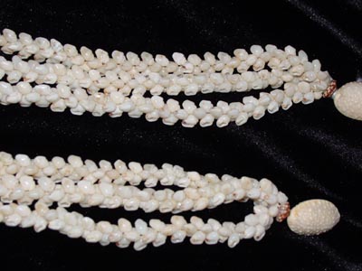
There are three different shells primarily used to make Ni‘ihau shell lei: kahelelani, momi and laiki. The color of the shells range from bright pink to pale yellow, and can have various types of markings on them.

Fabricating shell lei was not limited to Ni‘ihau, but it was there that this Hawaiian art flourished, most likely due to the abundance of shells available on the island’s beaches and the scarcity of flowers because of the arid climate.

In 1887, Queen Kapi‘olani had a formal portrait taken in New York on her way to attend Queen Victoria’s Jubilee. In the portrait, she wore a multi-strand lei of ivory-colored Ni‘ihau shells which complemented her formal Victorian dress.

Queen Emma, who showed more appreciation of Hawaiian crafts than any other of the Hawaiian royalty, also wore Ni‘ihau shell lei for formal portraits as well as when she was presented to Her Britannic Majesty.

It should be noted that during this time the shell lei was adapted to Victorian jewelry styles which included adding a clasp, thus elevating the traditional lei to the status of a piece of fine jewelry which was worn with the most elegant Western dress.

It is also interesting to note that later, particularly during the early- and mid-1900s, shell lei were more commonly reserved for occasions when Hawaiian attire was worn.

© 2023 Ho‘okuleana LLC

Filed Under: Economy, General, Ali'i / Chiefs / Governance, Hawaiian Traditions Tagged With: Hawaii, Niihau, Lei, Niihau Lei Pupu, Kahelelani, Momi, Laiki, Shell

  • 1
  • 2
  • 3
  • Next Page »

Images of Old Hawaiʻi

People, places, and events in Hawaiʻi’s past come alive through text and media in “Images of Old Hawaiʻi.” These posts are informal historic summaries presented for personal, non-commercial, and educational purposes.

Info@Hookuleana.com

Connect with Us

  • Email
  • Facebook
  • LinkedIn
  • Twitter
  • YouTube

Recent Posts

  • ʻŌpūkahaʻia Leaves Hawaiʻi
  • Moku
  • About 250 Years Ago … Story of the American Soldier
  • German Town
  • Nā Wai ʻEhā
  • Kāʻanapali Historical Trail & History and Legends Tour
  • Kakaʻako

Categories

  • General
  • Ali'i / Chiefs / Governance
  • Buildings
  • Missionaries / Churches / Religious Buildings
  • Hawaiian Traditions
  • Military
  • Place Names
  • Prominent People
  • Schools
  • Sailing, Shipping & Shipwrecks
  • Economy
  • Voyage of the Thaddeus
  • Mayflower Summaries
  • American Revolution

Tags

Albatross Al Capone Ane Keohokalole Archibald Campbell Bernice Pauahi Bishop Charles Reed Bishop Downtown Honolulu Eruption Founder's Day George Patton Great Wall of Kuakini Green Sea Turtle Hawaii Hawaii Island Hermes Hilo Holoikauaua Honolulu Isaac Davis James Robinson Kamae Kamaeokalani Kameeiamoku Kamehameha Schools Lalani Village Lava Flow Lelia Byrd Liberty Ship Liliuokalani Mao Math Mauna Loa Midway Monk Seal Northwestern Hawaiian Islands Oahu Papahanaumokuakea Marine National Monument Pearl Pualani Mossman Quartette Thomas Jaggar Volcano Waikiki Wake Wisdom

Hoʻokuleana LLC

Hoʻokuleana LLC is a Planning and Consulting firm assisting property owners with Land Use Planning efforts, including Environmental Review, Entitlement Process, Permitting, Community Outreach, etc. We are uniquely positioned to assist you in a variety of needs.

Info@Hookuleana.com

Copyright © 2012-2024 Peter T Young, Hoʻokuleana LLC

Loading Comments...