Images of Old Hawaiʻi

  • Home
  • About
  • Categories
    • Ali’i / Chiefs / Governance
    • American Protestant Mission
    • Buildings
    • Collections
    • Economy
    • Missionaries / Churches / Religious Buildings
    • General
    • Hawaiian Traditions
    • Other Summaries
    • Mayflower Summaries
    • Mayflower Full Summaries
    • Military
    • Place Names
    • Prominent People
    • Schools
    • Sailing, Shipping & Shipwrecks
    • Voyage of the Thaddeus
  • Collections
  • Contact
  • Follow

October 2, 2024 by Peter T Young 1 Comment

Fort Weaver

ʻEwa was comprised of twelve ahupuaʻa. Some stories, when first recorded in the 19th- Century, refer to ʻEwa as the first area populated on Oʻahu by the immigrant Polynesians. Puʻuloa or Ke Awa Lau O Puʻuloa (the many harbored-sea of Puʻuloa) is situated here.

The first known foreigner to enter the area, Captain George Vancouver, started to explore the area, but stopped when he realized that the entrance was not deep enough for large ships to pass through.

“If the water upon the bar should be deepened, which I doubt not can be effected, it would afford the best and most capacious harbor in the Pacific.” (Commodore Charles Wilkes, 1840)

Puʻuloa and Ke Awa Lau O Puʻuloa are just a couple of its traditional names. It was also known as Awawalei (“garland (lei) of harbors,”) Awalau (“leaf-shaped lagoon”) and Huhui na ʻōpua i Awalau (The clouds met at Awalau.) Today, we generally call this place Pearl Harbor.

In 1872, Major General John M Schofield, Commander of the Army Division of the Pacific, came to Hawaiʻi on a mission to evaluate the defense possibilities of various Hawaiian ports.

Recognizing the potential importance of Puʻuloa (Pearl Harbor) that could be inexpensively and effectively defended, he recommended that it be developed as a military base.

As a means of solidifying a site in the central Pacific, the US negotiated an amendment to the Treaty of Reciprocity with King Kalākaua in 1887, adding a clause granting to US vessels the exclusive privilege of entering Pearl Harbor. The US then began building a coaling and repair station there.

As part of the defense of Pearl Harbor and nearby Honolulu, the US Army constructed forts and artillery batteries at the mouth of Pearl Harbor and along the southern shores of Oʻahu, beginning in the early twentieth century.

These fortifications were constructed for defense purposes and had the capability to fire ordnance (projectiles ranging in size from small arms up to 16-in) beyond the shores of Oʻahu in the event of enemy attack.

The batteries were dispersed for concealment and spaced to insure that enemy fire striking one would not thereby endanger a neighbor. They were open to the rear, to facilitate ammunition service at a rapid rate.

The Army acquired land along the ʻEwa shoreline in about 1905 to support the coastal defense. The Navy took control of the property in August 1916.

It became known as Puʻuloa Military Reservation of Oʻahu. The Navy developed this area into a small‐arms range, and by 1927, the Puʻuloa Naval Reservation became known as the Navy Rifle Range.

Until 1922, the coastal defense portion of the place was also known as Iroquois Point Military Reservation. The name “Iroquois Point” was derived from the name “USS Iroquois;” it is believed that the ship was anchored nearby while serving in the Marine Hospital Service. Her name was later changed to Ionie.

In 1922, the coastal defense facility was named Fort Weaver; named after Erasmus Morgan Weaver, Jr, a US Army Major General who served as the first chief of the Militia Bureau and the Chief of the Army’s US Army Coast Artillery Corps.

Fort Weaver consisted of Battery Williston (1924 – 1948,) Battery Weaver (1934 – 1944,) four Panama mounts and Anti Motor Torpedo Boat Battery #1 (1943 – 1945.)

Construction on Battery Williston began in October 1921 and was transferred for service on September 19, 1924. This was a two gun 16” all round fire battery emplaced in the open on circular concrete pads. These guns were mounted on long range carriages that elevated to 35 degrees for maximum range.

After activation, Battery Williston was serviced by troops who arrived by boat from nearby Fort Kamehameha (across the entrance channel into Pearl Harbor.) Later a small facility was built on site to accommodate the soldiers, there.

In 1934, Battery 155 – Fort Weaver was positioned in front of Battery Williston. This battery consisted of four 155-mm guns on mobile carriages placed on fixed concrete Panama mounts.

Located more towards ʻEwa Beach was Naval Antiaircraft Shore Battery No. 3 (1942 – 1944,) with four 5-inch naval guns, adjacent to the Navy’s Fleet Machine Gun Training School.

The fire power of coast defense remained the heavy gun, the 1919-model sixteen-inch rifle – a 79-foot, 187-ton weapon that could fire a 2,340-pound projectile over 28-miles with overwhelming accuracy.

The guns were protected only by camouflage netting and paint (they were not protected with concrete encasements, like many of the other Forts and Batteries on O‘ahu.)

Numerous training activities at the forts and artillery batteries conducted up until about 1948 involved firing into waters of the south shore in the vicinity of Pearl Harbor.

Since the guns’ barrels only had a useful life of about 120-rounds, the Army adopted a plan to store spare barrels at the various batteries.

In 1949, Fort Weaver was transferred to the Navy (as the Puʻuloa Naval Reservation) and, since the 1950s, has been used for military housing. The site of the Fort and Batteries is between the present-day USMC Pu‘uloa Rifle Range and the Pearl Harbor entrance channel.

© 2024 Hoʻokuleana LLC

Fort_Weaver-(LOC)
Fort_Weaver-(LOC)
Erasmus_Morgan_Weaver,_Jr.
16-in_gun_BatteryWilliston_FortWeaver_1940
16-in_gun_FortKam_or_FortWeaver_1940
Puuloa-Targets-MCBH
Puuloa-Targets-MCBH
Puuloa-Tents-MCBH
Puuloa-Tents-MCBH
Fire_Control_Tower-Battery_Williston-built-1924-Below_Beach_Defense_Pillbox-(DefenseOfPearlHarborAndOahu)-1934
Fort_Pickens_Battery_Cooper_Panama Mount- representative of Fort Weaver
Fort_Weaver-GoogleEarth
Battery_155_-_Fort_Weaver_Plan
Fort_Weaver_1934_Plan

Filed Under: Military, Place Names Tagged With: Hawaii, Ewa, Puuloa, Ke Awa Lau O Puuloa, Fort Weaver

October 8, 2023 by Peter T Young Leave a Comment

ʻEwa

Today, you don’t necessarily use the words ʻEwa and Kalo in the same sentence – we tend to think of the ʻEwa district as dry and hot, not as a wetland taro production region.  Some early written descriptions of the place also note the dry ʻEwa Plains.

In 1793, Captain George Vancouver described this area as desolate and barren:  “From the commencement of the high land to the westward of Opooroah (Puʻuloa – Pearl Harbor) was … one barren rocky waste, nearly destitute of verdure, cultivation or inhabitants, with little variation all to the west point of the island. …”

In 1839, Missionary EO Hall described the area between Pearl Harbor and Kalaeloa as follows: “Passing all the villages (after leaving the Pearl River) at one or two of which we stopped, we crossed the barren desolate plain”.  (Robicheaux)

However, not only was ʻEwa productive, its taro was memorable.

Ua ʻai i ke kāī-koi o ‘Ewa.
He has eaten the kāī-koi taro of ‘Ewa.

Kāī is O‘ahu‘s best eating taro; one who has eaten it will always like it. Said of a youth or maiden of ‘Ewa, who, like the Kāī taro, is not easily forgotten.  (ʻŌlelo Noʻeau, 2770, Pukui)

The island of Oʻahu is divided into 6 moku (districts), consisting of: ‘Ewa, Kona, Koʻolauloa, Koʻolaupoko, Waialua and Waiʻanae. These moku were further divided into 86 ahupua‘a (land divisions within a moku.)

‘Ewa was divided into 12-ahupua‘a, consisting of (from east to west): Hālawa, ‘Aiea, Kalauao, Waimalu, Waiau, Waimano, Mānana, Waiʻawa, Waipi‘o, Waikele, Hōʻaeʻae and Honouliuli.

‘Ewa was at one time the political center for O‘ahu chiefs. This was probably due to its abundant resources that supported the households of the chiefs, particularly the many fishponds around the lochs of Puʻuloa (“long hill,) better known today as Pearl Harbor. (Cultural Surveys)  ʻEwa was the second most productive taro cultivation area on Oʻahu (just behind Waikīkī.)  (Laimana)

The salient feature of ‘Ewa, and perhaps its most notable difference, is its spacious coastal plain, surrounding the deep bays (“lochs”) of Pearl Harbor, which are actually the drowned seaward valleys of ‘Ewa’s main streams, Waikele and Waipi‘o…The lowlands, bisected by ample streams, were ideal terrain for the cultivation of irrigated taro.  (Handy, Cultural Surveys)

‘Ewa was known for a special and tasty variety of kalo (taro) called kāī which was native to the district. There were four documented varieties; the kāī ʻulaʻula (red kāī), kāī koi (kāī that pierces), kāī kea or kāī keʻokeʻo (white kāī), and kāī uliuli (dark kāī.)  (Handy)

Handy says about ‘Ewa: “The lowlands, bisected by ample streams, were ideal terrain for the cultivation of irrigated taro. The hinterland consisted of deep valleys running far back into the Koʻolau range.”

“Between the valleys were ridges, with steep sides, but a very gradual increase of altitude. The lower parts of the valley sides were excellent for the culture of yams and bananas. Farther inland grew the ‘awa for which the area was famous.”

“The length or depth of the valleys and the gradual slope of the ridges made the inhabited lowlands much more distant from the wao, or upland jungle, than was the case on the windward coast. Yet the wao here was more extensive, giving greater opportunity to forage for wild foods in famine time. (Handy)

Earlier this century, a few fishermen and some of their families built shanties by the shore where they lived, fished and traded their catch for taro at ‘Ewa. Their drinking water was taken from nearby ponds, and it was so brackish that other people could not stand to drink it.  (Maly)

An 1899 newspaper account says of the kāī koi, “That is the taro that visitors gnaw on and find it so good that they want to live until they die in ‘Ewa. The poi of kai koi is so delicious”. (Ka Loea Kalai ʻĀina 1899, Cultural Surveys) So famous was the kāī variety that ‘Ewa was sometimes affectionately called Kāī o ‘Ewa.

“I think it (wetlands) went all the way behind the Barbers Point beach area. … We’d go swim in the ponds back there, it was pretty deep, about two feet, and the birds were all around. … It seems like when there were storms out on the ocean, we’d see them come into the shore, but they’re not around anymore.”

“The wet land would get bigger when there was a lot of rain, and we had so much fun in there, but now the water has nearly all dried up. They even used to grow wet-land taro in the field behind the elementary school area when I was young. (Arline Wainaha Pu‘ulei Brede-Eaton, Maly Interview)

 ”… Bountiful taro fields covered the plain and countless coconut palms, with several huts in their shade beautified the country side. … The taro fields, the banana plantations, the plantations of sugar cane are immeasurable.” (A Botanist’s Visit to Oahu in 1831, Journal of Dr FJF Meyen, Maly)

“This district, unlike others of the island, is watered by copious and excellent springs that gush out at the foot of the mountains. From these run streams sufficient for working sugar-mills. In consequence of this supply, the district never suffers from drought, and the taro-patches are well supplied with water by the same means.”  (Commander Charles Wilkes, 1840-1841, Maly)

“Rev. Artemas Bishop, in the summer of 1836, removed with his wife and two children from Kailua, Hawaii, to Ewa, Oahu.  … Throughout the district of Ewa the common people were generally well fed. Owing to the decay of population, great breadths of taro marsh had fallen into disuse, and there was a surplus of soil and water for raising food.”  (SE Bishop, The Friend, May 1901)

As in other areas, kalo loʻi converted to rice patties.  “These days at ‘Ewa, the planting of rice is spreading among the Chinese and the Hawaiians, from Hālawa to Honouliuli and beyond. There will come a day when the mother food, taro, shall not be seen on the land.”  (Ka Lahui Hawaii, May 3, 1877, Maly)

Of course, in our discussion of the ʻEwa Moku, we need to remember that it ran from Hālawa to Honouliuli and circled Pearl Harbor.  Much of the watered wetland taro was produced off of streams from the Koʻolau; however, there is considerable mention of the wetland taro of Honouliuli (what we generally refer to today as ʻEwa.)

© 2023 Hoʻokuleana LLC

Filed Under: Economy, Place Names Tagged With: Waikele, Aiea, Ewa, Puuloa, Kalauao, Hoaeae, Hawaii, Waimano, Oahu, Waiau, Honouliuli, Manana, Pearl Harbor, Waimalu, Halawa, Waiawa, Waipio

July 14, 2023 by Peter T Young 2 Comments

Ke Awa Lau O Puʻuloa

During ancient times, various land divisions were used to divide and identify areas of control. Islands were divided into moku; moku were divided into ahupuaʻa. A common feature in each ahupuaʻa was water, typically in the form of a stream or spring.

The Island of O’ahu had six Moku: Kona, Koʻolaupoko, Koʻolauloa, Waialua, Waiʻanae and ʻEwa.

‘Ewa was divided into 12-ahupua‘a, consisting of (from east to west): Hālawa, ‘Aiea, Kalauao, Waimalu, Waiau, Waimano, Mānana, Waiʻawa, Waipi‘o, Waikele, Hōʻaeʻae and Honouliuli.

Some stories, when first recorded in the 19th- Century, refer to ʻEwa as the first area populated on Oʻahu by the immigrant Polynesians. ‘Ewa was at one time the political center for O‘ahu chiefs.

This was probably due to its abundant resources that supported the households of the chiefs, particularly the many fishponds around the lochs of Puʻuloa (“long hill,) better known today as Pearl Harbor. (Cultural Surveys)

Each had fisheries in the harbor, floodplains with irrigated kalo and fishponds, and interior (lower kula valley streams/gulches) and mountain forests. (Kirch)

Puʻuloa or Ke Awa Lau O Puʻuloa (the many harbored-sea of Puʻuloa) is situated here.

All water sources in each of the twelve ahupuaʻa of ʻEwa met in Puʻuloa. This was the only moku in all the islands where all waters from its ahupuaʻa did this.

Puʻuloa and Ke Awa Lau O Puʻuloa are just a couple of its traditional names. It was also known as Awawalei (“garland (lei) of harbors,”) Awalau (“harbor with many inlets”) and Huhui na ʻōpua i Awalau (The clouds met at Awalau.)

Today, we generally call this place Pearl Harbor. The name Pearl Harbor is one of the few English place names in Hawaiʻi that is a close translation of another of its traditional Hawaiian names, Wai Momi (“Pearl Water.”)

Some of the traditional themes associated with this area include connections with Kahiki (Tahiti,) the traditional homeland of Hawaiians.

Legend tells that Kanekuaʻana (a moʻo, or water lizard) came from Kahiki and brought with her the pipi, or pearl oyster. The harbor was teeming with pearl-producing oysters until the late-1800s. (The general belief is that runoff sedimentation eventually smothered the oyster habitat.)

The pipi was called the “iʻa hamau leo” or “fish with a silenced voice.” It was not the pipi that was silent but the people who gathered them (if they spoke, wind would ripple the water and the oysters would vanish.)

There are several versions of the chief Kahaʻi leaving from Kalaeloa (Barber’s Point) for a trip to Kahiki; on his return to the Hawaiian Islands, he brought back the first breadfruit and planted it at Puʻuloa.

Traditional accounts indicate several of the fishponds in the Puʻuloa area were believed to have been constructed by Kāne and Kanaloa. Directing the menehune, they made the pond Kapākule (aka Pākule,) which they stocked with all manner of fish. (Kumupono, Hoakalei)

“On the left side of [Kapākule] pond stood the stone called Hina, which represented a goddess of the sea by that name. Each time the sea ebbed, the rock became gradually visible, vanishing again under water at high tide. Ku, another stone on the right, was never seen above sea level. This stone represented Ku’ula, Red Ku, a god of fish and fishermen. (Pukui)

“[T]he harbor of Ewa, or Pearl River, [is] situated on the Island of Oahu, about 7 miles west of Honolulu. Pearl River is a fine sheet of deep water extending inland about 6 miles from its month …”

“Pearl River is not a true river; it partakes more of the character of an estuary. It is divided into three portions called ‘locks’ – the east lock, the middle lock, and the west lock, the three together affording some 30 miles of water front, with deep water in the channels.” (General JM Schofield and General BS Alexander, 1872)

Puʻuloa Salt Works (property of JI Dowsett) “are at the west side of the entrance to Pearl River, and the windmill is a prominent object in the landscape as we enter. It is also one of the guides in steeling vessels inward. On the eastern side and opposite to the Puʻuloa buildings, is the fishery, where are a number of buildings inhabited by Chinamen.” (Daily Bulletin, January 6, 1889)

Puʻuloa was originally an extensive, shallow embayment. Keaunui, the head of the powerful and celebrated ʻEwa chiefs, is attributed for having cut a navigable channel near the Puʻuloa saltworks, by which the great estuary, known as “Pearl River,” was for the first time rendered accessible to navigation.

Puʻuloa was regarded as the home of the shark goddess Kaʻahupahau and her brother Kahiʻuka in Hawaiian legends. They were said to live in a cave at the entrance to Puʻuloa and guarded the waters against man-eating sharks.

“There is ample evidence that the lonely scenes, upon which we now gaze with wondering curiosity, were once thickly peopled; and at that period the gospel had not reached Pearl River. Among the objects of their heathen worship was the shark, whoso numbers at Pearl River in those days were very abundant.” (Daily Bulletin, January 6, 1889)

Moku‘ume‘ume (meaning “island of strife”) is a small island located in Pearl Harbor on the Island of Oʻahu. It is entirely surrounded by water deep enough to accommodate deep draft ocean-going vessels. We now call it Ford Island.

The first known foreigner to enter the channel of the Pearl Harbor area, Captain George Vancouver, started to explore the area, but stopped when he realized that the entrance was not deep enough for large ships to pass through.

“If the water upon the bar should be deepened, which I doubt not can be effected, it would afford the best and most capacious harbor in the Pacific.” (Commodore Charles Wilkes, 1840)

In the nineteenth century, the peninsula between Middle Loch and East Loch (part of the Mānana ahupuaʻa) had numerous fishponds, some rice fields, pasture land at the tip, and oyster beds offshore.

As a means of solidifying a site in the central Pacific, the US negotiated an amendment to the Treaty of Reciprocity in 1887. King Kalākaua in his speech before the opening session of the 1887 Hawaiian Legislature stated (November 3, 1887:)

“I take great pleasure in informing you that the Treaty of Reciprocity with the United States of America has been definitely extended for seven years upon the same terms as those in the original treaty …”

“… with the addition of a clause granting to national vessels of the United States the exclusive privilege of entering Pearl River Harbor and establishing there a coaling and repair station.”

“This has been done after mature deliberation and the interchange between my Government and that of the United States of an interpretation of the said clause …”

“… whereby it is agreed and understood that it does not cede any territory or part with or impair any right of sovereignty or jurisdiction on the part of the Hawaiian Kingdom and that such privilege is coterminous with the treaty.”

“I regard this as one of the most important events of my reign, and I sincerely believe that it will re-establish the commercial progress and prosperity which began with the Reciprocity Treaty.” (Kalākaua)

In 1890 some of the Mānana lands became the first planned subdivision outside of urban Honolulu (Pearl City, named in a contest and developed by Benjamin F Dillingham as a way to increase passenger traffic on his Oahu Railway and Land Company (OR&L) trains.)

© 2023 Hoʻokuleana LLC

Filed Under: Place Names Tagged With: Ke Awa Lau O Puuloa, Hawaii, Oahu, Kalakaua, Pearl Harbor, Treaty of Reciprocity, Oahu Railway and Land Company, Dillingham, Ewa

December 12, 2022 by Peter T Young Leave a Comment

Kalauao

At the time of Cook’s arrival (1778,) the Hawaiian Islands were divided into four kingdoms: (1) the island of Hawaiʻi under the rule of Kalaniʻōpuʻu, who also had possession of the Hāna district of east Maui; (2) Maui (except the Hāna district,) Molokaʻi, Lānaʻi and Kahoʻolawe, ruled by Kahekili; (3) Oʻahu, under the rule of Kahahana; and at (4) Kauaʻi and Niʻihau, Kamakahelei was ruler.

“At that time Kahekili was plotting for the downfall of Kahahana and the seizure of Oahu and Molokai, and the queen of Kauai was disposed to assist him in these enterprises.”  (Kalākaua)  Kamakahelei was married to Kāʻeokūlani (Kāʻeo – younger brother of Kahekili.)  Kamakahelei and Kāʻeo had a son Kaumualiʻi (born in 1778 at Holoholokū.)

Kahekili and his eldest son and heir-apparent, Kalanikūpule, conquered Kahahana, adding Oʻahu under his control.  And, in the late-1780s into 1790, Kamehameha conquered the Island of Hawai‘i and was pursuing conquest of Maui and eventually sought to conquer the rest of the archipelago.

The rich resources of the region, the shoreline fishponds, the numerous springs, and the fertile lands along the streams made ‘Ewa a prize for competing chiefs. Battles were fought for and on ‘Ewa lands, sometimes from competing O‘ahu chiefs, and sometimes by invading chiefs from other islands.  (Cultural Surveys)

At the death of Kahekili in 1793, Kāʻeo became ruling chief of Maui, Molokaʻi and Lānaʻi.  Kalanikūpule was ruler of Oʻahu.  Homesick for his friends, Kāʻeo set out to return to Kauaʻi by way of Waialua and then to Waimea.  He learned of a conspiracy to kill him and by November, 1794, Kāʻeo and Kalanikūpule were ready to fight.  (Kamakau)

Kāʻeo was successful after some initial skirmishes.  On December 12, 1794, a great battle was fought in the area between Kalauao and ‘Aiea in ‘Ewa.  Kalanikūpule’s forces surrounded Kāʻeo.  (Cultural Surveys)

Kāʻeo with six of his men escaped into a ravine below ‘Aiea and might have disappeared there had not the red of his feather cloak been seen from the boats at sea and there shots drawn the attention of those on land. Hemmed in from above, he was killed fighting bravely.  (Kamakau)

This war, called Kukiʻiahu, was fought from November 16 to December 12, 1794 at Kalauao in ‘Ewa.  (Kamakau)  (It wasn’t long after that Kalanikūpule battled Kamehameha, again; and lost to Kamehameha at the Battle of Nuʻuanu.)

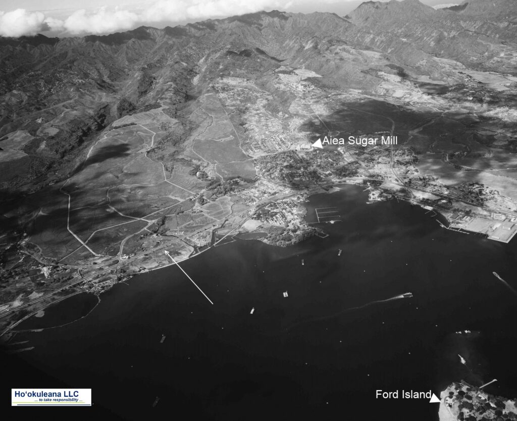
Kalauao Ahupua‘a (the multitude of clouds) extends from the East Loch of Pearl Harbor to the crest of the Koʻolau Range, generally following Kalauao Stream. Kalauao Spring is located near the Pearl Harbor coast.

The Kalauao Spring included two natural springs of percolating water.  In ancient times, the springs irrigated taro loʻi.  Later, the ancient taro lo‘i and ʻauwai (irrigation ditches) were modified and expanded to support rice cultivation.

In 1904, the area was described as, “On the morning of June 2nd, for instance, our destination was Aiea. At ten minutes past seven we boarded the first passenger train going towards Honolulu.”

“For a distance of eight miles the road skirts the shore and then turns landwards or mauka through rice and sugar plantations, Ewa Mill, Waipahu, Pearl City. …”

“Like all rice fields in Hawaii, this one is worked entirely by Chinamen, they alone being able to endure the conditions of location and climate necessary for the cultivation of this cereal.”

“On one side of the railroad track was the broad, muddy inland lake or bay of salt water, Pearl Harbor; on the other side were the terraced plots or fields, flooded to a depth of several inches with water and separated by narrow raised earthen ridges on which the careful Chinaman doubtless succeeded in walking, but which many times proved treacherous to our unsteady feet.”

“A rice plantation, laid out as it generally is on the low flats at the foot of a valley, where mountain streams empty into the sea, is an ideal collecting ground for certain kinds of algae.”  (Thrum 1904)

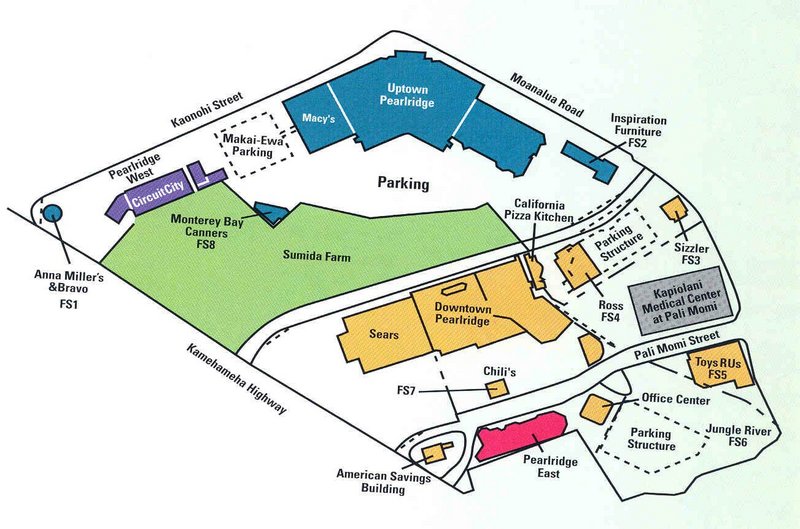
In 1928, Moriichi and Makiyo Sumida began farming assorted wetland produce on a two-acre plot of land at the springs.  Back then, the area of the springs contained many small farms growing similar produce — bananas, taro, rice, and watercress. Through the ensuing years, the Sumida property grew as they acquired neighboring leases and, by 1950, watercress became the sole crop.  (NPS)

A small waterfall along Kalauao Stream, named Kahuawai (or Kahuewai), was located along the coastal trail connecting Honolulu to Waiʻanae.  Kahuawai (water gourd container) was indicated to have been “a favorite resting place exclusively for chiefs”.  (Cultural Surveys)

Kahuawai was a noted bathing place since ancient times and was guarded so that any one did not bathe in it except the chiefs. Later it was used by all. Kākuhihewa’s daughters and the hero Kalelealuaka (their husband) bathed in this pool. Kāʻeokūlani, the chief of Kauaʻi also bathed here when he came to war here on Oʻahu.  (Cultural Surveys)

Loko Opu, a large fishpond (approximately 10.5-acres in size) located in Kalauao along the Pearl Harbor coast, is said to have been built by the chiefess Kalamanuʻia.  (Cultural Surveys)

During the Māhele, much of the lands in the ahupua‘a of ‘Ewa, as in other districts, were awarded to Ali‘i Nui (high chiefs), who were either the grandchildren or great-grandchildren of Kamehameha I.

Half of the ahupua‘a of Kalauao was awarded to Laura Konia (either granddaughter or grandniece of Kamehameha I;) the other half of Kalauao Ahupua‘a was awarded to John Meek, an important merchant in the sandalwood trade.

Today, the Pearl Country Club covers much of the lower section of Kalauao.   Pearlridge Shopping Center is on the lowest side of Kalauao (Pearlridge Uptown was opened in 1972, with an expansion in 1976 to include Pearlridge Downtown.)  Pearlridge surrounds the evidence of the water resources of old, Kalauao Spring that benefits the Sumida watercress farm.

© 2022 Hoʻokuleana LLC

Filed Under: Place Names Tagged With: Ewa, Sumida Watercress, Kalauao, Pearlridge, Hawaii, Oahu, Kalanikupule, Ahupuaa, Kaeo

October 9, 2022 by Peter T Young Leave a Comment

Kalaeloa

Kalaeloa is literally translated as, “the distant point or the long cape.”  It is situated on the ʻEwa Plain in the ahupuaʻa of Honouliuli.

Kalaeloa region was a very good place for fishing and shoreline collecting; the koʻa (fishing ground) outside of Kalaeloa is called Hani-o. (Beckwith)

A nearby heiau on Puʻu o Kapolei (hill of beloved Kapo (sister of Pele)) marked the movements of the sun and served as an astronomical marker to designate the seasons.

“(T)he people of Oʻahu reckoned from the setting of the sun at Puu-o-Kapolei, until it set in the hollow of Mahinaona, it was called Kau. And from Puu-o-Kapolei, the sun moved south (noting winter).”  (Polynesian Voyaging Society)

The area between Puʻu o Kapolei and Kalaeloa is known as Kaupeʻa (what we generally refer to as the ʻEwa Plain.)  Kaupeʻa is said to be the realm of the ao kuewa or ao ‘auwana (the homeless or wandering souls). Kaupeʻa was the wandering place of those who died having no rightful place to go.  (Maly)

In 1793, Captain George Vancouver described this area as desolate and barren:  “From the commencement of the high land to the westward of Opooroah (Puʻuloa – Pearl Harbor) was … one barren rocky waste, nearly destitute of verdure, cultivation or inhabitants, with little variation all to the west point of the island. …”

In 1839, Missionary EO Hall described the area between Pearl Harbor and Kalaeloa as follows: “Passing all the villages (after leaving the Pearl River) at one or two of which we stopped, we crossed the barren desolate plain”.  (Robicheaux)  In the 1880s, these lands were being turned over to cattle grazing and continued through the early-1900s.

Kalaeloa was first renamed on June 5, 1786 by British Captain Nathanial Portlock – he named the cape Point Banks, honoring his patron Sir Joseph Banks.  (Banks was  the naturalist on Captain Cook’s first voyage into the Pacific.)

However, the cape was shortly thereafter given a new name, as a result of an unfortunate grounding of the ‘Arthur’ at that point on October 31, 1796; the ship was captained by Henry Barber.

“Unscrupulous, tyrannical, opportunistic, over-reaching and a trifle-fond of the bottle” is a brief description by one of Captain Barber.  (Scott)

On a voyage to China, Barber called at Honolulu for supplies. He left Honolulu, heading for Kauaʻi to get a supply of yams, at about 6 pm, October 31. At 8:10 pm Barber’s ship struck a coral shoal.

After scraping bottom, Barber and his crew of twenty-two, manned the life-boats and reached shore through the pounding surf (six drowned in the process.)  The Arthur was driven on the reef and broke up.

The next morning when Barber returned to the wrecked Arthur he found there John Young, who happened to be on Oʻahu at the time and, learning of the disaster, hurried to the scene to take charge of the efforts to salvage the cargo.  (Howay)

Barber was a successful and influential trader across the Pacific.  “If America was the main supplier of the Australian market in the years immediately succeeding the settlement of Port Jackson (Sydney), India was a close contender. Captain Henry Barber, Master of the 85-ton snow Arthur, operated from both centres …” (Journal of the Polynesian Society) He included China in his trade loop.

“(T)here were but 500 otter skins on board when she was cast away, which he carried with him to Canton, 500 otter skins in those days were worth some $20 to $40,000”  (Polynesian, February 8, 1851) The greater part of the skins and ships stores were saved.

Several years later, on his way to China, Barber passed through Hawaiʻi again (December 17, 1802.)  He learned that King Kamehameha had retrieved ten guns off the wreck of the Arthur and installed them for the defense of a newly built fort in Lāhainā, Maui.

Barber claimed the guns were his, but Kamehameha refused, claiming possession was nine-tenths of the law.  To top it off, since Barber was in Hawaiʻi to reprovision, Kamehameha made Barber pay for his supplies with gunpowder.

Since the grounding of the Arthur, the point has been associated with the captain of the ill-fated ship. In 1968, the US Board of Geographic Names dropped the apostrophe, changing the name from Barber’s Point to Barbers Point.

This wasn’t the only wreck, here.  In looking for a lighthouse here in 1880, Hawaiian government surveyor William Alexander noted, “I examined the coast for some miles in the neighborhood of Barber’s Point, selected a site for a light house and marked the spot by a pile of stones and a staff with a red and white flag. I also fixed the position … where there are several pieces of … the French whaleship Marquis de Turenne, which was wrecked about a mile off the point in 1855.”  (Lighthouse Friends)

“A shoal with only 6 to 10 feet of water on it is said to extend 2 to 3 miles south by west from the point, and it should be sounded. In fact it is a question whether the light house might not be placed on a shallow spot or “okohola” whale’s back, as the natives call it, a mile or more offshore.”  (Alexander, Lighthouse Friends)

The first Barbers Point lighthouse tower was “constructed of coral (another source noted lava) in the days of King Kalākaua in 1888”. It stood 42 feet.

The current 72-foot tower was built in 1933.  The older tower was intentionally toppled on 29 December 1933, the same day the new tower was lit.   The light was automated in 1964.

Aviation facilities were also constructed nearby.  Starting in 1925, a mooring mast for lighter-than-air dirigibles was erected.  The original field was called Navy Mooring Mast Field because the Navy had originally planned to have the ‘Akron’ based there when in Hawaiʻi. But the ‘Akron’ crashed, ending the project.  The mooring mast was taken down in 1932 and planning moved forward for other aviation facilities.

Around 1940, two air stations were built at Kaupeʻa (the ʻEwa Plain the Naval Air Station Barber’s Point, the larger and the Marine Corps Air Station, ʻEwa, the smaller.)  Following the outbreak of World War II, facilities were expanded to sustain four carrier groups.

Ewa was officially closed on June 18, 1952 and its property assumed by Naval Air Station Barbers Point.  (The thirty-two revetments on the property, originally designed to shield aircraft from bomb blasts, have served as stables since the 1950s and provide a home for approximately 50 horses.)

Barbers Point was decommissioned by the Navy in 1998 and turned over to the State of Hawaiʻi for use as Kalaeloa Airport and is used by the US Coast Guard, Hawaii Community College Flight Program, Hawaiʻi National Guard and general aviation, as well as an alternate landing site for Honolulu International Airport.

© 2022 Hoʻokuleana LLC

Filed Under: Place Names Tagged With: Hawaii, Oahu, Kalaeloa, Ewa, Barbers Point

  • 1
  • 2
  • 3
  • Next Page »

Images of Old Hawaiʻi

People, places, and events in Hawaiʻi’s past come alive through text and media in “Images of Old Hawaiʻi.” These posts are informal historic summaries presented for personal, non-commercial, and educational purposes.

Info@Hookuleana.com

Connect with Us

  • Email
  • Facebook
  • LinkedIn
  • Twitter
  • YouTube

Recent Posts

  • Happy Mother’s Day!
  • 250 Years Ago … Green Mountain Boys
  • Rock Silo to Bell Tower
  • Mourning Kamehameha’s Death
  • Kawaihae Harbor
  • Education in Hawaiʻi
  • Cinco de Mayo

Categories

  • General
  • Ali'i / Chiefs / Governance
  • Buildings
  • Missionaries / Churches / Religious Buildings
  • Hawaiian Traditions
  • Military
  • Place Names
  • Prominent People
  • Schools
  • Sailing, Shipping & Shipwrecks
  • Economy
  • Voyage of the Thaddeus
  • Mayflower Summaries
  • American Revolution

Tags

Albatross Al Capone Ane Keohokalole Archibald Campbell Bernice Pauahi Bishop Charles Reed Bishop Downtown Honolulu Eruption Founder's Day George Patton Great Wall of Kuakini Green Sea Turtle Hawaii Hawaii Island Hermes Hilo Holoikauaua Honolulu Isaac Davis James Robinson Kamae Kamaeokalani Kamanawa Kameeiamoku Kamehameha Schools Lalani Village Lava Flow Lelia Byrd Liliuokalani Mao Math Mauna Loa Midway Monk Seal Northwestern Hawaiian Islands Oahu Papahanaumokuakea Marine National Monument Pearl Pualani Mossman Queen Liliuokalani Thomas Jaggar Volcano Waikiki Wake Wisdom

Hoʻokuleana LLC

Hoʻokuleana LLC is a Planning and Consulting firm assisting property owners with Land Use Planning efforts, including Environmental Review, Entitlement Process, Permitting, Community Outreach, etc. We are uniquely positioned to assist you in a variety of needs.

Info@Hookuleana.com

Copyright © 2012-2024 Peter T Young, Hoʻokuleana LLC


Loading Comments...