During ancient times, various land divisions were used to divide and identify areas of control. Islands were divided into moku (districts;) moku were divided into ahupuaʻa. A common feature in each ahupuaʻa was water, typically in the form of a stream or spring.
The Island of Oʻahu has six Moku (districts:) Kona, Koʻolaupoko, Koʻolauloa, Waialua, Waiʻanae and ʻEwa. The Moku of Koʻolauloa extends from Kalaeokaʻoiʻo (ʻOiʻo Point) in Kualoa to Waimea Bay.
Situated on the koʻolau (windward) side of the island, much of Koʻolauloa had ample rainfall, rich forests, streams, sheltered valleys, broad flat lands, reef protected shores, and rich estuarine environments to support nearshore fisheries.
The area that we refer to today as Lāʻie in Koʻolauloa (short for “lau ʻie; ʻie vine leaf; Pukui – referring to the red-spiked climbing pandanus tree) is made up of two ahupuaʻa, Lāʻiewai (wet Lāʻie) and Lāʻiemaloʻo (dry Lāʻie.)
Hawaiian mythology notes the ʻie vine is sacred to the god Kāne, the procreator, and the goddess of hula, Laka. The area of Lāʻie, prior to Western contact, provided rich resources with its many lo‘i kalo (taro terraces) and ke kai (the ocean ) filled with marine life. In historical times, it also provided sanctuary as a puʻuhonua, a sacred place where fugitives could seek safety from their pursuers. (Benham)
Early descriptions of of this area of Oʻahu were noted by Captain Clerke in 1779, who, following the death of Captain Cook, had succeeded command of the Resolution:
“Run round the Noern (northern) Extreme of the Isle (Oʻahu) which terminates in a low Point rather projecting (Kahuku Point;) off it lay a ledge of rocks extending a full Mile into the Sea … the country in this neighborhood is exceeding fine and fertile; here is a large Village, in the midst of it run up a large-Pyramid doubtlessly part of a Morai (heiau.)”
Lieutenant King also noted the north side of Oʻahu: “We…sailed along its NE & NW sides but saw nothing of the Soern (Southern) part. What we did see of this Island was by far the most beautiful country of any in the Group … Nothing could exceed the verdure of the hills, nor the Variety which the face of the Country display’d.”
“… the Valleys look’d exceedingly pleasant, near the N Point (Kahuku Point) we were charmd with the narrow border full of Villages, & the Moderate hills that rose behind them … the low land extended far back, & was highly cultivated. Where we Anchord was a charming Landscape (Waimea Bay.)”
With its favorable climate and environment, the Lāʻie area was traditionally divided into a number of smaller sections, each with a sizeable permanent population engaged in intensive cultivation of the relatively flat, low-lying lands between the hills and the coastline.
The area just mauka of the present day Mormon Temple was formerly the largest single wet taro location in the ahupuaʻa. As evidence of kalo cultivation in the area, just south of Lāʻie, towards Hauʻula, extensive systems of stone terraces for wet taro cultivation (loʻi) were widely distributed, from prehistory into historical times.
After the conquest of Oʻahu in 1795 by Kamehameha I, Lāʻie was given to his half-brother, Kalaʻimamahū who eventually passed it on to his daughter, Kekāuluohi, who in turn passed it to her son with Charles Kanaʻina, Lunalilo. The entire ahupuaʻa remained under the control of Lunalilo until the Great Māhele.
In March 1865, Brigham Young (President of The Church of Jesus Christ of Latter-day Saints from 1847 until his death in 1877,) in a letter to King Kamehameha V, requested permission to locate an agricultural colony in Lāʻie. The king granted his request.
Mormon missionaries purchased 6,000-acres of the ahupuaʻa of Lāʻiewai to Lāʻiemaloʻo for the Mormon Church. One thousand acres were arable the remaining land was used for woodland and pasture for 500-head of cattle, 500-sheep, 200-goats and 25-horses.
By 1866, 125 Hawaiian members were living on property and helping with the planting and picking of a substantial cotton crop the land was considered to have a good potential for growing sugarcane.
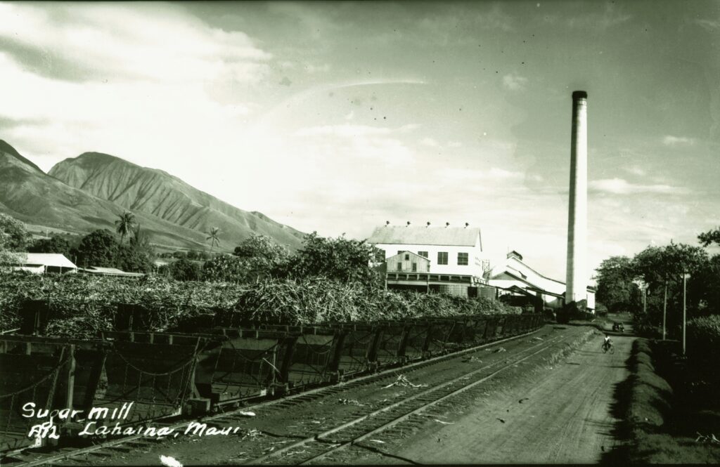
At the time in the Islands, sugar production was growing in scale; in addition to farming for food for the mission, the Lāʻie land was considered to have a good potential for growing sugar cane. In 1867, the first sugar cane was planted; in 1868 a mule-powered mill was installed.
Sugar played a central role in providing early members of the Church of Jesus Chris of Later-day Saints (Mormons) on the Lāʻie Plantation with income and financial sustainability.
In less than two years the little colony had grown to seven families from Utah, a Scotsman and 300-Polynesians. By 1871, a store, dairy and several frame houses had been built there was also a school that nearly 100 boys and girls attended regularly. During 1883, a substantial new meeting house was built and dedicated the King Kalākaua attended the dedication
In 1890, Kahuku Plantation Company and Oʻahu Railway and Land Company (OR&L) worked together to establish a railroad connecting the sugar industry facilities between Kahuku to the north and Kahana to the south – passing through Lāʻie. (This served as a common freight carrier until 1931.)
By 1895 the old sugar mill had stood idle almost six years. The cane was being processed by the Kahuku mill at a much cheaper price than the Lāʻie plantation could produce it.
By the turn of the century many changes had taken place in Lāʻie. The old mission home was gone, although a new one was in its place; the old sugar mill was no longer functioning; the cane crop was being processed at the Kahuku mill; 450-acres were planted in cane; the homes of the Polynesians had been removed from the sugarcane fields; 250 acres of rice was being cultivated by Chinese families. (Berge)
The Mormon Temple in Lāʻie – started in 1915 and dedicated on Thanksgiving Day 1919 – was the first such temple to be built outside of continental North America. The over 47,000-square-foot temple’s exterior is concrete made of crushed lava rock from the area and tooled to a white cream finish. It attracted more islanders from throughout the South Pacific.
When the Mormon missionaries bought Lāʻie, they hoped to create a gathering place where Native Hawaiian converts could settle, grow strong in their faith, and learn Western-styled industry. (Compton)
Today, the Temple, Brigham Young University – Hawaiʻi, Polynesian Cultural Center and a variety of other Mormon facilities and followers dominate the Lāʻie landscape.