Images of Old Hawaiʻi

  • Home
  • About
  • Categories
    • Ali’i / Chiefs / Governance
    • American Protestant Mission
    • Buildings
    • Collections
    • Economy
    • Missionaries / Churches / Religious Buildings
    • General
    • Hawaiian Traditions
    • Other Summaries
    • Mayflower Summaries
    • Mayflower Full Summaries
    • Military
    • Place Names
    • Prominent People
    • Schools
    • Sailing, Shipping & Shipwrecks
    • Voyage of the Thaddeus
  • Collections
  • Contact
  • Follow

April 23, 2022 by Peter T Young 2 Comments

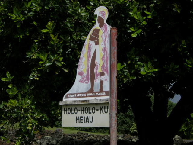
Holoholokū

Hānau ke aliʻi I loko o
Holoholokū, he aliʻi nui
Hānau ke kanaka I loko o
Holoholokū, he aliʻi no
Hānau ke aliʻi mawaho aʻe o H
Holoholokū ʻaʻohe aliʻi
he kanaka ia.

The child of a chief born in
Holoholokū is a high chief;
The child of a commoner born
in Holoholokū is a chief;
The child of a chief born outside
of the borders of Holoholokū
is a commoner.

The traditional name was Ka Lae o Ka Manu, which means the crest of the bird. Holoholokū appears to have been the ancient locality name.  (NPS)

Oral traditions tell of the sacred births of Kauaʻinui and Wailuanuihoʻano and the establishment of this area as a birthing site reserved for royalty. It is still considered as one of Hawaiʻi’s most sacred sites.  (Wailua Heritage Trail)

Holoholokū at Wailua on Kaua’i was one of two places in Hawai‘i specifically designated for the birth of high ranking children; the other site was Kūkaniloko near Wahiawa on Oʻahu.

Here all the kings of Kauaʻi were born, from earliest times to King Kaumualiʻi.  Aliʻi from other islands would also come here to give birth.

Kaumuali‘i was the only son of Kamakahelei and Kāʻeo (his mother Kamakahelei ruled the island when Captain James Cook made ‘contact’ in 1778.)  Kaumualiʻi was born the same year at Holoholokū. Kaumuali‘i became ruling chief of Kaua‘i upon the death of his parents.

It is said to be the oldest heiau on Kauaʻi and was named for a foster parent of Kawelo, son of Kauai’s ruling chief Mano-kalani-po and his wife Ka-wai-kini early in the 17th century.

Two boulders are within the heiau; the pōhaku hānau (birthstone) is actually two rocks.  Expectant mothers sat on the flat rock and rested her back on the other; when in use, the rocks were enclosed in a shelter and the rocks were covered with mats and kapa.

“… when an expectant mother of royal lineage was about to deliver her child, she would travel to the birthstone and squat on the ledge, leaning back against the upright section of the stone. After the birth, the mother and child were moved into a cave adjacent to the stone …“

“The mother remained in the cave with her child and retinue until she was able to travel; a booth or temporary shelter was built over the place. This was the sacred birthplace of the aliʻi or chiefs.”

“If the child really were a great chief, the heavens allegedly would burst forth with thunder and lightning, and there would be a heavy downpour of rain. A rainbow would arch over the area, with one end indicating the spot where the child had been born.”  (NPS)

A tradition describes how the piko (navel cord) of a newborn child was placed in the nearby Pōhaku Piko; if a rat stole the piko it was an omen that the child would grow up to be a thief, and allegedly the child was put to death. (NPS)

Another legend states that the newborn child was carried up a path to a boulder on the ridge, overlooking the river.  As the kahuna walked, he chanted of the arrival of the new chief.  (Joesting)

Within the walls of the heiau was a grass-thatched house of the kahuna.  “Bits of branch coral (indicative of sacredness) are scattered through the walls. Small, water-worn pebbles out on the earthen floor indicate the former presence of a house floor-pavement.”

“The west side of the heiau is bounded by a terrace and at the south end of this terrace, the south-west corner of the heiau, is a great horizontal ledge of stone, called the sacrificial stone.”

“Built out from the north side of this ledge is a little terrace, 9 feet square ….. I am certain the heiau of Ka-lae-o-ka-manu, or Holoholokū served in conjunction with the birth place, and that here the drum which would announce the news would be kept, as the drum of Kūkaniloko was kept in the near-by heiau.”  (Emery, 1933)

In December 1933, restoration of the Holoholokū heiau was completed by a team of volunteers led by Grove Farm director Henry Digby Sloggett, with Kapaʻa resident Charles Lono Kelekoma and Honolulu’s Bishop Museum providing technical expertise.   (TGI)

© 2022 Hoʻokuleana LLC

Filed Under: Ali'i / Chiefs / Governance, Hawaiian Traditions, Place Names Tagged With: Hawaii, Holoholoku, Kukaniloko, Kauai, Kamakahelei, Kaeo, Wailua, Kaumualii

April 17, 2022 by Peter T Young 3 Comments

ʻIliʻili Hānau o Kōloa

Ka ʻiliʻili hānau o Kōloa; ka nalu haʻi o Kāwā.
The reproducing pebbles of Kōloa; the breaking surf of Kāwā.

ʻIliʻili hānau o Kōloa (Birth Pebble of Kōloa) is the mother of rocks for Kaʻū district, referring to the porous pebbles found especially at the beach of Kōloa, Kaʻū district, on Hawaiʻi Island.

Such stones were supposed to grow from a tiny pebble to a good-sized rock and to reproduce themselves if watered once a week. Care had to be taken lest they be stepped upon or otherwise treated with disrespect.

Hence they were carefully wrapped in tapa and laid away on a high rafter of the house. At a child’s naming day or on other special occasions such as marriages, wars, and fishing expeditions they were taken down and arranged on ti leaves, together with awa root, upon a mat or table and their wisdom and blessing invoked.

Afterwards some member of the family would have a dream favorable or unfavorable to the project in hand and this was regarded as sent from the god.  (Beckwith)

These are beach worn pebbles. The interest attaching to them is derived from the belief still held by many natives with whom Emerson conversed with that they are of different sexes and beget off spring which increase in size and in turn beget others of their kind.

The males are of a smooth surface without noticeable indentations or pits. The females have these little pits in which their young are developed and in due time separate from their mothers to begin independent existence.

The ‘male’ stones are gray, basalt beach-worn pebbles having no pits or cavities. Most are flat and about an inch in size. The ‘female’ stones (a little bigger) are of the same material; however, they have small pits or cavities within which are very tiny basalt pebbles.

The “children” that are not in the “female” cavities and a less than an inch long.  (Bishop Museum)

William Ellis tells the following account from his brief visit there in 1824:

“We had not traveled far (from Hīlea) before we reached Nīnole, a small village on the sea shore, celebrated on account of a short pebbly beach called Koroa (Kōloa)”.

“(T)he stones of which were reported to possess very singular properties, among others, that of propagating their species.”

“The natives told us it was a wahi pana (place famous) for supplying … the stones for making small adzes and hatchets, before they were acquainted with the use of iron”.

“(B)ut particularly for furnishing the stones of which the gods were made, who presided over most of the games of Hawai‘i.

“Some powers of discrimination, they told us, were necessary to discover the stones which would answer to be deified.”

“When selected they were taken to the Heiau, and there several ceremonies were performed over them. Afterwards, when dressed, and taken to the place where the games were practiced, if the parties to whom they belonged were successful, their fame was established”.

“(B)ut if unsuccessful for several times together, they were either broken to pieces, or thrown contemptuously away.“

“When any were removed for the purpose of being transformed into gods, one of each sex was generally selected; these were always wrapped very carefully together in a piece of native cloth.”

“After a certain time, they said a small stone would be found with them, which, when grown to the size of its parents, was taken to the Heiau, or temple, and afterwards made to preside at the games.  We were really surprised at the tenacity with which this last opinion was adhered to”.

“Koroa [Kōloa] was also a place of importance in times of war, as it furnished the best stones for the slingers.”

“The natives told us it was a wahi pana (place famous) for supplying the black and white kōnane stone.”

“We examined some of the stones. The black ones appeared to be pieces of trap, or compact lava. The white ones were branches of white coral common to all the islands of the Pacific.”

“The angles of both were worn away, and a considerable polish given, by the attrition occasioned by the continual rolling of the surf on the beach.” (Ellis)

The ʻiliʻili from Kōloa were considered the best on the island of Hawaiʻi for hula ʻiliʻili.

© 2022 Hoʻokuleana LLC


Filed Under: Hawaiian Traditions, Place Names Tagged With: Punaluu, Hawaii, Hawaii Island, Konane, Hula, Iliili Hanau o Koloa, Iliili

April 15, 2022 by Peter T Young Leave a Comment

Hāpuʻu and Kalaʻihauola


Hiʻiaka, looking towards the uplands, where she saw Hāpuʻu and Kalaʻihauola – “I do not want you to say I did not acknowledge you, so here are the chanted regards from the traveler.” Then Hiʻiaka offered up this kanaenae (chant of praise.)

O Hāpuʻu and Kalaʻihauola
O women who dwell on the Koʻolau range
Residing upon the pathway
I offer this chant for those who pass that way.

Hāpuʻu and Kalaʻihauola were supernatural grandmothers of Piʻikea, wife of ʻUmi-a-Līloa.  They wanted to have a grandchild to take back to Oʻahu to raise, because the mother of Piʻikea, Laieloheloheikawai, belonged to Oʻahu. (Laieloheloheikawai sent Hāpuʻu and Kalaʻihauola to the Island of Hawaiʻi to bring back one of Piʻikea’s children.)  ʻUmi refused.

Then, people in the village started to die at night; the supernatural personages of Hāpuʻu and Kalaʻihauola murdered the people … this continued every night, the people dying without cause.

Piʻikea then said to ʻUmi-a-Līloa: “There is no other cause of death. My grandmothers, Hāpuʻu and Kalaihauola, did the killing. They were sent by my mother to bring one of our children, but you have withheld it, and that is why the people are murdered.”

Then, when Hāpuʻu and Kalaihauola were at the house with Piʻikea, the latter being pregnant with child, the old women slapped on Piʻikea’s knees and the child was delivered in front of one of the old women.

The child being a girl, it was taken away by the deities and lived in Oahu. Thus the child Kahaiaonui-a-Piʻikea, or Kahaiaonui-a-ʻUmi, became the adopted of Laielohelohekawai.  (Fornander)

“Within a few yards of the upper edge of the pass, under the shade of surrounding bushes and trees, two rude and shapeless stone idols are fixed, one on each side of the path, which the natives call ‘Akua no ka pali,’ gods of the precipice”.

“They are usually covered with pieces of white tapa, native cloth; and every native who passes by to the precipice, if he intends to descend, lays a green bough before these idols, encircles them with a garland of flowers, or wraps a piece of tapa round them, to render them propitious to his descent”.

“All who ascend from the opposite side make a similar acknowledgment for the supposed protection of the deities, whom they imagine to preside over the fearful pass. This practice appears universal for in our travels among the islands, we have seldom passed any steep or dangerous paths, at the commencement or termination of which we have not seen these images, with heaps of offerings lying before them.”  (Ellis, 1834)

“At the bottom of the Parre … offerings of flowers and fruit are laid to propitiate the Akua Wahini, or goddesses, who are supposed to have the power of granting a safe passage.” (Bloxam, 1826)

“… the old people said that their ancestors had been accustomed to bring the navel cords of their children and bury them under these stones to insure protection of the little ones from evil, and that these were the stone women …”  (Westerfelt)

The two stones, believed to embody two kupua goddesses, Hāpuʻu and Kalaʻihauola, on each side of Kalihi Stream, are also associated with the ‘E‘epa (small folks related to the Menehune,) that would cause rain if the proper offerings were not left near these stone.

“They (Hāpuʻu and Kalaʻihauola) were said to be mysterious people from this side of the valley of Nuʻuanu. They left Nuʻuanu with others of their kind because there was a war in Nuʻuanu and some fled.  Some settled in the uplands of Kalihi.”  (Joseph Poepoe; Cultural Surveys)

Mary Kawena Pukui states that the latter should be pronounced “Kala‘iola,” because of the word ola (‘life’) reflects that those who placed navel cords here were seeking life for their babies.   (pacificworlds)

The stones stood in an area of pools of spring water. One pool was icy cold, others warm, Hawaiian mothers brought their newborn babes to the spot and bathed them in the warm spring.  (Clarice Taylor, Honolulu Star Bulletin, August 18, 1954)

Travelers to the area placed lei and flowers upon the stones, at the same time asking the ʻEʻepa not to play tricks on them.  A favorite lei offering was made of the sweet smelling pala palai fern.

The pools marked the spot where the great god Kane struck the earth and brought forth water. It is called Ka puka wai o Kalihi, the water door of Kalihi.

The two famous stones were destroyed by bulldozers in October 1953 when the men first cleared the area for the approach road for the Wilson Tunnel.

“Their destruction was probably the cause of the drought which gripped this Island during the Fall months and the heavy rains which have been falling this summer (1954) and caused the Wilson Tunnel cave-in, the Hawaiians say.”  (Clarice Taylor, SB, August 18, 1954)

© 2014 Hoʻokuleana LLC

Filed Under: Hawaiian Traditions Tagged With: Hawaii, Oahu, Kalihi, Umi-a-Liloa, Kalaihauola, Hiiaka, Piikea, Hapuu

April 8, 2022 by Peter T Young Leave a Comment

Island Summits

He ‘Ohu Ke Aloha; ‘A‘ohe Kuahiwi Kau ‘Ole
Love is like mist; there is no mountaintop that it does not settle upon

“… as the sun shining in his strength dissipated the clouds, we had a more impressive view of the stupendous pyramidal Mauna Kea, having a base of some thirty miles, and a height of nearly three miles.  Its several terminal peaks rise so near each other, as scarcely to be distinguished at a distance.”

“These, resting on the shoulders of this vast Atlas of the Pacific, prove their great elevation by having their bases environed with ice, and their summits covered with snow, in this tropical region, and heighten the grandeur and beauty of the scene, by exhibiting in miniature, a northern winter, in contrast with the perpetual summer of the temperate and torrid zones below the snow and ice.”

“The shores along this coast appeared very bold, rising almost perpendicularly, several hundred feet, being furrowed with many ravines and streams. From these bluffs, the country rises gradually, for a few miles, presenting a grassy appearance, with a sprinkling of trees and shrubs.”

“Then, midway from the sea to the summit of the mountain, appeared a dark forest, principally of the koa and ʻōhia, forming a sort of belt, some ten miles in breadth-the temperate zone of the mountain.”  (Bingham at first sight of the Islands, 1820)

And when you think about high elevation places in the Hawaiian islands, of course you have to talk about that basic dichotomy between the lower elevation places where people live.

And in old times, the lower elevations would have been called the Wao Kanaka. Wao being a word that means “zone” and “Kanaka” being a person. So the Wao Kanaka is a zone in which people belong.

When you rise above that zone, you enter into a realm in which all of the living things there are not there because of human activity. They flourish as the result of the activity of the gods, or the Akua. And so that zone is called the Wao Akua. And the transition from Wao Kanaka to Wao Akua is not taken lightly.  (Gon)

The Islands’ peaks are considered the piko (summit or center of the land) and are considered sacred.  The places upon which clouds nestle are considered wao akua, the realm of the gods.  Clouds cover the actions of the gods while they walk the earth. The higher the piko, the closer to heaven, and the greater the success of prayers. (Maly)

Let’s look at Hawaiʻi’s peaks, the highest point on each Island as we move down the Island chain.

Niʻihau – Pānīʻau (1,281-feet)

Ni‘ihau was formed from a single shield volcano approximately 4.89-million years ago, making it slightly younger in age than Kaua‘i. It is approximately 70-square miles or 44,800-acres.  It’s about 17-miles west of Kauaʻi.

Pānīʻau, the island’s highest point, is 1,281-feet; approximately 78% of the island is below 500-feet in elevation.   Located inside Kauai’s rain shadow, Ni‘ihau receives only about 20 to 40-inches of rain per year.  Ni‘ihau has no perennial streams.  (DLNR)

Kauai – Kawaikini (5,243-feet)

Geologically, Kauai is the oldest of the main inhabited islands in the chain. It is also the northwestern-most island, with Oʻahu separated by the Kaʻieʻie Channel, which is about 70-miles long. In centuries past, Kauai’s isolation from the other islands kept it safe from outside invasion and unwarranted conflict.

Near the summit (Kawaikini) is Waiʻaleʻale; in 1920 it passed Cherrapunji, a village in the Khasi hills of India, as the wettest spot on Earth (recording a yearly average of 476-inches of rain.)

Oʻahu – Kaʻala (4,025-feet)

The Waiʻanae Mountains, formed by volcanic eruptions nearly four-million years ago, have seen centuries of wind and rain, cutting huge valleys and sharp ridges into the extinct volcano.  Mount Kaʻala, the highest peak on the island of Oʻahu, rises to 4,025-feet.

Today, only a small remnant of the mountain’s original flat summit remains, surrounded by cliffs and narrow ridges. It’s often hidden by clouds.

Molokai – Kamakou (4,961-feet)

The island was formed by two volcanoes, East and West, emerging about 1.5-2-million years ago.  The cliffs on the north-eastern part of the island are the result of subsidence and the “Wailua Slump” (a giant submarine landslide – about 25-miles long that tumbled about 120-miles offshore – about 1.4-million years ago.)

Kamakou is part of the extinct East Molokai shield volcano, which comprises the east side of the island.   It and much of the surrounding area is part of the East Maui Watershed partnership and the Kamakou Preserve.  A boardwalk covers part of the rainforest and bog to protect the hundreds of native plants, birds, insects and other species there.

Lānai – Lānaihale (3,337-feet)

The island of Lānai was made by a single shield volcano between 1- and 1.5-million years ago, forming a classic example of a Hawaiian shield volcano with a gently sloping profile.  (SOEST)  The island of Lānai is about 13-miles long and 13-miles wide; with an overall land area of approximately 90,000-acres, it is the sixth largest of the eight major Hawaiian Islands.

“At the very summit of the island, which is generally shrouded in mist, we came upon what Gibson (an early (1861) Mormon missionary to the islands) called his lake – a little shallow pond, about the size of a dining table.  In the driest times there was always water here, and one of the regular summer duties of the Chinese cook was to take a pack mule and a couple of kegs and go up to the lake for water.”  (Lydgate, Thrum)

Maui – Haleakalā (10,023-feet)

Haleakalā was thought to have been known to the ancient Hawaiians by any one of five names: “Haleakalā,” “Haleokalā,” “Heleakalā,” “Aheleakalā” and “Halekalā.” (Hawaiʻi National Park Superintendent Monthly Report, December 1939)

Haleakalā is best known in stories related of the demi-god Māui; he is best known for his tricks and supernatural powers. In Hawaiʻi, he is best known for snaring the sun, lifting the sky, discovering the secrets of fire, fishing up the islands and so forth.  (Fredericksen)

Kahoʻolawe – Lua Makika (1,477-feet)

Kahoʻolawe is the smallest of the eight Main Hawaiian Islands, 11-miles long and 7-miles wide (approximately 28,800-acres;) it is seven miles southwest of Maui.  The highest point on Kahoʻolawe is the crater of Lua Makika at the summit of Puʻu Moaulanui, which is about 1,477 feet above sea level.

Located in the “rain shadow” of Maui’s Haleakalā, rainfall has been in short supply on Kahoʻolawe.  However, nineteenth century forestry reports mentioned a “dense forest” at the top of Kahoʻolawe.  Historically, a “cloud bridge” connected the island to the slopes of Haleakalā.  The Naulu winds brought the Naulu rains that are associated with Kahoʻolawe (a heavy mist and shower of fine rain that would cover the island.)

Hawaiʻi – Mauna Kea (13,796-feet)

Nani Wale ʻO Mauna Kea, Kuahiwi Kūhaʻo I Ka Mālie (Beautiful is Mauna Kea, standing alone in the calm) expresses the feeling that Mauna Kea is a source of awe and inspiration for the Hawaiian people. The mountain is a respected elder, a spiritual connection to one’s gods.   (Maly)

A significant pattern archaeologists note in their investigations is the virtual absence of archaeological sites at the very top of the mountain. McCoy states that the “top of the mountain was clearly a sacred precinct that must, moreover, have been under a kapu and accessible to only the highest chiefs or priests.”  (Maly)

ʻĀina mauna, or mountain lands, reflects a term used affectionately by elder Hawaiians to describe the upper regions of all mountain lands surrounding and including Mauna Kea.  (Maly)

© 2022 Hoʻokuleana LLC

Filed Under: Hawaiian Traditions, General Tagged With: Kaala, Kamakou, Hawaii, Kawaikini, Hawaii Island, Paniau, Oahu, Mauna Kea, Molokai, Lanaihale, Haleakala, Summits, Maui, Kahoolawe, Kauai, Lanai, Niihau

April 5, 2022 by Peter T Young Leave a Comment

Kailua-Kona in 1819

The expedition sailed from Toulon on the 17th of September 1817 … “Finally, (they) arrived at Havre on the 15th, (November 1820) … The duration of the voyage was therefore three years and two months nearly”.

“The principal object of the expedition commanded by Captain Freycinet, was the investigation of the figure of the earth, and of the elements of terrestrial magnetism; several questions of meteorology had also been suggested by the Academy as worthy of attention.”

“Although geography certainly formed but a secondary object in the voyage, it was natural to anticipate that so many experienced and zealous officers, well provided with excellent instruments, would not circumnavigate the globe without making some valuable additions to the existing tables of latitude and longitude.” They came to the Islands in August 1819.

“On the 5th of April 1819, the Uranie sailed from Guam; she cast anchor at Owhyhee, the largest of the Sandwich Islands, on the 8th of August: on the 16th she touched at Mowhee; on the 26th at Woahoo; and on the 30th, finally quitted that Archipelago for Port Jackson”. (Arago)

“It was on the 6th of August that we discovered the island of Owhyhee: we were only a short distance from it; and the land, which we expected to see of a prodigious height, appeared to us as of very moderate elevation.”

“An island which recalled so many unpleasant recollections, necessarily excited our attention; and every one fixed his eye on it. On a sudden, the thick clouds separating, which covered its regularly formed sides and enormous base; Mowna Kah stood, majestically before us ….”

“Karakakooa harbour is spacious and safe; the high mountains which protect it from the winds which blow most generally, namely, Cape Kovvrovva to the north, and Cape – to the south, prevent the sea from ever being very rough. The beach is good, and some buildings, and two considerably projecting piers, offer a secure shelter for shipping.”

“Kayerooa is the largest, most important, and most populous town of Owhyhee … The town of Kayerooa is of considerable extent; but the houses, or rather the huts, are at such distances from each other …”

“… particularly on the descent of the hill, as not to be at all connected with the part in the plain, in which there are some small beaten paths, which may pass as tolerable representations of streets and alleys.”

“There are some houses built of stone, cemented with mortar; the others are made of thin deals, with mats or leaves of palm-trees, closely tied together and made impenetrable to wind and rain.”

“The roofs are in general covered with sea-weed, which makes them wonderfully strong; while they are also very durable, owing to a few beams closely fitted and fastened with cords of the plantain tree.”

“The huts of Owhyhee appear to me the best that we have seen since we have been in these semi-barbarous regions. Almost the whole of them have only one apartment, ornamented with mats, calebashes, and some country cloths.”

“In that room fathers, mothers, boys, girls, and sometimes even hogs and dogs, all sleep together pele-mele: there the mothers offer their daughters to strangers; there the children learn, almost as soon as they are born, what they ought scarcely to know when they are grown up …”

“Two or three buildings, as seen from the roads (anchorage), have a good appearance, and make one rather regret that they are, as it were, solitary in the midst of ruins.”

“The most considerable is a storehouse distinguished by its white front from the other huts; it belongs to the King, who uses it as a sort of repository, without venturing to confide his treasures to its keeping; these he buries in cellars.”

“The second edifice is a morai, situated at the end of a jetty, projecting into the sea; the third is a house belonging to one of the principal chiefs of Riouriou, who had address enough, when he quitted the town, to get it consecrated (tabooed) in order to protect it from intruders and thieves.”

“I was given to understand, that whoever should endeavour to enter it, would be instantly put to death, and that the owner of the house was a very cruel and powerful man. The northern part of the town may perhaps consist of a hundred huts, most of which are only about three or four feet high, and six long ….”

“On reaching the shore, there is a large dock-yard directly opposite, in which a vessel was building, of forty tons burden. Near it are some sheds, which shelter from the rain and wind a prodigious number of canoes, both single and double, remarkably handsome and well finished.”

“They are made by means of an instrument called in this country toe, which may be compared to a carpenter’s adze, though much smaller, and fit to be used by one hand.”

“Our cabinet-makers do not polish the most costly furniture better; and without planes or any of the tools employed by our workmen, those of Owhyhee are capable of competing with the best artisans of Europe.”

“The inside of the bottom of their boats, as far as the thwarts, is painted black, and polished till it becomes very bright, by means of a yellow flower which is found all over the island.”

“The largest canoe was a single one, seventy-two feet long, and three in its greatest breadth. The threads with which the planks were sewed o=together and with which the other parts of the canoes and their outriggers were connected, were twisted and fastened with wonderful skill.”

“After visiting a great number of the houses of Kayerooa, where these people, whose existence is so monotonous and so peaceful, repose from their indolent toils, I directed my steps towards the Governor’s hut, as he had asked me to visit him.”

“It is small, but very clean, and tolerably well furnished; containing rather a handsome bed, two wicker chairs, some Indian cushions, and a great number of mats. …”

“The town of Kayerooa is situated at the foot of a high mountain which protects the anchorage from the North and North-West winds. From this mountain, particularly from the nearest declivity, the inhabitants derive the greater part of their subsistence.”

“It is really melancholy to see the extensive plain which surrounds it on both sides, uncultivated and despised. I cannot conceive how a people so characteristically idle and indifferent can neglect so fertile a spot, which would at once enrich and save them great fatigue and suffering …”

“… a few days’ labour would provide them subsistence for several months; and two years’ perseverance would secure to them for ever those valuable gifts, of which, on the summit of mountains, a violent storm or some other catastrophe may so easily deprive them. …”

“Our botanist, whose zeal augments with the difficulty and fatigue he encounters, has walked over the best part of the heights above the town.”

“He assures us, that vegetation was very powerful there, and that it would be very easy to conduct into the plain, by means of shallow canals, the waters which fertilize these summits, and are entirely lost to the inhabitants, whose means of subsistence are entirely derived from the lands which adjoin the sea. …”

“We left Owhyhee on the 15th of August, at four in the morning, with a very light breeze, which, however, freshened up during the morning.”

© 2022 Hoʻokuleana LLC

Ahuena_heiau_1816
Ahuena_heiau_1816

Filed Under: Economy, General, Hawaiian Traditions, Place Names Tagged With: Hawaii, Hawaii Island, Kona, Kailua-Kona, Timeline

  • « Previous Page
  • 1
  • …
  • 36
  • 37
  • 38
  • 39
  • 40
  • …
  • 101
  • Next Page »

Images of Old Hawaiʻi

People, places, and events in Hawaiʻi’s past come alive through text and media in “Images of Old Hawaiʻi.” These posts are informal historic summaries presented for personal, non-commercial, and educational purposes.

Info@Hookuleana.com

Connect with Us

  • Email
  • Facebook
  • LinkedIn
  • Twitter
  • YouTube

Recent Posts

  • ‘Hilo Walk of Fame’
  • Men of the Mission
  • Train Accident at Maulua Tunnel
  • Beyond the Boundaries
  • Napa Meets Hawaiʻi
  • Squirmin’ Herman
  • Drinking Smoke

Categories

  • General
  • Ali'i / Chiefs / Governance
  • Buildings
  • Missionaries / Churches / Religious Buildings
  • Hawaiian Traditions
  • Military
  • Place Names
  • Prominent People
  • Schools
  • Sailing, Shipping & Shipwrecks
  • Economy
  • Voyage of the Thaddeus
  • Mayflower Summaries
  • American Revolution

Tags

Albatross Al Capone Ane Keohokalole Archibald Campbell Bernice Pauahi Bishop Charles Reed Bishop Downtown Honolulu Eruption Founder's Day George Patton Great Wall of Kuakini Green Sea Turtle Hawaii Hawaii Island Hermes Hilo Holoikauaua Honolulu Isaac Davis James Robinson Kamae Kamaeokalani Kamanawa Kameeiamoku Kamehameha Schools Lalani Village Lava Flow Lelia Byrd Liliuokalani Mao Math Mauna Loa Midway Monk Seal Northwestern Hawaiian Islands Oahu Papahanaumokuakea Marine National Monument Pearl Pualani Mossman Queen Liliuokalani Thomas Jaggar Volcano Waikiki Wake Wisdom

Hoʻokuleana LLC

Hoʻokuleana LLC is a Planning and Consulting firm assisting property owners with Land Use Planning efforts, including Environmental Review, Entitlement Process, Permitting, Community Outreach, etc. We are uniquely positioned to assist you in a variety of needs.

Info@Hookuleana.com

Copyright © 2012-2024 Peter T Young, Hoʻokuleana LLC


Loading Comments...