Images of Old Hawaiʻi

  • Home
  • About
  • Categories
    • Ali’i / Chiefs / Governance
    • American Protestant Mission
    • Buildings
    • Collections
    • Economy
    • Missionaries / Churches / Religious Buildings
    • General
    • Hawaiian Traditions
    • Other Summaries
    • Mayflower Summaries
    • Mayflower Full Summaries
    • Military
    • Place Names
    • Prominent People
    • Schools
    • Sailing, Shipping & Shipwrecks
    • Voyage of the Thaddeus
  • Collections
  • Contact
  • Follow

September 29, 2026 by Peter T Young Leave a Comment

Lake Waiau

Mauna Kea falls in the senior line genealogy. (Maly)

Former Queen Emma, widow of the late Alexander Liholiho Kamehameha (IV,) and David Kalakaua were in competition for the position of monarch of Hawai’i.

Both of them needed to prove their connection to the senior line and connect back to a wahi pana (celebrated and storied places). Kalakaua went to Kanaloa-Kahoʻolawe to bathe in the waters of the ocean god Kanaloa.

Emma went to the top of Mauna Kea to bathe in the waters of Waiau. The ceremony was to cleanse in Lake Waiau at the piko of the island.

The water caught at Lake Waiau was considered pure water of the gods much like the water caught in the piko of the kalo leaf, the nodes of bamboo or the coconut and is thought of as being pure. (Maly, Mauna-a-Wakea))

Papa is a goddess of earth and the underworld and mother of gods. Wakea is god of light and of the heavens who “opens the door of the sun”. (Beckwith)

“In the genealogy of Wakea it is said that Papa gave birth to these Islands. Another account has it that this group of islands were not begotten, but really made by the hands of Wakea himself.” (Malo)

Waiau is named for the mountain goddess, Waiau (Ka piko o Waiau), and home of the moʻo (water-form) goddess Moʻo-i-nanea.

It is a place where piko of newborn children were taken to ensure long life; and from which “ka wai kapu o Kane” (the sacred water of Kane) was collected. (Maly)

Lake Waiau, located at the 13,020-foot elevation, is on the Island of Hawaii, near the summit of Mauna Kea.

The ancient Hawaiians believed that spirits traveled to and from the spirit world through Lake Waiau, which had ‘no bottom.’ (Actually, the lake has been measured in modern times at 10 feet deep.) The lake freezes over in winter. (Allen)

Lake Waiau is a ‘perched’ water body, in which water is held in a depression by an impermeable substrate of layers of silty clay, interbedded with ash layers, and it has been proposed that permafrost also underlies the lake. It has also been suggested that permafrost surrounds the lake and provides a catchment that directs water into the lake. (USGS)

In 1830, Hiram Bingham and Kauikeaouli (Kamehameha III) ascended Mauna Kea and stopped at Lake Waiau – Bingham noted, “In the morning we proceeded slowly upwards till about noon, when we came to banks of snow, and a pond of water partly covered with ice.”

“In his first contact with a snow bank, the juvenile king seemed highly delighted. He bounded and tumbled on it, grasped and handled and hastily examined pieces of it, then ran and offered a fragment of it in vain to his horse.”

“He assisted in cutting out blocks of it, which were wrapped up and sent down as curiosities to the regent and other chiefs, at Waimea, some twenty-eight miles distant.”

“These specimens of snow and ice, like what are found in the colder regions of the earth, excited their interest and gratified their curiosity, and pleased them much; not only by their novelty, but by the evidence thus given of a pleasant remembrance by the youthful king.”

“After refreshing and amusing ourselves at this cold mountain lake, we proceeded a little west of north, and soon reached the
lofty area which is surmounted by the ‘seven pillars’ which wisdom had hewed out and based upon it, or the several terminal peaks near each other, resting on what would otherwise be a somewhat irregular table land, or plain of some twelve miles circumference.” (Hiram Bingham)

Others made the ascent, “(T)hrough the sliding, weathered lava and cinders, to the pass to the right of the summit cone, and down the slope of the shoulder of the mountain wherein nestles the surprise of Mauna Kea – Lake Waiau.”

“Here, as the sun dipped behind the blue waters of the Pacific, curving up to meet it, we gazed with astonished eyes upon a tiny emerald gem, glacier made in some past time, set in a niche in the arid side of Mauna Kea.”

“We pitched our tent hurriedly by the green, cold lake, built a fire in the whipping trade wind, with its chilly bite, ate an early supper, and retired like packed sardines between our blankets. We were in an arctic zone under a tropic sky.”

“Taking our last look across the lake, we saw the image of fair Venus, streaming in white and shimmering light across the tiny, rippling waves. A thousand jewels glittered in the reflected phantom light of our neighbor planet. The next morning, ice over a half-inch thick was found in the gravel bar about the lake.” (Daingerfield, Paradise of the Pacific, December 1922; Maly)

Another noted, “At last, about 3 PM, we clambered over the rim of a low crater west of the central cones, and saw before us the famous lakelet of Waiau, near which we camped.”

“It is an oval sheet of the purist water, an acre and three quarters in extent, surrounded by an encircling ridge from 90 to 135 feet in height, except at the northwest corner, where there is an outlet, which was only two feet above the level of the lake at the time of our visit.”

“The overflow has worn out a deep ravine, which runs first to west and then to the southwest. A spring on the southern side of the mountain, called “Wai Hu”, is believed by the natives to be connected with this lake.”

“The elevation of Waiau is at least 13,050 feet, which is 600 feet higher than Fujiyama. There are few bodies of water in the world higher than this, except in Thibet or on the plateau of Pamir. No fish are found in its waters, nor do any water-fowl frequent its margins.” (Alexander, Pacific Commercial Advertiser, September 14, 1892)

“Lake Waiau … is the highest lake within the boundaries of the Pacific Ocean Basin. The southern rim of the depression containing the lake is a low segment of a cinder cone, Pu‘u Waiau, on which rests moraine of the latest period of glaciation.”

“The lake water is perched on a layer of silt and mud washed into the basin from the sides of the cone and from the glacial moraine. … The lowest point of the rim is on the western side, where the lake water occasionally overflows into the headwaters of Pohakuloa Gulch.”

“The water is derived entirely from precipitation and runoff from the edges of the basin.” (Geology and Groundwater Resources of the Island of Hawaii, Stearns & Macdonald, 1946)

© 2026 Hoʻokuleana LLC

Lake_Waiau-Paradise_of_the_Pacific-Dec_1922
Lake-Waiau-Huli Ka Lima
Lake_Waiau-USGS
Lake_Waiau-Huli Ka Lima
Lake_Waiau_person
Lake_Waiau_outlet
Lake_Waiau
Lake Waiau on September 26, 2013
Lake-Waiau

Filed Under: General Tagged With: Hawaii, Hawaii Island, Mauna Kea, Lake Waiau

October 30, 2025 by Peter T Young 1 Comment

Kaʻohe

Looking at land divisions on the Island of Hawaiʻi, “the common ahupuaʻa is found to be a strip say 1,000-feet average width, and running from the seashore, not by any means to the top of the mountains, but to the zone of timber land that is generally exists between 1,700 and 5,000-feet line of elevation. The ordinary ahupuaʻa extends from half a mile to a mile into this belt.”

“Then there are the large ahupuaʻa which are wider in the open country than the others, and on entering the woods expand laterally so as to cut off the smaller ones, and extend toward the mountain till they emerge into the open interior country not however to converge to a point at the tops of the respective mountains.”

“Only a rare few reach those elevations, sweeping past the upper ends of all the others, and by virtue of some privilege in bird-catching, or some analogous right, taking the whole mountain to themselves.”

“Thus Mauna Loa is shared by three great lands, Kapapala and Kahuku from Kaʻū, and Humuʻula from Hilo. Possibly Keauhou from Kona may yet be proved to have had a fourth share.”

“The whole main body of Mauna Kea belongs to one land from Hāmākua, viz., Kaʻohe, to whose owners belonged the sole privilege of capturing the ʻuaʻu, a mountain-inhabiting but sea-fishing bird.” (Kaʻohe translates to ‘bamboo;’ the name may relate to a bamboo water carrier.)

“High up on its eastern flank, however, stretched the already mentioned land of Humuʻula, whose upper limits coincide with those of the māmane, a valuable mountain acacia, and which, starting from the shore near Laupāhoehoe, extends across the upper ends of all other Hilo lands to the crater of Mokuʻāweoweo.”

“These same lands generally had the more extended sea privileges. While the smaller ahupuaʻa had to content themselves with the immediate shore fishery extending out not further than a man could touch bottom with his toes …”

“… the larger ones swept around outside of these, taking to themselves the main fisheries much in the same way as that in which the forests were appropriated.”

“Concerning the latter, it should here be remarked that it was by virtue of some valuable product of said forests that the extension of territory took place.”

“For instance, out of a dozen lands, only one possessed the right to kalai waʻa, hew out canoes from the koa forest. Another land embraced the wauke and olona grounds, the former for kapa, the latter for fish line.” (Lyons, The Islands, July 9, 1875)

“From the mass of evidence taken we find that in ancient time the main value of the land of Kaʻohe was the uwaʻo, a sea-bird, whose habitat was the dry, rocky and elevated portion of the mountain.” (Appeal from Boundary Commissioner, May 31, 1892)

Kaʻohe is an irregular ahupua‘a because it only occupies a narrow (and relatively resource-poor) band along the coast where most of the residents would have lived.

But as Kaʻohe ascends the eastern slope of Mauna Kea and emerges above the forest near 6,000-feet in elevation, it expands to occupy the entire summit region. The uplands of Kaʻohe would have contained few food resources beyond ground-nesting birds.

The primary evidence of pre-contact human utilization of Kaʻohe’s vast mountain region is the adze quarry, which would have provided Kaʻohe with a valuable resource to exchange with other ahupua‘a. (Mills)

The adze quarry area was “the largest workshops in the world for making of stone tools.” (Kenneth Emory) It covers an area of roughly 7 ½-square miles on the south slope of Mauna Kea. The main activity was concentrated in a zone that is 1-to-1½ miles wide between the 11,000 and 12,400 ft. elevation.

The landscape is dotted with numerous cinder cones, the principal one of which in the quarry area is Puʻu Koʻokoʻolau. The upper slopes of Mauna Kea have been described as a stony alpine desert. There is little vegetation and the ground surface has the appearance of a desert pavement.

Kaʻohe effectively crosses and includes all regions going from the sea to the summits of Mauna Kea and Mauna Loa. Some of the general regions include (from top to bottom:)

Kuahiwi – the mountain top, which is too high in elevation for heavy vegetation to grow. It has strong winds and extreme climates (sometimes very hot and sometimes very cold.)

Kualono – the region near the mountain top. Likewise, very few plants and animals live here. Māmane and naio (hardwoods) are the only hardy trees to grow at this height.

Waomaʻukele – the region named for the wet, soggy ground. The main trees that live in this area are the koa and ʻōhiʻa. This area was located in the rain belt of the island, especially on the koʻolau side of each island.

Waoakua – the forested region, the realm of the god and where the rain forest begins. This sacred area was kapu to most kānaka.

Waokānaka – where kānaka live and farm the land. Wood was harvested for tools, weapons and canoes; many other useful things for everyday living were gathered here.

Kula – the upland plain or open country. Pili was harvested and used mostly for thatching hale (houses).

Kahakai – the edge of the ocean. Here ʻākulikuli, with succulent green leaves, resists wind and salt water. Its leaves contain a special chemical that acts like a natural steroid.

© 2025 Hoʻokuleana LLC

Filed Under: Place Names Tagged With: Hamakua, Mauna Kea, Kaohe, Hawaii, Hawaii Island, Mauna Loa

August 18, 2025 by Peter T Young Leave a Comment

Waikoloa

“It was the same from Hawaiʻi to Kauai –
no name was given without some reason.”
(Kamakau)

In old Hawaiʻi, it was the nature of ‘place’ that shaped the practical, cultural and spiritual view of the Hawaiian people.  In ancient times, the naming of a place was not a task to be undertaken lightly, for the Hawaiians recognized the power inherent in a name.

In giving a name to a piece of land, whether it be an island, a hill or a rocky headland, the inhabitants of ancient Hawaiʻi were placing a part of themselves on the landscape.  (Reeve)

Place names are a reaffirming link, not only to the land itself, but to all the events, both legendary and historic, which had taken place on that land and to the ancestors who had lived on and were now buried within it.

Place names are often descriptive of: (1) the terrain, (2) an event in history, (3) the kind of resources a particular place was noted for or (4) the kind of land use which occurred in the area so named. Sometimes an earlier resident of a given land area was also commemorated by place names.  (Kepa Maly)

Place names matter, and depending on your spelling or diacritical notations, you may be speaking of different places, with the same letter sequence.  Take, for instance,

Waikoloa (wai-kō-loa – the name of a wind (cold northwest wind; literally: water pulling far)
Waikoloa (wā‘i-ko‘-loā; wai-koloa) – literally: (wild) duck water

Honi aku i ke ala o ka mau ‘u
Ike ala o ke kupukupu,
E lino ‘ia ‘ana e ka Waikoloa

Sniff the scent of the grasses
The fragrance of the kupukupu ferns
That are twisted about by the Waikoloa wind (Kamakau)

“The region of Lālāmilo was named for the young chief Lālāmilo, grandson of Kanakanaka, an expert lawai‘a hī-‘ahi (deep sea tuna lure fisherman) and Pilia-mo‘o, a powerful priestess and ‘ōlohe. Kanakanaka and Piliamo‘o were the parents of Nē‘ula (a fishing goddess), and she married Pu‘u-hīna‘i a chief of the inlands, and they in turn were the parents of Lālāmilo.”

“Kanakanaka’s sister was the wind goddess, Waikōloa, for whom the lands are now named.” (Kepa Maly)

“Although the NEern part of the bay which (the whole or part) is call’d Toe-yah-ya [Kawaihae] looks green & pleasant, yet as it is neither wooded or hardly any signs of culture, & a few houses …”

“… it has certainly some defect, & does not answer the purposes of what the natives cultivate. The s part appear’d rocky & black, & partakes more of the nature of the land about Karakakooa [Kealakekua].” (Cook’s Journal by King, Feb 6, 1779; Maly)

In March 1779, while sailing north from Kealakekua, Cook’s ships passed the South Kohala shoreline and King compared the southern section of Kohala to the arid shore of Ka‘ū. He also reported that there appeared to be few residents in the area around Kawaihae. (Maly)

“We now come to Ko-Harra [Kohala] the NW & last district. It is bounded by two tolerable high hills, & the Coast forms a very extensive bay call’d Toe Yah-Yah, in the bottom of which is foul Corally ground, & there was no approaching it; in the head of the bay as far as we could judge distant the Country look’d tolerably, but the s side is partook of the same nature as Kao [Kau] …”

“… & along the NE side of the bay close to which we Sail’d, it is very little Cultivated, & we saw but few houses; the Peoples appearance shewd that they were the lowest Class that inhabited them…” (Cook’s Journal by King; Maly)

“The climate of this district is, upon the whole, unpleasant, particularly at Waimea, in consequence of the trade-wind, which is exceedingly strong, bringing with it a mist towards sunset. This wind rushes furiously down between the mountains which bound the valley of Waimea, and becomes very dangerous to shipping in the bay.”

“It is called by the natives ‘mumuku,’ and is foretold by them from an illuminated streak that is seen far inland. This is believed to be caused by the reflection of the twilight on the mist that always accompanies the mumuku.” (Wilkes, Vol IV, 1845)

Waimea is “a ‘Kalana’ or ‘‘Okana,’ a land division which in ancient times was treated as a sub-district, smaller than the moku o loko, yet comprised of a number of smaller lands that contributed to its wealth.”

“The lands and resources subject to the Kalana of Waimea included, but were not limited to, ‘Ōuli, Wai‘aka, Lālāmilo, Puakō, Kalāhuipua‘a, ‘Anaeho‘omalu, Kanakanaka, Ala‘ōhi‘a, Paulama, Pu‘ukalani (Pukalani), Pu‘ukapu, and Waikōloa.” (Kepa Maly)

“In the 1840s and 1860s, elder native witnesses described these various lands as ‘‘ili,’ or land divisions of lower status than ahupua‘a, which fell under the jurisdiction of the chiefs of Waimea.”

“Understanding this difference in the status of the land divisions of the Waimea region helps explain why lands such as ‘Anaeho‘omalu and Kalāhuipua‘a have no upland agricultural resources; and why Waikōloa and all the other lands extending north from it, except for Lālāmilo and ‘Ōuli, have no ocean frontage.” (Kepa Maly)

“Waikōloa and its smaller land areas shared a unique relationship with the Kalana of Waimea in ancient and early historic times.”

“In 1903, Parker Ranch, under the direction of A.W. Carter, purchased the land of Waikōloa, in which are situated the smaller land areas of Waiki‘i and Ke‘āmoku. By 1904, Parker Ranch began upgrading and developing the Waiki‘i and Ke‘āmoku stations.” (Kepa Maly)

“The Waiki‘i Village was under construction by 1909, and by 1918, over 2,000 acres of corn, hay, and other feed crops; and potato fields, tree farms and a fruit orchard had been planted.”

“The ranch also developed turkey, chicken and pig farms on the land. With the blossoming and fruiting of Waiki‘i upon the mountain landscape, there came also, people from the far corners of the earth.” (Kepa Maly)

Now head over to the east side of Mauna Kea … and you have Waikoloa (Duck Ponds).

The ‘pond’ reference helps identify this as the other translation and place name related to the Koloa – the Hawaiian Duck. This area has some shallow pools called the Duck-Ponds [Wai-koloa], from the quantity of these birds frequenting them.  (Maly)

Koloa are medium-sized (20 inches long) ducks with variable mallard-like plumage. Male Koloa-maoli resemble male mallards in eclipse plumage but have a dark chestnut breast. Dusky green heads on male Koloa rarely appear on other than first-year birds.

Female Koloa-maoli are similar to female mallards but are ruddier and with green rather than blue speculums (colored patch on their secondary wing feathers).

Koloa-maoli, termed simply Koloa, differ chiefly from their nearest relative, the Laysan duck, by their larger size, less regularly barred retrices, less reddish color, and lack of white around the eye.

The first mention of Koloa on the island of Hawai‘i seems to be that of Wilkes who wrote under date of January 11, 1841 that members of the Wilkes Exploring Expedition observed “an open space in the woods, near some shallow pools called the Duck-Ponds, from the quantity of these birds frequenting them.” (Wilkes)

Some 35 years later, during a brief stop-over by the Challenger Expedition, one of the Expedition members, Campbell, wrote that they “started many a wild duck … every hollow being under water” . (Banko, 1987)

Observers before 1900 recorded the Koloa as common and widespread, though becoming scarcer, in freshwater habitats on all of the major Islands. (Banko)

© 2025 Ho‘okuleana LLC

Filed Under: Place Names Tagged With: Waikoloa Ponds, Hawaii, Waimea, Mauna Kea, WaIkoloa

August 8, 2025 by Peter T Young Leave a Comment

Kanakaleonui

Mauna Kea, like Hawai‘i’s other older volcanoes, Hualālai and Kohala, has evolved beyond the shield-building stage, as indicated by:

  • the very low eruption rates compared to Mauna Loa and Kīlauea;
  • the absence of a summit caldera and elongated fissure vents that radiate its summit;
  • steeper and more irregular topography (for example, the upper flanks of Mauna Kea are twice as steep as those of Mauna Loa); and
  • different chemical compositions of the lava. (USGS)

Mauna Kea’s peaceful appearance is misleading. The volcano is not dead. It erupted many times between 60,000 and 4,000 years ago, and some periods of quiet during that time apparently lasted longer than 4,000 years. Given that record, future eruptions seem almost certain. (USGS Volcano Watch)

Pu‘u Kanakaleonui is one of the younger cones of the Laupāhoehoe Volcanics and is less than 13,000 years in age. (USGS)  Kanaka-Leo-Nui (loud-voiced person) “was the name of a retainer of ʻUmi-a-Līloa, a chief who is said to have had a house at the top of Mauna Kea with doors facing each of the six districts of Hawaiʻi.”

“If the chief wanted the Hilo people to bring supplies, he called from the Hilo door to Kanaka-leo-nui, who shouted out the orders from the top of the hill bearing his name.” (Hawaiian Place Names)

About the time Columbus was crossing the Atlantic, ʻUmi a Līloa (‘Umi, son of Līloa), was famous in Hawaiian history for being the first aliʻi (chief) to unify Hawaiʻi Island under a singular rule.

ʻUmi was a religious chief and was known to have erected a number of ahu (shrines) throughout the ʻāina mauna (mountain lands) to make offerings to the akua. After unifying the island, ʻUmi a Līloa chose to live in the ʻāina mauna with his people rather than returning to the lower ahupuaʻa (land divisions) where kānaka typically lived.

“Umi was a trail builder …. Where the a-a was level, his men marked their way across it by smooth going. Where there were depressions in it, they were filled up to the general level, much as a modern engineer would fill them.”

“Where there were hillocks to be crossed, these were cut away if not too high and passed over in a straight line if their altitude forbade grading.” (Sol Sheridan, Mid Pacific Magazine, Oct 1912)

Pu‘u Kanakaleonui is one of the younger cones of the Laupāhoehoe Volcanics and is less than 13,000 years in age. The dark-colored deposit partly surrounding and mantling Pu‘u Kanakaleonui consists of tephra and ejecta blocks of lava mostly 10 to 50 cm in diameter but as large as 3 m long.

Some of the ejecta are from underlying lava flows that were erupted more than 65,000 years ago from the Hāmākua Volcanics. The light-colored surface below the cone consists of lava flows that are not mantled by the explosive tephra and blocks. (USGS)

The next eruption could take place anywhere on the upper flanks of the volcano. As Mauna Kea evolved from its early shield stage (equivalent to Kīlauea and Mauna Loa today) to its present post-shield stage, the volcano lost its rift zones. Consequently, the post-shield eruptions are not concentrated along narrow zones but instead are scattered across the mountain.

A prominent cinder cone will probably be constructed at each vent. The cinder cones responsible for the ‘bumpy’ appearance of Mauna Kea’s surface. The cones were built during the latest eruptive period 6,000-4,000 years ago. The next eruption will likely produce a similar cone.

For example, the most recent eruptive period, 6,000-4,000 years ago, involved eight vents on the south flank of the volcano between Kala‘i‘eha cone (near Humu`ula) and Pu‘ukole (east of Hale Pōhaku). During this same period, eruptions took place on the northeast flank at Pu‘u Lehu and Pu‘u Kanakaleonui.

Lava from Pu‘u Kanakaleonui flowed more than [12 miles] northeastward, entering the sea to form Laupāhoehoe Point. (USGS Volcano Watch)

“[Right back [of the double Hill Holei Kanakaleonui], there is a Hawaiian graveyard. They used to bury there. When they go up and make their adze, and the Hawaiians die up there, they had a little … above Kanakaleonui, in between Red Hill and Kanakaleonui.” (John “Johnny” Ah San Oral History Interview with Kepā Maly)

With the exception of the possible adze maker interments, the apparent restriction of the higher elevation burials to the apex of cinder cones is in sharp contrast to many of the burials found at Kanakaleonui, a well-known burial center located not too far outside of the Science Reserve, just below Pu‘u Mākanaka and the summit plateau.

On current evidence there are more burials in the general environs of Kanakaleonui than probably exist higher on the mountain, possibly on all of the summit plateau.  (AIS Mauna Kea Science Reserve)

The disproportionate number of burials in the environs of Kanakaleonui suggests that the edge of the plateau might have been a major social boundary, with the area below reserved for commoners and the plateau for persons of higher social status (chiefs and priests).

If the very top of the cones were reserved for higher status individuals and the ground below for commoners, then Kanakaleonui must have both.  (AIS Mauna Kea Science Reserve)

Laupāhoehoe is the true ‘Umi’s Trail. ‘Umikoa one, that’s when they go up and they turn around, and they meet ‘Umi Trail. (Mr. Ah San noted that Laupähoehoe-Waipunalei Trail runs up the mountain from near the heiau of ‘Umi – recorded as being named Mämala or Ha‘akoa.)

The trail runs mauka past Ke-ana-kolu (The-three-caves), which was a known resting spot on the trail up the mountain. The caves are approximately one-mile mauka from the old Keanakolu ranch house. (Maly)

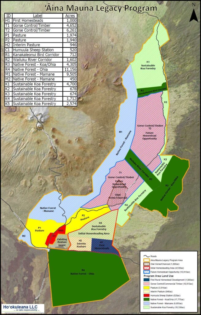
Kanakaleonui Bird Corridor (KBC), located on the east slope of Mauna Kea, is a unique transition zone from a Tropical Montane Cloud Forest to a colder, drier subalpine forest.  (Pigao)

The KBC corridor is a continuous uphill slope that currently represents a gradient of woodland to grassland. The dry subalpine landscapes show sharp climate changes with small elevational changes that are easily distinguishable by the amount and type of vegetation present.

Kanakaleonui Corridor is on Department of Hawaiian Home Lands land between Mauna Kea Forest Reserve and Hakalau Forest NWR).  It has many forest birds, especially ‘i‘iwi, ‘apapane, ‘amakihi, ‘elepaio, ‘akiapōlā‘au, and ‘io.

These species (and juveniles of these) are known to travel between wet forests and subalpine māmane forests during the bloom.  The Kanakaleonui Bird Corridor is an interconnecting corridor for this travel. (Hawaii’s Comprehensive Wildlife Conservation Strategy)

© 2025 Ho‘okuleana LLC

Filed Under: Place Names, Economy, General, Hawaiian Traditions Tagged With: Hawaii, Mauna Kea, Forest Birds, Kanakaleonui

April 8, 2025 by Peter T Young Leave a Comment

Six Active Volcanoes in Hawai‘i

The Hawaiian Islands are at the southeast end of a chain of volcanoes that began to form more than 70 million years ago. Each island is made of one or more volcanoes, which first erupted on the floor of the Pacific Ocean and emerged above sea level only after countless eruptions.

Hawaiʻi sits over a ‘hot spot,’ the Hawaiian hot spot.

It’s one hot spot, but lots of volcanoes have formed over it.  The Islands are above a moving sea floor of the North Pacific Ocean (the Pacific Ocean is mostly floored by a single tectonic plate known as the “Pacific Plate.”)

The Pacific Plate is moving over the layer in the Earth known as the Asthenosphere. This movement takes it to the northwest.  As the plate moves over a fixed spot deeper in the Earth where magma (molten lava) forms, a new volcano can punch through this plate and create an island.

As the plate moves away, the volcano stops erupting and a new one is formed in its place. With time, the volcanoes keep drifting westward and getting older relative to the one active volcano that is over the hot spot.

As they age, the crust that they sit on cools and subsides. This, combined with erosion of the islands, once active volcanism stops, leads to a shrinking of the islands with age and their eventual submergence below the ocean surface.

Each island is made up of at least one primary volcano, although many islands are composites of more than one. The Big Island, for instance, is constructed of 5 major volcanoes: Kilauea, Mauna Loa, Mauna Kea, Hualālai and Kohala (the island is still growing, but is basically about 400,000-years old.)

About 40-million years ago, the Pacific Plate changed direction from north to northwest – so the Emperor Seamounts run more north-south, the Hawaiian Ridge north-westerly.

Midway Island is 27.7-million years old; Meiji Seamount the northern part of the Emperor Seamount (near the end of the Aleutian chain) is about 80-million years old.

All of these are still youngsters, when you look at the perspective, say, of the dinosaurs.  The Islands weren’t even a glimmer in anyone’s eyes when dinosaurs walked the Earth; sixty-five million years ago the last of the non-avian dinosaurs went extinct, after living on Earth for about 165-million years.  (USGS)

If all of Earth time from the very beginning of the dinosaurs to today were compressed into 365 days (1 calendar year), the dinosaurs appeared January 1 and became extinct the third week of September.

Using this same time scale, the Earth would have formed approximately 18.5-years earlier. By comparison, people have been on earth only since December 31 (New Year’s eve.)  (USGS)

While we typically think of and/or hear news reports of eruptions on Kilauea and Maunaloa, presently, the US Geological Survey (USGS) Hawaiian Volcano Observatory  (HVO) monitors the six currently active volcanoes in Hawai‘i.

The Island of Hawai‘i, with four active volcanoes, is liveliest. Between 1912 and 2012, there were nearly 50 Kīlauea eruptions, 12 Mauna Loa eruptions, and one Hualālai intrusion of magma.

Kīlauea, the youngest and most active volcano on the Island of Hawai‘i, erupted almost continuously from 1983 to 2018 at Pu‘u‘ō‘ō and other vents along the volcano’s East Rift Zone. Since then, there have been periodic eruptions in and nearby Halema‘uma‘u crater at the volcano’s summit.

In 2018, Kīlauea experienced the largest lower East Rift Zone eruption and summit collapse in at least 200 years. Several summit eruptions since December 2020 have generated lava lakes that have been slowly filling in the collapsed area, including Halema‘uma‘u crater. About 90 percent of the volcano is covered with lava flows less than 1,100 years in age.

Mauna Loa, the largest volcano on Earth, has erupted 34 times since 1843. An eruption 1984 lasted 22 days and produced lava flows which reached to within about 4.5 miles of Hilo, the largest population center on the Island of Hawai‘i.

The most recent eruption in 2022 lasted two weeks and erupted lava flows that came to within 1.7 miles of the Daniel K Inouye Highway (Saddle Road). Lava flows less than 4,000 years old cover about 90 percent of the volcano.

Hualālai, the third most active volcano on the Island of Hawai‘i, has erupted three times in the past 1,000 years and eight times in the past 1,500 years.

The most recent eruption in 1801 generated a lava flow that reached the ocean and now underlies the Kona International Airport. Lava flows less than 5,000 years old cover about 80 percent of the volcano.

Mauna Kea, the highest volcano on the Island of Hawai‘i, erupted most recently between about 6,000 and 4,500 years ago from at least seven separate summit-area vents, producing lava flows and cinder cones. Glaciers covered parts of the volcano’s summit area during the recent ice ages, the only Hawaiian volcano known to have been glaciated.

Kama‘ehuakanaloa (formerly Lō‘ihi Seamount), the only known active Hawaiian submarine volcano, erupted most recently in 1996 during an earthquake swarm of more than 4,000 events that were recorded by the HVO seismic network. The volcano’s summit is about 3,179 ft below sea level, located 22 miles southeast of the Island of Hawai‘i.

Haleakalā, the only active volcano on the Island of Maui, erupted most recently between about 600 and 400 years ago. In the past 1,000 years, at least 10 eruptions produced lava flows and tephra cones from the rift zone that crosses the volcano from southwest to east and through Haleakalā Crater. (All here is from the US Geological Survey (USGS.))

© 2025 Ho‘okuleana LLC

Filed Under: General Tagged With: Haleakala, Kilauea, Mauna Kea, Halemaumau, Loihi, Volcanoes, Hualalai, Kamaehuakanaloa, Hawaii, Mauna Loa

  • 1
  • 2
  • 3
  • …
  • 5
  • Next Page »

Images of Old Hawaiʻi

People, places, and events in Hawaiʻi’s past come alive through text and media in “Images of Old Hawaiʻi.” These posts are informal historic summaries presented for personal, non-commercial, and educational purposes.

Info@Hookuleana.com

Connect with Us

  • Email
  • Facebook
  • LinkedIn
  • Twitter
  • YouTube

Recent Posts

  • ʻĪmaikalani
  • About 250 years Ago … Give Me Liberty, Or Give Me Death
  • Herbert, William & Jack
  • Lake Waiau
  • Silva’s Stores
  • Jones Act
  • Lady in Waiting

Categories

  • Ali'i / Chiefs / Governance
  • Buildings
  • Missionaries / Churches / Religious Buildings
  • Hawaiian Traditions
  • Military
  • Place Names
  • Prominent People
  • Schools
  • Sailing, Shipping & Shipwrecks
  • Economy
  • Voyage of the Thaddeus
  • Mayflower Summaries
  • American Revolution
  • General

Tags

Albatross Al Capone Ane Keohokalole Archibald Campbell Bernice Pauahi Bishop Charles Reed Bishop Downtown Honolulu Eruption Founder's Day George Patton Great Wall of Kuakini Green Sea Turtle Hawaii Hawaii Island Hermes Hilo Holoikauaua Honolulu Isaac Davis James Robinson Kamae Kamaeokalani Kameeiamoku Kamehameha Schools Lalani Village Lava Flow Lelia Byrd Liberty Ship Liliuokalani Mao Math Mauna Loa Midway Monk Seal Northwestern Hawaiian Islands Oahu Papahanaumokuakea Marine National Monument Pearl Pualani Mossman Quartette Thomas Jaggar Volcano Waikiki Wake Wisdom

Hoʻokuleana LLC

Hoʻokuleana LLC is a Planning and Consulting firm assisting property owners with Land Use Planning efforts, including Environmental Review, Entitlement Process, Permitting, Community Outreach, etc. We are uniquely positioned to assist you in a variety of needs.

Info@Hookuleana.com

Copyright © 2012-2024 Peter T Young, Hoʻokuleana LLC

Loading Comments...