The island of Oʻahu is divided into 6 moku (districts), consisting of: ‘Ewa, Kona, Koʻolauloa, Koʻolaupoko, Waialua and Waiʻanae. These moku were further divided into 86 ahupua‘a (land divisions within the moku.)
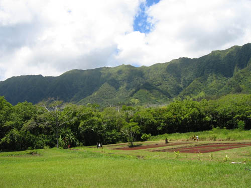
Punaluʻu (approximately 4,215-acres) is one of the 32 ahupua‘a that make up the moku of Koʻolauloa on the windward and north shore side of the island. It extends from the top of the Koʻolau mountain (at approximate the 2,700-foot elevation) down to the ocean.
After Kamehameha conquered Oʻahu (1795,) his nephew, Kekuaokalani, was reportedly raised by the priest Kahonu (kahuna of the Kaʻumakaulaula Heiau) in the upland forests of Punaluʻu. (Maly)
(Following the death of Kamehameha (1819,) King Kamehameha II (Liholiho) declared an end to the kapu system. Kekuaokalani, Liholiho’s cousin, opposed the abolition of the kapu system and assumed the responsibility of leading those who opposed its abolition. The two powerful cousins engaged at the final Hawaiian battle of Kuamoʻo. Liholiho won.)
One of the earliest written accounts noting Punaluʻu is by Levi Chamberlain, who journeyed around the island of O‘ahu in 1828 to inspect the newly forming school system: “… I commenced the examination of the schools belonging to Punaluʻu & the two adjoining districts, three in number; which occupied the whole of the forenoon.” (Chamberlain, HHS)
Chamberlain, further noted Chinese in the region: “Leaving this place we walked on to Mākao (an ahupuaʻa just up the coast from Punaluʻu) a place so named from the town of Macao in Canton (China) …” (Chamberlain, HHS)
“Vessels which arrive here from Canton (and) usually anchor … . Canton & the Chinese empire is by the natives called Makao, for this reason: Vessels which arrive here from Canton usually anchor at Macao and there take in their cargo….” (Chamberlain, HHS) (later, more Chinese came.)
The ahupuaʻa of Punaluʻu was later awarded to William Leleiōhoku in the Māhele ‘Āina of 1848, and in 1883, was inherited by Princess Bernice Pauahi Bishop.
Since traditional times, the native tenants of Punalu‘u worked closely with the native tenants of neighboring lands, as the Punalu‘u stream also crossed or bounded those lands. The earliest native land records of Punalu‘u and vicinity document that extensive lo‘i kalo (taro pond fields) and ʻauwai (irrigation ditches) were developed on the land. (Maly)
Then, much of the former loʻi were converted for rice cultivation. Many of the immigrant Chinese population, having fulfilled their labor contracts to work at the sugar plantations (starting in 1852,) came to Koʻolauloa to grow rice; initially as laborers, then taking control.
By 1862, the ali‘i owners of the land, entered into partnerships and leases with foreigners – initially, Caucasians – for the development of rice plantations. Between the 1870s to 1900, rice was the primary product of the area, followed by kalo. (Maly)
In 1882 the US Congress passed the Chinese Exclusion Act; then, Japanese workers were brought in to take their place. Within only five years the Japanese constituted more than forty-two percent of the plantation work force and one-seventh of the total population.
“Punaluʻu – 26-miles from Honolulu, is reached within a short time of leaving Kahana. Here is a very large rice plantation, extending a considerable distance up the valley, and occupying all the lower land at its mouth.”
“The population at this place is almost exclusively Chinese, large numbers being settled here with their wives. Quite a considerable village extends along the shore, and houses are to be seen far away up the valley.” (Whitney, 1890)
The resources at Punalu‘u were developed into significant business interests, including the development of mills and water distribution systems; and a pier and warehouses, which were situated in the vicinity of the present-day park facility.
There were two rice mills, one gas-powered facility in Kaluanui and the other, located in Punaluʻu Valley, was water-powered. A large part of the rice grown in the region was processed at these mills. (Chang)
In the early 1900s, “there are five lines of railway within the Territory of Hawaiʻi. The Oʻahu Railway & Land Company operating between Honolulu and Kahuku, 71.3-miles, with a branch some 11-miles in length, running from Waipahu to the pineapple plantation, of Wahiawa.”
“At Kahuku, a connection is made with the Koʻolau railway, adding some ten miles to the length of the road (into Koʻolauloa.) This railway system has opened up thousands of acres of rich sugar lands and handles a very large freight. (Hawaiian Forester and Agriculturalist, 1908)
“The extension of the railway from Kahuku to Kahana (put in by James B Castle, passing through Punaluʻu) has helped the district wonderfully. New houses are springing up, old ones have been repaired and houses long deserted are again peopled by families who forsook the country for town and who have come back to the land again.”
“There is a very good store at Hauʻula today and visitors can be put up very comfortably and at a reasonable rate by Mr Aubrey, the station agent and proprietor of the store.” (Hawaiian Star, December 4, 1909)
Some of the rice crop was shipped to Honolulu was shipped on the Koʻolau Railway to Kahuku, then on OR&L the rest of the way (around Kaʻena Point.) (Chang)
Castle was also interested in his own agricultural ventures. In 1906, he leased and acquired large and smaller parcels for the Koʻolau Agricultural Company. Under Castle’s tenure, hundreds of acres of Punalu‘u land were leased to Japanese tenants for the cultivation of taro and pineapples.
By the 1920s, it was getting too costly to grow rice and there was growing competition coming from Florida, Texas and California; so, most of the rice planters had given up agriculture and moved from Punaluʻu and other areas to Honolulu. Rice production, once the 2nd-largest industry (after sugar) passed into history.
Castle’s interests in the Koʻolau Agricultural and Koʻolau Railway Companies were later (1926) absorbed by Zion Securities of Lāʻie, and later transferred to the Kahuku Sugar Plantation (1931.) (Maly) Sugar was planted in Punaluʻu until the 1970s.
In 1994, the Punaluʻu Community Association (formed 50-years prior to protect and enhance the rural Hawaiian lifestyle in the area) submitted a petition to designate the ahupuaʻa of Punaluʻu as a surface water management area to the State Water Commission.
They and others later formed the Punaluʻu Watershed Alliance (2005; through a Memorandum of Understanding with the Water Commission, Punaluʻu Community Association, Kamehameha Schools, Honolulu Board of Water Supply and the USGS.)
The Punaluʻu Watershed Alliance is working on a stream restoration and flood mitigation plan, an agricultural plan, the expansion of irrigation systems for diversified agriculture and aquaculture (including restoration of taro loʻi.)
Part of the work includes modernizing the old plantation irrigation system that served various agricultural users in Punaluʻu. The old ditch delivery system leaked, wasted water, clogged easily and required extensive maintenance to clear obstructions.
The old ditch delivery system was replaced with a new pipe delivery system, resulting in more efficient and reliable operation, as well as lower maintenance. With this, folks are also restoring the old loʻi that once grew kalo (taro,) then rice – back to kalo.
The associated KSBE Punaluʻu Ahupuaʻa Plan has as its mission statement: “Punaluʻu is a place of abundance. (He ‘Āina Momona ‘O Punaluʻu) Our relationship to the ‘āina and our Hawaiian values sustain the traditions and productivity of the ahupua’a, stimulate learning opportunities, nurture a healthy community, and perpetuate its rural character.”