Images of Old Hawaiʻi

  • Home
  • About
  • Categories
    • Ali’i / Chiefs / Governance
    • American Protestant Mission
    • Buildings
    • Collections
    • Economy
    • Missionaries / Churches / Religious Buildings
    • General
    • Hawaiian Traditions
    • Other Summaries
    • Mayflower Summaries
    • Mayflower Full Summaries
    • Military
    • Place Names
    • Prominent People
    • Schools
    • Sailing, Shipping & Shipwrecks
    • Voyage of the Thaddeus
  • Collections
  • Contact
  • Follow

February 19, 2023 by Peter T Young Leave a Comment

1871 Trail & Alahaka Ramp

“We walked a mile over a raised macadamized road of uniform width; a road paved with flat stones and exhibiting in its every detail a considerable degree of engineering skill.”

“The stones are worn and smooth, and pushed apart in places, so that the road has the exact appearance of those ancient paved highways leading out of Rome which one sees in pictures.” (Mark Twain, Sacramento Daily Union, September 22, 1866)

Although the canoe was a principal means of travel in ancient Hawai`i, extensive cross-country trail networks enabled gathering of food and water and harvesting of materials for shelter, clothing, medicine, religious observances and other necessities for survival.

Ancient trails, those developed before western contact in 1778, facilitated trading between upland and coastal villages and communications between ahupua‘a and extended families.

These trails were usually narrow, following the topography of the land. Sometimes, over ‘a‘ā lava, they were paved with water-worn stones.

Alahele (trails) and alaloa (regional thoroughfares) were an integral part of the cultural landscape of South Kona and all Hawai‘i. The alahele provided access for local and regional travel, subsistence activities, cultural and religious purposes, and for communication between extended families and communities. Trails were important features of the cultural landscape.

Historical accounts describe at least two primary trails of regional importance in the South Kona region. One trail crossed the makai (near shore) lands, linking coastal communities and resources together. The other major trail of this region is “Kealaʻehu” (The path of Ehu), which passes through the uplands (in the vicinity of the Mamalahoa Highway.) (Rechtman)

Until the 1840s, overland travel was predominantly by foot and followed the traditional trails. By the 1840s, the use of introduced horses, mules and bullocks for transportation was increasing, and many traditional trails – the ala loa and mauka-makai trails within ahupua‘a – were modified by removing the smooth stepping stones that caused the animals to slip.

Eventually, wider, straighter trails were constructed to accommodate horse drawn carts. Unlike the earlier trails, these later trails could not conform to the natural, sometimes steep, terrain.

It was probably Kuakini, Governor of Hawaiʻi Island from 1819 to 1844, who was very aggressive in building roads with prison labor and took the initiative in modifying trails for horse travel. This often involved throwing out the steppingstones and adding curbstones. (Curbstones enabled animals to follow a path without the rider’s constant guidance.) (NPS)

They often by-passed the traditional trails as more remote coastal villages became depopulated due to introduced diseases and the changing economic and social systems.

By the early-1850s, specific criteria were developed for realigning trails and roadways, including the straightening of alignments and development of causeways and bridges.

“The history of road making in this kingdom does not date far back. The first law that we find recorded was enacted in 1840, which as well as the laws of 1846 and 1850 gave to the Governors a general control of the roads, with power to make new roads and employ prisoners in their construction.”

“But no system of road making has ever been introduced, and the whole subject has been left to be executed as chance dictated. In 1852 road supervisors were made elective by the people, at the annual election in January. This change worked no improvement in the roads, as the road supervisors, in order to remain popular, required the least possible amount of labor, and in many districts an hour or two of work in the morning was considered as a compliance with the road law.”

“Under this law the road supervisors were pretty much to themselves, and though accountable to the Minister of the Interior, they considered favor of their constituents of more importance. This law was found productive of more evil than good, and during the last session of the legislature a new road law was passed, which goes in to force on the 1st of January 1857.”

“This new law gives to the Minister of the Interior the appointment of road supervisors throughout the Kingdom, who are subject to such general instructions (we suppose in regard to the construction of roads) as he may issue.” (Pacific Commercial Advertiser, September 25, 1856)

In 1871, a coastal trail that originally extended from Napoʻopoʻo south to Hoʻokena was repaired, and renamed the 1871 Trail. It is a section of the historic coastal Alaloa (regional trail) and was a primary route of travel between communities, royal centers, religious sites and resources. (It was improved as a ‘two-horse trail’ because it was widened to accommodate two horses.)

The Alahaka Ramp, located near the southern end of the Keanaeʻe Cliffs, is a massive stone ramp that ascends the pali from Keokea into Kiʻilae and connects the 1871 trail to Kiʻilae Village.

It is during this time that a series of large-scale government programs were initiated that focused on improvements to public resources, such as roadways.

It is one of the significant road construction events of this period. Prior to the construction of the ramp, folks used a ladder or rope to get up the slope. Alahaka ramp was built to allow horses to continue on the trail.

The 1871 Trail was used as part of a trade route in Hawaii. Having horses meant that people were able to transport more goods to trade, so it was very important that horses could navigate the trail.

In regards to the Alahaka Ramp, the first reference of a ‘constructed ramp’ is found in a letter to the Minister of the Interior dated February 4, 1868. In this letter, George Hardy, the road supervisor at the time, said:

“In South Kona, I have repaired (a very) bad place known by the name of Alahaka in the village of Kiʻilae, a place of great danger where several horses had been kill’d: and where people were in danger of going up and down. I have made it wide and a substantial road.” (NPS)

As noted in a December 31, 1897 letter, the Alahaka Ramp had fallen into a state of disrepair, when road supervisor TH Wright wrote: “Napoʻopoʻo to Hoʻokena beach road in a fearful condition, it needs repair of the worst kind. The Walahaka pali is very dangerous. This road is used every day for the convenience of the public, going and back to these places.” (NPS)

Wheeled vehicles did not enter Honaunau until 1918; travel in that area continuing to be by horses, mules and donkeys, as well as by foot. Although the area remained somewhat isolated due to the lack of a cart road, better trails continued to be built for mounted traffic.

In 1918 the trail section north of Honaunau was improved for wheeled traffic; however, the section south to Hoʻokena was never modified for motorized vehicles.

In 1951, a large earthquake caused an upper section of the ramp to slough off, which over the next ten years, continued to deteriorate. Twelve years later, the newly established National Park, conducted a rebuilding the entire makai (ocean-facing) side with steel rebar, mortar and stones.

A portion of the 1871 Trail, as well as the Alahaka Ramp are situated within the Puʻuhonua O Honaunau National Historical Park and is available to hike – from Honaunau to Hoʻokena. Two trailheads: at the National Historical Park or Hoʻokena Beach Park. (Round trip is about 6.5-miles.)

© 2022 Hoʻokuleana LLC

1871_Trail-Alahaka_Ramp-NPS
1871 Trail looking north toward the Pu'uhonua, Keanae'e Cliffs to the right
1871 Trail looking north toward the Pu’uhonua, Keanae’e Cliffs to the right
Alahaka Ramp-1871_trail
Alahaka Ramp
Alahaka Ramp
Alahaka Ramp
Alahaka Ramp
1871 Trail
1871 Trail
1871 Trail
1871 Trail
Alahaka Ramp
Alahaka Ramp
Alahaka Ramp
Alahaka Ramp
1871 Trail in 1963
1871 Trail in 1963
NPS Masons stabilize the Alahaka Ramp
Masons repair the Alahaka Ramp-1963
Petrified Niagara
Petrified Niagara
Honaunau_Section_Reg1445-1888
Honaunau_Section_Reg1796-1896
Keei_2-Honaunau-Reg1457

Filed Under: Hawaiian Traditions, Place Names Tagged With: Hawaii, Kona, Puuhonua O Honaunau, Puuhonua O Honaunau National Historical Park, 1871 Trail, Alahaka Ramp

February 18, 2023 by Peter T Young Leave a Comment

Kuāuna

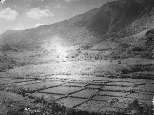
According the research and reporting by noted archaeologists, there were three main technological advances resulting in food production intensification in pre-contact Hawai‘i: (a) walled fishponds, (b) terraced pondfields with their irrigation systems and (c) systematic dry-land field cultivation organized by vegetation zones.

The lo‘i kalo (terraced pondfields), a technological invention by Hawaiian Polynesians, was the development of their extended stone-faced, terraced pondfields (lo‘i) and their accompanying irrigation systems (‘auwai) for the intensive cultivation of wetland taro (kalo.)

“The ground within the lo‘i [was] broken by means of a mattock or ‘ō‘ō. ‘Ō‘ō designates the tool largely used by the natives in cultivation in preference to the implements of modern farmers.”

“The ‘ō‘ō closely resembles in its manner of use the sharpened stick of kauila or other hard wood, used by them previous to their knowledge of iron.  The first metal ‘ō‘ō were blubber spades brought here by the whaling-vessels.”

“The boundaries of a lo‘i depend largely upon the shapes of adjacent lo‘i, and upon the relative positions of the various levels along which the irrigation water is to run.”

“The embankments of the lo‘i are built up of stones and clods of earth. These embankments were commonly known as kuāuna. … Names less frequently used, for the embankments of the lo’i, were ika, kaika and kuaio.”

“In former times the kuāuna between the lo‘i was much wider than at present. They served as a convenient place on which to throw the grass and weeds pulled up from the lo’i until they were wanted as fertilizer.”

“Often sugar-cane, banana plants, or the ki plant, grew luxuriantly on these kuāuna. As kalo land increased in value the kuāuna naturally shrunk in width, and with the advent of the Chinese planter they were often made too narrow to walk upon dry shod. Ho‘ohu meant to run along the bank of a kalo patch.”

“The side or border of an upland kalo field was called iwi. Iwi means a bone, a name applied to the long rows of stones gathered from the mo‘o ‘āina or to a narrow strip of upland to be planted with kalo or potatoes.”

“These iwi always run in the direction of the slope from the sea towards the mountains. As they coincide with the division lines between the fields, the term iwi ‘āina came to mean the boundaries between such lands, and is a term often used in that sense in the descriptions in the Hawaiian language on record in the Land Office.”

“If necessary considerable soil is taken from the lo‘i and put upon the embankments so that the surface of the lo’i will be below the level of the water supply. La‘ola‘o la‘au were the little sticks put down to sustain the kuāuna or bank of the kalo patch.”

“Water is then turned in and is soon soaked up by the broken soil. While the ground is still wet it is dug up or plowed several times. The Hawaiians call this labor mahi-ai. (The Hawaiian Forester and Agriculturist, Volume 11, 1914)

The terraces were irrigated with water brought in ditches (‘auwai) from springs and streams high in the valleys, allowing extensive areas of the valleys to be cultivated.

The irrigation ditches and pondfields were engineered to allow the cool water to circulate among the taro plants and from terrace to terrace, avoiding stagnation and overheating by the sun (which would rot the taro tubers).

An acre of irrigated pondfields produced as much as five times the amount of taro as an acre of dryland cultivation. Over a period of several years, irrigated pondfields could be as much as 10 or 15 times more productive than unirrigated taro gardens, as dryland gardens need to lie fallow for greater lengths of time than irrigated gardens.

In addition, walled pondfields not only produce taro, but were also used to raise an additional source of food, freshwater fish (primarily the Hawaiian goby (‘o‘opu nakea) and certain kinds of shrimp (‘opae)).

Captain George Vancouver visited O‘ahu in 1792 and wrote about the taro gardens in tine Waikīkī-Kapahulu-Mo‘ili‘ili-Manana complex that he observed:

“Our guides led us to the northward through the village [Waikīkī], to an exceedingly well-made causeway, about twelve feet broad, with a ditch on each side.”

“This opened to our view a spacious plain … the major part appeared divided into fields of irregular shape and figure, which were separated from each other by low stone walls, and were in a very high state of cultivation.”

In 1815, the explorer Kotzebue added to these descriptions by writing about the gardens and the artificial ponds that were scattered throughout the area:

“The luxuriant taro-fields, which might be properly called taro-lake, attracted my attention.  Each of these consisted of about one hundred and sixty square feet, forms a regular square, and walled round with stones, like our basins.”

“This field or tank contained two feet of water, in whose slimy bottom the taro was planted, as it only grows in moist places. Each had two sluices. One to receive, and the other to let out, the water into the next field, whence it was carried farther.”

© 2023 Ho‘okuleana LLC

Filed Under: Hawaiian Traditions Tagged With: Loi, Kalo, Pondfield, Kuauna

February 11, 2023 by Peter T Young Leave a Comment

1783

“… at 5 o’clock we arrived there and saw a number of People, I believe between 2 and 300 … we still continued advancing, keeping prepared against an attack tho’ without intending to attack them … they fired one or two shots, upon which our Men without any orders rushed in upon them, fired and put ’em to flight; several of them were killed”. (Diary of Lt. John Barker, Library of Congress)

The first shot (“the shot heard round the world”) was fired just as the sun was rising at Lexington. The American militia were outnumbered and fell back; and the British regulars proceeded on to Concord.

On April 19, 1775, the Battles of Lexington and Concord were the first military engagements of the American Revolutionary War. The battles marked the outbreak of open armed conflict between the Kingdom of Great Britain and its thirteen colonies of British North America.

Following this, the Continental Congress adopted the Declaration of Independence and it was signed by 56-members of the Congress (1776.) The next eight years (1775-1783) war was waging on the eastern side of the continent. The main result was an American victory and European recognition of the independence of the United States.

The formal end of the war did not occur until the Treaty of Paris and the Treaties of Versailles were signed on September 3, 1783 and recognized the sovereignty of the United States over the territory bounded roughly by what is now Canada to the north, Florida to the south, and the Mississippi River to the west.

The treaty document was signed by John Adams, Benjamin Franklin and John Jay (representing the United States) and David Hartley (a member of the British Parliament representing the British Monarch, King George III.)

The last British troops left New York City on November 25, 1783, and the US Congress of the Confederation ratified the Paris treaty on January 14, 1784.

While the Colonists were battling the British, the Hawaiian Islands were divided into four chiefdoms: (1) the island of Hawaiʻi under the rule of Kalaniʻōpuʻu, who also had possession of the Hāna district of east Maui; (2) Maui (except the Hāna district,) Molokaʻi, Lānaʻi and Kahoʻolawe, ruled by Kahekili; (3) Oʻahu, under the rule of Kahahana; and at (4) Kauaʻi and Niʻihau, Kamakahelei was ruler.

Separate chiefdoms ruled separate parts of the Islands. However, conquest was in the air and battles and negotiations for power and control were going on.

In about 1781, through a well-planned campaign, Kahekili was able to regain possession of the Hāna district and this marked the beginning of the disintegration of Kalaniʻōpuʻu’s kingdom. (Kuykendall)

Kalaniʻōpuʻu died shortly thereafter (1782.) Before his death, Kalaniʻōpuʻu gave an injunction to Kiwalaʻo and Kamehameha, and to all the chiefs, thus: “Boys, listen, both of you. The heir to the kingdom of Hawaii nei, comprising the three divisions of land, Kaʻū, Kona and Kohala, shall be the chief Kiwalaʻo. He is the heir to the lands.” (Fornander)

“As regarding you, Kamehameha, there is no land or property for you; but your land and your endowment shall be the god Kaili (Kūkaʻilimoku.) If, during life, your lord should molest you, take possession of the kingdom; but if the molestation be on your part, you will be deprived of the god.” These words of Kalaniʻōpuʻu were fulfilled in the days of their youth, and his injunction was realized. (Fornander)

On Hawaiʻi Island, civil war broke out between Kīwalaʻō’s forces and the various chiefs under the leadership of Kamehameha. In the first major skirmish, the battle of Mokuʻōhai (a fight between Kamehameha and Kiwalaʻo in July, 1782 at Keʻei, south of Kealakekua Bay on the Island of Hawaiʻi,) Kiwalaʻo was killed.

The result of the battle of Mokuʻōhai was virtually to split the island of Hawaiʻi into three independent and hostile factions. The district of Kona, Kohala and portions of Hāmākua acknowledged Kamehameha as their sovereign. (Fornander)

The remaining portion of Hāmākua, the district of Hilo and a part of Puna, remained true to and acknowledged Keawemauhili as their Mōʻī; while the lower part of Puna and the district of Kaʻū, the patrimonial estate of Kīwalaʻō, ungrudgingly and cheerfully supported Keōua against the mounting ambition of Kamehameha. (Fornander)

On Maui, “At that time, Kahekili was plotting for the downfall of Kahahana and the seizure of Oʻahu and Molokaʻi, and the queen of Kauaʻi was disposed to assist him in these enterprises.” (Kalākaua)

Kahekili deceived Kahahana by having him believe Kaʻōpulupulu (his kahuna, priest) had offered the government and throne of Oʻahu to him (Kahekili), but that out of affection for his nephew he had refused; and he intimated strongly that Kaʻōpulupulu was a traitor to Kahahana.

Kahahana believed the falsehoods and it subsequently caused friction between Kahahana and Kaʻōpulupulu and the Oʻahu King turned a deaf ear to his kahuna’s advice and by the later part of 1782 or beginning of 1783, he arranged to have Kaʻōpulupulu killed.

Weakened, Kaʻōpulupulu commanded his wounded son, who had gained a point where a few steps would have placed him at the mercy of the angry sea: “E nui ke aho e kuʻu keiki a pa ke kino I ka ili kai a na ke kai ka ua ʻāina la” …

“Spend not your strength my son until your body strikes the surface of the ocean, for the land belongs to the sea.” This cryptic message culminated in the invasion of Oʻahu by Kahekili, aliʻi nui of Maui. (Nui; Cultural Surveys)

With his main obstacle removed, Kahekili prepared for an invasion against Oʻahu and Kahahana. He called on Kahahawai, his special friend, strategist and war chief. Kahekili’s warriors landed at Waikīkī in the beginning of 1783.

While Kahekili and his Maui army were camped near the heiau at ʻApuakehau, without authorization from Kahahana, the Eight of Oʻahu suddenly attacked the Maui warriors. The conflict was hand to hand, and in that respect was favorable to the eight men well-skilled in the use of spear and javelin.

Side by side, striking and smiting all before them, the little band forced its way into the heart of the body of its foes. It has been said that this was a fight “to which Hawaiian legends record no parallel.” Eight men attacked an army and for some time were victorious in their onslaught. (Westervelt)

Kahahana’s army was later routed, and he and his wife fled to the mountains. For nearly two years or more they wandered over the mountains, secretly aided, fed and clothed by his supporters. He was finally betrayed and killed by his wife’s brother. (Kanahele)

Kahekili and his eldest son and heir-apparent, Kalanikūpule, conquered Kahahana, adding Oʻahu under his control. (Kahekili’s son, Kalanikūpule, inherited his chiefdom; Oʻahu was later lost to Kamehameha in the Battle of Nuʻuanu (1795.))

The image shows a Herb Kane depiction of the sea portion of the land-sea battle of Mokuʻōhai.

© 2023 Hoʻokuleana LLC

Sea_battle_at_mokuohai-(HerbKane)

Filed Under: Hawaiian Traditions, Place Names, Ali'i / Chiefs / Governance Tagged With: 1783, Treaty of Paris, Hawaii, Kiwalao, Mokuohai, Kalaniopuu, Kamakahelei, Kahahana, Kamehameha, Eight Of Oahu, Kalanikupule

February 6, 2023 by Peter T Young Leave a Comment

Gay Queen Of The Waves

A 2020 Proclamation issued by Governor Ray Cooper of North Carolina states, “Whereas, North Carolina was a pioneer of East Coast surfing;”

“the April 2, 1910 edition of Colliers Weekly includes a letter from Wrightsville Beach resident Burke Haywood Bridgers describing surfing activity in our state as early as 1909;”

“an announcement in the Wilmington Morning Star on June 30, 1910 includes mention of one of the earliest surfboard riding competitions in the mainland United States and direct communications with Alexander Hume Ford”.

However, that claim appears to be suspect, given other publications that predate the 1900s claim.  In the summer of 1888, several newspapers report a girl surfing at Ashbury Park, New Jersey – they refer to her as the “Gay Queen of the Waves.”

“A group of summer loungers on the beach at Ashbury park were watching the extraordinary antics of a dark-eyed bronzed-faced girl in the sea this morning. The object of all this interest and solicitude was beyond the line of breakers and standing on a plank that rose and fell with the swelling waves.”

“Her bathing dress was of some dark material, fitting close to the figure, the skirts reaching scarce to the knee. Her stockings wore of amber hue, adorned with what from the shore seemed to be vines and roses in colored embroidery. She wore no hat or cap.”

“Her hair, bound across the forehead and above the ears by a silver fillet, tumbled down upon her shoulders or streamed out upon the wind in black and shining profusion.  Her tunic was quite sleeveless , and one could scarcely fail to observe the perfect development and grace of her arms.”

“As a wave larger than those which had gone before slowly lifted the plank upon its swelling surface, she poised herself daintily upon the support, her round arms stretched out and her body swaying to and fro in harmony with the motion of the waters.”

“As the wave readied its fullest volume she suddenly, quick as a thought, and with a laugh that rang full into shore, drew herself together, sprang into the air, and, her hands clasped together and clearing her way, plunged into the rolling sea.”

“There was a little cry from timid feminine watchers on the sand, but the smiling face was above water again while they cried, and the daring Triton was upon the plank again in another moment and waiting for a second high roller.”

“So she has been amusing herself and interesting the mob for three mornings. She is as completely at ease in the sea as you or I on land, and the broad plank obeys her slightest touch.”

“When she has had enough of it she will bring the plank into shore, she riding upon the further end and guiding it like a goddess over the erects and through the foam of the biggest breakers.”

“She comes from the Sandwich Islands and is making a tour of the country. Her father is an enormously rich planter. She arrived in the park a week ago with the family of a wealthy New York importer. She is at a fashionable hotel and is one of the most charming dancers at the hotel hops, as well as the most daring swimmer on the Jersey coast.”

“She is well educated and accomplished, and, of course, speaks English perfectly, and with a swell British accent that is the despair of all the dudes.”

“She learned to be mistress of the waves in her childhood at her native home by the sea, where, she modestly says, all the girls learn swimming as a matter of course, quite as much as girls in this country learn tennis and croquet.” (Morning News from Philadelphia Press, August 17, 1888)

Although she is not identified, historian Vincent Dicks has apparently suggested that the young first-ever East Coast surfer was Emma Claudine Spreckels, the only daughter of Hawai‘i sugar baron Claus Spreckels.

Claus Spreckels (1828-1908), a German-born immigrant, made his fortune by starting a brewery and later founding the California Sugar Refinery. When he went to Hawaii in 1876 he managed to secure sole supply of sugar cane and with it much of the West Coast refined sugar market. In 1899 he founded the Spreckels Sugar Company, Inc.

The businessman gave over $25 million to his five grown children but his favorite child was the only daughter, Emma Claudine Spreckels.

He gifted an entire city block in Honolulu to her and an endowment worth almost $2 million. However, in 1893, when Emma eloped with Thomas Watson, many years her senior, she failed to tell her father. (House and Heritage)

Then, Emma “returned to her father all property, bonds, etc., which he had placed in her name. These gifts amounted to nearly $2,000,000, and were, it is said, relinquished by a single stroke of the pen by Mrs. Watson after her marriage.”

“It is reported that Mr. Spreckels was opposed to his daughter’s union with Watson, and that upon his chiding her for her seeming ingratitude in marrying against his wishes, she decided to give up her fortune, and did so, it is understood, upon the advice of her husband.” (Mount Holly News, Jan 12, 1897)

Emma ultimately married three times: after Watson died in 1904 she later married John Ferris (with her father’s blessing) and then Arthur Hutton in 1922.  Emma died on May 2, 1924 at Nuffield England.

© 2023 Ho‘okuleana LLC

Filed Under: General, Hawaiian Traditions, Prominent People Tagged With: North Carolina, Surfing, Spreckels, Surf, Emma Spreckels, New Jersey

January 23, 2023 by Peter T Young 1 Comment

Kaneʻaki Heiau

The ahupuaʻa of Mākaha, between Waiʻanae Ahupuaʻa to the southeast and Keaʻau Ahupua‘a to the northwest, extends from the coastline to the Waiʻanae Range

Earliest accounts describe Mākaha as a good-sized inland settlement and a smaller coastal settlement.  These accounts correlate well with a sketch drawn by Hiram Bingham in 1826 depicting only six houses along the Mākaha coastline.

Green describes Mākaha’s coastal settlement as “…restricted to a hamlet in a small grove of coconut trees on the Keaʻau side of the valley, some other scattered houses, a few coconut trees along the beach, and a brackish water pool that served as a fish pond, at the mouth of the Mākaha Stream.” (Cultural Surveys)

This stream supported traditional wetland agriculture – kalo (taro) – in pre-contact and early historic periods

Supporting this, Māhele documents note Mākaha’s primary settlement was inland where waters from Mākaha Stream could support lo‘i and kula plantings. Although there is evidence for settlement along the shore, for the most part, this was limited to scattered, isolated residents.

One of the best preserved heiau on Oʻahu is situated inland in Mākaha Valley.

It was originally built possibly as a Lono class agricultural heiau, probably around AD 1545. Unlike many other ancient religious sites, it remained intact after the Hawaiian religion was overthrown. (Apo)

Mākaha Stream, a focal point of the ahupuaʻa, gave life to the valley in both ancient and modern times. After six reconstruction phases, Kaneʻaki Heiau was transformed into the present day Luakini class structure. This final phase, imply direct reference to a paramount chief having commissioned and participated in the event, since only he/she could build such a heiau.  (WaiʻanaeHawaiianStudies)

Excavation data suggests that Kaneʻaki Heiau was in major operation for centuries, beginning in AD 1545. The last phase of construction occurred during Kamehameha’s campaign to unite the islands (1795-1810.)  (WaiʻanaeHawaiianStudies)

When the kapu system was overthrown, Kaneʻaki Heiau, unlike many other ancient religious sites, remained intact. In time, two restoration projects (one from 1969-70 and the other from 1996-97) were completed in order to retain the physical, spiritual and historical aspects of Kaneʻaki Heiau. (WaiʻanaeHawaiianStudies)

Nearby is a huge stone, “Pohaku O Kāne” (Stone of Kāne). This is one of the forms of the god Kāne, the uppermost of the four major gods, was worshipped by the many ʻohana that lived that ahupua’a. In modern times, it has come to be regarded as the guardian over the heiau and is still venerated by some people.  (WaiʻanaeHawaiianStudies)

Earlier restoration was completed in 1970.  A terrace and platform temple was first constructed on this site about 1545. It underwent six alterations, becoming ever larger and more sophisticated. (NPS)

Tradition says that in 1795 Kamehameha ordered that Kaneʻaki be transformed into a war heiau to insure his final conquest of Kauaʻi (Kaʻena Point, nearby, points directly at that island).  (NPS)

Supposedly those who started restoring the temple in the 1940s used Puʻukohola Heiau (at Kohala on the Big Island) as a model for the placement of the houses and idols. (NPS)

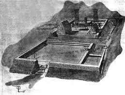
Bishop Museum staff supervised the restoration. There is a low terrace from which observers watched the ceremonies, the large hale mana for the priests on the upper platform alongside the smaller hale pahu, with an altar on pole legs between them.  (NPS)

Behind the altar is the god figure flanked by two prayer towers. These structures were reconstructed on the basis of postholes found in the stone platform.  (NPS)

Waiʻanae School Hawaii Studies Program suggests the following General Protocol Guidelines.

Kaneʻaki Heiau remains a significant place of culture to this very day. Therefore, it is very important to establish guidelines that will ensure the preservation of this sacred site, and to protect those that come to visit.  (WaiʻanaeHawaiianStudies)

  • Your approach to Kaneʻaki Heiau should be very respectful and treated as though you are in the house of god. You may be greeted and briefed by members of Hui Mālama O Kaneʻaki. Then you may proceed to the heiau trail. 
  • Unnecessary noise should be avoided or limited to the lower areas (parking/lawn area).Only guides may speak. 
  • Absolutely no entry allowed onto the main platforms. 
  • You must remain on the trail established by guides. Let your eyes and ears do the touching and not your hands. 
  • The following list of hoʻokupu are considered acceptable offerings: Maiʻa (Hawaiian banana), Awa, Niu, Kumu, Wauke, ʻOhe, Kalo, Ipu or Lua Ki. These offerings should be made in their natural state and not “prepared.” But no hoʻokupu, other than the personal mana you share with us today, is better than inferior offering.  (WaiʻanaeHawaiianStudies)

© 2023 Hoʻokuleana LLC

Filed Under: Hawaiian Traditions, Place Names Tagged With: Makaha, Kaneaki Heiau, Hawaii

  • « Previous Page
  • 1
  • …
  • 38
  • 39
  • 40
  • 41
  • 42
  • …
  • 102
  • Next Page »

Images of Old Hawaiʻi

People, places, and events in Hawaiʻi’s past come alive through text and media in “Images of Old Hawaiʻi.” These posts are informal historic summaries presented for personal, non-commercial, and educational purposes.

Info@Hookuleana.com

Connect with Us

  • Email
  • Facebook
  • LinkedIn
  • Twitter
  • YouTube

Recent Posts

  • About the Time of Columbus
  • Hawaiian Challenge
  • Liquids Coordinator
  • Lāhainā Canal
  • Boondocks
  • About 250 Years Ago … Battle of Kings Mountain
  • Cow Laws

Categories

  • Buildings
  • Missionaries / Churches / Religious Buildings
  • Hawaiian Traditions
  • Military
  • Place Names
  • Prominent People
  • Schools
  • Sailing, Shipping & Shipwrecks
  • Economy
  • Voyage of the Thaddeus
  • Mayflower Summaries
  • American Revolution
  • General
  • Ali'i / Chiefs / Governance

Tags

Albatross Al Capone Ane Keohokalole Archibald Campbell Bernice Pauahi Bishop Charles Reed Bishop Downtown Honolulu Eruption Founder's Day George Patton Great Wall of Kuakini Green Sea Turtle Hawaii Hawaii Island Hermes Hilo Holoikauaua Honolulu Isaac Davis James Robinson Kamae Kamaeokalani Kameeiamoku Kamehameha Schools Lalani Village Lava Flow Lelia Byrd Liberty Ship Liliuokalani Mao Math Mauna Loa Midway Monk Seal Northwestern Hawaiian Islands Oahu Papahanaumokuakea Marine National Monument Pearl Pualani Mossman Quartette Thomas Jaggar Volcano Waikiki Wake Wisdom

Hoʻokuleana LLC

Hoʻokuleana LLC is a Planning and Consulting firm assisting property owners with Land Use Planning efforts, including Environmental Review, Entitlement Process, Permitting, Community Outreach, etc. We are uniquely positioned to assist you in a variety of needs.

Info@Hookuleana.com

Copyright © 2012-2024 Peter T Young, Hoʻokuleana LLC

Loading Comments...