The name Māʻalaea may be a contraction of Maka-‘alaea, which means “ocherous earth beginning,” a reference to ‘alaea, a red clay commonly used for coloring sea salt. Other place names found on old maps include Kalae‘ia, Palalau and Kanaio. (Engledow)
Māʻalaea is part of the land division called Waikapū, which originates in one of four valleys created by streams known as Nā Wai Eha – The Four Waters. Those famous streams carved the steep ridges and gullies of four valleys of the West Maui mountains – Waikapū, ‘Īao, Waiehu and Waiheʻe.
The Waikapū district covers approximately half of the isthmus known as Kama‘oma‘o, reaching the south shore and including the shoreline from near Māʻalaea to Kïhei Püko‘a. (Engledow)
After Kamehameha conquered Maui in 1795, the district of Waikapū was given to Ke‘eaumoku, one of the “four Kona Uncles” who had been his main supporters.
When Ke‘eaumoku died in 1804 it went to his son, Kahekili Ke‘eaumoku, and on his death in 1824 to Kuakini, then to Leleiōhoku in 1844. During the Great Māhele of 1848, some Land Commission Awards (LCA) were granted in Kamaʻalaea.
“On the south side of western Maui the flat coastal plain all the way from Kihei and Māʻalaea to Honokahua, in old Hawaiian times, must have supported many fishing settlements and isolated fishermen’s houses, where sweet potatoes were grown in the sandy soil or red lepo near the shore.”
“For fishing, this coast is the most favorable on Maui, and although a considerable amount of taro was grown, I think it reasonable to suppose that the large fishing population which presumably inhabited this leeward coast ate more sweet potatoes than taro with their fish.” (Handy)
One product of the area was salt. In an entry dated February 1, 1817, an early voyager describes arriving at “Mackerey (Māʻalaea) Bay; here we lay until the 6th, and took on board a great quantity of hogs, salt, and vegetables.”
“This bay is very deep and wide and nearly divides the island, there being but a narrow neck of land and very low, keeping the two parts of the island together.”
“There is good anchorage; and the only danger arises from the trade winds, which blows so strong at times as to drive ships out of the bay with two anchors down; it lies NE and SW and is well sheltered from every other wind.”
“The neck of land is so low, and the land so high on each side, that the NE trade comes through like a hurricane. On this neck of land are their principal salt-pans, where they make a most excellent salt.” (Engledow)
During the California Gold Rush, between 1848 and 1850, Māʻalaea Bay functioned as a major port for transporting Hawaiian-grown goods, such as Irish potatoes, sweet potatoes, onions, pumpkins, oranges, coffee and molasses. Such goods were then shipped to San Francisco and elsewhere along the west coast of the continent. (Engledow)
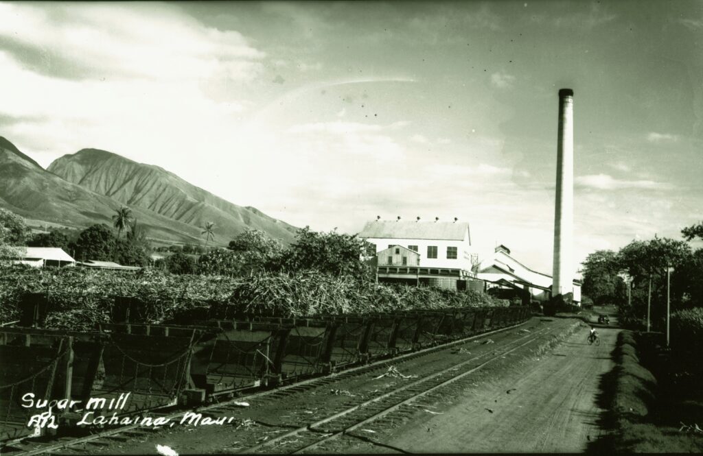
Much of the region of Waikapū was converted for agriculture during the mid-1800s, with sugar cane as the primary crop. Eventually the entire ahupuaʻa was sold to Henry Cornwell in 1885. Cornwell, along with his brother-in-law James Louzada, of Waimea, Hawaiʻi, began the Waikapū Plantation. The plantation fell under the control of the Wailuku Sugar Company in 1894. (Engledow)
Two traditional sayings, or ‘ōlelo no‘eau, referred to this area, and both have to do with its famous winds. “Ka makani kokololio o Waikapū, The gusty wind of Waikapū,” is referred to in the song “Inikinikimālie” by James Kahale.
Another is “Pā kamakani o ka Moaʻe, hele ka lepo o Kaho‘olawe i Māʻalaea, When the Moa‘e wind blows, the dust of Kaho‘olawe goes toward Māʻalaea.” (Pukui)
The area of Kapoli Spring, at the western end of Māʻalaea, is traditionally said to be the site where the high chiefs landed by canoe and been a landing point for centuries. Two large boulders are nearby; one is known as Pōhaku O Maʻalaea, situated along Kapoli Spring.
One stone is recorded as a pōhaku piko, while the other stone, known as the “Kings Table,” was used for either food preparation or adze grinding. Both stones have been moved from their original locations.
Stories tell of Kihapiʻilani landing here on his return to Maui, after he had fled Lānaʻi following a fight with his brother Lonoapiʻilani. Kihapiʻilani and his wife supposedly met people with bundles “going down makai to the shore to trade some food” at “Kamāaʻalaea,” another name for Māʻalaea.
In 1736, Kapoli in Māʻalaea was the landing place to take the remains of Kekaulike, the ruling chief of Maui, by land to Wailuku in the ʻĪao Valley. “Then, fearing the arrival of Alapaʻi bent on war, the chiefs cut the flesh from the bones of Kekaulike in order to lighten the load in carrying the body to ʻĪao [for burial].” (Kamakau)
In the early-1790s, Captain George Vancouver visited Maui and brought the first cattle and root vegetables to the island. A memorial, with Canadian totem poles, to Vancouver was erected by Canadian J Gordon Gibson near the initial landing site, across the bay at Kihei.
The main mauka/makai trail followed Kealaloloa Ridge. Because of the steep terrain in the area, there was no coastal trail between Olowalu and Māʻalaea, so “from ‘Olowalu travelers were ferried by canoe to Māʻalaea, thence to Makena”. (Rechtman)
One of the places they passed along that route was a promontory that has a modern name of McGregor Point. Here, the wind was so strong at times, that it would shred the sails of vessels trying to traverse the coastline by sea (as noted in Nūpepa Kūʻokoʻa, 1868:)
Ke holo nei ka moku a kūpono i Ukumehame, nānā aku i ka makani wili ko‘okai i ka moana, kahea mai ‘ia ke Kāpena i nā sela a pū‘ā i nā pe‘a, e hao mai ana ka makani pau nā pe‘a i ka nahaehae.
(The ship sailed on until reaching just outside of Ukumehame, watching the strong whirling winds whipping the seas, the captain called out to the sailors to furl the sails, the wind was gusting and the sails were torn.) (Rechtman)
McGregor ordered the anchor dropped for the night. With the light of the morning, McGregor awoke to find that he had discovered an excellent cove with a protecting point. The point, just over a mile southwest of Māʻalaea Bay, continues to bear his name.
In 1877, Wilder Steamship Company initiated passenger and freight service between the Hawaiian Islands. At that time, there were few navigational aids, so the steamship company was forced to erect lighted beacons for the safety of its own vessels.
One of these private aids was placed at Māʻalaea Bay in the 1880s and was an ordinary lantern, fitted with red glass and displayed from a post. In 1903, land was acquired on McGregor Point and a light was placed on the point to replace the one at Māʻalaea. This was later upgraded in 1915.
The area is known for another famous landing. On February 18, 1881, The “Beta” under the command of Captain Christian L’Orange, an early plantation owner who, under a commissioned from King Kalākaua, landed 600-Scandinavian immigrants who had signed on to work in the booming sugar plantations.
Sometime before 1825, a hand-built trail for horseback and foot travel connected Wailuku and Lāhainā (the alignment is referred to as the Lāhainā Pali Trail;) it served as the most direct route across the steep southern slopes of West Maui Mountain.
Laura Fish Judd, in 1841, described it as, “A new road had been made around the foot of the mountain, the crookedest, rockiest, ever traveled by mortals. Our party consisted of five adults and five children. We had but two horses. One of these was in a decline on starting; it gave out in a few miles.”
Around 1900, the Lāhainā Pali Trail fell out of use when prison laborers built a one-way dirt road along the base of the pali. In 1911, a three-ton truck was the first vehicle to negotiate this road, having a difficult time making some of the sharp, narrow turns.
Over the years, the road was widened and straightened until 1951, when the modern Honoapiʻilani Highway cut out many of the 115-hairpin curves in the old pali road and a tunnel cleared the way through a portion of the route.
This was the first tunnel ever constructed on a public highway in Hawaiʻi – built on the Olowalu-Pali section of the Lāhainā-Wailuku Road (now Honoapiʻilani Highway,) completed on October 10, 1951. The tunnel is 286-feet long, 32-feet wide, and more than 22 feet high. (Schmidt)
Today, a remnant of the old trail is a recreational hike – five-miles long (from Māʻalaea to Ukumehame (the ahupuaʻa adjoining Waikapū)) and climbs to over 1,600-feet above sea level.
Māʻalaea was the site of Maui’s first commercial airport. “In late 1929, Interisland Airways (which later became Hawaiian Airlines,) Hawaiian Commercial & Sugar, and the Kahului Railroad cooperated in building a paved airstrip near Māʻalaea,” but the airport closed in 1938-39. It was troubled by high winds, was too close to the West Maui Mountains and was inadequate for the larger airplanes that had come into use. (Engledow)
In May 1944, training for the assault on Saipan were held at Māʻalaea Bay and Kaho‘olawe. The Fourth and Fifth Marine Divisions also used the area for joint ship-to-shore training and amphibious landing practice before the 1945 battle of Iwo Jima. The Māʻalaea Bay area furnished an antitank moving-target range, a close-combat range, and a 20-point rifle range. The beach at Māʻalaea Bay was fortified with pillboxes and emplacements modeled after the Tarawa Beach.
Today, Māʻalaea remains as a boat landing area. The present Small Boat Harbor facilities were first developed by the Territory in 1952 and improved in 1955 and 1959. The harbor, under the control of DLNR-DOBOR, has approximately 30-berths, 61-moorings, boat ramp, a harbor office, a dry dock, a restaurant and a boat club.
Within the Harbor is the Māʻalaea Ebisu Kotohira Jinsha (completed in 1999, it is a replica of the original shrine built in 1914.) Ebisu is one of the seven lucky deities and the guardian god of fisherman and merchants; kotohira means ‘fishermen’; and jinsha means ‘shrine.’ This traditional Shinto fishing shrine on the shore of Māʻalaea Small Boat Harbor was originally located on the site of the Maui Ocean Center.
McGregor Point Lookout is a popular vantage point for seeing humpback whales from land. From this vantage point you have a sweeping view of the ocean. Humpback whales arrive in Hawaiʻi over a six-month period, with the best viewing months from mid-December through mid-April.