Images of Old Hawaiʻi

  • Home
  • About
  • Categories
    • Ali’i / Chiefs / Governance
    • American Protestant Mission
    • Buildings
    • Collections
    • Economy
    • Missionaries / Churches / Religious Buildings
    • General
    • Hawaiian Traditions
    • Other Summaries
    • Mayflower Summaries
    • Mayflower Full Summaries
    • Military
    • Place Names
    • Prominent People
    • Schools
    • Sailing, Shipping & Shipwrecks
    • Voyage of the Thaddeus
  • Collections
  • Contact
  • Follow

August 5, 2022 by Peter T Young Leave a Comment

Placial vs Spatial

In modern land description, the context is ‘spatial’ – we tend to reference things by their location, area and use – 123 Main Street, 10,000-square feet, residential.

Look at any map, GPS orientation or recall how you describe a place, etc, it’s all about space and location; you learn where you are and the physical context of it.

In old Hawaiʻi, it was the nature of ‘place’ that shaped the practical, cultural and spiritual view of the Hawaiian people.

In Hawaiian culture, natural and cultural resources are one and the same.  Traditions describe the formation (literally the birth) of the Hawaiian Islands and the presence of life on, and around them, in the context of genealogical accounts.

All forms of the natural environment, from the skies and mountain peaks, to the watered valleys and lava plains, and to the shore line and ocean depths are believed to be embodiments of Hawaiian gods and deities.  (Maly)

“The ancients gave names to the natural features of the land according to their ideas of fitness. … There were many names used by the ancients to designate appropriately the varieties of rain peculiar to each part of the island coast; the people of each region naming the varieties of rain as they deemed fitting. … The ancients also had names for the different winds.”  (Malo)

Hawaiians named taro patches, rocks, trees, canoe landings, resting places in the forests and the tiniest spots where miraculous events are believed to have taken place.  (hawaii-edu)  There were names for everything, and multiple names for many.

Place names are often descriptive of: (1) the terrain, (2) an event in history, (3) the kind of resources a particular place was noted for or (4) the kind of land use which occurred in the area so named. Sometimes an earlier resident of a given land area was also commemorated by place names.  (Maly)

“Cultural Attachment” embodies the tangible and intangible values of a culture – how a people identify with, and personify the environment around them.

It is the intimate relationship (developed over generations of experiences) that people of a particular culture feel for the sites, features, phenomena and natural resources etc, that surround them – their sense of place. This attachment is deeply rooted in the beliefs, practices, cultural evolution and identity of a people.  (Kent)

In ancient Hawai‘i, most of the common people were farmers, a few were fishermen.  Access to resources was tied to residency and earned as a result of taking responsibility to steward the environment and supply the needs of aliʻi.  Tenants cultivated smaller crops for family consumption, to supply the needs of chiefs and provide tributes.

In this subsistence society, the family farming scale was far different from commercial-purpose agriculture.  In ancient time, when families farmed for themselves, they adapted; products were produced based on need.  The families were disbursed around the Islands.  An orderly delineation became needed.

Māʻilikūkahi is noted for clearly marking and reorganizing land division palena (boundaries) on O‘ahu.  Defined palena brought greater productivity to the lands; lessened conflict and was a means of settling disputes of future aliʻi who would be in control of the bounded lands; protected the commoners from the chiefs; and brought (for the most part) peace and prosperity.  (Beamer, Duarte)

Fornander writes, “He caused the island to be thoroughly surveyed, and boundaries between differing divisions and lands be definitely and permanently marked out, thus obviating future disputes between neighboring chiefs and landholders.”

Kamakau tells a similar story, “When the kingdom passed to Māʻilikūkahi, the land divisions were in a state of confusion; the ahupuaʻa, the ku, the ʻili ʻāina, the moʻo ʻāina, the pauku ʻāina, and the kihāpai were not clearly defined.”

“Therefore, Māʻilikūkahi ordered the chiefs, aliʻi, the lesser chiefs, kaukau aliʻi, the warrior chiefs, puʻali aliʻi, and the overseers (luna) to divide all of Oʻahu into moku, ahupuaʻa, ʻili kupono, ʻili ʻaina, and moʻo ʻāina.”

What is commonly referred to as the “ahupuaʻa system” is a result of the firm establishment of palena (boundaries.)  This system of land divisions and boundaries enabled a konohiki (land/resource manager) to know the limits and productivity of the resources that he managed.

Ahupuaʻa served as a means of managing people and taking care of the people who support them, as well as an easy form of collection of tributes by the chiefs.  Ultimately, this helped in preserving resources.

A typical ahupuaʻa (what we generally refer to as watersheds, today) was a long strip of land, narrow at its mountain summit top and becoming wider as it ran down a valley into the sea to the outer edge of the reef.  If there was no reef then the sea boundary would be about one and a half miles from the shore.

When the Hawaiians lived on the land as farmers and gatherers they became intimately acquainted with and named countless features and places.

Hawaiian customs and practices demonstrate the belief that all portions of the land and environment are related; the place names given to them tell us that areas are of cultural importance.  (Maly)

This Placial versus Spatial context reflects the relationship of the people to the land.

“Sense of place is about the feeling that emanates from a place as a combination of the physical environment and the social construct of people activity (or absence of) that produces the feeling of a place.  …  People seek out Hawaiʻi because of the expectation of what its sense of place will be when they get there.”  (Apo)

“Sense of place helps to define the relationships we have as hosts and guests, as well as how we treat one another and our surroundings.”  (Taum)

“In the Hawaiian mind, a sense-of-place was inseparably linked with self-identity and self-esteem.  To have roots in a place meant to have roots in the soil of permanence and continuity.”

“Almost every significant activity of his life was fixed to a place.”

“No genealogical chant was possible without the mention of personal geography; no myth could be conceived without reference to a place of some kind; no family could have any standing in the community unless it had a place; no place of significance, even the smallest, went without a name; and no history could have been made or preserved without reference, directly or indirectly, to a place.”

“So, place had enormous meaning for Hawaiians of old.”   (Kanahele)
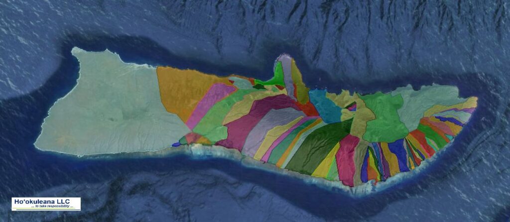
© 2022 Hoʻokuleana LLC

Filed Under: Place Names Tagged With: Mailikukahi, Ahupuaa, Palena, Cultural Attachment, Hawaii

March 4, 2022 by Peter T Young Leave a Comment

Kīpapa Gulch

Place names help tell the stories of the place.

During the reign of Māʻilikūkahi, who ruled at about the same time Christopher Columbus crossed the Atlantic, invaders from Hawai‘i and Maui arrived on O‘ahu.

In the battles, the O‘ahu forces met the opposing forces in the uplands of Waipi‘o, and a great battle occurred.

Māʻilikūkahi was raised partly in Waialua and is said to have maintained a kulanakauhale (village) there.

Fornander writes, “He (Māʻilikūkahi) caused the island to be thoroughly surveyed, and boundaries between differing divisions and lands be definitely and permanently marked out, thus obviating future disputes between neighboring chiefs and landholders.”

Kamakau tells a similar story, “When the kingdom passed to Māʻilikūkahi, the land divisions were in a state of confusion; the ahupuaʻa, the ku, the ʻili ʻāina, the moʻo ʻāina, the pauku ʻāina, and the kihāpai were not clearly defined.”

“Therefore, Māʻilikūkahi ordered the chiefs, aliʻi, the lesser chiefs, kaukau aliʻi, the warrior chiefs, puʻali aliʻi, and the overseers (luna) to divide all of Oʻahu into moku, ahupuaʻa, ʻili kupono, ʻili ʻāina, and moʻo ʻāina.”

What is commonly referred to as the “ahupuaʻa system” is a result of the firm establishment of palena (boundaries.) This system of land divisions and boundaries enabled a konohiki (land/resource manager) to know the limits and productivity of the resources that they managed – and increase its productivity.

Māʻilikūkahi is also known for a benevolent reign that was followed by generations of peace. He prohibited the chiefs from plundering the makaʻāinana, with punishment of death. His reign “ushered in an era of benign rule lasting for several generations.”

Thrum notes that while Māʻilikūkahi was peacefully disposed, he proved to be a brave defender of his realm in thoroughly defeating the invading forces.

Fornander suggests it was not considered a war between the two islands, but, rather, it was a raid by some restless and turbulent chiefs. The invading force first landed at Waikīkī and proceeded to ʻEwa and marched inland.

At Waikakalaua (an upland ʻili of Waikele) they met Māʻilikūkahi and his forces, and a bloody battle ensued. The fight continued from there to the Kīpapa gulch – stretching across Kīpapa (an ʻili of Waipiʻo,) Waikakalaua and the place known as Punaluʻu.

Tradition has it that the body count from the invaders was so great that it is said the area was paved (kīpapa “placed prone”) with their bodies.

Punaluʻu, an upland ʻili, was named for one of the invading warrior-chiefs killed during the battle. Another warrior-chief, Hilo, was also killed in the battle.

Poʻohilo (an ʻili of Honouliuli) is named from events following a battle in the Kīpapa-Waikakalaua region in which the head of Hilo was placed on a stake at this site and displayed.

Kanupo‘o (an ʻili of Waikele) may be translated as meaning, “planted skull” and seems to imply an event of some importance – it may be tied to events of the battle at Kīpapa and the naming of Po‘ohilo at Honouliuli.

Today, people suggest the gulch is ruled by the spirits of fallen warriors; there are reports that this is one of the paths of the Huakaiʻpo (night marchers) and other reports suggest a woman dressed in white hitchhiking.

The area was also a temporary home to the Naval Air Station Kipapa Field / Kipapa Army Airfield. It was used because it could accommodate two 5,000′ runways free from obstructions (however, concerns were raised about increased air congestion due to its proximity between Pearl Harbor and Wheeler Field.)

The airfield site is located south the Mililani Golf Course between Meheula Parkway and Hokuala Streets – the runways extended out to the edge of the gulch. Mililani District Park is located near the intersection of the 2 main runways.

The use of this site by the Navy would permit the concentration of carrier-group training for Naval aviation on the south side of the island of Oahu including Barber’s Point, Kīpapa Gulch, and Ford Island.

But it was not until sometime after the United States entered World War II that Kipapa Airfield was developed; the exact start date is not clear, but 1943 maps note the facility.

During the war it apparently saw little use by the Navy due to the fact that carrier aircraft were constantly deployed during the war. The Army Air Corps became the principal user of the airfield by default.

Aircraft from this airfield searched & patrolled over the surrounding Pacific area, maintaining a 24-hour vigil to avert any attack with a large number and variety of squadrons are documented to have been stationed at Kipapa Airfield during World War II.

Kipapa Field was evidently closed at some point between 1959 and 1961 (it was no longer depicted on the 1961 and later mapping.)

© 2022 Hoʻokuleana LLC

Filed Under: Place Names Tagged With: Kipapa, Night Marchers, Mililani, Huakaipo, Hawaii, Oahu, Mailikukahi, Ahupuaa, Ewa, Waikele

October 12, 2021 by Peter T Young 1 Comment

15th Century

Folks describe different ‘phases’ or ‘periods’ of human settlement and agricultural development in the Islands over time. Different people use different terms for each of these (some use varying timeframes, as well,) but they seem to generally fall into Settlement, Development, Expansion and ultimately Post-Contact.

Settlement – AD 1000-1400

It is believed that initial Polynesian discovery and settlement of the Hawaiian Islands occurred between approximately AD 1000 and 1200. (Kirch) This effectively started the ‘Settlement’ phase.

For generations, the small, slowly growing population clustered around shore sites near streams that supplied them with water. Such sites are best for inshore fishing.

The food plants of Hawaiʻi can be divided into three groups: those known as staple foods (the principal starchy foods – kalo (taro,) ʻuala (sweet potato,) ʻulu (breadfruit,) etc;) those of less importance (to add nutrients and variety to the diet;) and those known as famine foods. (Krauss)

Kamakau states that there were no chiefs in the earliest period of settlement but that they came “several hundred years afterward … when men became numerous.”

Development- AD 1400-1650

Archaeological evidence indicates a chronology of household expansion (and, by inference, to population growth, as well as increased managerial presence and a desire to produce higher yields) starting about this time. The Islands evolved from shifting cultivation into a stable form of agriculture. Likewise, a formalization of governance was taking shape.

Dr Marion Kelly noted there were three main technological advances resulting in food production intensification that started to evolve: (a) loko i‘a, walled fishponds, (b) lo‘i, terraced pondfields with their irrigation systems and (c) systematic dry-land field cultivation organized by vegetation zones.

In addition, this movement toward a centralization of government allowed for development and maintenance of large projects, such as irrigation systems, large taro loʻi, large fish ponds, heiau and trails.

Expansion – AD 1650-Contact (1778)

A population peak (usually estimated at several hundred thousand) was reached around 1650 AD, more than 100 years before contact with Europeans.

It was at this population peak, or shortly before, that Hawaiians began to inhabit less favorable coastline areas and barren zones between the coast and upland agricultural sites and to develop extensive dryland agricultural systems in marginal regions. (Cuddihy)

Large-scale irrigation works and permanent field systems were developed during the expansion period. Settlements were intruding into increasingly marginal environments, including the interiors of leeward valleys and the higher elevation slopes. Population densities in the fertile windward valleys increased, although densities in tablelands and elsewhere were much lower.

Post Contact – After 1778

At the time of Captain Cook’s arrival (1778-1779), the Hawaiian Islands were divided into four chiefdoms: (1) the island of Hawaiʻi under the rule of Kalaniʻōpuʻu, who also had possession of the Hāna district of east Maui; (2) Maui (except the Hāna district,) Molokai, Lānaʻi and Kahoʻolawe, ruled by Kahekili; (3) Oʻahu, under the rule of Kahahana; and (4) Kauai and Niʻihau, Kamakahelei was ruler.

It was not necessarily a peaceful time. Island rulers, Aliʻi or Mōʻī, typically ascended to power through familial succession and warfare. In those wars, Hawaiians were killing Hawaiians; sometimes the rivalries pitted members of the same family against each other.

In addition to deaths in wars, epidemics of infections added to the decline in Hawaiʻi’s population from approximately 300,000 at the time of Captain Cook’s arrival in 1778 to 135,000 in 1820 and 53,900 in 1876.

The Islands at the Time of Columbus (During the Development Phase – AD 1400-1650)

At about the time Christopher Columbus was crossing the Atlantic to America (1492 – he was looking for an alternate trade route to the East Indies,) exciting stuff was happening in the Hawaiian Islands.

The political governance and land management system by Aliʻi-ai-moku, was expanding and developing after two centuries since its inception, and there was a wake of progress taking place on our shores.

In this general timeframe, and not necessarily contemporaries, the Aliʻi-ai-moku (Island rulers) across the chain were: Mā‘ilikūkahi on Oʻahu, Piʻilani on Maui, ʻUmi-a-Līloa on Hawaiʻi and Kukona on Kauaʻi.

Māʻilikūkahi – Oʻahu

Soon after becoming aliʻi, Māʻilikūkahi moved to Waikīkī. He was probably one of the first chiefs to live there. Up until this time Oʻahu chiefs had typically lived at Waialua and ‘Ewa. From that point on, with few exceptions, Waikīkī remained the Royal Center of Oʻahu aliʻi, until Kamehameha I moved the seat to Honolulu.

Māʻilikūkahi is noted for clearly marking and reorganizing land division palena (boundaries) on O‘ahu. Defined palena brought greater productivity to the lands; lessened conflict and was a means of settling disputes of future aliʻi who would be in control of the bounded lands; protected the commoners from the chiefs; and brought (for the most part) peace and prosperity.

What is commonly referred to as the ‘ahupuaʻa system’ is a result of the firm establishment of palena (boundaries.) Ahupuaʻa served as a means of managing people and taking care of the people who support them, as well as an easy form of collection of tributes by the chiefs.

Piʻilani – Maui

According to oral tradition, Piʻilani unified the entire island of Maui, bringing together under one rule the formerly-competing eastern (Hāna) and western (Wailuku) multi-district kingdoms of the Island. Chief Piʻilani (“stairway to heaven”) unified West Maui and ruled in peace and prosperity. His territory included Nā Hono a Pi‘ilani, the six West Maui bays, a place he frequented.

Piʻilani’s prosperity was exemplified by a boom in agriculture and construction of heiau, fishponds, trails and irrigation systems. Famed for his energy and intelligence, Piʻilani constructed the West Maui phase of the noted Alaloa, or long trail (also known as the King’s Highway.)

His son, Kihapiʻilani laid the East Maui section and connected the island. This trail was the only ancient pathway to encircle any Hawaiian island (not only along the coast, but also up the Kaupō Gap and through the summit area and crater of Haleakalā.)

ʻUmi – Hawaiʻi Island

ʻUmi-a-Līloa (ʻUmi) from Waipiʻo, son of Līloa, defeated Kona chief Ehunuikaimalino and united the island of Hawai‘i. He then moved his Royal Center from Waipi‘o to Kona. At about the time of ʻUmi, a significant new form of agriculture was developed in Kona; he is credited with starting it. Today, archaeologists call the unique method of farming in this area the ‘Kona Field System.’

The Kona Field System was planted in long, narrow fields that ran across the contours, along the slopes of Mauna Loa and Hualālai. This intensive agricultural activity changed farming and agricultural production on the western side of Hawai’i Island; the Kona field system was quite large, extending from Kailua to south of Honaunau

The Kona Field System was described as “the most monumental work of the ancient Hawaiians.” The challenge of farming in Kona is to produce a flourishing agricultural economy in an area subject to frequent droughts, with no lakes or streams for irrigation.

Kukona – Kauai

Kukona became a symbol of the very highest ideals of chivalry in battle, was born in Kōloa and fought his defining battle at Poʻipū.

During the 15th century, an ambitious chief of Hawaiʻi who had already conquered three other islands, tried to seize Kauaʻi. He was accompanied into battle by the combined armies and chiefs of Maui, Molokai and Oʻahu. The war is known as the War of Ka‐welewele. The much smaller forces defending Kauaʻi, led by Kukona and his son Manokalanipo, soundly defeated the invaders after leading them inland and then surrounding them at the shore.

Kukona captured all four chiefs of Hawaiʻi, Oʻahu, Maui and Molokai. He had the opportunity to kill them all and assume leadership over the islands. However, he preferred peace and allowed them to return safely home with a promise that they never again make war on Kauaʻi. This peace lasted for four hundred years.

What about Puna?

The Islands were at peace, the population was growing and new intensified means of feeding the subsistence society were being developed. However, in Puna, there was a disturbance in the forest …

The longest recorded eruption at Kīlauea, arguably, was the ʻAilāʻau eruption and lava flow in the 15th century, which may be memorialized in the Pele-Hiʻiaka chant. It was the largest in Hawaiʻi in more than 1,000-years.

The flow was named after ʻAilāʻau, who was known and feared by all the people. ʻAi means the “one who eats or devours.” Lāʻau means “tree” or a “forest.” (He was the fire god before Pele arrived at Hawaiʻi Island.)

The eruption probably lasted about 60 years, ending around 1470. This large volume of lava covered a huge area, about 166 square miles (over 106,000-acres) – larger than the Island of Lānaʻi.

From the summit of the ʻAilāʻau shield, pāhoehoe lava flowed 25-miles northeastward, making it all the way to the coast. Lava covered all, or most, of what are now Mauna Loa Estates, Royal Hawaiian Estates, Hawaiian Orchid Island Estates, Fern Forest Vacation Estates, Eden Rock Estates, Crescent Acres, Hawaiian Acres, Orchid Land Estates, ʻAinaloa, Hawaiian Paradise Park and Hawaiian Beaches. (USGS)

Rapid ‘Ōhi‘a Death

There is a new disturbance in the forest …

Click HERE for more information on the Historic Periods, Agriculture Intensification, the 15th Century Rulers and the Forest.

© 2021 Hoʻokuleana LLC

Pre-contact Footprint-Hawaiian Islands-GoogleEarth-OHA-TNC

Filed Under: General, Ali'i / Chiefs / Governance, Hawaiian Traditions, Place Names, Economy Tagged With: Ailaau, 15th Century, Rapid Ohia Death, Hawaii, Umi-a-Liloa, Piilani, Mailikukahi, Kukona

August 31, 2019 by Peter T Young 1 Comment

Māʻilikūkahi

Traditions on the island of O‘ahu provide the names of a dynasty of ruling chiefs beginning with Māʻilikūkahi, honored as the first great king of O‘ahu.

Māʻilikūkahi holds a prominent place in O‘ahu legends for his wise, firm, judicious government.

He was born ali‘i kapu at the birthing stones of Kūkaniloko; Kūkaniloko was one of two places in Hawai‘i specifically designated for the birth of high ranking children; the other site was Holoholokū at Wailua on Kauai.

Māʻilikūkahi, who ruled in the 1400-1500s (at about the same time Christopher Columbus ‘discovered’ America,) was raised partly in Waialua and is said to have maintained a kulanakauhale (village) there.

There is said to have been a mythical heiau (temple) called Kapukapuākea built by the menehune. Māʻilikūkahi was taken to Kapukapuākea (heiau) at Pa‘la‘akai in Waialua to be consecrated and installed as aliʻi there.

Kapukapuākea was to the Oʻahu aliʻi what Westminster Abbey is to the kings of England, the site of ritual acknowledgement of their divine right to rule (Kirch)

Soon after becoming aliʻi, Māʻilikūkahi moved to Waikīkī. The stories tell us that he was probably one of the first chiefs to live there. Up until this time the chiefs had typically lived at Waialua and ‘Ewa.

From that point on, with few exceptions, Waikīkī remained the seat of Oʻahu aliʻi, until Kamehameha I moved the seat to Honolulu.

Māʻilikūkahi was a religious chief, built several heiau, held the priests in honor and stopped human sacrifices. The island of Oʻahu is said to have become very populous during his reign, and thrift and prosperity abounded.

Land was considered the property of the aliʻi which he held in trust for the gods. The title of aliʻi ensured rights and responsibilities pertaining to the land, but did not confer absolute ownership.

The aliʻi kept the parcels he wanted, his higher chiefs received large parcels from him and, in turn, distributed smaller parcels to lesser chiefs. The makaʻāinana (commoners) worked the individual plots of land (kuleana.)

Māʻilikūkahi is noted for clearly marking and reorganizing land division palena (boundaries) on O‘ahu. Defined palena brought greater productivity to the lands; lessened conflict and was a means of settling disputes of future aliʻi who would be in control of the bounded lands; protected the commoners from the chiefs; and brought (for the most part) peace and prosperity.

Fornander writes, “He caused the island to be thoroughly surveyed, and boundaries between differing divisions and lands be definitely and permanently marked out, thus obviating future disputes between neighboring chiefs and landholders.”

Kamakau tells a similar story, “When the kingdom passed to Māʻilikūkahi, the land divisions were in a state of confusion; the ahupuaʻa, the ku, the ʻili ʻaina, the moʻo ʻaina, the pauku ʻaina, and the kihapai were not clearly defined.”

“Therefore, Māʻilikūkahi ordered the chiefs, aliʻi, the lesser chiefs, kaukau aliʻi, the warrior chiefs, puʻali aliʻi, and the overseers (luna) to divide all of Oʻahu into moku, ahupuaʻa, ʻili kupono, ʻili ʻaina, and moʻo ʻaina.”

What is commonly referred to as the “ahupuaʻa system” is a result of the firm establishment of palena (boundaries.) This system of land divisions and boundaries enabled a konohiki (land/resource manager) to know the limits and productivity of the resources that they managed – and increase its productivity.

Māʻilikūkahi is also known for a benevolent reign that was followed by generations of peace. He prohibited the chiefs from plundering the maka‘āinana, with punishment of death. His reign “ushered in an era of benign rule lasting for several generations.”

Māʻilikūkahi’s peaceful reign was interrupted by an invasion by chiefs from Waipi‘o. It was not considered as a war between the two islands, but rather as a raid by some restless and turbulent chiefs from the Islands of Hawaiʻi.

The invading force landed at first at Waikīkī, but, for reasons not stated in the legend, altered their mind and proceeded up the Ewa lagoon and marched inland.

At Waikakalaua (Wahiawa or Waipahu) they met Māʻilikūkahi with his forces, and a battle ensued. The fight continued from there to the Kīpapa gulch. The invaders were thoroughly defeated, and the gulch is said to have been literally paved with the corpses of the slain, and received its name, “Kīpapa,” (placed prone.)

Māʻilikūkahi’s wife was Kanepukaa. They had two sons, Kalonanui and Kalona-iki, the latter succeeding his father as Aliʻi Aimoku of Oʻahu.

In the past, MAʻO Organic Farms created and facilitated ‘Āina Ho‘ōla o Māʻilikūkahi, the annual statewide Hands Turned to the Soil conference. The word ho‘ōla means to restore/give life.

The conference’s name therefore reflects an understanding that our ‘āina must itself be healthy in order to feed us and that ‘aina, kanaka and kaiaulu (land, people and community) work in concert to provide and maintain sustenance for all living things.

In 2018, the University of Hawai‘i – West Oahu Sustainable Community Food Systems Program, the Sustainable Agriculture Education Association, the University of Hawai‘i System Office of Sustainability and key community partners hosted the 2018 Sustainable Agriculture Education Association Conference and the Hoʻōla ʻĀina O Māʻilikūkahi Youth Food Sovereignty Congress.

Follow Peter T Young on Facebook 

Follow Peter T Young on Google+ 

Follow Peter T Young on LinkedIn  

Follow Peter T Young on Blogger

© 2019 Hoʻokuleana LLC

Filed Under: Ali'i / Chiefs / Governance, Place Names Tagged With: Mailikukahi, Ewa, Hawaii, Waikiki, Oahu, Kukaniloko

July 14, 2019 by Peter T Young Leave a Comment

Kūkaniloko Birthstones

The Kūkaniloko Birthstones site is one of the most significant cultural sites on O‘ahu. This significance was recognized in the listing of the site on the National and Hawai’i Registers of Historic Places.

Kūkaniloko means “to anchor the cry from within.”

The 5-acre site was acquired by the State of Hawaiʻi in 1992 and placed under the jurisdiction of State Parks to preserve and interpret this important historic site.

Kūkaniloko was one of two places in Hawai‘i specifically designated for the birth of high-ranking children; the other site was Holoholokū at Wailua on Kauai.

These royal birthing sites maintained the antiquity and purity of the chiefly lineages on O‘ahu and Kauai. It is said that chiefs from Hawai‘i Island and Maui often sought greater prestige by marrying those with these strong ancestral lineages.

The site is marked by 180 stones covering an area of about ½-acre. Many of these stones have surface depressions and fluted edges with a coating of red dirt. These surfaces are probably a combination of natural weathering and human craftsmanship over many generations.

Today, they appear as very smooth, round, “sit-spots” in the rocks, with no signs of tools or human workmanship; only their uniform symmetry and design would indicate human craftsmanship.

One can immediately visualize the use of these stone “sit-spots” in childbirth, for many of them have natural backrests behind the depressions, which would have given firm support to a straining mother-to-be. It is small wonder that these birthstones would have been revered and reserved for childbirth for chiefesses.

With assistance from her attendants, the chiefess would lean against the stone and follow the prescribed regulations for birthing (liloe kapu).

Beginning with the birth of Kapawa, Kūkaniloko became recognized as the royal birthsite on O’ahu. Based on genealogical records, the dates of Kapawa’s birth range from A.D. 1100 to A.D. 1400, but the date could be earlier.

A child born in the presence of the chiefs was called “he ali‘i” (a chief), “he akua” (a god), “he wela” (a blaze of heat). The births of at least 4 renown chiefs of O‘ahu are recorded at Kūkaniloko – La‘a (ca. 1420,) Mā‘ilikūkahi (ca. 1520,) Kalanimanuia (ca. 1600) and Kākuhihewa (ca. 1640).

The reign of these chiefs was marked by good deeds, peace and prosperity.

This place was so highly viewed that, even in later times, Kamehameha I, in 1797, previous to the birth of his son and successor, Liholiho (Kamehameha II,) made arrangements to have his birth take place at Kūkaniloko; but the illness of Queen Keōpūolani prevented that (Liholiho was born in Hilo.)

Major trails crossed the island and intersected near Kūkaniloko. The Waialua Trail ran from Waialua through Wahiawā to ‘Ewa. The Kolekole Trail from Wai‘anae crossed the Wai‘anae Range and joined the Waialua Trail near Kūkaniloko.

To the south of the birthstones is the Wai‘anae Mountain Range with prominent peaks such as Kaʻala and a dip known as Kolekole. According to oral tradition, these features create an image of a pregnant woman known as “wahine hāpai.”

From Kūkaniloko, the setting of the sun at peaks (pu‘u) along the Waiʻanae Range could be observed and used as a calendar. Some of the stones at Kūkaniloko may have been used as reference points to observe the sun setting behind, Mt. Ka‘ala at the equinox.

Likewise, it is believed that alignments and marking on the stones illustrate navigational directions. (Today, September 22, 2012) is the Autumnal Equinox; from Kūkaniloko, the setting sun is aligned with Mt. Kaʻala.)

Wahiawā is translated as place of rumbling. It is said that Wahiawā is where thunderstorms, the voices of the ancestral gods, welcomed an offspring of divine rank. Being the center of O‘ahu, Kūkaniloko is also symbolic of the piko (navel, as well as center) and thus, birth.

The site is managed and maintained through a partnership between DLNR-State Parks, the Hawaiian Civic Club of Wahiawā and the Friends of Kūkaniloko. Additional support for interpretive efforts at the site has been provided by the Wahiawā Hospital Association and the Wahiawā Community and Business Association.

The Kūkaniloko birthstones are located next to a dusty (or muddy) plantation road and are partially surrounded by former pineapple fields. The turn-off from Kamehameha Highway just north of the town of Wahiawā, at the Whitmore Village intersection.

Follow Peter T Young on Facebook 

Follow Peter T Young on Google+ 

Follow Peter T Young on LinkedIn  

Follow Peter T Young on Blogger

© 2019 Hoʻokuleana LLC

Kukaniloko_Birthing_stones
Oahu-Kukaniloko-Waianae_Mountains
Waianae_Mountains-(IfA)
Seasonal_Dates_indicated_by_points_on_Waianae_Range-as_seen_from_Kukaniloko

Filed Under: Ali'i / Chiefs / Governance, Hawaiian Traditions Tagged With: Kamehameha, Hawaii, Oahu, Kukaniloko, Mailikukahi, Keopuolani, Wahiawa, Liholiho

  • « Previous Page
  • 1
  • 2
  • 3
  • Next Page »

Images of Old Hawaiʻi

People, places, and events in Hawaiʻi’s past come alive through text and media in “Images of Old Hawaiʻi.” These posts are informal historic summaries presented for personal, non-commercial, and educational purposes.

Info@Hookuleana.com

Connect with Us

  • Email
  • Facebook
  • LinkedIn
  • Twitter
  • YouTube

Recent Posts

  • ʻŌpūkahaʻia Leaves Hawaiʻi
  • Moku
  • About 250 Years Ago … Story of the American Soldier
  • German Town
  • Nā Wai ʻEhā
  • Kāʻanapali Historical Trail & History and Legends Tour
  • Kakaʻako

Categories

  • General
  • Ali'i / Chiefs / Governance
  • Buildings
  • Missionaries / Churches / Religious Buildings
  • Hawaiian Traditions
  • Military
  • Place Names
  • Prominent People
  • Schools
  • Sailing, Shipping & Shipwrecks
  • Economy
  • Voyage of the Thaddeus
  • Mayflower Summaries
  • American Revolution

Tags

Albatross Al Capone Ane Keohokalole Archibald Campbell Bernice Pauahi Bishop Charles Reed Bishop Downtown Honolulu Eruption Founder's Day George Patton Great Wall of Kuakini Green Sea Turtle Hawaii Hawaii Island Hermes Hilo Holoikauaua Honolulu Isaac Davis James Robinson Kamae Kamaeokalani Kameeiamoku Kamehameha Schools Lalani Village Lava Flow Lelia Byrd Liberty Ship Liliuokalani Mao Math Mauna Loa Midway Monk Seal Northwestern Hawaiian Islands Oahu Papahanaumokuakea Marine National Monument Pearl Pualani Mossman Quartette Thomas Jaggar Volcano Waikiki Wake Wisdom

Hoʻokuleana LLC

Hoʻokuleana LLC is a Planning and Consulting firm assisting property owners with Land Use Planning efforts, including Environmental Review, Entitlement Process, Permitting, Community Outreach, etc. We are uniquely positioned to assist you in a variety of needs.

Info@Hookuleana.com

Copyright © 2012-2024 Peter T Young, Hoʻokuleana LLC

Loading Comments...