Images of Old Hawaiʻi

  • Home
  • About
  • Categories
    • Ali’i / Chiefs / Governance
    • American Protestant Mission
    • Buildings
    • Collections
    • Economy
    • Missionaries / Churches / Religious Buildings
    • General
    • Hawaiian Traditions
    • Other Summaries
    • Mayflower Summaries
    • Mayflower Full Summaries
    • Military
    • Place Names
    • Prominent People
    • Schools
    • Sailing, Shipping & Shipwrecks
    • Voyage of the Thaddeus
  • Collections
  • Contact
  • Follow

September 26, 2026 by Peter T Young 1 Comment

Lady in Waiting

Captain Henry Blanchard, master of the brig Thaddeus (that brought the Pioneer Company of missionaries to the Islands in 1820,) married a Molokai chiefess named Koloa. They had a daughter, Harriet, born in 1831.

Harriet married an itinerant English actor, John Townsend, whose dramatic company performed in Honolulu. He gave up acting and invested in a sugar plantation (that went bankrupt.) Then he disappeared, leaving Harriet with their two children Eveline (Kittie) and George.

Eveline Melita Townsend joined Kawaiahaʻo Church, where she sang in the church choir, led by then-Princess (later-Queen) Liliʻuokalani. Liliʻuokalani must have been charmed by her exuberant and fatherless choir member, for Eveline became a protégé of the princess and later an intimate friend. (Krauss)

“(Kittie) professed a great fondness and love for me, and with two other young ladies, Lizzie Kapoli and Sophie Sheldon, had made my home theirs. Bright young girls, with happy hearts, and free from care and trouble, they made that part of my life a most delightful epoch to me.”

“It was then that Mr (Charles Burnett (CB)) Wilson first sought the hand of pretty little Kittie Townsend. Thus we had known Mr Wilson quite well as a young man when he was courting his wife.”

“My husband and myself had warmly favored his suit; and, with his wife, he naturally became a retainer of the household, and from time to time they took up their residence with us.” (Liliʻuokalani)

The Wilsons had a son, Johnny. CB Wilson was appointed Marshal of the Kingdom.

“One evening, shortly after Mr and Mrs Wilson had moved into the bungalow, he presented himself at the Blue Room of the palace, and then first mentioned the idea that a new constitution should be promulgated. … About two days’ after this suggestion I received a call from Mr. Samuel Nowlein, who alluded to the same matter.”

“On the sixteenth day of January. 1895. Deputy Marshal Arthur Brown and Captain Robert Waipa Parker were seen coming up the walk which leads from Beretania Street to my residence.”

“Mrs Wilson told me that they were approaching. I directed her to show them into the parlor, where I soon joined them. Mr. Brown informed me that he had come to serve a warrant for my arrest; he would not permit me to take the paper which he held, nor to examine its contents.”

“(W)e arrived at the gates of ʻIolani Palace, the residence of the Hawaiian sovereigns. We drove up to the front steps, and I remember noticing that troops of soldiers were scattered all over the yard.”

“(I)n conference it was agreed between us … that Mrs Wilson should remain as my attendant; that Mr. Wilson would be the person to inform the government of any request to be made by me, and that any business transactions might be made through him.” (Liliʻuokalani)

“During the imprisonment here of Liliuokalani in 1895 Mrs Wilson was chosen by the ex-Queen as best friend and the relations between them were of the closest and most confidential nature. In the old court days here Mrs. Wilson was prominent both on account of her own position as a lady in waiting and her husband’s official rank.” Hawaiian Gazette, May 24, 1898)

During her imprisonment, Queen Liliʻuokalani was denied any visitors other than one lady in waiting (Mrs. Eveline Wilson.) Johnny would bring newspapers hidden in flowers from the Queen’s garden; reportedly, Liliʻuokalani’s famous song Kuʻu Pua I Paoakalani (written while imprisoned,) was dedicated to him (it speaks of the flowers at her Waikiki home, Paoakalani.)

Paoakalani written by Liliuokalani, performed by Kuuipo Kumukahi:
https://youtu.be/7tcbyAOAwz8

In 1897, Johnny Wilson and fellow Stanford student Louis Whitehouse won the bid to expand and construct a ‘carriage road’ over the Pali. Ground was broken on May 26, 1897 and the road was opened for carriages on January 19, 1898.

(When the current Pali Highway and its tunnels opened (1959,) the original roadway up and over the Pali was closed and is now used by hikers.)

Then, “It was a painful thing for our hearts to hear that the uncompassionate hand of death reached out and took the precious breath of life from the body of Mrs Evalaina Willison (Wilson,) the wife of Mr CB Willison (Wilson,) in the early morning of this Saturday, after she began to waste away of sickness for just a few short days.”

“She was a well-known woman here in town, and elsewhere on the island, and she was the attendant of Queen Liliuokalani while she was on the throne until her overthrow.”

“There were many, many friends who visited to see her for the last time, and then dust returned to dust, for that is where it came from. She leaves behind a husband, child and family who grieve for her from this side of the grave. (Aloha Aina, May 28, 1898)

Later, her son Johnny Wilson got involved with politics and is credited as being the most important Democrat in the first half of 20th-century Hawaiʻi; his name is used with Jack Burns in the party movement. He was in a meeting on April 30, 1900 that organized the Democratic Party of Hawaiʻi and served as Honolulu Mayor.

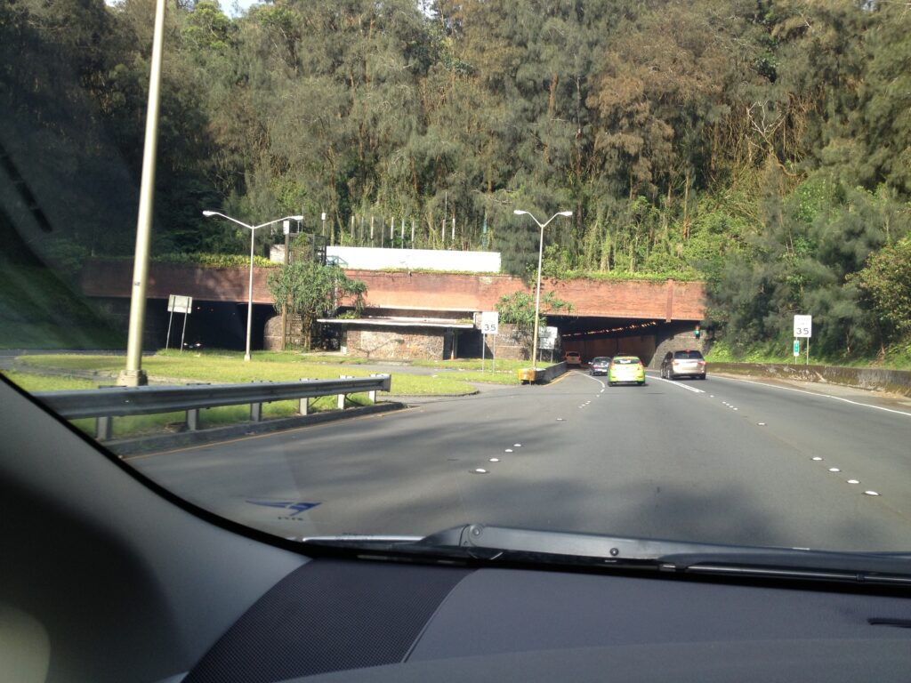
Initially known as the ‘Kalihi Tunnel’ (and often called the Likelike Tunnels,) the Wilson Tunnels are named in honor of John H Wilson. (1998 brought the completion of H-3 (and the Tetsuo Harano Tunnels – named after a longtime state highways administrator.))

© 2026 Hoʻokuleana LLC

Lyman C Newell, Queen’s lady-in-waiting, Queen Liliuokalani, Adam H Dickey & Mrs SK Kea-PP-98-13-007

Filed Under: Ali'i / Chiefs / Governance, Prominent People Tagged With: Queen Liliuokalani, Pali, Wilson Tunnel, Johnny Wilson, Lady In Waiting, Eveline Wilson, Hawaii, Liliuokalani

December 15, 2023 by Peter T Young Leave a Comment

Pelekunu

“The glimpses of Molokai which one obtains from a steamer’s deck while passing to Honolulu from San Francisco or in passing to and from Maui (along its south shore,) give the impression that the island is bleak, mountainous and desolate.”

“Skirting its (north) shores on the Hālawa, Wailua and Pelekunu sides on Wilder’s fine steamer Likelike, gives a far different picture.  For miles sheer precipices rise from the sea and tower 1,500 feet into the air.”

“Now and then, and sometimes in groups, beautiful waterfalls are seen on the face of the cliff, now falling in clear view for a couple of hundred feet, now hidden under denses masses of foliage, only to reappear further down, another silvery link In the watery thread which ends In a splash and scintillating mist in the breakers below.”  (Hawaiian Gazette, March 31, 1905)

The large windward valleys – Pelekunu, Wailau and Halawa – and Papalaua, along with all of Kalaupapa comprise the old Hawaiian Koʻolau Moku (district) of Molokai.

Literally defined, the word Pelekunu means “smelly for lack of sunshine.” (Pukui)   Being that it is such a tall and narrow valley, the sun is out for only about seven hours a day. Short days, coupled with the windward tendency for rain, creates a generally damp condition in Pelekunu.

Marion Kelly gives an alternate possibility suggesting the name Pelekunu relates to Pele, the goddess of the volcano. The area is said to be sensitive to very light earthquakes that are felt by the folks in the area, thus the name, Pelekunu, “coughing” or “grumbling” Pele.

Archaeological evidence suggests this area of Molokai was traditionally the home of the majority of early Hawaiians. The water supply was ample; ʻauwai (irrigation ditches,) loʻi kalo (wetland taro ponds) and habitation sites were found here.

“Every possible square yard was utilized for growing taro as the patches go nearly to the beach and even up the small ravines which cut the sides of the valleys. … In the matter of food, the emphasis which has been placed upon taro should not obscure the importance of fish whether from deep water or from other places and of fruits and other plant products.”

“The depth of the sea off this region prohibited the development of fish-ponds … but fishing with hook and line or with nets found rich opportunities.”  (Phelps, NPS)

The “narrowness of the gulches and their steep slopes result in the patches being no more than 12-feet on a side and the down-slope retaining wall may have to be seven-feet high.  The stream flows on one side of the gulch and is tapped at the highest placed patch, the water running successively into the lower ones.” (Phelps (1937,) NPS)

Pelekunu is an unusual ahupua‘a for several reasons. Within the Pelekunu ahupua‘a are three lele (disconnected portions of associated land) that belong to ahupua‘a on the other side of the island in the Kona District. Another unusual feature is that the ahupua‘a of Kawela actually extends up and over the mountains at the back of Pelekunu and runs into the valley.

Additionally, the ahupua‘a of Pelekunu includes not only most of the valley itself (less the extension of Kawela at the back and the lele within), but also the land of Honokaʻupu to the west as well as the small valley of Waiahoʻokalo just beyond.  (Eminger/McElroy)

The windward valleys developed into areas of intensive irrigated taro cultivation and seasonal migrations took place to stock up on fish and precious salt for the rest of the year. Kalaupapa was well known for its bountiful ʻuala (sewwt potato) crops and its fine-grained, white salt which was preferred over that from the salt ponds of Kawela and Kaunakakai.  (Strazar)

Emory (1916) describes Pelekunu Valley as the “most densely populated area of the ahupuaʻa … where we found miles and miles of huge stone terraces, witnesses of a once thriving population that must have run into the thousands.”  Taro was grown on the flat land and in the steep ravines of the valley.  (NPS)

The earliest recorded population figures we have for Molokai are those of visiting missionaries in 1823. A loose estimate of three to four thousand inhabitants in 1823 was published by Claudius S. Stewart in 1830. The Reverend Harvey Rexford Hitchcock who established the first permanent Mission Station at Kaluaʻaha in 1832, gave a census figure of 6,000 for the island.  (Strazar)

These early counts were generally taken in the field by both native school teachers and missionaries. During this period, the Reverends Hitchcock and Smith preached once a week at seven different stations from Kamaloʻo to Hālawa, and in 1833 they estimated the population of the entire island to be about 3,300.  (Strazar)

During the years around 1854, taro was raised extensively in the windward valleys and shipped as far away as Maui. Everywhere the inhabitants (of Pelekunu) were busy making baskets of ki (ti) leaves …., which they used to pack and transport … the product of their oasis, taro reduced to paʻiʻai (dry poi.)  (Strazar)

In 1898, Johnny Wilson (later Mayor of Honolulu) looked into living in Pelekunu and farming there.  Wilson’s parents’ friends included John and Lydia Dominus (Queen Liliʻuokalani) and King Kalākaua.

“We had known Mr. Wilson quite well as a young man when he was courting his wife. My husband and myself had warmly favored his suit; and, with his wife, he naturally became a retainer of the household, and from time to time they took up their residence with us.”  (Liliʻuokalani)

During her imprisonment, Queen Liliʻuokalani was denied any visitors other than one lady in waiting (Mrs. Eveline Wilson – Johnny’s mother.)  Johnny would bring newspapers hidden in flowers from the Queen’s garden; reportedly, Liliʻuokalani’s famous song Kuʻu Pua I Paoakalani (written while imprisoned,) was dedicated to him (it speaks of the flowers at her Waikiki home, Paoakalani.)

Johnny Wilson brought his wife Jennie Kini Kapahu to Pelekunu to live in 1902. The entry in Johnny’s diary for Tuesday, April 8, 1902, reads, “Arrived Pelekunu & occupied Koehana’s house”   According to Bob Krauss, Kini was “one of Hawai‘i’s premier hula dancers” and not used to country life; the Hawaiians in the valley wondered how long Kini would stick it out.

In the beginning Johnny and Kini lived at the shore, but sometime after the 1903 tsunami Johnny built Kini a house farther back in the valley.  Later, Johnny bought Kini a piano, the only one in Pelekunu.  (Krauss)

Kini did stick it out for quite a while. She helped teach the children in Pelekunu and ran their taro operation while Johnny was away. Eventually, however, Kini did leave the valley; in the summer of 1914, Kini finally got tired of the rain. She staged a one-woman mutiny and moved to a drier place on Molokai at Kamalō, where Johnny had a cattle ranch.

Wilson tried to aid the small native Hawaiian farmers by arranging for a steamer schedule to remote taro- and rice-producing areas.   When his plans for a commercial line fell through Wilson convinced the federal administration to place a post office in Pelekunu, guaranteeing regular steamer visits to deliver the mail. (Cook)

However, when his wife left (she was postmistress,) no one filled the post and the post office closed.  The steamships tried to keep regular schedules to Pelekunu to support the valley’s residents.  However, they were not regular enough and eventually others abandoned Pelekunu valley, deeming it as too isolated to remain viable in a cash economy. (Cook)

(Johnny Wilson served three times as mayor of Honolulu: from 1920 to 1927, 1929 to 1931 and from 1946 to 1954.)

In 1986, The Nature Conservancy purchased nearly 5,800-acres of Pelekunu Valley from Molokai Ranch to create a preserve to protect its natural and cultural resources.  (It contains nearly all the native Hawaiian aquatic fish, crustacean and mollusk species; in addition, 27-rare plant, 5-endemic forest bird and 2-endemic land snail species have been reported in the area.)  (TNC)

The Pelekunu Preserve is managed in partnership with the State Department of Land & Natural Resources through the Natural Area Partnership Program; due to its remote, rugged location, Pelekunu Preserve is not open to the public.

Pelekunu Preserve is bordered by four other managed natural resource areas: state-owned Pu‘u Ali‘i and Oloku‘i Natural Reserve Areas (NARs), Kalaupapa National Historic Park and the Conservancy’s Kamakou Preserve.

It is a part of the East Molokai Watershed Partnership (EMoWP); (a public-private partnership that protects more than 30,000 acres of contiguous ecosystems that range from sea level to 4,970 feet in elevation.)

© 2023 Hoʻokuleana LLC


Filed Under: Prominent People, Place Names Tagged With: Hawaii, Molokai, Halawa, Johnny Wilson, Wailau, Pelekunu

March 1, 2023 by Peter T Young Leave a Comment

Ala Wai Canal

A son of Mā’ilikūkahi (who ruled about the time Columbus crossed the Atlantic) was Kalona-nui, who in turn had a son called Kalamakua. Kalamakua is said to have been responsible for developing large taro fields in what was once a vast area of wet-taro cultivation on Oʻahu: the Waikiki-Kapahulu-Mōʻiliʻili-Mānoa area.

The early Hawaiian settlers gradually transformed the marsh above Waikīkī Beach into hundreds of taro fields, fish ponds and gardens.  For centuries, springs, taro lo‘i, rice paddies, fruit and vegetable patches, duck ponds and fishing areas were a valuable means of subsistence for native Hawaiians and others.

Formerly the home of Hawaiian royalty, including King Kamehameha, Waikīkī, meaning “spouting waters,” once covered a much broader area than it does today.

The ahupuaʻa, or ancient land division, of Waikīkī actually covered the area extending from Kou (the old name for Honolulu) to Maunalua (now referred to as Hawai’i Kai).

Waikīkī’s marshland, the boundaries of which changed seasonally, once covered about 2,000-acres (about four times the size of Waikīkī today) before the marshes were drained.

During the first decade of the 20th-century, the US War Department acquired more than 70-acres in the Kālia portion of Waikīkī for the establishment of a military reservation called Fort DeRussy.

They drained and filled the area, so they could build on it.  Thus, the Army began the transformation of Waikīkī from wetlands to solid ground.

In the early-1900s, Lucius Pinkham, then President of the Territorial Board of Health and later Governor, developed the idea of constructing a drainage canal to drain the wetlands, which he considered “unsanitary.”  This called for the construction of a canal to reclaim the marshland.

The Waikīkī Reclamation District was identified as the approximate 800-acres from King and McCully Streets to Kapahulu Street, near Campbell Avenue down to Kapiʻolani Park and Kalākaua Avenue on the makai side (1921-1928.)

The dredge material not only filled in the makai Waikīkī wetlands, it was also used to fill in the McKinley High School site.

During the 1920s, the Waikīkī landscape would be transformed when the construction of the Ala Wai Drainage Canal, begun in 1921 and completed in 1928, resulted in the draining and filling in of the remaining ponds and irrigated fields of Waikīkī.

The initial planning called for the extension of the Ala Wai Canal past its present terminus and excavate along Makee Island in Kapiʻolani Park, connecting the Canal with the ocean on the Lēʻahi side of the project.

However, funds ran short and this extension was contemplated “at some later date, when funds are made available”; however, that never occurred.

By 1924, the dredging of the Ala Wai Canal and filling of the wetlands stopped the flows of the Pi‘inaio, ‘Āpuakēhau and Kuekaunahi streams running from the Makiki, Mānoa, and Pālolo valleys to and through Waikīkī.

Walter F. Dillingham’s Hawaiian Dredging Company dredged the canal and sold the material he had dredged to create the canal to build up the newly created land.  The canal is still routinely dredged.

During the course of the Ala Wai Canal’s initial construction, the banana patches and ponds between the canal and the mauka side of Kalākaua Avenue were filled and the present grid of streets was laid out.  These newly created land tracts spurred a rush to development.

With construction of the Ala Wai Canal, 625-acres of wetland were drained and filled and runoff was diverted away from Waikīkī beach.  The completion of the Ala Wai Canal not only gave impetus to the development of Waikīkī as Hawai‘i’s primary visitor destination, but also expanded the district’s potential for residential use.

During the period 1913-1927, the demand for housing in Honolulu grew along with the city’s population.  Waikīkī helped satisfy this demand; the large kamaʻāina landholdings virtually disappeared and the area started to be subdivided.

Before reclamation, assessed values for property were at about $500-per acre and the same property was reclaimed at ten cents per square foot, making a total cost of $4,350-per acre.  The selling price after reclamation, $6,500 to $7,000-per acre, showed the financial benefit of the reclamation efforts.

From an economic point of view, without the Ala Wai Canal, Waikīkī may never have developed into the worldwide tourist attraction it is today.

In 1925, the City Planning Commission requested the citizens of Honolulu to submit suitable Hawaiian names for the renaming of the Waikīkī Drainage canal; twelve names were suggested.

The Commission felt that Ala Wai (waterway,) the name suggested by Jennie Wilson was the “most euphonic”.  (An engineer with the Planning Commission was quick to note that, “the fact that Mrs. Wilson is the mayor’s wife had nothing to do with the choice of the name.”)

In November 1965, a storm, classified as a 25-year event, overflowed the Ala Wai Canal banks and flooded Ala Wai Boulevard.

Ala Wai Canal and the historic walls lining the canal are owned by the State of Hawaiʻi. The promenades on the mauka side of the Ala Wai Canal are owned by the State, and by, Executive Ordered to the City and County of Honolulu, the promenades on the makai side are owned by the City.

The promenades on both sides of the Ala Wai Canal are maintained by the City Department of Parks and Recreation.  The Ala Wai Canal is listed in the National and State registers of historic places.

© 2023 Hoʻokuleana LLC

Filed Under: Economy, General, Place Names Tagged With: Waikiki, Kalamakua, Oahu, Pinkham, Mailikukahi, Ala Wai Canal, Johnny Wilson, Palolo, Manoa, Dillingham, Hawaiian Dredging, Fort DeRussy, Ala Wai, Hawaii, Makiki

April 20, 2022 by Peter T Young Leave a Comment

John (Johnny) Henry Wilson

His story starts in 1820, when his great grandfather, Andrew Henri Blanchard (captain of the brig Thaddeus that brought the first company of Protestant missionaries to Hawaiʻi) married Koloa, a Molokaʻi chiefess.

Fast forward a couple generations and John “Johnny” Henry Wilson was born December 15, 1871 to Charles Burnett (CB) Wilson and Eveline (Townsend) Wilson.

His parents’ friends included the John and Lydia Dominus and Kalākaua.  “We had known Mr. Wilson quite well as a young man when he was courting his wife. My husband and myself had warmly favored his suit; and, with his wife, he naturally became a retainer of the household, and from time to time they took up their residence with us.”  (Liliʻuokalani)

During her imprisonment, Queen Liliʻuokalani was denied any visitors other than one lady in waiting (Mrs. Eveline Wilson – Johnny’s mother.)  Johnny would bring newspapers hidden in flowers from the Queen’s garden; reportedly, Liliʻuokalani’s famous song Kuʻu Pua I Paoakalani (written while imprisoned,) was dedicated to him (it speaks of the flowers at her Waikiki home, Paoakalani.).

Johnny Wilson attended Fort Street School and St. Alban’s College (forerunners to the present McKinley and ʻIolani High Schools.)

He had a short stint working for Dillingham’s Oʻahu Railway and Land Company – there he had interest in being a civil engineer.  In 1891, with financial support from Liliʻuokalani, Wilson was in the first class of Stanford University – there, he was known as “Kanaka” Wilson.

Back in Hawaiʻi, in 1897, Johnny and fellow Stanford student Louis Whitehouse won the bid to expand and construct a ‘carriage road’ over the Pali.  Ground was broken on May 26, 1897 and the road was opened for carriages on January 19, 1898.  (Later, the Pali tunnels were completed and the old road abandoned – on August 1, 1961, Mrs. Jennie Wilson (his wife) led the dedication ceremonies.)

Wilson and Whitehouse also won the contract to extend Benjamin Dillingham’s railroad around Kaʻena Point.  To keep the bid low, they carried laborers, equipment and supplies to the site and freight back by boat – on October 14, 1897, the place where the first Japanese laborers landed for this job is known to this day as “Yokohama Beach.”  (ascehawaii)

He and his wife, Jennie “Kini” Kapahu (previously a court dancer) toured the continent in 1900 with their Hawaiian Village hula troupe.  (Kini Kapahu claimed that she was the ‘first girl to leave Hawai‘i to go as a dancer in the mainland’.)

Wilson got involved with politics and is credited as being the most important Democrat in the first half of 20th-century Hawaiʻi; his name is used with Jack Burns in the party movement.  He was in a meeting on April 30, 1900 that organized the Democratic Party of Hawaiʻi.

His initial political campaign in 1918 met with failure.  Mayor Joe Fern, Honolulu’s first Mayor, appointed his good friend Wilson as road supervisor for the Honolulu district.  Later, Wilson succeeded Fern as Mayor, following the illness and death of Fern.

Fern died on February 20, 1920; the Honolulu Board of Supervisors voted in Wilson on February 25, and he was sworn in as Mayor on February 29.  He would serve three stints as mayor: 1920 to 1927, 1929 to 1931 and 1946 to 1954.  (From 1941 to 1946, he was Director of Public Works.)

Honolulu Hale was an idea started by Joseph J Fern, but he died before it came to fruition.  Mayor Wilson carried on Fern’s dream; Honolulu Hale was finally completed in 1928.

Wilson foresaw the growth on the windward side and excavation commenced on January 8, 1954 on the “Kalihi Tunnel.”  Near the end of May 1954 tunnel excavation transitioned from rock to “earth” – in the summer of 1954, several tunnel collapses and surface sinkholes subsequently led to a large collapse on August 14 that killed five construction workers.

Construction ceased while they considered alternative methods of completion.  Tunnel excavation restarted in February 1956 and the first half-mile tunnel was open to two-way traffic in 1958; both tunnels were fully operational by November 1960.

Initially known as the ‘Kalihi Tunnel,’ and often called the Likelike Tunnels, they are named in honor of John H Wilson.  (1998 brought the completion of H-3 (and the Tetsuo Harano Tunnels – named after a longtime state highways administrator.))

In addition to the John H Wilson Tunnels, the John H Wilson Elementary School on Kilauea Avenue and the adjoining Wilson Playground at Papakōlea in Waiʻalae Nui Valley are named for Wilson.

Johnny Wilson passed away on July 2, 1956 at the age of 84.

© 2022 Hoʻokuleana LLC

Filed Under: Prominent People Tagged With: Wilson Tunnel, Johnny Wilson, Yokohama, Joe Fern, Likelike Highway, Hawaii, Paoakalani, Waikiki, Honolulu, Oahu, Liliuokalani, Pali

January 9, 2022 by Peter T Young 1 Comment

Clarence Hyde Cooke Home

Clarence Hyde Cooke was born April 17, 1876 in Honolulu, Hawaii, the second son of Charles Montague Cooke and Anna Rice Cooke (and grandson of missionaries Amos Starr Cooke and William Harrison Rice.)  He graduated from Punahou (1894,) and attended, but did not graduate from Yale.

He married Lily Love, daughter of Robert Love on August 11, 1898; they had eight children: Dorothea, Martha, Anna, Clarence Jr, Harrison, Alice, Robert and John.

Cooke began his business career in Honolulu with Hawaiian Safe Deposit & Trust Co, in 1897.  The next year he was at Bank of Hawaiʻi and about 10-years later (1909,) he succeeded his father as president of the bank and became Chairman in 1937.

In 1932, the Cooke’s built a home in Nuʻuanu (unfortunately, Lily died the next year.)   The home was designed by Hardie Phillip, one of the associates of the New York architectural firm of Mayers, Murray and Phillip, the successor firm of Bertram Goodhue and Associates (who also designed the C Brewer Building, Governor Carter’s residence and others.)

The home has the distinctive double-pitched ‘Dickey Roof’ (following the signature element of architect CW Dickey.)  The 24-room Cooke mansion (including 10-bedrooms, 7-full bathrooms and two half-baths) is noted for its sprawling spaciousness, numerous lanai, Hawaiian hipped roof and lush grounds.

Well-planned, well-crafted and paying high attention to detail, the house was built for, and was known for, lavish, opulent entertainment. As such, it epitomizes the finest traditions in upper class residential design in Hawaii for its period.  (HHF)

The two-story white-washed brick and frame residence features an asymmetrical plan which lends the building a sense of sprawling informality. The house is laid out with two wings running perpendicularly in opposite directions off a formal entry hall.  A number of lanai extend out from the principal rooms on both the ground and second floors.

A vine covered porte-cochere, shaded by a banyan tree, extends diagonally out from the intersection of the makai (left) wing and the entry area. It has segmental arched openings, and is paved with Chinese granite blocks. A tiled fountain is in the corner of the porte-cochere.  (NPS)

Cooke lived there until his death on August 2, 1944.  He bequeathed the estate to the Academy of Arts (architect Hardie Phillip also designed the Honolulu Academy of Arts building on Beretania.)

The Academy later (1945) sold the home to Alfred Lester and Elizabeth ((daughter of Lincoln L McCandless) Marks.   (Since then, the property has been generally referred to as the “Marks Estate.”)

At about this time, Johnny Wilson, the builder of the original carriage-road over the Pali, was re-elected Mayor (1948.)  One of his first actions was to seek approval from the Territorial Legislature for an increase in the gasoline tax to pay for a tunnel in Kalihi Valley.

Wilson argued the Kalihi alternative would serve the entire windward side, while the Pali would merely be a private access road for Kailua residents.

The Territorial legislature turned down Wilson’s 1949 gas tax proposal for the Kalihi tunnel.  That same year, Governor Ingram M Stainback looked to build the Pali Highway alignment, instead.  (ASCE)  (This alignment would cut through the Marks Estate.)

Marks went to court to block the proposed highway.  After lengthy legal battles, in 1956, the government bought 7-acres of the 17-acre estate, and also bought the home and other improvements.

(On May 11, 1957, the Honolulu-bound tunnels on Pali Highway were opened; the Pali Tunnels were fully-functional in 1959.  The Kalihi ‘Wilson Tunnels’ were also later built and fully operational by November 1960.)

Although the State condemned and bought the property and home, they allowed Marks to continue to live there (the Marks paid $1,500-per month for the first three years, then $500-per month until 1976, then the State took over the property.)

After that, the now-defunct Hawaiʻi Institute for Management and Analysis in Government, part of the Department of Budget and Finance, acquired the property for a research, training and conference center.  (The Institute was later absorbed into DBEDT.)  (Danninger)

The State government then used the estate for office space, conferences and special events, and it was put on the National Register of Historic Places in 1986.

After trying to sell it for years, the State finally auctioned off the property in 2002. Reportedly, it had been appraised for $4.5-million, but labor union Unity House Inc bought it for $2.5-million.

Real property tax records note a subsequent (2006) conveyance of the property for $4.41-million.  Later listings note the property has since been on and off the market.

© 2022 Hoʻokuleana LLC


Filed Under: Buildings, Economy, Prominent People Tagged With: Hawaii, Oahu, Pali, Nuuanu, Marks Estate, Alfred Marks, Wilson Tunnel, Johnny Wilson, Clarence Hyde Cooke

  • 1
  • 2
  • Next Page »

Images of Old Hawaiʻi

People, places, and events in Hawaiʻi’s past come alive through text and media in “Images of Old Hawaiʻi.” These posts are informal historic summaries presented for personal, non-commercial, and educational purposes.

Info@Hookuleana.com

Connect with Us

  • Email
  • Facebook
  • LinkedIn
  • Twitter
  • YouTube

Recent Posts

  • Lāhainā Canal
  • Boondocks
  • About 250 Years Ago … Battle of Kings Mountain
  • Cow Laws
  • Palea and the Pinnace
  • Yick Lung
  • Early Days at Kamehameha Schools

Categories

  • Ali'i / Chiefs / Governance
  • Buildings
  • Missionaries / Churches / Religious Buildings
  • Hawaiian Traditions
  • Military
  • Place Names
  • Prominent People
  • Schools
  • Sailing, Shipping & Shipwrecks
  • Economy
  • Voyage of the Thaddeus
  • Mayflower Summaries
  • American Revolution
  • General

Tags

Albatross Al Capone Ane Keohokalole Archibald Campbell Bernice Pauahi Bishop Charles Reed Bishop Downtown Honolulu Eruption Founder's Day George Patton Great Wall of Kuakini Green Sea Turtle Hawaii Hawaii Island Hermes Hilo Holoikauaua Honolulu Isaac Davis James Robinson Kamae Kamaeokalani Kameeiamoku Kamehameha Schools Lalani Village Lava Flow Lelia Byrd Liberty Ship Liliuokalani Mao Math Mauna Loa Midway Monk Seal Northwestern Hawaiian Islands Oahu Papahanaumokuakea Marine National Monument Pearl Pualani Mossman Quartette Thomas Jaggar Volcano Waikiki Wake Wisdom

Hoʻokuleana LLC

Hoʻokuleana LLC is a Planning and Consulting firm assisting property owners with Land Use Planning efforts, including Environmental Review, Entitlement Process, Permitting, Community Outreach, etc. We are uniquely positioned to assist you in a variety of needs.

Info@Hookuleana.com

Copyright © 2012-2024 Peter T Young, Hoʻokuleana LLC

Loading Comments...