In early nineteenth-century France, Château de Fontainebleau, the Forest of Fontainebleau, became a sanctuary for the growing leisure classes, for whom a train ride from Paris was an easy jaunt.
Called “the branch-office of Italy”, the Forest of Fontainebleau spread across 42,000 acres of dense woods with meadows, marshes, gorges, and sandy clearings. Quiet hamlets ringed the forest.
It was to one of those villages, Barbizon, that artists journeyed beginning in the 1820s, with a promise of room and board at the newly established inn Auberge Ganne. The Auberge provided lodging for these pioneering painters of nature came to be called the Barbizon School and they collectively shared a recognition of landscape as an independent subject. (Met Museum)
In America, the Hudson River School was America’s first true artistic fraternity. Its name was coined to identify a group of New York City-based landscape painters that emerged about 1850 under the influence of the English émigré Thomas Cole (1801–1848) and flourished until about the time of the Centennial.
Several of the artists built homes on the Hudson River. The term “Hudson River School” in the 1870s fairly characterizes the artistic body, its New York headquarters, its landscape subject matter, and often literally its subject. (Met Museum)
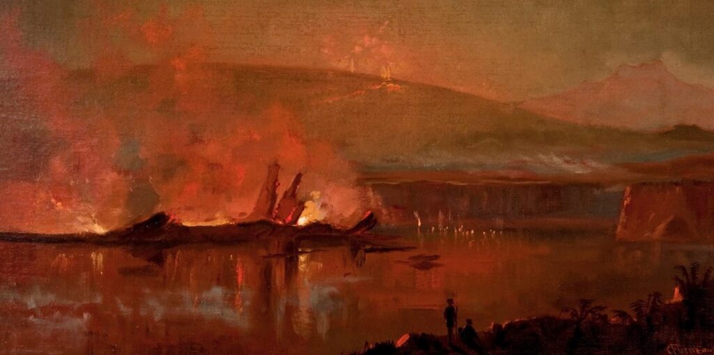
In the Islands, there was the Volcano School.
The Volcano School was a generation of mostly non-native Hawaiian painters who portrayed Hawaiʻi Island’s volcanoes in dramatic fashion during the late 19th century. (NPS HAVO)
In the 1880s and 1890s, Mauna Loa kicked off an eruption that brought lava closer to the town of Hilo than ever before. Hawai‘i residents and tourists alike flocked to the Big Island for a chance to see the orange and red glow over the city of Hilo.
This was in the days before color photography – painters were among the most eager to witness and recreate the explosive lava plumes and vibrant flows. (HuffPost)
A distinctive and recognizable school of Hawaiian painting developed; it is perhaps best exemplified by Jules Tavernier’s depictions of craters and eruptions. Other artists, fresh from exposure to the current trends in Europe and America, reinterpreted the lush light and varied landscape of Hawai‘i to create a distinctive body of work.
With the dawning of the twentieth century, art in Hawai‘i reflected the diminishing isolation of the islands and the emergence of a multicultural modernist tradition. (Forbes)
Author and humorist Mark Twain, on assignment for the Sacramento Daily Union, described seeing Kīlauea at night: “…the vast floor of the desert under us was as black as ink, and apparently smooth and level …”
“… but over a mile square of it was ringed and streaked and striped with a thousand branching streams of liquid and gorgeously brilliant fire! Imagine it— imagine a coal-black sky shivered into a tangled network of angry fire!”
Kīlauea was such a popular subject for painters that a group emerged called “the Volcano School,” which included well-known Hawai‘i painters Charles Furneaux, Joseph Dwight Strong, and D. Howard Hitchcock.
Jules Tavernier (French 1844–1889) was arguably the most important Volcano School painter; he arrived in Hawai‘i in December of 1884. He created paintings that came to characterize the genre with dramatic scenes of molten lava bubbling under diffused moonlight, jagged black cliffs, and fiery glows, as seen in his nocturnal view of Kīlauea. (HoMA)
Tavernier had lived in San Francisco with roommate Joseph Dwight Strong. In October 1882 Joseph Dwight Strong, born in Connecticut and at age two came to the Islands with his New England missionary father (American 1852–1899), returned to the Islands with his wife Isobel on a commission to paint landscapes for shipping magnate John D Spreckels, son of the Sugar King Claus Spreckels. (Theroux) (Strong’s step-father-in-law was Robert Louis Stevenson.)
David Howard Hitchcock, grandson of American missionaries (American 1861–1943), is perhaps one of the most important and loved artists from Hawaiʻi. Although born and raised in Hawaiʻi, he left the islands to study art in San Francisco and Paris.
Before his formal training abroad, Hitchcock was inspired by other Volcano School painters and was encouraged by Jules Tavernier to endeavor life as an artist. Hitchcock admits to following Tavernier and Joseph Strong around, ‘like a parasite.’ (NPS HAVO)
“Hitchcock was early hailed as ‘our island painter’ and his early canvases met an enthusiastic reception in Hilo and Honolulu. The Honolulu press commented on them at length. His early work, up to his European trip in 1890, shows great indebtedness to (Jules) Tavernier…” (Forbes)
Charles Furneaux (American 1835–1913), showcased the fiery Hawai‘i volcano scenes that have intrigued viewers since he began painting them in the late 19th century. Furneaux’s paintings are described as “among the most sublime depictions of smoldering lava pools, lightning bolts over the ocean, steaming vents and heavy clouds signaling the active presence of the volcano.” (HoMA)
Painter and printmaker Ambrose McCarthy Patterson (Australian 1877–1966) arrived in Hawai‘i on a stopover in 1916 and remained for the next 18 months. Patterson was described as having particular interest in Kīlauea, incorporating the subject into many of the paintings and block prints he produced during his time here. (HoMA)
Other Volcano School artists include Ernst William Christmas (Australian 1863–1918), Constance Frederica Gordon-Cumming (Scottish 1837–1924), Ogura Yonesuke Itoh (Japanese 1870–1940), Titian Ramsey Peale (American 1799–1885), Louis Pohl (American 1915–1999), Eduardo Lefebvre Scovell (British 1864–1918), William Pinkney Toler (American 1826–1899), William Twigg-Smith (New Zealander 1883–1950) and Lionel Walden (American 1861–1933).