Images of Old Hawaiʻi

  • Home
  • About
  • Categories
    • Ali’i / Chiefs / Governance
    • American Protestant Mission
    • Buildings
    • Collections
    • Economy
    • Missionaries / Churches / Religious Buildings
    • General
    • Hawaiian Traditions
    • Other Summaries
    • Mayflower Summaries
    • Mayflower Full Summaries
    • Military
    • Place Names
    • Prominent People
    • Schools
    • Sailing, Shipping & Shipwrecks
    • Voyage of the Thaddeus
  • Collections
  • Contact
  • Follow

January 30, 2022 by Peter T Young Leave a Comment

Palikū

In 1837, Samuel Northrup Castle arrived in Honolulu as a missionary.  He left Hawaiʻi for a short time, then returned as a businessman for the mission.

With Amos Cooke, he founded Castle & Cooke Company, in 1851 – it grew into being one of Hawaiʻi’s “Big Five” companies.

One of his ten children would surpass him as a businessman; James Bicknell Castle was born November 27, 1855 in Honolulu to Samuel and Mary (Tenney) Castle.

Harold Kainalu Long Castle was born July 3, 1886 in Honolulu, son of wealthy landowner James Bicknell Castle and Julia White, and grandson of Castle & Cooke founder Samuel Northrop Castle.

In 1917, Harold Castle purchased about 9,500-acres of land on the windward side of Oʻahu, in what became Kāneʻohe Ranch.  Later acquisitions added several thousand acres of land, with holdings from Heʻeia to Waimanalo.  The Castle fortune was built on ranching and dairying.

The family had land in Waikīkī, as well; it was formerly called Kalehuawehe. The surf break ‘Castles’ is named after the Castle family’s three-story beachfront home; they called it Kainalu.  They later sold it to the Elks Club, who now use part of the site and lease the rest to the Outrigger Canoe Club.

With the widening and paving of Old Pali Road in 1921 (which helped to initiate the suburban commute across the Koʻolau,) the Castles realized that the Windward side of the island of Oʻahu was a beautiful place to live and could become a vibrant community.  (The Pali Highway and its tunnels opened in 1959.)

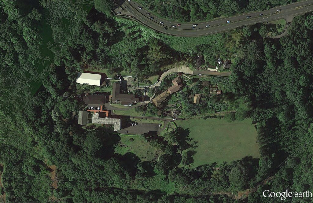
In 1927, Harold and his wife Alice Hedemann Castle built a home for themselves that overlooked much of their land holdings.  It was just below the hairpin turn, below the Pali.

They called the home Palikū (Lit., vertical cliff.)

Architect Bertram Grosvenor Goodhue designed it (Goodhue’s other work included Los Angeles Central Public Library, the Nebraska State Capitol and Saint Thomas Church, New York City;) there were 27 rooms with ornamental ironwork, redwood beams, plumbing and electricity – one of the first buildings on the windward side of the island to have those amenities. (Brennan, Honolulu Advertiser)

In 1946, the Castles sold the 22-acre Palikū to the Catholic Church for the Saint Stephen Seminary (the seminary closed in 1970; it’s now the St. Stephen’s Diocesan Center (the driveway is makai, just below the scenic lookout at the hairpin turn.))

St. Stephen’s Seminary was shut down for a time after a mysterious occurrence in October 1946.

Some suggest the seminary was haunted; when one night there were methodical clicking and tapping sounds; invisible pressure on a person in bed; dishes, pots and pans strewn all over – they suggest it was “diabolical obsession.”  Later, “I understand there was some kind of a blessing done,” said Bishop Joseph Ferrario, the retired bishop of Honolulu. (honoluluadvertiser)

After the seminary’s ultimate closure, the facility was transformed into a diocesan center housing various offices of the diocesan curia (a diocesan center (chancery) is the branch of administration which handles all written documents used in the official government of a Roman Catholic diocese.)

The former Castle home also serves as the residence of the Bishop of Honolulu, Clarence Richard Silva, popularly known as Larry Silva (born August 6, 1949), bishop of the Roman Catholic Church. He is the fifth Bishop of Honolulu, appointed by Pope Benedict XVI on May 17, 2005.

In 1962, Castle founded the Harold KL Castle Foundation. On his death in 1967, he bequeathed a sizeable portion of his real estate assets to the Foundation.

Throughout his life, Castle donated land for churches of all different denominations because he felt that churches would bring congregations, congregations would bring stability, and that would benefit the community that was growing around them.

Mr. Castle also donated land and money to Hawaii Loa College, Castle Hospital, ʻIolani School, Castle High School, Kainalu Elementary School and the Mōkapu peninsula land, which would become the Kāneʻohe Marine Corps Base.

His foundation has annually provided millions of dollars in support to worthy causes, a good chunk of it going to the windward side of Oʻahu.

© 2022 Hoʻokuleana LLC

Filed Under: Buildings, Prominent People, Economy Tagged With: Harold Castle, Koolaupoko, Kaneohe Ranch, Windward, Mokapu, Paliku, Hawaii, Castle and Cooke, Oahu, Kaneohe, Kailua, Kainalu

January 21, 2022 by Peter T Young Leave a Comment

“Ah! What delicious-looking crabs you have here!”

So said the visitor to Ke Awa Lau o Puʻuloa – but he wasn’t speaking of crustaceans, he was speaking of the fishermen he saw as “fat crabs”, that is, a dainty morsel.

He was Mikololou, a man-eating shark from the Kaʻū district on the Island of Hawaiʻi.

He was part of a large company of sharks who came to visit from Hawaiʻi, Maui and Molokaʻi. Most of these had human relatives and were not desirous of eating human flesh, but among them were some who disregarded the relationship, and learned to like them.

The sharks had planned to make a circuit of the islands and perhaps later to visit Kahiki. They stopped at Puʻuloa (Pearl Harbor.)

Kaʻahupahau, hearing those words, knew at once that some of the strangers were man-eaters. Guardians of the area, she and her brother Kahiʻuka went into action to protect the fishermen.

But Kaʻahupahau could not distinguish between the good and the bad sharks; she then she changed into the form of a great net and hemmed in her visitors while the fishermen who answered her signal came to destroy them.

Her brother Kahiʻuka struck at intruders with his tail, one side of which was larger than the other; the fishermen hauled in the nets to shore and Mikololou was cast upon the shore with the evil doers, where they were left to die of the intense heat.

All but Mikololou were soon dead; though his body died his head lived on and as the fishermen passed to and from their work, his eyes followed them and tears rolled down his face. At last his tongue fell out. Some children playing nearby found it. They picked it up and cast it into the sea.

Now Mikololou’s spirit had passed out of his head into his tongue and as soon as he felt the water again he became a whole shark. With a triumphant flop of his tail, he headed for home to join his friends again. When Kaʻahupahau saw him, it was too late to prevent his departure.

“Mikololou lived through his tongue,” or, as the Hawaiians say, “I ola o Mikololou i ka alelo.” This saying implies that however much trouble one may have, there is always a way of escape.

Kaʻahupahau lived in an underwater cave in Honouliuli lagoon (West Loch.) Kahiʻuka lived in an underwater cave off Mokuʻumeʻume (Ford Island) near Keanapuaʻa Point at the entrance of East Loch

Kaʻahupahau may mean “Well-cared for Feather Cloak” (the feather cloak was a symbol of royalty). Kahiʻuka means “Smiting Tail”; his shark tail was used to strike at enemy sharks; he also used his tail to strike fishermen as a warning that unfriendly sharks had entered Puʻuloa.

Such guardian sharks, which inhabited the coastlines of all the islands, were benevolent gods who were cared for and worshiped by the people and who aided fishermen, protected the life of the seas, and drove off man-eating sharks.

Pukui notes Kaʻahupahau in ʻŌlelo Noʻeau: Hawaiian Proverbs and Poetical Sayings, No. 105: “Alahula o Puʻuloa, he alahele na Kaʻahupahau”: “Everywhere in Puʻuloa is the trail of Kaʻahupahau.”

“Said of a person who goes everywhere, looking, peering, seeing all, or of a person familiar with every nook and corner of a place.” Kaʻahupahau was noted for traveling about, vigilantly guarding her domain against man-eating invaders.

Puʻuloa also was home to Komoawa, (or Kamoawa,) a large shark who was Kaʻahupahau’s watcher. His cave, called Keaaliʻi, was at the entrance of Puʻuloa. (Thrum, Hawaii-edu) Kualiʻi guards the entrance to Pearl Harbor, while the home of Kaʻahupahau is deeper into Honouliuli lagoon.

Years later, the US Navy, having acquired Pearl Harbor, was working to expand the facilities. This included dredging the channel, adding a coal station and construction of a drydock.

“The dredging of the Pearl Harbor channel was begun long before the drydock was more than desultorily talked of – in 1900. It took many years to deepen, straighten and widen the channel into the lochs sufficiently for a man of war to enter.”

“But the work progressed steadily if slowly, and on December 14, 1911, the cruiser California steamed from Honolulu to the entrance to Pearl Harbor, and then, turning her gray nose inward, proceeded majestically through the still tortuous channel and dropped her anchor off the dry dock site.” (Hawaiian Gazette, November 24, 1916)

The drydock was to be the “Largest In (the) World – Less than a decade will have elapsed between the beginning of the great work and its completion.”

“And when the Pearl Harbor drydock is finished it will be the largest and the finest in the world, capable of accommodating any vessel now built or building, or that probably ever will be built by the United States.” (Hawaiian Gazette, November 24, 1916)

But, during construction, disaster occurred. “Much progress had at that time been made on the construction of the drydock, and success seemed assured. But the contractors had been having trouble with the bed of the drydock … it suddenly blew up with a tremendous explosion. No lives were lost, although there were several narrow escapes.”

“But the work of years had been wrecked … pressure had forced the bottom of the drydock up until it literally burst (on February 17, 1913.”) (Hawaiian Gazette, November 24, 1916)

“For a time it was feared that the entire project might have to be abandoned. But Uncle Sam’s engineers refused to be defeated by natural forces, and finally, after long experiment, mean were found for anchoring the bottom of the drydock.”

“Admiral Harris was one of the board that came to Hawaii to investigate the causes for the explosion and try to find a way of preventing future disasters of similar nature.” (Hawaiian Gazette, November 24, 1916)

They cannot say they were not forewarned. “While at work three Hawaiian fishermen come to where we were working, one of whom was aged, who asked me what we were doing there.

‘Digging a hole 50 feet deep’ was the reply. He then told me to move away from there; and when asked why, he said, ‘These places are tabu; they belong to shark god, name Kaʻahupahau.’” (Richards (a worker on the drydock project,) Navy-mil)

“The old man was watching my men working, and talking to them. Again he came over to me with tears in his eyes and asked me to quit digging ‘til my boss came. “I told him, I can’t do that.” They stayed there several hours, then he said to me that, ‘You people will be punished severely.’” (Richards, Navy-mil)

“Several years ago, some will remember, when work started on the Pearl Harbor naval dry dock, some of the Hawaiians said the location chosen would disturb a “shark god” who would be affronted and they prophesied dire disasters.”

“The work was started and there came a collapse. The forecasters of trouble were prophets. Changes were made in plans and locations.” (Maui News, June 9, 1922)

Merely a coincidence? Some think not.

One of the workers on the project noted, “As we went along pumping the water out of the dock, we pumped out five feet and cleaned the side and plastered and corked all the leak, 15 to 20 days and then pumped till we got to the bottom which was full of mud and in the middle of the dock where I went through a cave of nine feet diameter.”

“Mr. Hartman, assistant boss, found a backbone of a big shark, 14′ 4″ long. I came by where they were working when Mr. Hartman said to me, ‘You certainly got the shark. Here it is.’” (Richards, Navy-mil) (The Story of Mikololou is from Wiggins, Beckwith)

© 2022 Hoʻokuleana LLC


Filed Under: Hawaiian Traditions, Military, Place Names Tagged With: Kaahupahau, Shark, Mikololou, Hawaii, Oahu, Pearl Harbor, Ke Awa Lau O Puuloa, Drydock

January 20, 2022 by Peter T Young Leave a Comment

Laniākea

The YWCA of Oʻahu is the oldest continuous service organization devoted to women and children in Hawaiʻi; in 1900, a small group of women met at Mrs. BF Dillingham’s home at Arcadia on Punahou Street to organize the YWCA.

From the beginning, the YWCA was organized to provide the working women of Honolulu a safe place to build friendships, develop or maintain solid values and learn skills to become more productive members of the community; but over the years, the vehicles for accomplishing those goals have changed in response to the times.

In 1904, the headquarters was housed in the Boston Building on Fort Street.  YWCA girls’ basketball team competed with teams from Oʻahu College (Punahou Schools) and Kamehameha.   Engleside (the first boarding home located at 251 Vineyard) opened and was jointly operated with the YMCA.

By 1906, when it joined the YWCA of the USA, recreational and athletic programs including tennis and swimming classes had been added.  The first YWCA residence for young working women, The Homestead (the former Castle Estate on King Street,) was opened and addressed community concerns over the lack of safe and affordable housing accommodations in Hawaiʻi.

“The YWCA of Honolulu has its rooms in the Boston building, on Fort street, and while not as aggressive as their bretheren, are nevertheless filling a much-needed niche in the community for the comradeship and comfort of an increasing body of young women coming as strangers in a strange land. In connection with its work a home is maintained on King street, of the Castle Estate, designated the Homestead, for the benefit of members and other bachelor maids.”   (Thrum, 1914)

In 1914, the first Business Women’s Club was established.  By 1917, even the Queen was a member of the YWCA.  The Red Cross had moved into the YWCA and a worker had been hired to help Japanese picture brides.

In 1921, the Atherton family gifted their near-downtown residence, Fernhurst, to the YWCA in memory of their daughter, Kate, and in tribute to her deep interest in the welfare of girls.  The original Fernhurst served as a temporary home for as many as 10,000 young working women.

As membership and programs grew, a headquarters was needed.  Several downtown locations were considered.  They settled on a site on Richards Street across from the ʻIolani Palace grounds.

Noted architect, Julia Morgan (best known as the architect of Hearst Castle in California,) was hired and the new headquarters, Laniākea, “was designed and erected from two thousand miles away.”

Laniākea was the first building of architectural significance in Hawaiʻi to be designed by a woman.  Constructed in 1927, it was developed and designed by women at a time in history when there were few opportunities for females to excel in male dominated professions.

Ms. Morgan designed over 700-buildings during her 47-year career and ranked the Honolulu YWCA as one of her top ten favorite projects.   It immediately became a Honolulu landmark.

The building’s construction was a crowning achievement for the YWCA of Honolulu, inspiring successive generations of women to rededicate themselves to the cause of community service.

The building features the tile floors, roofs, courtyards, and arches characteristic of the Mediterranean style, which the architect chose to adapt to the climate, conditions and materials of Hawaiʻi.

Morgan regarded the structure as architecturally “frank and sincere.”  She was not given to meaningless ornamentation, yet there is considerable attention to detail, such as the metal ironwork in the balconies overlooking the courtyard and the pool.

Sara Boutelle (an architectural historian) judged the Laniākea swimming pool “the most effective of all her YWCA pools,” attributing its success to the architect’s understanding of the contribution of public recreational space to the civic culture and busy lives of women.

The “Richards Street Y,” as it is affectionately known, was a meeting place for women of all generations.  Popular activities were sewing and lace-making lessons, Chinese cooking classes, girls basketball and ballet.

From a place to make tea, eat safely and quietly in the city, and take naps, to a place to make the teapot, close a deal over lunch and swim laps, the YWCA of Oʻahu has been the place for women in Hawaiʻi to find support and encouragement for over 100-years.

Today, the YWCA of Oʻahu is still guided by the core concepts of the YWCA’s mission.  Those concepts are to create opportunities for growth, leadership and power for women and girls, and to work for peace, justice, dignity, respect and the elimination of racism for all people.  (Lots of information and images here came from the YWCA website.)

© 2022 Hoʻokuleana LLC


Filed Under: Economy, General, Buildings, Prominent People Tagged With: Laniakea, Atherton, Julia Morgan, Hawaii, Oahu, YWCA, Fernhurst

January 19, 2022 by Peter T Young 1 Comment

Frederick C Ohrt

Honolulu’s public water system is one of the oldest, if not the oldest, under the American flag west of the Mississippi River. The first unit, installed, paid for and operated by the government, was in service on March 31, 1848.  (Nellist)

At that time, whale products were in high demand; whale oil was used for heating, lamps and in industrial machinery; whale bone was used in corsets, skirt hoops, umbrellas and buggy whips.  Rich whaling waters were discovered near Japan and soon hundreds of ships headed for the area.

The central location of the Hawaiian Islands between America and Japan brought many whaling ships to the Islands.  Whalers needed food and the islands supplied this need from its fertile lands.  Another thing the early whalers wanted was water.

The first ships to visit Honolulu obtained their fresh water by sending small boats with casks up Nuʻuanu stream above the salt water tidal area.

With the threat of competition from California and Mexico, it is quite clear that it was a desire to serve and hold the trade of the whaling ships that caused Honolulu to initiate its water system.  (Nellist)

Then, in 1848, in his annual report to King Kamehameha III and the Legislature of Hawaii, Keoni Ana (John Young), Minister of the Interior, made this notation:

“A water tank, for the convenience of the shipping (New England whaling ships,) is placed in the basement story of the new Master and Pilots’ Office, near the wharf (Nuʻuanu Street.) And it was supplied through a leaden pipe from a reservoir at ‘Pelekane’ …”  (Schmitt)

After the completion of the Bates Street reservoir in 1851, nearby businesses and homes were connected with the main. The system was further expanded in 1860-1861, eventually covering most of the city.  (Schmitt)

Over the years, the fledgling water system expanded.  Then, on April 29, 1925, Governor Wallace Rider Farrington formed and appointed members to the original Honolulu Sewer and Water Commission.

Their first meeting was held May 14, 1925 and the organization was completed on July 1 with the appointment of Frederick C Ohrt as Chief Engineer (Ohrt resigned from Libby, McNeill & Libby to take the position.)  (Nellist)

In his report to the Commission, Chief Engineer Ohrt added this observation: “… the first duty of whomever may be held responsible for correct solution of the water problem is to insist upon an aggressive policy of conservation and reasonable use of Honolulu’s most valuable resource. Most valuable, because the measure of value is necessity; and the growth of every city is rigidly conditioned by its water supply.”

Then, on July 1, 1929, Governor Farrington appointed members to the first Board of Water Supply (BWS;) they immediately appointed Ohrt Manager and Chief Engineer.

Ohrt established the principle that the construction necessary to support a utility need not spoil the landscape. Many examples of this can still be found around Oahu such as the pumping stations, which were designed by the respected architect CW Dickey.  (Engineers & Architects of Hawaiʻi)

The semi-autonomous Board of Water Supply (BWS,) under the administration of Frederick Ohrt, had been established in 1930 to replace the mismanaged and scandal-ridden City Waterworks Department, which had brought the city to the verge of a water shortage.

Flush with federal funds flowing from the Works Projects Administration (WPA) during the Great Depression, the Board assigned four projects to architect Hart Wood during the period 1933-1936.  (Historic Hawaiʻi)

Some of these lasting legacies under Ohrt’s leadership include the Pacific Heights Reservoir (1933,) the Makiki–Mānoa Pumping Station (1935,) the Kalihi Uka Pumping Station (1935) and the Nuʻuanu Aerator (1936, its purpose was to purify surface waters drawn from Nuʻuanu stream.)

Perhaps the crowning achievement of Board of Water Supply designs is the Administration Building fronting Beretania Street. Wood began the design of this project in 1947 and completed the design by about 1951, but the building was not completed until after 1952 (the year Frederick Ohrt retired from the Board of Water Supply.)  (Historic Hawaiʻi)

One of the early facilities of the fledgling Water Department (before Ohrt’s involvement there) was the Kalihi Pumping Station, on the corner of Waiakamilo and North King Street.

The initial building was constructed in 1899 (it has since been replaced.)  The pump in the plant was an EP Allis Vertical Triple Expansion Triplex Single Acting Pump.

There are three wells at Kalihi Pumping Station. Two of these wells were bored in 1899 and the third in 1900. The wells are cased with steel casing 3/8” thick. These wells are of 12” bore.  (Hawaiʻi Dept. of Public Works, 1913)

It is now home to the Water Department’s Fred Ohrt Water Museum, named in honor of BWS’s first Manager and Chief Engineer.  The museum is located at the Kalihi Pumping Station, 1381 North King Street.

Tours their include an introduction to our island’s water cycle, discussion on water conservation, and walking tour of the museum showcasing “The Old Man of Kalihi”, the original 1899 steam pump, and history of the BWS.

The Honolulu BWS is the largest municipal water utility in the state, serving one-million customers on O‘ahu with 55-billion gallons of water every year, which includes 95-active drinking water facilities, 166-storage tanks and more than 2,000-miles of pipeline servicing nearly every community on O‘ahu.

Another Wood design was Fred Ohrt’s residence on Pali Highway.  In 1987, it was added to the National Register of Historic Places as representative of the Tudor–French Norman Cottages Thematic Group of homes in Honolulu (between Hānaiakamālama (Queen Emma Summer Palace) and Oʻahu Country Club; on the golf course side of the highway.)

© 2022 Hoʻokuleana LLC


Filed Under: Economy, Prominent People Tagged With: Wallace Rider Farrington, Frederick Ohrt, Hawaii, Honolulu, Oahu, Water Supply

January 15, 2022 by Peter T Young Leave a Comment

Interstate

Planning for what is now known as the Dwight D Eisenhower National System of Interstate and Defense Highways (“The Interstate System”) began in the late-1930s. They then studied the feasibility of a toll-financed system of three east-west and three north-south superhighways – the subsequent report concluded a toll network would not be self-supporting.

Later, Section 7 of the Federal-Aid Highway Act of 1944 provided for the designation “within the continental United States of a National System of Interstate Highways not, exceeding, forty thousand miles … to connect by routes, as direct as practicable, the principal metropolitan areas, cities, and industrial centers, to serve the national defense, and to connect at suitable border points with routes of continental importance in the Dominion of Canada and the Republic of Mexico.”  (Bureau of Public Roads, 1960)

Although the Federal-Aid Highway Act of 1944 authorized designation of a “National System of Interstate Highways,” the legislation did not authorize an initiating program to build it.  After taking office in January 1953, President Eisenhower made revitalizing the Nation’s highways one of the goals of his first term.

As an army Lieutenant Colonel in 1919, Eisenhower had accompanied a military convoy across the US and saw the poor condition of our Nation’s roads.  Later, during World War II, as Commander of the Allied Forces, his admiration for Germany’s Autobahn network reinforced his belief that the US needed first-class roads.

President Eisenhower continued to urge approval and worked with Congress to reach compromises that made approval possible.  The President signed the Federal-Aid Highway Act of 1956 on June 29, 1956.  The feds provided a 90/10 math – 90% of the funds for the Interstate Highway System from the feds; each state was required to match the remaining 10%.

The numbering of the interstate highways on the system was developed in 1957 by the American Association of State Highway Officials (AASHO). The numbering pattern of Interstates is the reverse of US Highways; for example US Route 10 is in the North of the USA, while Interstate 10 is in the South.

In the numbering scheme for the primary routes, east-west highways are assigned even numbers and north-south highways are assigned odd numbers. Odd route numbers increase from west to east, and even-numbered routes increase from south to north.

Major north–south arterial Interstates increase in number from I‑5 between Canada and Mexico along the West Coast to I‑95 between Canada and Miami along the East Coast. Major west–east arterial Interstates increase in number from I‑10 between Santa Monica, California and Jacksonville, Florida to I‑90 between Seattle, Washington and Boston, Massachusetts.

On one- or two-digit Interstates, the mile marker numbering almost always begins at the southern or western state line; the exit numbers of interchanges are either sequential or distance-based so that the exit number is the same as the nearest mile marker.

As a result of statehood for Alaska and Hawaiʻi in 1959, US Bureau of Public Roads was directed to study the needs and opportunities for Interstate routes there.

Four basic factors were used in considering the relative merit of routes: (1) national defense, (2) system integration – the value of the route as a connector between centers of population and industry which generate traffic, (3) service to industry by manufacturing, fishing, agriculture, mining, forestry, etc, as measured by value of products or by traffic data, and (4) population.  (Bureau of Public Roads, 1960)

When the routes considered for Interstate designation in Hawaiʻi were studied in relation to the established criteria for selection, it was determined that routes totaling about 50 miles have factors of service that are definite characteristics of the Interstate System.  (Bureau of Public Roads, 1960)

Honolulu Westerly to Barbers Point.………..19
Honolulu southeasterly to Diamond Head…7
Honolulu northeasterly to Kaneohe Base…14
Pearl City to Schofield Barracks………………..10
Total…………………………………………………………50

The result was the initial identification of three Island Interstates – H-1, H-2 and H-3.  These roads also have names: H-1 is called Queen Liliʻuokalani Freeway (from exits 1-18 – about Middle Street) and Lunalilo Freeway (from exits 19-27.)  H-2 is called Veterans Memorial Freeway and H-3 is called John A Burns Freeway.

H-1 runs along the southern shore of Oahu, from Kapolei, around Pearl Harbor to just past Diamond Head State Monument. H-2 extends north from H-1 and Pearl Harbor to Wahiawa and the Schofield Barracks Military Reservation. H-3 runs from northwest Honolulu at Āliamanu Military Reservation to the Hawaii Marine Corps Base on Kāneʻohe Bay.

Interstate H-1 was first authorized in as a result of the Statehood Act of 1960.  Work was completed on the first segment of the new H-1 Interstate, spanning 1-mile – from Koko Head Avenue to 1st Avenue, on June 21, 1965.

A temporary westbound exit to Harding and a temporary eastbound entrance from Kapahulu Avenue allowed motorists to access the new freeway until the Kapiʻolani Interchange was completed in October 1967.

On November 1, 1989, the Federal Highway Administration approved the State’s request for a fourth Interstate route, a 4.1-mile section of Moanalua Freeway/State Route 78 between H-1 exit 13 and H-1 exit 19.  It was assigned the temporary number H-1-A, but was numbered H-201 on December 8, 1990.  (DOT delayed putting the signs up, thinking Hawaiʻi drivers may be confused between H-2 and H-201.)

H-4 was an idea once proposed for the city of Honolulu in the late 1960s. Interstate H-4 was to provide traffic relief for the congested Interstate H-1 through the downtown area. From the west Interstate H-4 was to begin at Interstate H-1/Exit 18 interchange, head to the waterfront to a point somewhere between Atkinson Drive and Waikīkī, then head back up to the Kapiʻolani interchange (Exit 25B) on H-1.

© 2022 Hoʻokuleana LLC


Filed Under: General, Economy Tagged With: H-3, Queen Liliuokalani Freeway, H-2, John A Burns Freeway, H-1, Hawaii, Oahu, H-4, Lunalilo Freeway, Veterans Memorial Freeway, Interstate

  • « Previous Page
  • 1
  • …
  • 37
  • 38
  • 39
  • 40
  • 41
  • …
  • 77
  • Next Page »

Images of Old Hawaiʻi

People, places, and events in Hawaiʻi’s past come alive through text and media in “Images of Old Hawaiʻi.” These posts are informal historic summaries presented for personal, non-commercial, and educational purposes.

Info@Hookuleana.com

Connect with Us

  • Email
  • Facebook
  • LinkedIn
  • Twitter
  • YouTube

Recent Posts

  • Missile-Age Minutemen
  • Establishing the Waiakea – Hilo Mission Station
  • 250 Years Ago … Slaves in the Revolutionary War
  • Aikapu
  • 1804
  • Charles Furneaux
  • Koʻanakoʻa

Categories

  • Buildings
  • Missionaries / Churches / Religious Buildings
  • Hawaiian Traditions
  • Military
  • Place Names
  • Prominent People
  • Schools
  • Sailing, Shipping & Shipwrecks
  • Economy
  • Voyage of the Thaddeus
  • Mayflower Summaries
  • American Revolution
  • General
  • Ali'i / Chiefs / Governance

Tags

Albatross Al Capone Ane Keohokalole Archibald Campbell Bernice Pauahi Bishop Charles Reed Bishop Downtown Honolulu Eruption Founder's Day George Patton Great Wall of Kuakini Green Sea Turtle Hawaii Hawaii Island Hermes Hilo Holoikauaua Honolulu Isaac Davis James Robinson Kamae Kamaeokalani Kamanawa Kameeiamoku Kamehameha Schools Lalani Village Lava Flow Lelia Byrd Liliuokalani Mao Math Mauna Loa Midway Monk Seal Northwestern Hawaiian Islands Oahu Papahanaumokuakea Marine National Monument Pearl Pualani Mossman Queen Liliuokalani Thomas Jaggar Volcano Waikiki Wake Wisdom

Hoʻokuleana LLC

Hoʻokuleana LLC is a Planning and Consulting firm assisting property owners with Land Use Planning efforts, including Environmental Review, Entitlement Process, Permitting, Community Outreach, etc. We are uniquely positioned to assist you in a variety of needs.

Info@Hookuleana.com

Copyright © 2012-2024 Peter T Young, Hoʻokuleana LLC


Loading Comments...