Images of Old Hawaiʻi

  • Home
  • About
  • Categories
    • Ali’i / Chiefs / Governance
    • American Protestant Mission
    • Buildings
    • Collections
    • Economy
    • Missionaries / Churches / Religious Buildings
    • General
    • Hawaiian Traditions
    • Other Summaries
    • Mayflower Summaries
    • Mayflower Full Summaries
    • Military
    • Place Names
    • Prominent People
    • Schools
    • Sailing, Shipping & Shipwrecks
    • Voyage of the Thaddeus
  • Collections
  • Contact
  • Follow

April 7, 2025 by Peter T Young 3 Comments

Campos Dairy

During the mid-1800s, Queen Kalama, wife of Kamehameha III, and Judge CC Harris attempted to establish a sugar plantation on the majority of lands in Kāneʻohe and Kailua. When this venture failed in 1871, Judge Harris obtained title to the lands, which he transferred to his daughter Nannie R Rice.

JP Mendonca leased the lands from her and, on November 1, 1894, incorporated Kāneʻohe Ranch, for the purpose of raising cattle. A foundation herd of Aberdeen-Angus cattle formed the basis for a commercial herd of between two and three thousand head.

The “wet-lands” on the property were leased to Chinese for rice cultivation. In 1907, James B Castle acquired the capital stock of Kāneʻohe Ranch Company Limited, and in 1917 his son Harold KL Castle eventually purchased the lands from Mrs Rice.

The cattle industry remained an integral part of the ranch’s operations until World War II, with the herds in the early days being driven by cowboys over the Pali to be butchered in Honolulu. Military operations on the ranch lands became so extensive during World War II that the cattle industry was discontinued.

The 12,000-acre ranch, when it came under the direction of Mr Castle, also engaged in the cultivation of pineapple. However, because of the extensive rainfall on this side of the island, pineapples proved uneconomical and in the 1920s were discontinued. Likewise, because of competition from California, rice farming declined in the 1930s.  (NPS)

Parts of the area became used by dairy farms … that leads us to the Campos clan.

One of the biggest dairies on the Island was Campos Dairy in Kailua (it was also called LW Campos Ranch and Eagle Rock Dairy – because there was a large lava outcrop in the middle of a flat field shaped like an eagle.)  (Miranda) 

Rafael Marfil Campos was born in Velez, Malaga, Spain on June 30, 1860 to Antonio Gonzales Campos and Ana Robles Marfil. In 1883 he married Irene Rudea Lopes of Macharaviaya, Malaga (she died in 1889); his second wife was Carolina Escano Lopes, of Benagalbon, Malaga (she died in 1894).

Campos had emigrated from Spain to Cuba in 1893; there he lost his worldly possessions in the revolution against Spain. In 1897, Campos married Maria Gallardo Claros de Macharaviaya. He then moved to Puerto Rico in 1900.

After returning to Spain and living there for a while, he came to Hawaiʻi in 1907.

1912 newspaper reports show Campos was farming in Kapahulu (near where the Honolulu Zoo is situated.)  Campos “is an expert farmer who arrived here from Spain in the immigrant steamer Heliopolis …”

The newspaper was reporting on losses he suffered on his vegetable and fruit farm due to fruit flies attacking his Chile pepper.  He noted, “If something is not done in regard to the fruit fly, our islands will be ruined as far as vegetables and fruits are concerned.”  (Hawaiian Star, June 6, 1912)  That same year, recorded transactions note he also sold cows.

During the 1920s and 1930s several dairymen moved from Kapahulu to the windward side because large tracts of land had been abandoned by Libby, McNeill & Libby, following the closing of their pineapple cannery in Kahaluʻu.

Campos Dairy farm appeared in 1925 along the mauka side of Kailua Road (reportedly, one of the first to make the move to the Windward side.) It was where Target and the Ka Malanai Condominiums are today.

Leasing land from Kāneʻohe Ranch, Campos also bought land around Kaʻelepulu Stream.  A 1994 MidWeek cover story said the Campos land included 800 to 1,000-acres, where a herd of 1,000 to 1,200-cattle roamed.  (Star-Bulletin)

The senior Campos “retired from the diary business in 1937, turning his interests over to his sone, Lawrence. He kept his hand in, however, by maintaining a flock of 600 Rhode Island Red chickens as a hobby.” (Adv, Mar 1, 1946) (Another son, George, also was involved with management of the dairy.)

Campos sold milk to the Dairymen’s Association (a cooperative formed in June 1897 when seven O’ahu dairy farms joined forces (Waiʻalae Ranch dairy, Kaipu Dairy, Mānoa Dairy, Honolulu Dairy, Nuʻuanu Valley Dairy, Woodlawn Dairy (Mānoa) and Kapahulu Dairy.)) (In 1959, the Dairymen’s Association, Ltd name changed to Meadow Gold Dairies Hawai‘i.)

Due to disagreement in a new policy, Campos was ready to go out on his own.  “The decision to go into his own milk and dairy products business was made, according to Mr Campos, when Dairymen’s refused him the renewal of the flat-rate contract … he was asked to join the pool to which most of the milk producers now belong”.  (Honolulu Record, September 7, 1950)

Lawrence Campos of the Eagle Rock Dairy planned to go into distributing milk in competition with the Dairymen’s Association.  This brought speculation of a “milk price war.”

“Campos is working closely with owners of the Hygienic Dairy in his plans to organize a million dollar company … Hygienic has also had disagreement on a contract renewal with Dairymen’s.” (Honolulu Record, September 14, 1950)

By 1952, Campos is noted as “processing and selling milk;” that year, Foremost bought Campos Dairy Products, Ltd, as well as several other dairies and made its entrance into the Honolulu milk market.  Operations were later transferred to Waimanalo.  (FTC)

In the late-1960s, negotiation were underway by respective parties to acquire the Campos lease on the Castle/Kāneʻohe Ranch lands – the plan was to develop the pasture into apartments, condominium and commercial uses (one party offered $1,370,000 to purchase the Campos Ranch leases with Castle.)

Hawaii’s current dairy industry is tiny compared to what it once was. The state was self-sufficient in milk until 1982. Dairy operations could once be found across Oahu — from Hawaii Kai to Kapahulu and Waianae.

But in 2022, Hawaii had 633 dairy cows spread across 22 farms, according to the USDA. And more than half belong to Cloverleaf Dairy. In the 1960s, the state had about 50 dairies; now, there is one – the 350-cow Cloverleaf Dairy. (Heaton; Civil Beat)

© 2025 Hoʻokuleana LLC

Filed Under: Economy, Prominent People Tagged With: Hawaii, Oahu, Kailua, Harold Castle, Kaelepulu, Koolaupoko, Campos Dairy, Kaneohe Ranch

January 8, 2025 by Peter T Young Leave a Comment

Before the Marine Base

O‘ahu used to be nearly twice as big as it is now.  (Thompson) The Island consists of two major shield volcanoes: Waiʻanae and Koʻolau; the eroded remnants of which are the Waiʻanae Range and the Koʻolau Range.

Koʻolau volcano started as a seamount above the Hawaiian hotspot around 4-million years ago. It broke sea level some time prior to 2.9-million years ago.

About 2-million years ago, much of the northeast flank of Koʻolau volcano was sheared off and material was swept onto the ocean floor (named the Nuʻuanu Avalanche) – one of the largest landslides on Earth.

The Pali is the remaining edge of the giant basin, or caldera, formed by the volcano. At its base are the towns of Kāne’ohe, Kailua and Waimānalo – beyond that, open ocean. The other half of the caldera, an area the size of Brooklyn, tore away and tumbled into the ocean.  (Sullivan)

Mōkapu Peninsula (where Marine Corps Base Hawai‘i is situated) is evidence of subsequent secondary volcanic eruptions that formed Ulupaʻu Crater (the large hill on the Kailua side of the peninsula,) Pu‘u Hawaiiloa (the central hill that originally had the base control tower, now has radar (‘the hill’,)) Pyramid Rock and the nearby Moku Manu (Bird Island.)

Coral reefs and marine terraces were formed at different elevations due to the changing sea levels over time.  There are some broad lowland areas in the lower reaches of deeply alluvial valleys. (Moberly)

Mōkapu Peninsula is part of two ahupua’a in the district of Ko‘olaupoko: He‘eia and Kāne‘ohe. He‘eia ahupua’a encompasses the western third of the peninsula (called the ‘iii of Mōkapu) and extended inland; Kāne‘ohe ahupua‘a is on the eastern two-thirds of the peninsula.

Hawaiians lived on Mōkapu Peninsula for at least 500 to 800 years before Western Contact. Farmers cultivated dryland crops like sweet potato for food, and gourds for household utensils.

They tended groves of hala (pandanus) trees for the lauhala (leaves) to weave into mats and baskets, and wauke plants for kapa (paperbark cloth). The highly prized wetland taro might have been grown in the marshy area at the center of the peninsula.

Mōkapu people fished in the protected waters of Kāne‘ohe Bay, in Kailua Bay, and in the deep ocean to the north; and took advantage of the rich shore resources.

There were at least two small villages on the peninsula, as well as scattered houses along the coastline. With walls up to six feet wide, the massive fishponds of Mōkapu are an indication of political significance since only chiefs could command the labor to build such monuments. They were being used from as early as the 15th or 16th centuries.

British Captain James Cook made landfall in Hawai‘i in 1778, the first documented Western contact with the islands. He was followed in short order by European and American explorers and traders.

In the first decades after Western Contact, Honolulu was the focus of interactions between Hawaiians and foreigners. On remote Mōkapu Peninsula, separated from urban Honolulu by the high, sheer Pali, life continued in the cycle of subsistence farming.

Mōkapu, and Kāne‘ohe, in general, were far from the attentions of foreigners. It was not until the US Exploring Expedition of 1840-1841 that Kāne‘ohe Bay and its environs were documented in detail.

Under King Kamehameha III, the most important event in the reformation of the land system in Hawai‘i was the separation of the rights of the King, the Chiefs and the Konohiki (land agents) through the Great Mahele in 1848.

The King retained all of his private lands as his individual property; one third of the remaining land was to be for the Hawaiian Government; one third for the Chiefs and Konohiki; and one third to be set aside for the tenants, the actual cultivators of the soil.

Paki (father of Bernice Pauahi Bishop) received the ahupua‘a of He‘eia, including the ‘ili of Mōkapu. Kamehameha III kept the ‘ili of Kuwa‘ahohe in the center of the peninsula, as well as Halekou and Kaluapūhi ponds; Kalama, his wife, received most of the ahupua‘a of Kāne‘ohe including Nu‘upia Fishpond.

Following Paki’s death in 1855, the Sumner brothers, John and William, bought the ‘Ili of Mōkapu.  In 1885, John Sumner became sole owner when his brother died. In 1892, John left Mōkapu in a trust to his nephew, Robert Wyllie Davis (the son of Sumner’s younger sister Maria).

In the first half of the 20th century, truck farms and commercial plantings replaced the traditional subsistence gardens on almost all of the tillable land of the peninsula, including inside Ulupa‘u Crater.

Watermelon thrived in the hot and sunny, loamy soil of the peninsula – papaya, sweet potato, Irish potato, pumpkins, squash, and sweet corn were also grown.   The Japanese farming community was about where the MCBH runway is today .

One of the earliest commercial efforts was Albert van Clief and Addie Gear’s cotton plantation. “Strange as it may seem our cotton pickers are Hawaiian. … We have three Hawaiian women and one Hawaiian man and a Korean couple.” (Hawaiian Gazette, Dec 10. 1910)  But hard times for the Gears quickly followed.

Chinatown was the primary market for the Mōkapu farmers.  The Maui News of June 21, 1918, reported that Mōkapu farmer N. Ewasaki won second place for “Best ten-pound any white variety” of Irish potatoes at the annual Maui County.

As early as 1890, Joseph Paul Mendonça and his partner Christel Bolte had been leasing the former Kāne‘ohe Ahupua‘a lands of Queen Kalama. A journal entry on June 1, 1893, noted “We commenced today doing business under the name of Kāneʻohe Ranch”.

They started with the herd with imported Angus cattle, purchased from James I Dowsett, one of the founders of the ranching industry in Hawai‘i. Horses, sheep, and goats rounded out the livestock assets.

Then, Mendonça was ready for a change; the Ranch ledger entry for December 31, 1899 stated, “Joe Mendonça is ‘pau ke aloha’ with Kaneohe, he wants to sell out or do something, he does not exactly know what ….” (MCBH) By 1905, James B.Castle was a shareholder in the Ranch.

In 1917, Castle’s son, Harold KL Castle, purchased the ranch. Harold Castle and his family spent weekends at their beach home on the ocean side of the high Heleloa Dune.

Kāne‘ohe Ranch was the main cattle operation (on the eastern portion of the peninsula); Robert Davis and later Arthur H. Rice, Sr., had their own smaller herds in the former ‘ili of Mōkapu. Scattered wild lands were covered in kiawe, hau, and haole koa trees, and lantana and feral tomatoes were rampant.

In 1921, the Territory of Hawai‘i established a game farm on Mōkapu Peninsula. The farm contained about 350-acres, which included Halekou and Kaluapūhi fishponds.  As a part of the farm program, the Territory also initiated a reforestation program at Mōkapu in which about 5,000 trees had been planted by the end of 1930, and about 2,000 coconuts in 1932.

The tract of land that Mōkapu Game Farm was developed on was described in 1929 as “an arid waste, barren, silent, almost desolate” (Honolulu Star Bulletin Oct. 31, 1929). At the end of 1930, 185 acres of the land had to be fenced to protect it from “wandering stock” (Hawaii, Terr., Bd. Comm. Ag. & For. 1931:118) (Maly)

The Mōkapu Game Farm raised and released many types of game birds, including: Pheasants (the primary bird raised and released); California quail, Gambel’s quail, and Japanese quail; Chukars; Guinea fowl; Ducks; and others. The birds were raised and released to benefit hunters and to increase agricultural yield by preying on plantation pests.

Folks at the Game Farm apparently also raised Japanese oysters in the nearby mud flats by the old Wilson Pier, used by the Territorial Game Farm that was situated near the location of the present H-3 interchange. (George Davis; Maly)

In the 1920s, the peninsula was a private holding with no access to the general public, and there were few permanent residents. Wally Davis and the Date family lived at Davis Point in southwestern Mōkapu. Some Japanese farmers had homes on the peninsula, but many lived in Kailua or Kāne‘ohe and came to the peninsula only to work their fields.

Dr. George Straub and members of the Kawainui Shooting Club were periodic visitors to their places along the Kailua Bay frontage. The supervisor of the Territorial Game Farm had a residence at Halekou Fishpond.

The ‘ili of Mōkapu became the “Fisherman’s Paradise” with development of the Mōkapu Tract Subdivision – “A private sea fishery is an appurtenant to the land, in which lot owners are given the privilege of fishing for personal.”

Beach lots were offered for sale from $1,000 and up; and second tier lots with rights of way to the beach for $500 and up.  “Put on the market in 1932, Mōkapu has met with exceptional success.”  (Maly)

In 1934, a radio facility was built by Pan American Airways on the crest of He‘eia Dune, roughly between Pyramid Rock and the north end of the present Runway 4/22. It was used as a link for Pan Am trans-Pacific flights, that started in 1935.

In 1918, through Executive Order 2900, President Woodrow Wilson designated 322 acres in the central portion of Mōkapu Peninsula as the Army’s Kuwa‘ahohe Military Reservation. Deactivated at the end of World War I, the reservation was leased for ranching until 1939, when it was reactivated as Fort Kuwa‘aohe.

In December 1940, Fort Kuwa‘aohe was renamed Fort Hase, in honor of Major General William F Hase, who served as Chief of Staff of the Army’s Hawaiian Department from April 1934 to January 1935. It served as headquarters of the Harbor Defenses of Kāne‘ohe Bay.

On the western side of the peninsula, Naval Air Station (NAS) Kāne‘ohe was established in 1939; a base for squadrons of seaplanes to support the Pearl Harbor fleet was developed.

The work included dredge and fill operations that added 280 acres to the Kāne‘ohe Bay side of the peninsula, as well as filled low-lying areas for runway and hangar construction.

The great bulk of all reef material dredged in Kāne‘ohe Bay was removed in connection with the construction at Mōkapu of the Kāne‘ohe Naval Air Station (now Marine Corps Base Hawai‘i) between 1939 and 1945.

Dredging for the base began on September 27, 1939, and continued throughout World War II.  A bulkhead was constructed on the west side of Mōkapu Peninsula, and initial dredged material from the adjacent reef flat was used as fill behind it.

In November 1939, the patch reefs in the seaplane take-off area in the main Bay basin were dredged to 10-feet (later most were taken down to 30-feet.)

Other early dredging was just off the northwest tip of the peninsula, near the site of the “landing mat” (runway.)  It appears that a fairly reliable total of dredged material is 15,193,000 cubic yards.

(Do the Math … Let’s say the common dump truck load is 10 cubic yards … that’s a million and a half truckloads of dredge material.)  The runway was about half complete at the time of the Japanese attack on December 7, 1941. (Lots here is from Tomonari-Tuggle & Arakaki)

© 2025 Ho‘okuleana LLC

Filed Under: Hawaiian Traditions, Military, Place Names, Economy Tagged With: Castle, Harold Castle, Straub, Heeia, Mendonca, James B Castle, Bolte, Paki, Christel Bolte, Kaneohe Ranch, Mokapu, Kalama, Hawaii, Joseph Paul Mendonça, Kaneohe Bay, George Francis Straub, Kaneohe

January 30, 2022 by Peter T Young Leave a Comment

Palikū

In 1837, Samuel Northrup Castle arrived in Honolulu as a missionary.  He left Hawaiʻi for a short time, then returned as a businessman for the mission.

With Amos Cooke, he founded Castle & Cooke Company, in 1851 – it grew into being one of Hawaiʻi’s “Big Five” companies.

One of his ten children would surpass him as a businessman; James Bicknell Castle was born November 27, 1855 in Honolulu to Samuel and Mary (Tenney) Castle.

Harold Kainalu Long Castle was born July 3, 1886 in Honolulu, son of wealthy landowner James Bicknell Castle and Julia White, and grandson of Castle & Cooke founder Samuel Northrop Castle.

In 1917, Harold Castle purchased about 9,500-acres of land on the windward side of Oʻahu, in what became Kāneʻohe Ranch.  Later acquisitions added several thousand acres of land, with holdings from Heʻeia to Waimanalo.  The Castle fortune was built on ranching and dairying.

The family had land in Waikīkī, as well; it was formerly called Kalehuawehe. The surf break ‘Castles’ is named after the Castle family’s three-story beachfront home; they called it Kainalu.  They later sold it to the Elks Club, who now use part of the site and lease the rest to the Outrigger Canoe Club.

With the widening and paving of Old Pali Road in 1921 (which helped to initiate the suburban commute across the Koʻolau,) the Castles realized that the Windward side of the island of Oʻahu was a beautiful place to live and could become a vibrant community.  (The Pali Highway and its tunnels opened in 1959.)

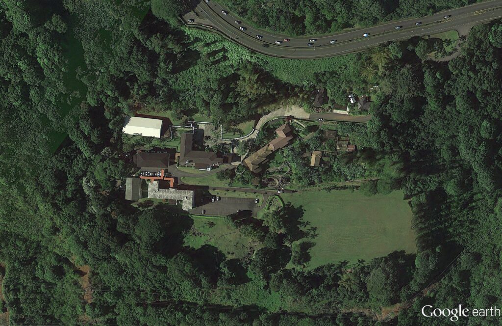
In 1927, Harold and his wife Alice Hedemann Castle built a home for themselves that overlooked much of their land holdings.  It was just below the hairpin turn, below the Pali.

They called the home Palikū (Lit., vertical cliff.)

Architect Bertram Grosvenor Goodhue designed it (Goodhue’s other work included Los Angeles Central Public Library, the Nebraska State Capitol and Saint Thomas Church, New York City;) there were 27 rooms with ornamental ironwork, redwood beams, plumbing and electricity – one of the first buildings on the windward side of the island to have those amenities. (Brennan, Honolulu Advertiser)

In 1946, the Castles sold the 22-acre Palikū to the Catholic Church for the Saint Stephen Seminary (the seminary closed in 1970; it’s now the St. Stephen’s Diocesan Center (the driveway is makai, just below the scenic lookout at the hairpin turn.))

St. Stephen’s Seminary was shut down for a time after a mysterious occurrence in October 1946.

Some suggest the seminary was haunted; when one night there were methodical clicking and tapping sounds; invisible pressure on a person in bed; dishes, pots and pans strewn all over – they suggest it was “diabolical obsession.”  Later, “I understand there was some kind of a blessing done,” said Bishop Joseph Ferrario, the retired bishop of Honolulu. (honoluluadvertiser)

After the seminary’s ultimate closure, the facility was transformed into a diocesan center housing various offices of the diocesan curia (a diocesan center (chancery) is the branch of administration which handles all written documents used in the official government of a Roman Catholic diocese.)

The former Castle home also serves as the residence of the Bishop of Honolulu, Clarence Richard Silva, popularly known as Larry Silva (born August 6, 1949), bishop of the Roman Catholic Church. He is the fifth Bishop of Honolulu, appointed by Pope Benedict XVI on May 17, 2005.

In 1962, Castle founded the Harold KL Castle Foundation. On his death in 1967, he bequeathed a sizeable portion of his real estate assets to the Foundation.

Throughout his life, Castle donated land for churches of all different denominations because he felt that churches would bring congregations, congregations would bring stability, and that would benefit the community that was growing around them.

Mr. Castle also donated land and money to Hawaii Loa College, Castle Hospital, ʻIolani School, Castle High School, Kainalu Elementary School and the Mōkapu peninsula land, which would become the Kāneʻohe Marine Corps Base.

His foundation has annually provided millions of dollars in support to worthy causes, a good chunk of it going to the windward side of Oʻahu.

© 2022 Hoʻokuleana LLC

Filed Under: Buildings, Prominent People, Economy Tagged With: Windward, Mokapu, Paliku, Hawaii, Castle and Cooke, Oahu, Kaneohe, Kailua, Kainalu, Harold Castle, Koolaupoko, Kaneohe Ranch

Images of Old Hawaiʻi

People, places, and events in Hawaiʻi’s past come alive through text and media in “Images of Old Hawaiʻi.” These posts are informal historic summaries presented for personal, non-commercial, and educational purposes.

Info@Hookuleana.com

Connect with Us

  • Email
  • Facebook
  • LinkedIn
  • Twitter
  • YouTube

Recent Posts

  • Peter Cushman Jones
  • Kīlauea Military Camp
  • Hopu
  • Atooi
  • Okino Hotel
  • John Howard Midkiff Sr
  • Kalihi

Categories

  • Hawaiian Traditions
  • Military
  • Place Names
  • Prominent People
  • Schools
  • Sailing, Shipping & Shipwrecks
  • Economy
  • Voyage of the Thaddeus
  • Mayflower Summaries
  • American Revolution
  • General
  • Ali'i / Chiefs / Governance
  • Buildings
  • Missionaries / Churches / Religious Buildings

Tags

Albatross Al Capone Ane Keohokalole Archibald Campbell Bernice Pauahi Bishop Charles Reed Bishop Downtown Honolulu Eruption Founder's Day George Patton Great Wall of Kuakini Green Sea Turtle Hawaii Hawaii Island Hermes Hilo Holoikauaua Honolulu Isaac Davis James Robinson Kamae Kamaeokalani Kamanawa Kameeiamoku Kamehameha Schools Lalani Village Lava Flow Lelia Byrd Liliuokalani Mao Math Mauna Loa Midway Monk Seal Northwestern Hawaiian Islands Oahu Papahanaumokuakea Marine National Monument Pearl Pualani Mossman Queen Liliuokalani Thomas Jaggar Volcano Waikiki Wake Wisdom

Hoʻokuleana LLC

Hoʻokuleana LLC is a Planning and Consulting firm assisting property owners with Land Use Planning efforts, including Environmental Review, Entitlement Process, Permitting, Community Outreach, etc. We are uniquely positioned to assist you in a variety of needs.

Info@Hookuleana.com

Copyright © 2012-2024 Peter T Young, Hoʻokuleana LLC


Loading Comments...