Images of Old Hawaiʻi

  • Home
  • About
  • Categories
    • Ali’i / Chiefs / Governance
    • American Protestant Mission
    • Buildings
    • Collections
    • Economy
    • Missionaries / Churches / Religious Buildings
    • General
    • Hawaiian Traditions
    • Other Summaries
    • Mayflower Summaries
    • Mayflower Full Summaries
    • Military
    • Place Names
    • Prominent People
    • Schools
    • Sailing, Shipping & Shipwrecks
    • Voyage of the Thaddeus
  • Collections
  • Contact
  • Follow

December 29, 2023 by Peter T Young Leave a Comment

Kūpikipikiʻō

An eruption from a vent southeast of Lēʻahi (Diamond Head) poured dense lava into the sea to build a headland. The Hawaiians called it Kūpikipikiʻō (rough (sea) or agitated (wind or storm)) because of its turbulent waters.

The waves attack the headland directly, but the shore on either side of it is protected by a reef. (MacDonald)  The black lava that formed there prompted its modern name, Black Point.

When Kamehameha and his warriors made their attack in Oʻahu in 1795, they landed from Waikīkī to Maunalua – right in this area.  More than 100-years later, around 1901, one of Black Point’s first houses was built by developer Fred Harrison.  (Star-Bulletin)

In January 1905, President Teddy Roosevelt instructed Secretary of War William H. Taft to convene the National Coast Defense Board (Taft Board) “to consider and report upon the coast defenses of the United States and the insular possessions (including Hawai‘i.)”

Based on recommendation of the Secretary of War, on January 18, 1906, President Teddy Roosevelt signed Executive Order 395-A, setting aside public lands at Kūpikipikiʻo Point for military purposes.

“From Kūpikipikiʻo Point to Waipiʻo Peninsula the line of defense is to be strengthened with field fortifications, batteries and searchlights, and as soon as the money becomes available the dirt will begin to fly and the concrete to take form, under the supervision of the army engineers.”  (Star-Bulletin, February 4, 1914)

Fort Ruger Military Reservation was established at Lēʻahi in 1906.  The Reservation was named in honor of Major General Thomas H Ruger, who served from 1871 to 1876 as the superintendent of the United States Military Academy at West Point.

The fort included Battery Harlow (1910-1943); Battery Birkhimer (1916-1943); Battery Granger Adams (1935-1946); Battery Dodge (1915-1925); Battery Mills (1916-1925); Battery 407 (1944); Battery Hulings (1915-1925) and Battery Ruger (1937-1943.)

Battery Mills was built on a 3-acre tract in the Kūpikipikiʻo Point Reservation.   Battery Mills was not technically part of Fort Ruger, but was administered by it.  The battery was armed with two 5-inch Seacoast guns.

There was a reinforced magazine for munitions, a plotting room/command bunker and an underground power room which had a generator. Those guns were later eliminated from the Army’s inventory, so the Battery was decommissioned.

Battery Granger Adams (1933 and 1935) replaced Battery Mills and consisted of two 8-inch railway guns on either side of a protected powder and shell magazine, along with a Commander’s Station and power room (it was felt that there was still a need for a gun battery at that location – it was later decommissioned in 1946.)

The conclusion of World War II and the advent of nuclear and missile warfare made the coastal batteries obsolete. Thus, in December 1955 the majority of the land was turned over to the State of Hawai‘i.

Nearby Kaʻalāwai Beach lies at the base of Diamond Head’s eastern slope, between Kuilei Cliff Beach Park (“lei stringing”) to the west and Black Point to the east.

Kaʻalāwai (“the watery rock”) is a narrow, white-sand beach with a shallow reef offshore, which makes for generally poor swimming conditions. There are only a few scattered pockets of sand on the nearshore ocean bottom.

Freshwater bubbles up between the rocks of the reef. The beach is mainly used by surfers, who paddle out to the surf spot called Brown’s, which is located just behind the reef.

An old Beach Road fronted the Kaʻalāwai oceanfront properties.  In 1959, owners of the abutting properties claimed the ownership of the old beach road; after a series of lawsuits, many of them obtained declaratory judgments which allowed them to buy the road right-of-way.

At the east end of the beach near Black Point is Shangri-La, a mansion turned museum, built by Doris Duke, the daughter of James Buchanan Duke, the founder of the American Tobacco Company, and her husband, James Cromwell, in 1937.

Upon her father’s death, Doris Duke received large bequests from her father’s will when she turned 21, 25, and 30; she was sometimes referred to as the “world’s richest girl.”

In the late 1930s, Doris Duke built her Honolulu home, Shangri La, on 5-acres overlooking the Pacific Ocean and Diamond Head.  Shangri La incorporates architectural features from the Islamic world and houses Duke’s extensive collection of Islamic art, which she assembled for nearly 60 years.

Today, Shangri La is open for guided, small group tours and educational programs. In partnership with the Doris Duke Foundation for Islamic Art – which owns and supports Shangri La – the Honolulu Museum of Art serves as the orientation center for Shangri La tours.

To get to Kaʻalāwai Beach and Cromwell’s Cove take Diamond Head Road east and turn right on Kulamanu Street and park curbside.  The beach access is at the end of Kulamanu Place.

A later building boom by the wealthy turned Black Point into one of the world’s most exclusive and expensive community.

© 2023 Hoʻokuleana LLC

Filed Under: General, Buildings, Place Names, Economy Tagged With: Kaalawai, Kupikipikio, Fort Ruger, Black Point, Hawaii, Oahu, Leahi, Diamond Head, Shangri La, Doris Duke

April 1, 2022 by Peter T Young 1 Comment

Diamond Head Charlie

“Ste-e-e-mer off Koko Head!”  (PCA, 1906)

“Before the telephone was invented, and long before the system was in use in Honolulu, we had the lookout station on Telegraph Hill, which by means of a semaphore arrangement communicated with a station on the building (downtown.)”

“Every merchant was supplied with the code, and whenever a schooner, a steamer, a mail packet, or a man of war, was sighted, the heart of the town knew it immediately.”  (Hawaiian Star, February 10, 1899)

Pu‘u O Kaimukī (aka “Kaimukī Hill”) was used as a sighting and signal station (using semaphore technology,) giving it the name “telegraph hill.”   It had broad view over the Pacific and line-of-sight to downtown Honolulu.  Back then, they used this vantage point to spot ships coming in, and then conveyed the news to Honolulu.

This is where John Charles Pedersen was first stationed.  Petersen was appointed lookout … by the then Minister of the Interior, Samuel G Wilder. The station was located at the top of Kaimuki Hill. (Evening Bulletin, September 27, 1907)

Semaphore towers used arms and blades/paddles to convey messages; messages were conveyed/decoded based on the fixed positions of these arms.  Reportedly, in 1857, a semaphore mechanism on Puʻu O Kaimukī, with large moveable arms, was attached to the top of a sixty-foot pole and used to signal to Honolulu.

The official receiving station from Kaimukī was on Merchant Street, but some have suggested other receiving stations at Kaʻahumanu Street and the foot of Nuʻuanu.

“When the telephone system got into working order the lookout station was moved to a position on Diamond Head which gave a view further along the channel, because it was no longer necessary for the station to be in full view of the city.” (Hawaiian Star, February 10, 1899)

Diamond Head was connected by telephone with the book store of Whitney & Robertson conducted in Honolulu Hale.  (Evening Bulletin, September 27, 1907)

Petersen’s regular weather reports (telephoned every evening promptly at 10 o’clock,) “Diamond Head – 10 pm – weather, hazy; wind, fresh, NE,” or calls with a ship sighting, “Ste-e-e-mer off Koko Head!” “gladdens the hearts of thousands of people every week.”  (Pacific Commercial Advertiser, January 29, 1906)

Following the call, HECO’s whistle would scream three long blasts, loud enough for all Honolulu to hear. This meant the ship would arrive in two hours, and people rushed to the harbor.

“All hands, including government officials of many grades and various departments, agents’ representatives, post office clerks, hotel and newspaper men, waterfronters, hackmen, messengers, shipping men, storekeepers, the large army of people “expecting friends,” and frequently Captain Berger and the Hawaiian Band, make haste to get down to the dock to ‘see the steamer come in.’” (Pacific Commercial Advertiser, January 29, 1906)

“For many years all Honolulu has depended on one man to announce the sighting of mail and freight steamers as well as the fleet of ‘windjammers.’  … ‘John Chas. Peterson, Keeper Diamond Head Signal Station,’ as he is designated in the directory.”  (Pacific Commercial Advertiser, January 29, 1906)

He was better known as Diamond Head Charlie.

Petersen was born in Gothenburg, Sweden. He came to the Islands eighteen years ago from San Francisco in the old schooner Lizzie Wight.   He left for a short while, returned and married a Hawaiian who died four months after her child was born. “The pledge of their union still lives to cheer the father’s heart.”

“His house is built on a rough slope of Diamond Head, facing the sea and from its position the faithful lookout commands an almost unlimited view of the broad Pacific. His business is to watch for incoming vessels and report them. … He watches with unfailing zeal, and it is very seldom that a vessel ever escapes his sharp eyes.”  (Pacific Commercial Advertiser, December 19, 1894)

“The great landmark on which he passes his time is well known to tourists and others, and it is eagerly watched for from the decks of incoming steamers. With the aid of glasses passengers can detect a small cottage, painted white, which is built on the side of the bleak extinct volcano.”

“Their home consists of bedrooms, a tiny bit of a pantry, and an observation room, from which Peterson scans the sea. On one side a large water tank stands, encased in wood; they must store the rain water or else go as far as James Campbell’s for the fluid.”

“In front of the cottage stands a flagpole eighty feet high, which is used for signaling. In a locker “Charlie” has a full complement of flags, and is proud of his belonging.”

“A large telescope stands in the observation room, which aids the eye to see a distance of at least thirty miles.  It is a powerful glass and when a vessel is eight miles away she does not appear to be more than 1000 yards distant. This telescope was presented to the lookout by Wm. G. Irwin and other merchants about town.”

“Peterson is on duty about seventeen hours every day, and divides his time between watching for vessels and cooking his meals. He has no servants, and of course must prepare his own food, which is done under great difficulties at times, as he has no kitchen.”

“He comes to town but once a month for his pay. While he is absent from his post, which is taken for the time being by a native, he usually purchases enough supplies to last him a month. His salary at present is $75 a month. He started in sixteen years ago at $50, and after a year’s time the sum was increased to $60.  He worked for twelve years for the last mentioned sum.”  (Pacific Commercial Advertiser, December 19, 1894)

“His glory began to grow dim when the lighthouse was erected at the Head and a keeper came to divide honors with him. Though he has constantly been an important factor to the business community and reported the ships appearing off the port, he became less a household word after the installation of the trans-Pacific cable.”    (Evening Bulletin, September 27, 1907)

“Each year since 1895 General Soper has made a Christmas collection for Charlie among the business men of the town. The largest sum was $440 collected in 1902. Charlie was a faithful man and the news of his death (September 27, 1907) caused widespread expressions of regret throughout the town.  (Evening Bulletin, September 27, 1907)

“For several weeks past Peterson was in the hospital and little hope was held for his recovery.  Close on the allotted three score years and ten, he now sighted that mysterious bark whose captain is called Death.”  (Pacific Commercial Advertiser, September 28, 1907)

© 2022 Hoʻokuleana LLC

Filed Under: Prominent People, Economy Tagged With: Hawaii, Oahu, Kaimuki, Leahi, Diamond Head, Diamond Head Lighthouse, Diamond Head Charlie, John Charles Pedersen

February 4, 2022 by Peter T Young Leave a Comment

Built in About an Hour

The Hawaiian Islands were formed as the Pacific Plate moved westward over a geologic hot spot.  Oʻahu is dominated by two large shield volcanoes, Waiʻanae and Koʻolau that range in age from two to four-million years old.

The younger volcanic craters are all less than 500,000 years old. They formed after Oʻahu had moved well off the hot spot and the main shield volcanoes had gone dormant for at least two-million years.

Scientists say Lēʻahi (Diamond Head) (one of these later eruptions) is a tuff cone, formed by hydromagmatic activity.  Tuff is a volcanic rock made up of a mixture of volcanic rock and mineral fragments. Wherever there are explosive volcanic eruptions you can expect to find tuff.  (SOEST)

A hundred years ago, Hawaiʻi missionary Reverend Sereno Bishop noted Diamond Head was made in less than an hour’s time and is “composed not of lava, like the main mountain mass inland, but of this soft brown rock called tuff.” (Bishop, Commercial Advertiser, July 15, 1901)

Others noted, “the duration of eruption of Diamond Head was of the order of five hours. The eruption may have been intermittent with interruptions sufficient to extend the whole period of activity to as much as five days, but probably not more.”    (Wentworth, Bishop Museum, 1926)

“Volcanic eruptions may be distinguished into two classes, the effusive and the explosive. In the former the molten rock is poured out and covers the mountain slopes with great floods.”

“If you look up at the sides of yonder ravines (on the Koʻolau mountains,) which the rainstorms of many hundred thousands of years have worn out of the original dome-shaped mountain, you will see the back edges of the ancient lava streams lying in layers.”

“The tuff cones are entirely different, and are produced by very brief and sudden explosive eruptions.  The tuff was violently shot high aloft into the air in the form of superheated mud. This hot mud cooled and thickened by the expansion of its water and its partial escape as steam before reaching the ground.”

“It hardened and cemented as it fell, though still liquid enough to form in thin layers or laminations as we see it lying around us at the base of the hill. … The tuff-fountain escaping from its confinement, at once expanded and spread out like a vast tree.”

“Here at Diamond Head, which is one mile in diameter, the bulk of the mud spread out half a mile in all directions before ending its fall. Thus a very exact circular ring was piled up of one mile in diameter. There was, however, another influence, that of a violent easterly-wind which deflected the entire fountain westward”.

“The wind also acted with especial force upon the highest part of the fountain, flinging and piling it up on the western side of the crater in a lofty cone. A large part of that cone has been weathered away by the impact of rainstorms upon the soft rock; but it still stands in a peak some 200 feet higher than the main run.”

“The vent or point of issue of the tuff-fountain must have been at the lowest point of the interior, where lies the present pond of water.”  (Bishop, Commercial Advertiser, July 15, 1901)  (The same series of eruptions produced Punchbowl and Koko Head Crater.)

Somewhat more than half of the craters of southeast Oahu are arranged in linear groups, those dominated by the craters Tantalus, Diamond Head, and Koko Crater.  In the Diamond Head group is the main Diamond Head vent, Kaimuki crater and Mauʻumae crater.

(A cinder cone is a volcanic cone built almost entirely of loose volcanic fragments called cinders or pumice that accumulate around and downwind from a vent.)

(Cinders are glassy and contain numerous gas bubbles “frozen” into place as magma exploded into the air and then cooled quickly.)  (USGS)

© 2022 Hoʻokuleana LLC


Filed Under: General, Place Names Tagged With: Hawaii, Oahu, Koolau, Sereno Bishop, Leahi, Diamond Head

November 6, 2021 by Peter T Young 1 Comment

Portlock

Recent work that I have been involved with in the Portlock area on O‘ahu, reminded me of the namesake for the place, explorer and fur trader Nathaniel Portlock.

Nathaniel Portlock was born in about 1748 in Norfolk, Virginia, where his grandfather had emigrated, probably from the English south-west, around 1685. Nathaniel’s father died in 1752, leaving his wife Rebecca (formerly Ballard, who had previously been a widow with a daughter from a previous marriage).

Nathaniel’s father’s will left his property, and stay and board, to “my Daughter in Law Nancey Ballard a Negro … said children [Paul and Nathaniel] [and] their mother”.

After Portlock’s father’s death, his mother Rebecca quickly remarried a third time to a Richard Scott, who became guardian to her three surviving Portlock children and had others with her.

At about the age of 24, Nathaniel Portlock entered the British Royal Navy and was one of the loyal colonists of America, known as the “American Loyalists;” he later left that country on the close of the War of Independence.

(It is not clear what relationship a certain John Portlock had with Nathaniel; but John was born in 1765 in Shenandoah Co., Virginia and in 1781 volunteered to serve in the Virginia Regiment and fought and was “slightly wounded’ in the American Revolutionary War. It is an interesting situation if they are related.)

On March 30, 1776, he served as master’s mate on Captain James Cook’s third Pacific voyage aboard the Discovery. Portlock was transferred to the Resolution, also on the expedition, in August 1779.

Cook’s third and final voyage (1776-1779) of discovery was an attempt to locate a North-West Passage, an ice-free sea route which linked the Atlantic to the Pacific Ocean. Cook commanded the Resolution while Charles Clerke commanded Discovery. (State Library, New South Wales)

“Cook had chosen his subordinates well or had been lucky. The officers of the third voyage were a remarkably intelligent group of men.” (Captain Cook Society)

“All the great remaining voyages of the eighteenth century drew on Cook’s officers. Bligh, Portlock, Vancouver, Colnett, Riou, and Hergest all got their commands and served with great distinction. These men then passed on their skills to a second generation of men such as Flinders and Broughton.” (Mackay, Captain Cook Society)

Nathaniel Portlock and George Dixon, observed the commercial benefits that the development of the fur trade in the region could bring. In 1785, a group of London merchants formed the “King George’s Sound Co” (also known as Richard Cadman Etches and Company).

They proposed to carrying on the fur trade from the western coast of America to China, bringing home cargoes of tea from Canton for the East India Company. They bought two boats; Portlock and Dixon were selected to sail them (Dixon also previously sailed with Cook to Hawai‘i) and they set off on an expedition to North America to establish a foothold for fur trappers.

Portlock commanded the 1785-1788 expedition from the ship King George, while Dixon captained the Queen Charlotte. The purpose of the expedition was to investigate the potential of the Alaskan fur trade and to resume Cook’s search for a Northwest Passage through the continent.

The pair left England on August 29, 1785, and took nearly a year to reach Alaska, rounding Cape Horn and touching at Hawaiʻi on the way, first arriving off the coast of Kaʻū, May 24, 1786.

These were the first English ships to reach Hawai‘i following Captain Cook’s first arrival there in 1778. During the course of their 3-year expedition, they made three trips to Hawaiʻi.

A favorite anchorage on Oʻahu for Portlock was at Maunalua Bay (which Portlock named King George’s Bay). He named the Waikiki area (Diamond Head to Honolulu) Queen Charlotte’s Bay.

The East point of the Maunalua Bay (Koko Head) Portlock named Point Dick, “in honour of Sir John Dick, the first patron of this voyage,”) and the West point (Diamond Head) that Portlock named “Point Rose, after George Rose Esq. secretary of the treasury, the second worthy patron of our undertaking.” (Portlock)

Portlock also mentioned what is probably Kuapā Pond that he described as, “a little salt water river that has a communication with King George’s Bay.”

Portlock wrote about the early challenges of getting fresh drinking water in the region as they “found that we could not water at this place without an infinite deal of trouble …”

“… besides the danger of losing our casks, getting the boats dashed to pieces against the rocks, and the inconvenience of carrying our casks so far amongst a multitude of Indians, which would make it necessary to have an armed force on shore.”

“Towards evening the surgeon returned on board with the convalescents, and informed me, that the inhabitants had behaved in a very quiet inoffensive manner, though they were rather incommoded by the multitudes which curiosity brought about them.”

“By this time all our water from the ground tier was got to hand, and the cables coiled down. The inhabitants now brought us water in such plenty, that by noon on the 4th all our empty casks were filled”.

He noted, “As good water in any quantity may be procured at this island with the greatest facility for small nails and buttons, it undoubtedly must be the safest and most expeditious method any person can adopt who may chance to touch here, to barter for their water in the manner we did.” (Portlock)

“No chiefs of consequence paid us a visit as yet: the inferior chiefs indeed came on board without any scruple, and some of them slept with us every night. Amongst rest I had a daily visit from an old priest, who always brought by way of present, a small pig, and a branch of the cocoa-nut·tree.” (Portlock)

Maunalua was thought to be well-populated in ancient times. Maunalua was known for its offshore fishing resources, a large fishpond, and sweet potato cultivation. Taro was farmed in wet areas, sweet potato was grown in the drier regions and a series of fishing villages lined the coast. (McElroy) Part of that area now carries the Portlock name.

© 2021 Hoʻokuleana LLC

Filed Under: Sailing, Shipping & Shipwrecks, Economy, Prominent People Tagged With: Maunalua, Hawaii, Kamehameha Schools, Oahu, Captain Cook, Leahi, Diamond Head, Maunalua Bay, Portlock, Nathaniel Portlock

November 15, 2019 by Peter T Young Leave a Comment

Papaʻenaʻena Heiau

Hawaiʻi’s iconic landmark, Lēʻahi (Diamond Head) overlooks Waikīkī. Papaʻenaʻena heiau once stood on its western slope, overlooking the Waikīkī coastline. It was referred to by some early writers as “Lēʻahi heiau.”

“It consisted of a mana (supernatural or divine power) house approximately 50 feet long; an oven house (hale umu); a drum house; a waiea or spiritual house; an anuʻu or tower; a lele (altar) and twelve large images. The heiau was bordered by a rectangular wooden fence approximately six to eight feet tall with an eight-foot wide base, which narrowed to three feet at its apex.” (Ireland)

It is likely that the heiau was built in 1783 by Kahekili, the mōʻī (ruler) of Maui, as part of a victory celebration following Kahekili conquest of Oʻahu.

Surfing was one of the principal attractions for Waikīkī to both the chiefs and commoners who resided there. “Here at the ‘surfing heiau’ of Papaʻenaʻena, a terraced structure … is where surfers came to offer their sacrifices in order to obtain mana and knowledge of the surf.” (Kanahele)

When surf was ‘up,’ Kahuna at Papaʻenaʻena heiau reportedly flew a kite at the heiau as a signal to the people of the wave conditions. (Kanahele)

An ancient chant tells of Papaʻenaʻena and surfing:

There at Kalahuewehe is the big surf created by Papaʻenaʻena.
Arise, of ye surf of Kalahuewehe, arise! …
The kahuna of Papaʻenaʻena flies his moon kite
To proclaim the suitability of the sea for surfing.
The eager lookout on yonder highland
Anxiously scans the skies for this signal,
And relays the good news by runners;
Farmers, woodsmen, bird catchers all,
Leave their tasks and fetching their surf boards
Hurry to the beach at Waikiki.
Soon the sea is filled with natives
Sporting in the billowy surf;
Trick riding, zigging and zagging, amidst the foam,
Shouting words of defiance against the angry surf
To topple the rider if it can …. (Kanahele)

Papaʻenaʻena heiau was also a luakini heiau; human sacrifices were made at the terraced stone structure. The heiau was probably used for sacrificial or sacred purposes for 35 years.

Some historians believe that when Kamehameha I conquered ‘Oahu in 1795 at the Battle of Nuʻuanu, Kamehameha I used Papaʻenaʻena heiau to offer a sacrifice of his slain rival, Kalanikūpule, to his war god Kūkaʻilimoku.

After Kamehameha’s troops were overcome with dysentery in 1804, that stopped his attempt to conquer Kauaʻi, Kamehameha repaired Papaʻenaʻena heiau and offered in sacrifice 400 pigs, numerous coconuts and bananas and three kapu violators.

The heiau was also used for one (possibly its last) sacrifice. Kanihonui was killed and placed on the Papaʻenaʻena alter.

Kamehameha learned that Queen Kaʻahumanu had an affair with Kanihonui. He was a handsome 19-year old. Reportedly, Kaʻahumanu had seduced the boy while she was intoxicated; in addition, the boy was the son of Kamehameha’s half-sister – and, Kamehameha and Kaʻahumanu raised him.
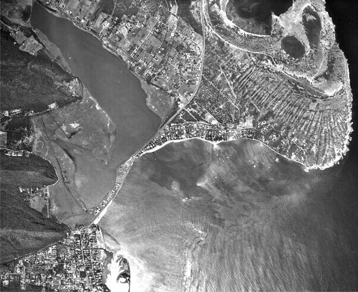
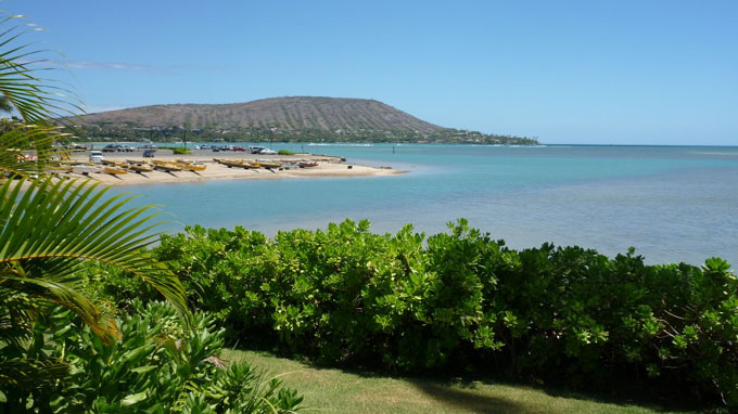
George W. Bates, in 1854, describes a heiau at the foot of Lēʻahi (believed to be Papaʻenaʻena) as: “Just beyond Waikiki stand the remains of an ancient heiau, or pagan temple. It is a huge structure, nearly quadrangular, and is composed merely of a heavy wall of loose lava stones, resembling the sort of inclosure commonly called a ‘cattlepen.’”

“This heiau was placed at the very foot of Diamond crater, and can be seen at some distance from the sea. Its dimensions externally are 130 by 70 feet. The walls I found to be from six to eight feet high, eight feet thick at the base, and four at the top.”

“On climbing the broken wall near the ocean, and by carefully looking over the interior, I discovered the remains of three altars located at the western extremity, and closely resembling parallelograms. I searched for the remains of human victims once immolated on these altars, but found none; for they had returned to their primitive dust, or been carried away by curious visitors.”

Later (at about 1856,) Queen Emma ordered her workers to take rocks from Papaʻenaʻena heiau to build a stone wall around her property at Waikīkī.

During the Māhele the site was transferred to the future King Lunalilo. After the king’s death, this site was sold to James Campbell, in 1883. Later, Walter F. Dillingham bought the land from Campbell.

With the help of famed Chicago architect, David Adler, the Dillinghams built a home similar to the Villa La Pietra they admired in Tuscany while on their honeymoon – they named their new home La Pietra – meaning The Gem or The Rock.

After Walter’s death, La Pietra was sold to Hawaii School for Girls, who relocated their school there (1969.) The former Papaʻenaʻena heiau site is now the home for La Pietra – Hawaii School for Girls, an independent, college preparatory school for girls, grades 6 through 12.

When Papaʻenaʻena heiau stood on Diamond Head, it overlooked what is today First Break, the beginning of Kalahuewehe, a surfing spot famous for hundreds of years.

Follow Peter T Young on Facebook 

Follow Peter T Young on Google+ 

Follow Peter T Young on LinkedIn  

Follow Peter T Young on Blogger

© 2019 Hoʻokuleana LLC

Reconstruction-illustration-Papaenaena_Heiau-(NPS)
Waikiki-Bishop-Reg944 (1882)-noting_Papaenaena_heiau
Waikiki-Diamond_Head-USGS-UH_Manoa-2420-1952-noting_La_Pietra-Papaenaena
Waikiki-Kaneloa-(Before Kapiolani_Park)-Lyons-Reg0306 (1876) (portion)-noting_Papaenaena

Filed Under: Hawaiian Traditions, Place Names Tagged With: La Pietra, Papaenaena Heiau, Hawaii, Waikiki, Leahi, Diamond Head

  • 1
  • 2
  • 3
  • Next Page »

Images of Old Hawaiʻi

People, places, and events in Hawaiʻi’s past come alive through text and media in “Images of Old Hawaiʻi.” These posts are informal historic summaries presented for personal, non-commercial, and educational purposes.

Info@Hookuleana.com

Connect with Us

  • Email
  • Facebook
  • LinkedIn
  • Twitter
  • YouTube

Recent Posts

  • Okino Hotel
  • John Howard Midkiff Sr
  • Kalihi
  • Hawaii and Arkansas
  • Barefoot Football
  • Arthur Akinaka
  • Food Administration

Categories

  • Economy
  • Voyage of the Thaddeus
  • Mayflower Summaries
  • American Revolution
  • General
  • Ali'i / Chiefs / Governance
  • Buildings
  • Missionaries / Churches / Religious Buildings
  • Hawaiian Traditions
  • Military
  • Place Names
  • Prominent People
  • Schools
  • Sailing, Shipping & Shipwrecks

Tags

Albatross Al Capone Ane Keohokalole Archibald Campbell Bernice Pauahi Bishop Charles Reed Bishop Downtown Honolulu Eruption Founder's Day George Patton Great Wall of Kuakini Green Sea Turtle Hawaii Hawaii Island Hermes Hilo Holoikauaua Honolulu Isaac Davis James Robinson Kamae Kamaeokalani Kamanawa Kameeiamoku Kamehameha Schools Lalani Village Lava Flow Lelia Byrd Liliuokalani Mao Math Mauna Loa Midway Monk Seal Northwestern Hawaiian Islands Oahu Papahanaumokuakea Marine National Monument Pearl Pualani Mossman Queen Liliuokalani Thomas Jaggar Volcano Waikiki Wake Wisdom

Hoʻokuleana LLC

Hoʻokuleana LLC is a Planning and Consulting firm assisting property owners with Land Use Planning efforts, including Environmental Review, Entitlement Process, Permitting, Community Outreach, etc. We are uniquely positioned to assist you in a variety of needs.

Info@Hookuleana.com

Copyright © 2012-2024 Peter T Young, Hoʻokuleana LLC


Loading Comments...