Images of Old Hawaiʻi

  • Home
  • About
  • Categories
    • Ali’i / Chiefs / Governance
    • American Protestant Mission
    • Buildings
    • Collections
    • Economy
    • Missionaries / Churches / Religious Buildings
    • General
    • Hawaiian Traditions
    • Other Summaries
    • Mayflower Summaries
    • Mayflower Full Summaries
    • Military
    • Place Names
    • Prominent People
    • Schools
    • Sailing, Shipping & Shipwrecks
    • Voyage of the Thaddeus
  • Collections
  • Contact
  • Follow

December 27, 2022 by Peter T Young Leave a Comment

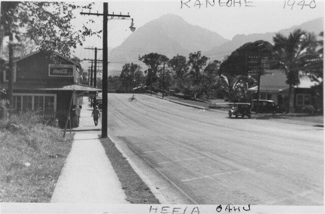
Heʻeia

The nine ahupuaʻa of Kāneʻohe Bay, beginning at the boundary between Koʻolauloa and Koʻolaupoko Districts (west) and moving eastward, are Kualoa, Hakipuʻu, Waikāne, Waiāhole, Kaʻalaea, Waiheʻe, Kahaluʻu, Heʻeia and Kāneʻohe.

The ahupuaʻa of Heʻeia and Kāneʻohe also included portions of Mōkapu Peninsula (Heʻeia runs from the mountains to the sea, but also crosses over a portion of the water in Kāneʻohe Bay and includes a portion of a Mōkapu peninsula across the Bay.)  Heʻeia also includes Moku-o-Loʻe (Coconut Island,) Kahaluʻu includes Kapapa Island and Kualoa includes Mokoliʻi.

The name of the land of Heʻeia is traditionally associated with Heʻeia, the handsome foster son of the goddess Haumea and grandson of the demigod ʻOlopana, who was an uncle of Kamapuaʻa.

Heʻeia was named in commemoration of a tsunami-type wave that washed Haumea and others into the sea – a great tidal wave that “washed (he‘e ‘ia) … out to sea and back” (Lit., surfed, or washed (out to sea,) or swept away.)

They swam until they were exhausted and were finally washed ashore at Kapapa Island in Kāneʻohe Bay. It was the handsome Heʻeia who fell in love with Kaohelo, a younger sister of Pele and Hiʻiaka, whom he met in Koʻolau, Oʻahu.  (Devaney)

In ancient Hawai‘i, fishponds were an integral part of the ahupua‘a food source.  Hawaiians built rock-walled enclosures in near shore waters to raise fish for their communities and families.  Loko iʻa (fishpond) were used for fattening and storing of fish for food and also as a source for kapu (forbidden) fish.  Walled, brackish-water fishponds were usually constructed on the reef along the shore and one or more mākāhā (sluice gate.)

Heʻeia Fishpond’s wall was one of the longest, extending nearly a mile.  As a large pond, it is subject to considerable evaporation, increasing salinity in the pond; as such, fresh water is added.  Heʻeia is somewhat unique in that it has mākāhā gates on the mauka wall to control the flow of fresh water.

Kalo (taro) was a main staple in the diet of nearly all Hawaiians prior to European contact and was extensively cultivated.  As early as 1789, Portlock described this area:

“… the bay all around has a very beautiful appearance, the low land and valleys being in high state of cultivation, and crowded with plantations of taro, sweet potatoes, sugar-cane, etc. interspersed with a great number of coconut trees ….”

The region had a considerable amount of land cultivated in taro up through the early-1800s.  “Southeastward along the windward coast, beginning with Waikāne and continuing through Waiāhole, Kaʻalaea, Kahaluʻu, Heʻeia and Kāne’ohe, were broad valley bottoms and flatlands between the mountains and the sea which, taken all together, represent the most extensive wet-taro area on Oʻahu.” (Handy, Devaney)

The rains that sweep through here have been memorialized in poetry and song.  A traditional mele honoring Kaumuali‘i suggests “the sound of heavy rain drops on dry leaves, or dry thatching of the pandanus leaf, … of the rain accompanying the koʻolau wind, which calms the troubled waters”.

This “heavy-sounding rain” of the Koʻolau has been transformed into a poetical saying, “Ka ua kani koʻo o Heʻeia, The rain of Heʻeia that sounds like the tapping of walking canes”.  (Fornander)

During the early historic times, many of the ruling chiefs favored this area as their place of residence. Kahahana the ruler of Oʻahu sometimes resided there. Kahekili after defeating Kahahana lived in Kailua, Kāneʻohe and Heʻeia.

The Sacred Hearts Father’s College of Ahuimanu was founded by the Catholic mission at Ahuimanu, Heʻeia in 1846.  “Outside the city, at Ahuimanu, Maigret has now a country retreat that he refers to by the Hawaiian word māla.  It is a combination garden, orchard and kitchen garden. …”

“The venerable bishop has built his own vineyard and planted his own orchard … His retreat in the mountain, his “garden in the air” as he terms it, is a pleasant and profitable sight … When the pressure of events allows it, Maigret takes refuge there.” (Charlot)

One of its students, Damien (born as Jozef de Veuster,) arrived in Hawaiʻi on March 9, 1864, at the time a 24-year-old choirboy.  Determined to become a priest, he had the remainder of the schooling at the College of Ahuimanu.  Bishop Maigret ordained Father Damien at the Cathedral of Our Lady of Peace in 1864 and later assigned him to Molokaʻi.  In 2009, Father Damien was canonized by Pope Benedict XVI.

The earliest of the modern large commercial agricultural ventures started with the cultivation of sugar cane in Kualoa in the 1860s. By 1880, three more sugar companies had emerged in Kahaluʻu, Heʻeia and Kāne’ohe. Heʻeia Sugar Company (also called Heʻeia Agricultural Co. Ltd) operated from 1878 to 1903.

In 1880, the region reported 7,000-acres available for cultivation; in 1883 a railroad was installed at Heʻeia, and by the summer of that year it was noted that the railroad had allowed a much greater amount of land to be harvested, even allowing cane from Kāneʻohe to be ground at Heʻeia; however, the commercial cultivation of sugar cane was short-lived.  (Devaney)

Rice cultivation did not occur in earnest until the decline of sugar, and in 1880 the first Chinese rice company started in the nearby Waineʻe area. Abandoned systems of loʻi kalo were modified into rice paddies. The Kāneʻohe Rice Mill was built around 1892-1893 in nearby Waikalua.

Another commercial crop, pineapple, was also grown here, starting around 1910.  By 1911, Libby, McNeill & Libby gained control of land here and built the first large-scale cannery with an annual capacity of 250,000-cans at nearby Kahaluʻu; growing and canning pineapples became a major industry in the area for a period of 15 years (to 1925.)

The US military first established a presence on the Mōkapu peninsula in 1918 when President Woodrow Wilson signed an executive order establishing Fort Kuwaʻaohe Military Reservation (the western portion of Mōkapu is within the Heʻeia ahupuaʻa.)

Today, Marine Corps Base Hawaiʻi continues to serve as a fully functional operational and training base for US Marine Corps forces. The Marine Corps Air Station (MCAS) here operates a 7,800-foot runway (on the ahupuaʻa of Heʻeia) that can accommodate both fixed wing and rotor-driven aircraft.

With World War II underway, the Navy recognized the need to be able to communicate across the Pacific.  In 1942, a group of radio experts determined a superpower radio station with across-the-Pacific range might be built provided that the antenna could be raised high enough above the ground.

The solution was to find a topographic feature that would act like the “unbuildable” tall tower.  Using technology developed pre-World War I, they strategically positioned four Alexanderson Alternators; one was located in Haiku Valley in Heʻeia.  Haiku Valley with its horseshoe shape and sheer side-walls filled the prescription perfectly.

To build it, mountain climbers pounded spikes into the vertical cliff, then added wooden stairs up the mountain.  A lift to haul up materials was added and they strung cables across the valley.  The Alexanderson Alternator radio system, transmitting Morse code across the Pacific, was operational in 3-months.  A reminder of that facility is the Haiku Ladder, Haiku Stairs – the Stairway to Heaven (a 3,922-step ladder/stairway ascending the summit of the Koʻolau mountain range.)

Today, Windward Mall, portions of Windward Community College, Valley of the Temples, Tetsuo Harano Tunnels (H3,) Hawaiʻi Institute for Marine Biology, MCBH, Heʻeia Kea Small Boat Harbor and a bunch of other folks call Heʻeia home.

© 2022 Hoʻokuleana LLC


Filed Under: Military, Place Names, Schools Tagged With: Heeia, Koolaupoko, Marine Corps Base Hawaii, Moku O Loe, Windward, Ahuimanu, College of Ahuimanu, H3, Hawaii, Mokapu, Oahu, HIMB, Haiku

December 23, 2022 by Peter T Young Leave a Comment

Animal Drawn Streetcars

In the quarter century from 1872 to 1896 the population just about doubled in the kingdom from 57,000 to 109,000; Honolulu doubled from 15,000 to 30,000.

The increase of the population of Honolulu was taken care of in two ways: (1) more people crowded into Chinatown (the area between Fort Street and Nuʻuanu stream makai (seaward) of Beretania Street and (2) area of settlement was pushed outward and “downtown” enlarged.  (Kuykendall)

This extension of settlement combined with the growing attraction and popular resort use in Waikīkī meant transportation became more of a problem.

People who could afford them had horses and buggies; independent buggy served as available on a limited basis and mass production of the gas automobiles didn’t get underway until the turn of the century, so a more organized public transportation system was needed.

The earliest public transit was the Pioneer Omnibus Line, with a horse-pulled vehicle serving parts of Honolulu for a few years beginning in the spring of 1868.  (Schmitt)

In 1884, the legislature passed a law “granting to William R. Austin and his associates the right to construct and operate a street railroad upon certain streets of the city of Honolulu.” Later amended, the law granted authority the Hawaiian Tramways Company, Limited (from England.)  (Kuykendall)

An April 14 1888 London public offering prospectus to raise £130,000 by selling 26,000 shares at £5 each noted, “The following are the routes of the proposed lines of Tramway, viz.;

(1) From Nuuanu Street, the chief residential quarter, through the business part of the City skirting the Docks and Custom House, to the Royal Hawaiian Hotel, and thence along Beretania Street, touching the extensive Portuguese quarter, to a point where at several closely populated Avenues converge.

(2) Starting from the densely-populated Chinese quarter, past the King’s Palace, the Legislative Chambers, the Opera House, and the Native Church, to the principal pleasure resorts and residential district of the well to-do classes in the southern suburbs.

The total length of the above lines, including sidings and crossings will be about 12 miles.”

On May 19, 1888, ground was broken and track laying started for a street railway system.  On New Year’s Day 1889, a mule or horse-drawn tram along King Street between Pālama and Pawaʻa became the first streetcar in Honolulu with four open cars, bringing what was later described as “Honolulu’s first real transit service.”  (Schmitt)

The Pacific Commercial Advertiser grumbled that it was “a very unsatisfactory service for the public, however, as hundreds waited at the corners for the belated cars …. The company should have had double the cars on the line that it had.”  (Kuykendall)

The tramcars were well patronized, first as a novelty and then as a proven convenience. The speed limit for the cars was eight miles per hour. By July 1889, the trams speeded along King Street from Kalihi to Waikīkī, Beretania from Nuʻuanu to Punahou.

The streetcar tracks added to the traffic problem on Honolulu’s main streets, none of which were wide enough. As far back as 1880, a newspaper article gave an entertaining description of traffic conditions then existing.

“The traffic in ours streets has increased five-fold within the last three or four years, but the streets are no wider than before. It therefore behooves the police to keep a sharp lookout. …”

“In all great cities which we have visited, it is held to be a most important function of the police, to render locomotion as easy and safe as possible, by forbidding unnecessary stoppages, keeping drivers on their own side of the street, seeing that no heavy drays or wagons are allowed to move unless the drivers have sufficient control over their beast.”  (Kuykendall)

The animal-powered service was short-lived, making its last run on December 23, 1903; Hawaiian Tramways, Ltd. was taken over in 1900 by the Honolulu Rapid Transit & Land Co.

Honolulu Rapid Transit operated electrically powered buses on Honolulu streets.  Power came from overhead wires. Ten new buses began service on August 31, 1901, replacing the horse and mule drawn cars which had in service 33 horse cars, 113 horses and 194 mules.

Eventually more comfortable, speedy gasoline-powered buses replaced other means of mass transit for Honolulu and rural Oʻahu.

© 2022 Hoʻokuleana LLC

Filed Under: Economy, General Tagged With: Hawaii, Honolulu, Oahu, Hawaiian Tramways

December 12, 2022 by Peter T Young Leave a Comment

Kalauao

At the time of Cook’s arrival (1778,) the Hawaiian Islands were divided into four kingdoms: (1) the island of Hawaiʻi under the rule of Kalaniʻōpuʻu, who also had possession of the Hāna district of east Maui; (2) Maui (except the Hāna district,) Molokaʻi, Lānaʻi and Kahoʻolawe, ruled by Kahekili; (3) Oʻahu, under the rule of Kahahana; and at (4) Kauaʻi and Niʻihau, Kamakahelei was ruler.

“At that time Kahekili was plotting for the downfall of Kahahana and the seizure of Oahu and Molokai, and the queen of Kauai was disposed to assist him in these enterprises.”  (Kalākaua)  Kamakahelei was married to Kāʻeokūlani (Kāʻeo – younger brother of Kahekili.)  Kamakahelei and Kāʻeo had a son Kaumualiʻi (born in 1778 at Holoholokū.)

Kahekili and his eldest son and heir-apparent, Kalanikūpule, conquered Kahahana, adding Oʻahu under his control.  And, in the late-1780s into 1790, Kamehameha conquered the Island of Hawai‘i and was pursuing conquest of Maui and eventually sought to conquer the rest of the archipelago.

The rich resources of the region, the shoreline fishponds, the numerous springs, and the fertile lands along the streams made ‘Ewa a prize for competing chiefs. Battles were fought for and on ‘Ewa lands, sometimes from competing O‘ahu chiefs, and sometimes by invading chiefs from other islands.  (Cultural Surveys)

At the death of Kahekili in 1793, Kāʻeo became ruling chief of Maui, Molokaʻi and Lānaʻi.  Kalanikūpule was ruler of Oʻahu.  Homesick for his friends, Kāʻeo set out to return to Kauaʻi by way of Waialua and then to Waimea.  He learned of a conspiracy to kill him and by November, 1794, Kāʻeo and Kalanikūpule were ready to fight.  (Kamakau)

Kāʻeo was successful after some initial skirmishes.  On December 12, 1794, a great battle was fought in the area between Kalauao and ‘Aiea in ‘Ewa.  Kalanikūpule’s forces surrounded Kāʻeo.  (Cultural Surveys)

Kāʻeo with six of his men escaped into a ravine below ‘Aiea and might have disappeared there had not the red of his feather cloak been seen from the boats at sea and there shots drawn the attention of those on land. Hemmed in from above, he was killed fighting bravely.  (Kamakau)

This war, called Kukiʻiahu, was fought from November 16 to December 12, 1794 at Kalauao in ‘Ewa.  (Kamakau)  (It wasn’t long after that Kalanikūpule battled Kamehameha, again; and lost to Kamehameha at the Battle of Nuʻuanu.)

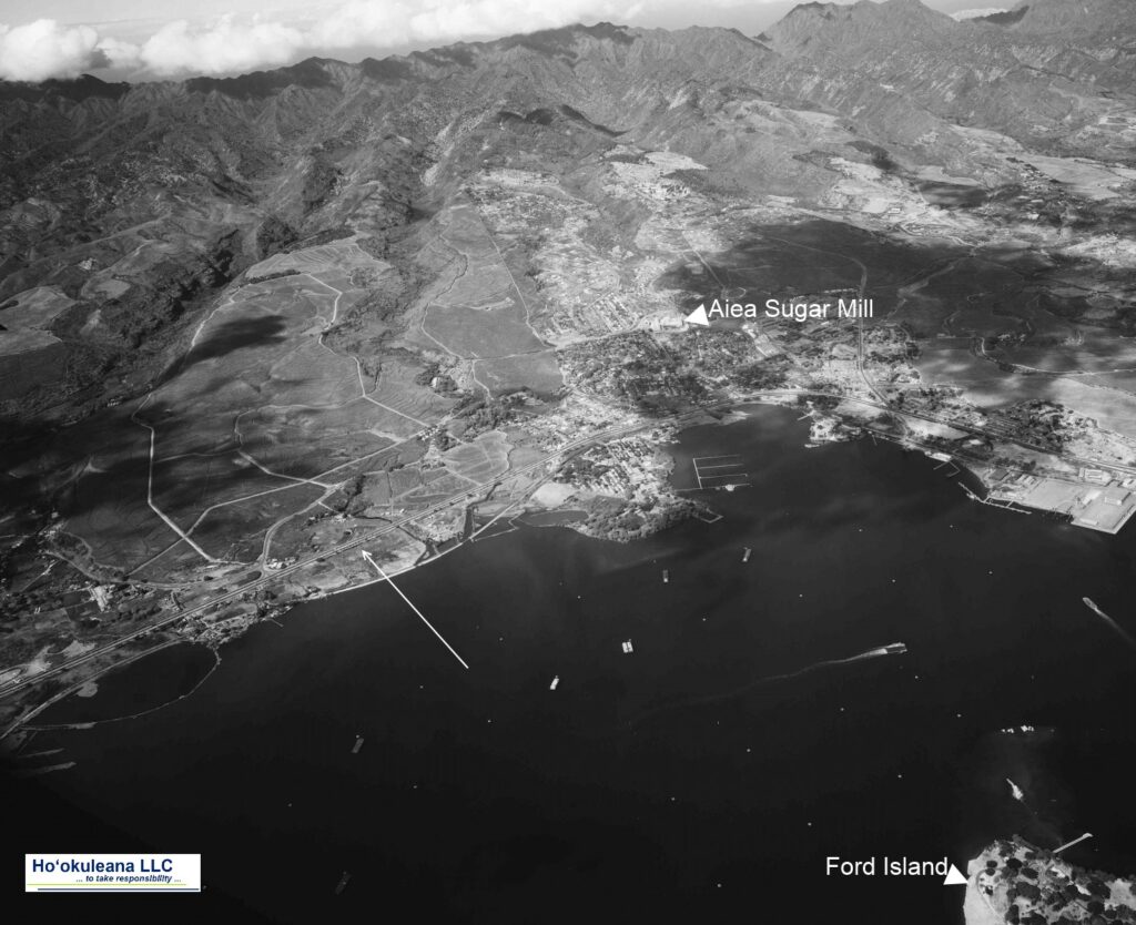
Kalauao Ahupua‘a (the multitude of clouds) extends from the East Loch of Pearl Harbor to the crest of the Koʻolau Range, generally following Kalauao Stream. Kalauao Spring is located near the Pearl Harbor coast.

The Kalauao Spring included two natural springs of percolating water.  In ancient times, the springs irrigated taro loʻi.  Later, the ancient taro lo‘i and ʻauwai (irrigation ditches) were modified and expanded to support rice cultivation.

In 1904, the area was described as, “On the morning of June 2nd, for instance, our destination was Aiea. At ten minutes past seven we boarded the first passenger train going towards Honolulu.”

“For a distance of eight miles the road skirts the shore and then turns landwards or mauka through rice and sugar plantations, Ewa Mill, Waipahu, Pearl City. …”

“Like all rice fields in Hawaii, this one is worked entirely by Chinamen, they alone being able to endure the conditions of location and climate necessary for the cultivation of this cereal.”

“On one side of the railroad track was the broad, muddy inland lake or bay of salt water, Pearl Harbor; on the other side were the terraced plots or fields, flooded to a depth of several inches with water and separated by narrow raised earthen ridges on which the careful Chinaman doubtless succeeded in walking, but which many times proved treacherous to our unsteady feet.”

“A rice plantation, laid out as it generally is on the low flats at the foot of a valley, where mountain streams empty into the sea, is an ideal collecting ground for certain kinds of algae.”  (Thrum 1904)

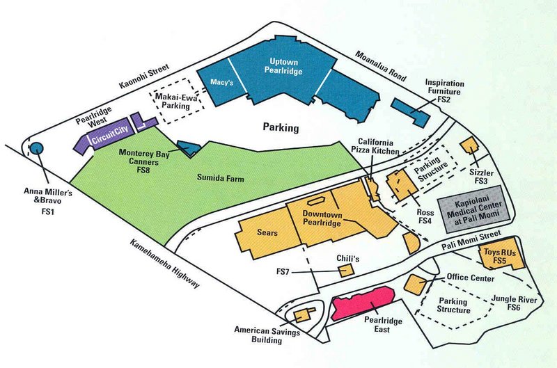
In 1928, Moriichi and Makiyo Sumida began farming assorted wetland produce on a two-acre plot of land at the springs.  Back then, the area of the springs contained many small farms growing similar produce — bananas, taro, rice, and watercress. Through the ensuing years, the Sumida property grew as they acquired neighboring leases and, by 1950, watercress became the sole crop.  (NPS)

A small waterfall along Kalauao Stream, named Kahuawai (or Kahuewai), was located along the coastal trail connecting Honolulu to Waiʻanae.  Kahuawai (water gourd container) was indicated to have been “a favorite resting place exclusively for chiefs”.  (Cultural Surveys)

Kahuawai was a noted bathing place since ancient times and was guarded so that any one did not bathe in it except the chiefs. Later it was used by all. Kākuhihewa’s daughters and the hero Kalelealuaka (their husband) bathed in this pool. Kāʻeokūlani, the chief of Kauaʻi also bathed here when he came to war here on Oʻahu.  (Cultural Surveys)

Loko Opu, a large fishpond (approximately 10.5-acres in size) located in Kalauao along the Pearl Harbor coast, is said to have been built by the chiefess Kalamanuʻia.  (Cultural Surveys)

During the Māhele, much of the lands in the ahupua‘a of ‘Ewa, as in other districts, were awarded to Ali‘i Nui (high chiefs), who were either the grandchildren or great-grandchildren of Kamehameha I.

Half of the ahupua‘a of Kalauao was awarded to Laura Konia (either granddaughter or grandniece of Kamehameha I;) the other half of Kalauao Ahupua‘a was awarded to John Meek, an important merchant in the sandalwood trade.

Today, the Pearl Country Club covers much of the lower section of Kalauao.   Pearlridge Shopping Center is on the lowest side of Kalauao (Pearlridge Uptown was opened in 1972, with an expansion in 1976 to include Pearlridge Downtown.)  Pearlridge surrounds the evidence of the water resources of old, Kalauao Spring that benefits the Sumida watercress farm.

© 2022 Hoʻokuleana LLC

Filed Under: Place Names Tagged With: Hawaii, Oahu, Kalanikupule, Ahupuaa, Kaeo, Ewa, Sumida Watercress, Kalauao, Pearlridge

December 7, 2022 by Peter T Young Leave a Comment

“Something was happening”

The Japanese attack on Pearl Harbor on December 7, 1941 lasted 110 minutes, from 7:55 am until 9:45 am. Japanese naval forces included 4 heavy aircraft carriers, 2 heavy cruisers, 35 submarines, 2 light cruisers, 9 oilers, 2 battleships and 11 destroyers.

The attacking forces came in two waves, the first consisting of 183 aircraft which included 40 torpedo planes, 49 level bombers, 51 dive bombers and 43 fighters. The second wave included 170 planes, 54 of them level bombers, 80 dive-bombers and 36 fighters.  Over 350 Japanese planes were involved in overall attack.

As a result of the December 7, 1941 attack, there were 2,403-people killed and 1,178-wounded. Among the deceased were 2,008-Navy personnel, 109-Marine, 218-Army and 68-civilians.  (navy-mil)

For part of the attack, and aftermath, first, let’s look back.

In 1899, Gorokichi Nakasugi, a Japanese shipbuilder, brought a traditional 34-foot Japanese sailing sampan to Hawai‘i; this led to a unique class of vessels and distinctive maritime culture associated with the rise of the commercial fishing industry in Hawai‘i.

(The term ‘Sampan,’ although usually associate with the Japanese in Hawaiʻi, comes from the Chinese language, meaning three (san) boards (ban,) describing a small simple skiff.)  (VanTilburg)

Japanese-trained shipwrights adapted the original sampan design to the rough waters of the Hawaiian Islands.  The fishermen used traditional live bait, pole-and-line method of fishing and unloaded their catches of aku (bonito, skipjack) and ahi (yellow-fin tuna) at Kewalo Basin.

Local Japanese fishermen opened the commercial tuna industry in Hawaiʻi in conjunction with the innovation of modern packing plants.  It was the ability to can tuna for the distant market which really made possible the expansion and modernization of the fishing fleet.  The industry benefited American canneries.

Vessels began to change with time, as well.  Gasoline engines were fitted into boats beginning in 1905, and more suitable marine diesels by 1927. Shortly thereafter the prominent deckhouse made its appearance.  The Sampans became perfectly adapted to the rough waters between the islands.  (VanTilburg)

The sampan aku fleet was based at Kewalo Basin by 1930, and the McFarlane Tuna Company (later known as Hawaiian Tuna Packers) built a shipyard there in 1929 and a new tuna cannery at the basin in 1933.

By 1940, there were over 450-sampans in the Territory of Hawaiʻi, making the commercial fishery the Islands’ third largest industry behind sugar and pineapple.

That brings us to December 1941, more specifically, December 4 – four sampans (Kiho Maru, Myojin Maru, Shin-ei Maru and the Sumiyoshi Maru) set out for fishing off Oʻahu’s leeward coast.

Later, on the morning of December 7, the Ward (US Destroyer No. 139,) conducting routine antisubmarine patrols in the Hawaiian area, had the distinction of firing the first American gun in anger during the Pacific war.  She searched for a suspected submarine and subsequently fired shots at its conning tower.

(In 2002, the University of Hawaiʻi, Hawaiʻi Undersea Research Lab (HURL) team found the submarine about three to four miles off Pearl Harbor and verified it was hit and sunk by the Ward.  (Burlingame))

Heading home, the Ward soon spotted a Japanese fishing sampan, one of many that was a familiar sight in the waters in the Hawaiian archipelago (not part of the four noted before.)

A fisherman suddenly started waving a white flag perhaps he had seen the determined depth-charge attacks and thought that the Americans would bomb anything that moved. Ward slowed and closed to investigate and took the small craft in tow to turn her over to the Coast Guard for disposition.

Nearing the harbor entrance around 0800, those on deck heard the sound of gunfire and explosions, as smoke began to boil into the skies over Pearl Harbor. (Dictionary of American Naval Fighting Ships)

“Something was happening.”

The Ward had returned and witnessed the December 7, 1941 attack on Pearl Harbor.

On the morning of December 8, newspapers announced that all unidentified boats approaching Oʻahu would be fired upon. It was feared that the local fishing fleet, manned predominantly by Japanese might have had rendezvous with Japanese warships. (Roehner)

Then, the fateful day for the four sampans as they were heading home.  “All of a sudden, there were four or five Army P40s flying over us.  Each picked out a target and attacked.”

The war-planes strafed the four fishing boats (Kiho Maru, Myojin Maru, Shin-ei Maru and the Sumiyoshi Maru) about 2-miles off Barber’s Point, about 10-miles west of Pearl Harbor, killing six civilians (nine crewmen survived the mid-morning attack, but most were wounded – most of the crew on the boats were American citizens.)

After the planes attacked, a destroyer arrived on the scene and dispatched launches to tow the sampans, with the dead and wounded, back to Kewalo Basin.  They were then taken to a civilian hospital where the wounded were kept under armed guard.    (European Stars and Stripes, December 9, 1977)

The dead were brought from the waterfront to Hosoi Funeral Parlor. They were: Ogawa Mataichi, Kaichi Okada, Sutematsu Kida, Kiichi Kida, Kiho Uyehara, Riyozo Okogi.  (Scrapbook of Women of WWII Hawaiʻi)

Again on December 12th, sampans were strafed off of both Kailua and Kohala coasts.  (VanTilburg)

World War II had the single largest impact on the sampan fishing industry.   During the war, the fleet was immediately limited to operating only during certain narrow hours in a few selected near shore areas. This, of course, was devastating to the fishery. By the end of 1942, the annual yield was down by a staggering 99%.  (VanTilburg)

In 1967, 26 years after the incident, the widow of the Kiho Maru skipper received $8,000.  Another received about $2,500 and proceeds from the sale of fish that was in his boat on the day of the attack.  (European Stars and Stripes, December 9, 1977)


© 2022 Hoʻokuleana LLC


Filed Under: Military Tagged With: Hawaii, Oahu, Pearl Harbor, Sampan, Kewalo Basin

December 2, 2022 by Peter T Young Leave a Comment

“East Wind, Rain”

Takeo Yoshikawa, a Japanese spy, arrived in Honolulu on March 27, 1941, aboard the Japanese liner Nitta Maru.  His papers identified him as Tadashi Morimura, the name he was always referred to while in the Islands (and subsequent investigative records.)  (He’ll be referred to here by his real name, Yoshikawa.)

Born on March 7, 1914, Yoshikawa had been approached in 1936 to work as a civilian for Japan’s naval intelligence service: “Since I had been studying English, I was assigned to the sections dealing with the British and American navies. I became the Japanese navy’s expert on the American navy.”

“I read everything; diplomatic reports from our attachés, secret reports from our agents around the world. I read military commentators like Hanson Baldwin (New York Times military affairs editor.)” Yoshikawa also studied Jane’s Fighting Ships and memorized the silhouettes of all the American ships, something that would later prove critical.  (Savela)

Posing as junior diplomat, Yoshikawa was to keep current on the status of the US fleet and its anchorages, reporting his observations to Tokyo by coded telegraph messages.  Thanks to Hawaiʻi’s large Japanese-American population, Yoshikawa easily blended in.

When Kita briefed Yoshikawa, he reminded him, “Don’t make yourself conspicuous; maintain a normal, business-as-usual attitude, keep calm under all circumstances; avoid taking unnecessary risks; stay away from guarded and restricted areas and be aware of the FBI.” (Prange; Savela)

In keeping with his cover, Yoshikawa avoided illegally entering military bases or stealing classified documents. He shunned cameras and notepads, relying instead on memory. He supplemented his observations with items of interest gleaned from daily newspapers.

Yoshikawa familiarized himself with the principal Hawaiian Islands and their military installations, which were concentrated on Oʻahu. He frequently relied on a hired cab driven by John Mikami, a Japanese-Hawaiian who often performed chores for the consulate.  (Deac)

Other times, Yoshikawa was chauffeured by Richard Kotoshirodo, a consular clerk. It did not take long for Yoshikawa to scout out the various US Army and Navy bases on central, southern and eastern Oʻahu. Predictably, the focus of his attention was Pearl Harbor, the nearly landlocked US Pacific Fleet anchorage on the south coast of the island.

The assignment fit into a plan outlined in January 1941 by Combined Fleet Commander Isoroku Yamamoto. The plan called for an aerial assault on Hawaiʻi as the opening move of a war between the United States and Japan. Yoshikawa was to become his country’s only military spy in the islands and Yamamoto’s most valuable source of current information on Oʻahu.  (Deac)

And with its relatively open landscape, sloping elevations, and limited restrictions on movement, he readily compiled useful intelligence. His encyclopedic knowledge of US ships and his methodical charting of their movements made his reports all the more valuable.  His contribution to the Japanese effort was ultimately “an important one.”  (Savela)

Yoshikawa did not work alone.  Later joining him in espionage was a ‘sleeper agent’ Bernard Otto Julius Kuehn and his family, Nazi spies sent to the Islands by Nazi Propaganda Minister Joseph Goebbels.  (Washington Times)

The Kuehns arrived in Hawaiʻi in 1935, they blended in, and waited; no one seriously suspected that Caucasians would carry on espionage for the Empire of Japan, so Kuehn, his wife Friedel, their daughter and son, Hans Joachim, were virtually inconspicuous as a white family on the windward side.

However, every member of the family contributed towards collecting and documenting military activities at Pearl Harbor from 1935 right up to the day the bombs fell from Japanese aircraft.

On December 2, days before the attack, Kuehn provided specific – and highly accurate – details on the fleet in writing. That same day, he gave the consulate the set of signals that could be picked up by nearby Japanese submarines.  (FBI)

At midafternoon on December 6, Yoshikawa made his final reconnaissance of Pearl Harbor from the Pearl City pier.  Back at the consulate, he coordinated his report with Kita, and then saw that the encoded message was transmitted to Tokyo.

At 1:20 am on December 7, 1941, on the darkened bridge of the Japanese aircraft carrier Akagi, Vice Admiral Chui­chi Nagumo was handed the following message:

“Vessels moored in harbor: 9 battleships; 3 class B cruisers; 3 seaplane tenders, 17 destroyers. Entering harbor are 4 class B cruisers; 3 destroyers. All aircraft carriers and heavy cruisers have departed harbor…. No indication of any changes in US Fleet or anything unusual.”  (Savela)

In the early morning of December 7, 1941, Japanese pilots flew toward the island of Oʻahu from six aircraft carriers (the Akagi, Kaga, Soryu, Hiryu, Shokaku and Zuikaku;) two waves of planes attacked various military installations on Oʻahu.

The prearranged coded signal “East wind, rain,” part of the weather forecast broadcast over Radio Tokyo, alerted Japanese Consul General Nagao Kita in Honolulu, and others, that the attack on Pearl Harbor had begun.

The first wave of 183-planes (43-fighters, 49-high-level bombers, 51-dive bombers and 40-torpedo planes) struck its targets at 7:55 am.  The second wave of 167-Japanese planes (35-fighters, 54-horizontal bombers and 78-dive bombers) struck Oʻahu beginning at 8:40 am.

The Japanese consulate staff locked the consulate doors and began burning all their codebooks and classified material. “Smoke was pouring out of the chimney.”   At about 9:30 am, December 7, the consulate staff was arrested and later shipped to Phoenix, Arizona.

By 9:45 am, the Japanese attack on Oʻahu was over.

© 2022 Hoʻokuleana LLC

Takeo Yoshikawa
Japanese Consulate Staff-Honolulu-(NationalArchives)
Japan's Spy in Hawaii-(Barclay)
Nitta-maru_1940
SPY, WIFE, HERO - TAKEO YOSHIKAWA, HIS WIFE, ETSUKO, AND HIS LIFETIME HERO, ADMIRAL TSOROKU YAMAMOTO, SUPREME COMMANDER AND PLANNER OF THE JAPANESE ATTACK FORCE THAT ATTACKED PEARL HARBOR. EXCLUSIVE PHOTO BY RON LAYTNER FOR EDIT INTERNATIONAL.
SPY, WIFE, HERO – TAKEO YOSHIKAWA, HIS WIFE, ETSUKO, AND HIS LIFETIME HERO, ADMIRAL TSOROKU YAMAMOTO, SUPREME COMMANDER AND PLANNER OF THE JAPANESE ATTACK FORCE THAT ATTACKED PEARL HARBOR. EXCLUSIVE PHOTO BY RON LAYTNER FOR EDIT INTERNATIONAL.
Takeo Yoshikawa-(Barclay)
SITTING ON HIS HORSE 'JONNY' THE LEGENDARY PEARL HARBOR SPY, TAKEO YOSHIKAWA, SAID "I WAS BORN IN THE DAYS OF THE GREAT JAPANESE EMPIRE WHEN THE YAMATO RACE WALKED TALL ACROSS ASIA AND BOYS WERE DESTINED FOR GREATNESS." EXCLUSIVE PHOTO COPYRIGHT BY RON LAYTNER, EDI INTERNATIONAL.
SITTING ON HIS HORSE ‘JONNY’ THE LEGENDARY PEARL HARBOR SPY, TAKEO YOSHIKAWA, SAID “I WAS BORN IN THE DAYS OF THE GREAT JAPANESE EMPIRE WHEN THE YAMATO RACE WALKED TALL ACROSS ASIA AND BOYS WERE DESTINED FOR GREATNESS.” EXCLUSIVE PHOTO COPYRIGHT BY RON LAYTNER, EDI INTERNATIONAL.
"IN MY YOUTH I WAS A SAMURAI. I BELIEVED IN WAR AND DEATH IN BATTLE. I SHAPED HISTORY. NOW I AM OLD AND BELIEVE IN PEACE AND LOVE." TAKO YOSHIKAWA, THE PEARL HARBOR SPY, INTERVIEWED BEFORE HIS DEATH IN 1984. WORLD EXCLUSIVE PHOTOGRAPH COPYRIGHT BY RON LAYTNER AND EDIT INTERNATIONAL.
“IN MY YOUTH I WAS A SAMURAI. I BELIEVED IN WAR AND DEATH IN BATTLE. I SHAPED HISTORY. NOW I AM OLD AND BELIEVE IN PEACE AND LOVE.” TAKO YOSHIKAWA, THE PEARL HARBOR SPY, INTERVIEWED BEFORE HIS DEATH IN 1984. WORLD EXCLUSIVE PHOTOGRAPH COPYRIGHT BY RON LAYTNER AND EDIT INTERNATIONAL.
WATCHING THE NEW JAPAN THROUGH HIS WINDOW, THE OLD SPY SAID: "I AM NOT SORRY ABOUT PEARL HARBOR - ONLY THAT JAPAN HAS NOT HONORED ME. ALL THOSE WHO DIED IN THE ATTACK - ALL THE AMERICANS AND THE FEW JAPANESE TOO - THEY DIED FOR THE GLORY OF HISTORY," SAID UNREPENTENT JAPANESE SUPER SPY TAKEO YOSHIKAWA, WHO WAS DIRECTLY RESPONSIBLE FOR PROVIDING JAPANESE FORCES WITH INTELLIGENCE FROM PEARL HARBOR. EXCLUSIVE PHOTO COPYRIGHT BY RON LAYTNER FOR EDIT INTERNATIONAL.
WATCHING THE NEW JAPAN THROUGH HIS WINDOW, THE OLD SPY SAID: “I AM NOT SORRY ABOUT PEARL HARBOR – ONLY THAT JAPAN HAS NOT HONORED ME. ALL THOSE WHO DIED IN THE ATTACK – ALL THE AMERICANS AND THE FEW JAPANESE TOO – THEY DIED FOR THE GLORY OF HISTORY,” SAID UNREPENTENT JAPANESE SUPER SPY TAKEO YOSHIKAWA, WHO WAS DIRECTLY RESPONSIBLE FOR PROVIDING JAPANESE FORCES WITH INTELLIGENCE FROM PEARL HARBOR. EXCLUSIVE PHOTO COPYRIGHT BY RON LAYTNER FOR EDIT INTERNATIONAL.
THE MOST EFFECTIVE SPY IN HISTORYM TAJEI ISGUJAWAM DRUBJS TI FIRGET UB NATSYTANA IB SGUBIJY USKABDM "JAPAN NOW THINKS ONLY OF MONEY AND HOW TO WIN NEW MRKETS," HE SAID SADLY. EXCLUSIVE PHOTO COPYRIGHT BY RON LAYTNER FOR EDIT INTERNATIONAL.
THE MOST EFFECTIVE SPY IN HISTORYM TAJEI ISGUJAWAM DRUBJS TI FIRGET UB NATSYTANA IB SGUBIJY USKABDM “JAPAN NOW THINKS ONLY OF MONEY AND HOW TO WIN NEW MRKETS,” HE SAID SADLY. EXCLUSIVE PHOTO COPYRIGHT BY RON LAYTNER FOR EDIT INTERNATIONAL.

Filed Under: Military Tagged With: Hawaii, Oahu, Pearl Harbor, Bernard Kuehn, Takeo Yoshikawa

  • « Previous Page
  • 1
  • …
  • 23
  • 24
  • 25
  • 26
  • 27
  • …
  • 77
  • Next Page »

Images of Old Hawaiʻi

People, places, and events in Hawaiʻi’s past come alive through text and media in “Images of Old Hawaiʻi.” These posts are informal historic summaries presented for personal, non-commercial, and educational purposes.

Info@Hookuleana.com

Connect with Us

  • Email
  • Facebook
  • LinkedIn
  • Twitter
  • YouTube

Recent Posts

  • Women Warriors
  • Rainbow Plan
  • “Pele’s Grandson”
  • Bahá’í
  • Carriage to Horseless Carriage
  • Fire
  • Ka‘anapali Out Station

Categories

  • Hawaiian Traditions
  • Military
  • Place Names
  • Prominent People
  • Schools
  • Sailing, Shipping & Shipwrecks
  • Economy
  • Voyage of the Thaddeus
  • Mayflower Summaries
  • American Revolution
  • General
  • Ali'i / Chiefs / Governance
  • Buildings
  • Missionaries / Churches / Religious Buildings

Tags

Albatross Al Capone Ane Keohokalole Archibald Campbell Bernice Pauahi Bishop Charles Reed Bishop Downtown Honolulu Eruption Founder's Day George Patton Great Wall of Kuakini Green Sea Turtle Hawaii Hawaii Island Hermes Hilo Holoikauaua Honolulu Isaac Davis James Robinson Kamae Kamaeokalani Kamanawa Kameeiamoku Kamehameha Schools Lalani Village Lava Flow Lelia Byrd Liliuokalani Mao Math Mauna Loa Midway Monk Seal Northwestern Hawaiian Islands Oahu Papahanaumokuakea Marine National Monument Pearl Pualani Mossman Queen Liliuokalani Thomas Jaggar Volcano Waikiki Wake Wisdom

Hoʻokuleana LLC

Hoʻokuleana LLC is a Planning and Consulting firm assisting property owners with Land Use Planning efforts, including Environmental Review, Entitlement Process, Permitting, Community Outreach, etc. We are uniquely positioned to assist you in a variety of needs.

Info@Hookuleana.com

Copyright © 2012-2024 Peter T Young, Hoʻokuleana LLC


Loading Comments...