Images of Old Hawaiʻi

  • Home
  • About
  • Categories
    • Ali’i / Chiefs / Governance
    • American Protestant Mission
    • Buildings
    • Collections
    • Economy
    • Missionaries / Churches / Religious Buildings
    • General
    • Hawaiian Traditions
    • Other Summaries
    • Mayflower Summaries
    • Mayflower Full Summaries
    • Military
    • Place Names
    • Prominent People
    • Schools
    • Sailing, Shipping & Shipwrecks
    • Voyage of the Thaddeus
  • Collections
  • Contact
  • Follow

December 27, 2022 by Peter T Young Leave a Comment

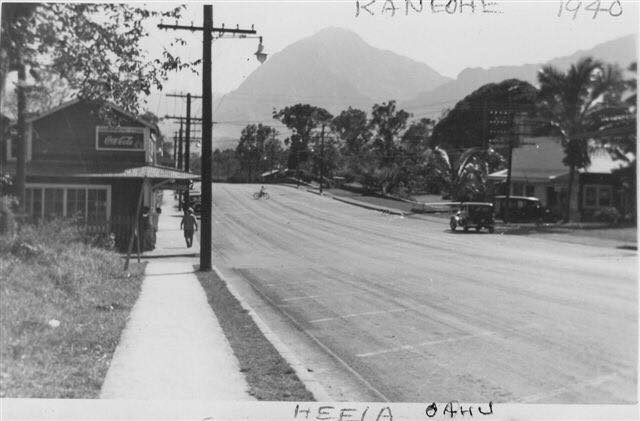
Heʻeia

The nine ahupuaʻa of Kāneʻohe Bay, beginning at the boundary between Koʻolauloa and Koʻolaupoko Districts (west) and moving eastward, are Kualoa, Hakipuʻu, Waikāne, Waiāhole, Kaʻalaea, Waiheʻe, Kahaluʻu, Heʻeia and Kāneʻohe.

The ahupuaʻa of Heʻeia and Kāneʻohe also included portions of Mōkapu Peninsula (Heʻeia runs from the mountains to the sea, but also crosses over a portion of the water in Kāneʻohe Bay and includes a portion of a Mōkapu peninsula across the Bay.)  Heʻeia also includes Moku-o-Loʻe (Coconut Island,) Kahaluʻu includes Kapapa Island and Kualoa includes Mokoliʻi.

The name of the land of Heʻeia is traditionally associated with Heʻeia, the handsome foster son of the goddess Haumea and grandson of the demigod ʻOlopana, who was an uncle of Kamapuaʻa.

Heʻeia was named in commemoration of a tsunami-type wave that washed Haumea and others into the sea – a great tidal wave that “washed (he‘e ‘ia) … out to sea and back” (Lit., surfed, or washed (out to sea,) or swept away.)

They swam until they were exhausted and were finally washed ashore at Kapapa Island in Kāneʻohe Bay. It was the handsome Heʻeia who fell in love with Kaohelo, a younger sister of Pele and Hiʻiaka, whom he met in Koʻolau, Oʻahu.  (Devaney)

In ancient Hawai‘i, fishponds were an integral part of the ahupua‘a food source.  Hawaiians built rock-walled enclosures in near shore waters to raise fish for their communities and families.  Loko iʻa (fishpond) were used for fattening and storing of fish for food and also as a source for kapu (forbidden) fish.  Walled, brackish-water fishponds were usually constructed on the reef along the shore and one or more mākāhā (sluice gate.)

Heʻeia Fishpond’s wall was one of the longest, extending nearly a mile.  As a large pond, it is subject to considerable evaporation, increasing salinity in the pond; as such, fresh water is added.  Heʻeia is somewhat unique in that it has mākāhā gates on the mauka wall to control the flow of fresh water.

Kalo (taro) was a main staple in the diet of nearly all Hawaiians prior to European contact and was extensively cultivated.  As early as 1789, Portlock described this area:

“… the bay all around has a very beautiful appearance, the low land and valleys being in high state of cultivation, and crowded with plantations of taro, sweet potatoes, sugar-cane, etc. interspersed with a great number of coconut trees ….”

The region had a considerable amount of land cultivated in taro up through the early-1800s.  “Southeastward along the windward coast, beginning with Waikāne and continuing through Waiāhole, Kaʻalaea, Kahaluʻu, Heʻeia and Kāne’ohe, were broad valley bottoms and flatlands between the mountains and the sea which, taken all together, represent the most extensive wet-taro area on Oʻahu.” (Handy, Devaney)

The rains that sweep through here have been memorialized in poetry and song.  A traditional mele honoring Kaumuali‘i suggests “the sound of heavy rain drops on dry leaves, or dry thatching of the pandanus leaf, … of the rain accompanying the koʻolau wind, which calms the troubled waters”.

This “heavy-sounding rain” of the Koʻolau has been transformed into a poetical saying, “Ka ua kani koʻo o Heʻeia, The rain of Heʻeia that sounds like the tapping of walking canes”.  (Fornander)

During the early historic times, many of the ruling chiefs favored this area as their place of residence. Kahahana the ruler of Oʻahu sometimes resided there. Kahekili after defeating Kahahana lived in Kailua, Kāneʻohe and Heʻeia.

The Sacred Hearts Father’s College of Ahuimanu was founded by the Catholic mission at Ahuimanu, Heʻeia in 1846.  “Outside the city, at Ahuimanu, Maigret has now a country retreat that he refers to by the Hawaiian word māla.  It is a combination garden, orchard and kitchen garden. …”

“The venerable bishop has built his own vineyard and planted his own orchard … His retreat in the mountain, his “garden in the air” as he terms it, is a pleasant and profitable sight … When the pressure of events allows it, Maigret takes refuge there.” (Charlot)

One of its students, Damien (born as Jozef de Veuster,) arrived in Hawaiʻi on March 9, 1864, at the time a 24-year-old choirboy.  Determined to become a priest, he had the remainder of the schooling at the College of Ahuimanu.  Bishop Maigret ordained Father Damien at the Cathedral of Our Lady of Peace in 1864 and later assigned him to Molokaʻi.  In 2009, Father Damien was canonized by Pope Benedict XVI.

The earliest of the modern large commercial agricultural ventures started with the cultivation of sugar cane in Kualoa in the 1860s. By 1880, three more sugar companies had emerged in Kahaluʻu, Heʻeia and Kāne’ohe. Heʻeia Sugar Company (also called Heʻeia Agricultural Co. Ltd) operated from 1878 to 1903.

In 1880, the region reported 7,000-acres available for cultivation; in 1883 a railroad was installed at Heʻeia, and by the summer of that year it was noted that the railroad had allowed a much greater amount of land to be harvested, even allowing cane from Kāneʻohe to be ground at Heʻeia; however, the commercial cultivation of sugar cane was short-lived.  (Devaney)

Rice cultivation did not occur in earnest until the decline of sugar, and in 1880 the first Chinese rice company started in the nearby Waineʻe area. Abandoned systems of loʻi kalo were modified into rice paddies. The Kāneʻohe Rice Mill was built around 1892-1893 in nearby Waikalua.

Another commercial crop, pineapple, was also grown here, starting around 1910.  By 1911, Libby, McNeill & Libby gained control of land here and built the first large-scale cannery with an annual capacity of 250,000-cans at nearby Kahaluʻu; growing and canning pineapples became a major industry in the area for a period of 15 years (to 1925.)

The US military first established a presence on the Mōkapu peninsula in 1918 when President Woodrow Wilson signed an executive order establishing Fort Kuwaʻaohe Military Reservation (the western portion of Mōkapu is within the Heʻeia ahupuaʻa.)

Today, Marine Corps Base Hawaiʻi continues to serve as a fully functional operational and training base for US Marine Corps forces. The Marine Corps Air Station (MCAS) here operates a 7,800-foot runway (on the ahupuaʻa of Heʻeia) that can accommodate both fixed wing and rotor-driven aircraft.

With World War II underway, the Navy recognized the need to be able to communicate across the Pacific.  In 1942, a group of radio experts determined a superpower radio station with across-the-Pacific range might be built provided that the antenna could be raised high enough above the ground.

The solution was to find a topographic feature that would act like the “unbuildable” tall tower.  Using technology developed pre-World War I, they strategically positioned four Alexanderson Alternators; one was located in Haiku Valley in Heʻeia.  Haiku Valley with its horseshoe shape and sheer side-walls filled the prescription perfectly.

To build it, mountain climbers pounded spikes into the vertical cliff, then added wooden stairs up the mountain.  A lift to haul up materials was added and they strung cables across the valley.  The Alexanderson Alternator radio system, transmitting Morse code across the Pacific, was operational in 3-months.  A reminder of that facility is the Haiku Ladder, Haiku Stairs – the Stairway to Heaven (a 3,922-step ladder/stairway ascending the summit of the Koʻolau mountain range.)

Today, Windward Mall, portions of Windward Community College, Valley of the Temples, Tetsuo Harano Tunnels (H3,) Hawaiʻi Institute for Marine Biology, MCBH, Heʻeia Kea Small Boat Harbor and a bunch of other folks call Heʻeia home.

© 2022 Hoʻokuleana LLC


Filed Under: Military, Place Names, Schools Tagged With: Heeia, Koolaupoko, Marine Corps Base Hawaii, Moku O Loe, Windward, Ahuimanu, College of Ahuimanu, H3, Hawaii, Mokapu, Oahu, HIMB, Haiku

February 25, 2022 by Peter T Young 1 Comment

Moku O Loʻe

Three brothers, Kahoe, Kahuauli and Pahu, and their sister, Loʻe, were sent from ʻEwa to live in Kāneʻohe. Loʻe lived on Moku o Loʻe (Loʻe’s island). Kahuauli was a farmer at Luluku (in the area of Puʻu Kahuauli). Kahoe was a farmer near Haiku and Keaʻahala; and Pahu was a fisherman in Pohakea (in the area of Puʻu Pahu). (Jokiel, HIMB)

When Pahu went to visit Kahoe he always received poi from him. In return, he gave Kahoe small leftover baitfish instead of good large ulua that he caught daily. Kahoe eventually learned of Pahu’s deceit from Loʻe who came over from her island to visit him. (Jokiel, HIMB)

Several months later there was a famine and everyone hid the smoke from their cooking fires to avoid having to share their food with others. Kahoe was able to conceal his smoke in his valley. It traveled one to two kilometers before appearing on the summit of the cliff.

One evening Loʻe caught Pahu looking longingly at Keaʻahala and said, “So, standing with eyes looking at Keahiakahoe (Kahoe’s fire).” To this day the peak carries this name. (Jokiel, HIMB)

Surrounding Kāneʻohe Bay landward are, again, the Koʻolau Mountains. Seen to the right of Mōkapu Peninsula’s Puʻu Papaʻa and in the foreground is Puʻu Pahu, a hill on the mainland overlooking Moku o Loe. Lilipuna Pier, which provides access by boat to Moku o Loʻe, is located here. This headland is known as Pōhākea.

To the right and continuing southwest are the peaks of Puʻu Kōnāhuanui, Puʻu Lanihuli, Puʻu Kahuauli and Puʻu Keahiakahoe. These surround the large valley of Kaneohe.

It came under the ownership of Bishop Estate. In 1933, Chris Holmes, owner of Hawaiian Tuna Packers (later, Coral Tuna) and heir to the Fleischmann yeast fortune, purchased the island for his tuna-packing factory.

Later, Holmes tried to transform Coconut Island into his own private paradise. He enlarged the island, built the ponds, harbors and seawall surrounding the island. He also planted large numbers of coconut palms which gave rise to its popular name, “Coconut Island”.

Holmes bought a 4-masted schooner in Samoa, the Seth Parker, and had it sailed north to Hawai‘i. It leaked so much on the trip that it was declared unseaworthy. He permanently moved the Seth Parker to Coconut Island. This boat was used in the movie “Wake of the Red Witch”, starring John Wayne. (HIMB)

Christian Holmes built outdoor bars at various points around the island. He had a bowling alley built, and reconstructed a shooting gallery on the island that he had bought at an amusement park in San Francisco. (HIMB)

That’s not all. Coconut Island even housed a small zoo for a short time. Animal residents included: donkeys, a giraffe, monkeys and a baby elephant. Upon Holmes’s death, these animals became the basis for the Honolulu Zoo (along with the Honolulu Bird Park at the Kapiʻolani Park site).

The baby elephant was known as “Empress” at the zoo and died of old age in 1986. Zookeepers believe her to be the longest living captive elephant. (HIMB)

After Chris Holmes passed away in 1944 Coconut Island was used for an Army Rest & Recreation center until it was bought by five investors. Eventually Edwin Pauley became principal owner.

During World War II the army used the island as a rest camp for combat officers, building barracks and adding electrical, plumbing and a sewage disposal plant and improving the dock facilities. After the war, Holmes put the island up for sale and Edwin W Pauley, his brother Harold, SB Mosher, Poncet Davis and Allen Chase (wealthy oil men) purchased it for $250,000.

Pauley, the leader of the group, was a Los Angeles oilman, former treasurer of the National Democratic Party and Reparations Commissioner after the end of World War II.

Through a collaboration of Paul R Williams and A Quincy Jones, a concept plan was developed to use the island as a millionaire’s playground and exclusive resort – Coconut Island Club International.

Described by Ed Pauley as the ultimate “retreat for tired businessmen,” the drawing shows the four-story, 26-suite hostel and proposed amenities. Swimming pools, boathouses, tennis courts, bowling alley, and a lookout tower with a view of Kaneohe Bay and Oahu were all part of the master plan.

Forty-five minutes by speedboat from Honolulu, Coconut Island was the south sea location of the 1940s paradise for five wealthy American businessmen.

With year-round temperate weather, luxuriant plantings, natural wading pools and a world-class dock for expensive pleasure boats, the island was the perfect setting for a private resort where “members and their families can enjoy vacations under the most delightful conditions possible anywhere in the world.” (Los Angeles Times, February 16, 1947)

Their vision of the resort island as an exclusive private club, a “combination millionaire’s playground and crossroads hostel for high level international citizens,” owned and frequented by “substantial people – important people, if you will, notables, or call them what you like…” proved to be too restrictive to support the grand building project. Soon after the drawing was completed, the venture was abandoned.

Eventually, Edwin Pauley, bought out the interests of the other four and became the sole owner of the island. Here, his family spent their summers. Many famous people spent time on Coconut Island as a guest of Edwin Pauley. Some of these include: Harry Truman, Lyndon B Johnson, Red Skelton, Richard Nixon and Ronald Reagan.

By the early 1950s Edwin Pauley was approached by the marine biologists at the University of Hawaii’s fledgling Marine Laboratory to use the island’s boat facilities as a base for their research vessel. Pauley responded, “We have a lot of other facilities here. Could you use anything else on the Island?” (Kamins, A History of the UH)

He leased the necessary land to the State “rent free.” The original main laboratory building burned down. Pauley donated the funds to replace it (it was completed in 1965.)

Following the death of Edwin Pauley in the early 1980s, the island was put up for sale. A Japanese real estate developer, Katsuhiro Kawaguchi, offered $8.5 million in cash and purchased the island.

Later, the Pauley Foundation and Trustees approved a grant of $7.615 million to build a marine laboratory to be named the Pauley-Pagen Laboratory. The Pauley family provided the UH Foundation with the $2 million necessary to buy the private portion of the island from Mr. Kawaguchi.

Instead of a millionaire’s playground, the island became a haven for world-class scientists at the Hawaiʻi Institute for Marine Biology (HIMB.) While some generally refer to the island as “Coconut Island,” (and it was featured in the opening scene of Gilligan’s Island, a 1960s television sitcom,) let us not forget its original name, Moku O Loʻe.

© 2022 Hoʻokuleana LLC
 

Filed Under: Place Names, Economy, General Tagged With: Hawaii, Oahu, Kaneohe Bay, Kaneohe, Coconut Island, Moku O Loe, HIMB, Edwin Pauley, Hawaii Institute for Marine Biology, Gilligan's Island

August 21, 2014 by Peter T Young Leave a Comment

Kokokahi

Dr Theodore Richards’ first position in Hawaiʻi was teacher of the first class to graduate from the Kamehameha Schools and also as an instructor of music and athletic coach.

He served as principal of the Kamehameha Schools for five years (replacing William Oleson, Kamehameha’s 1st principal.) Richards married Mary C Atherton in Honolulu, June 29, 1892. They had four children, Ruth (Mrs Frank E Midkiff,) Joseph Atherton, Herbert M and Mary Theodora Richards.

In 1927, Richards envisioned a community center and camp ground where people of all races could come together as “one blood” or “kokokahi”.

Initially, the Richards’ camp started on Moku O Loʻe (Coconut Island.)  Chris Holmes, Fleishman Yeast heir, offered to buy the Bishop Estate lease from the camp and to take over the island as a private residence.

With the money from selling the lease, Richards established a multi-racial community by setting out houselots for weekend cabins across the Bay; it had mountains for hiking and the bay for swimming and the land between for the camp itself.  (Taylor)

He established a garden there (now the independent Friendship Garden;) later, the Dudley Talbott Trail was added (about half-mile loop through lower Kokokahi Valley mauka of Kāneʻohe Bay Drive. )

Camp Halekipa was established and later merged with Theodore Richards’ combined conference, camp and vacation home area for all Christians, and called Kokokahi as part of the YWCA.

In a time when it was the custom for communities to be segregated by race, Kokokahi was an unprecedented effort to breakdown racial barriers.  The YWCA national commitment to eliminating racism is in close harmony with Dr Richard’s.

The new camp offered conferences and camp outings for such diverse organizations as church groups, the University of Hawaiʻi sororities, the Salvation Army and Home Demonstration Clubs.

In 1936, the Juliette Atherton Trust built Atherton Hall on the YWCA property.  It overlooks Kāneʻohe Bay, with floor to ceiling glass doors and a lanai that wraps around the building.

Today, Atherton Hall is used for group retreats or meetings, as well as a site for weddings; it has a full catering kitchen.   Hale Nanea Lodge and nearby island-style cottages provide sleeping quarters for overflow.

Hale Nanea Lodge is a modern style lodge that can accommodate up to 60-guests in five dorm style rooms (with 12-camp-style single bunk beds per room.)  Hale Nanea is equipped with its own kitchen, meeting space and men’s and women’s restrooms.

Originally built in 1933, nearby cottages have camp-style single beds and bunk beds and share a common area restroom with showers.  The cottages have electricity and an outdoor picnic area with barbeque grills and sink.

During WWII, Kokokahi was used as a rest camp by the military.  In 1968, renovations were begun to include a physical education building for indoor classes, an arts and crafts facility, a large multipurpose building and a marina.

Fully renovated in 2001, Midkiff Gymnasium is a modern multi-purpose gym.  The unique sliding doors create an open air area, allowing ocean and mountain views.  The gym has a sports floor covering and a college regulation size basketball court.

Today, Kokokahi offers YWCA members a place to participate in cultural, educational and recreational activities together. The camp recently completed another renovation, getting a much-needed face-lift.

Located on Kāne’ohe Bay, member families have access to over 11-acres of waterfront property which includes a full-size gymnasium, a functional kitchen and dining area, a pool with locker rooms, overnight cabins and multiple classrooms and meeting spaces.  (Information here is from YWCA, Kokokahi.)

The image shows Kokokahi and the Atherton Home (Hall.)  In addition, I have added other related images in a folder of like name in the Photos section on my Facebook and Google+ pages.

Follow Peter T Young on Facebook  

Follow Peter T Young on Google+    

Follow Peter T Young on LinkedIn   

© 2014 Hoʻokuleana LLC

Filed Under: General, Buildings, Economy Tagged With: Camp Halekipa, William Brewster Oleson ;, Theodore Richards, Hawaii, Kamehameha Schools, Oahu, Kaneohe Bay, Koolaupoko, YWCA, Moku O Loe, Kokokahi

Images of Old Hawaiʻi

People, places, and events in Hawaiʻi’s past come alive through text and media in “Images of Old Hawaiʻi.” These posts are informal historic summaries presented for personal, non-commercial, and educational purposes.

Info@Hookuleana.com

Connect with Us

  • Email
  • Facebook
  • LinkedIn
  • Twitter
  • YouTube

Recent Posts

  • For the Birds
  • James Otis
  • Raising the United States Flag
  • Kamehameha III’s Secret Agreement of US Annexation
  • Daguerreotype
  • Wahiawā
  • Math’s Life Lessons

Categories

  • General
  • Ali'i / Chiefs / Governance
  • Buildings
  • Missionaries / Churches / Religious Buildings
  • Hawaiian Traditions
  • Military
  • Place Names
  • Prominent People
  • Schools
  • Sailing, Shipping & Shipwrecks
  • Economy
  • Voyage of the Thaddeus
  • Mayflower Summaries
  • American Revolution

Tags

1846 Albatross Albert Gerbode Aloha Camp Battery Opaeula Blue Men Campbell Building Carl Carlsmith Charles I Christmas Tree Communications Constance Frederica Gordon-Cumming Dollar Steamship Francisco Coronado French Hale O Lono Hana Pier Heiau Kalama Tract Kamanawa Kamehameha IV Kanakea Pond Kauai Kukuihoolua Kukuiokane Lunalilo Home Mao Merrymount Milolii Missionaries Mitchellism Old Courthouse Polly Thomson Polynesian Resolution Samuel Damon Ship Trap Socialism Teacherages Tot Vancouver Island Veterans Memorial Freeway Waiohinu Witch WWII

Hoʻokuleana LLC

Hoʻokuleana LLC is a Planning and Consulting firm assisting property owners with Land Use Planning efforts, including Environmental Review, Entitlement Process, Permitting, Community Outreach, etc. We are uniquely positioned to assist you in a variety of needs.

Info@Hookuleana.com

Copyright © 2012-2021 Peter T Young, Hoʻokuleana LLC


Loading Comments...