William Herbert (Willie – WH) Shipman (1854-1943) was born on December 17, 1854, at Lahaina, Maui to William Cornelius Shipman and Jane Stobie Shipman. Willie’s parents had signed up as missionaries destined for Micronesia.
They stopped over at Lahaina, Maui because his mother was due to deliver Willie within 2 months. His parents then took a mission station in Kaʻū, Hawaiʻi, based in Waiʻōhinu.
Willie Shipman was inducted into the Paniolo [Hawaiian Cowboy] Hall of Fame in 2017. (Hawai‘i Cattlemen’s Council) “Originally old man Shipman [WH Shipman] had 72,000 acres that ran from the ocean up to the National Park. … He needed money so he sold off quite a bit of that land from actually from the Puna Road up to the National Park boundary.” (Devine, Pili Productions)
Of Shipman’s four ranches, Pu‘u ‘Ō‘ō was the most productive, being both large and well-watered. An estimated 5,000 head of cattle ran at Pu‘u ‘Ō‘ō, 1,500 at Keauhou, and only ‘a few’ at ‘Āinahou. (Langlas)
Kea‘au Ranch was once well maintained, but by about the 1930-40s it was neglected and produced few cattle. “[I]t was categorized as a ranch, but it was more like a wild cattle operation. You know, it wasn’t controlled like Pu‘u ‘Ō‘ō.” (Devine, Pili Productions)
Pu‘u ‘Ō‘ō Ranch covered 23,000 acres between the 5,000 to 6,500 feet elevation. (Tuggle) Pu‘u ‘Ō‘ō Ranch was first established by John T Baker, a Hawaiian-Tahitian-Caucasian protege of Kalākaua. (Langlas)
Baker came to Hawai‘i Island in 1886 when his high-ranking wife, Ululani, was appointed governess of the island. He became a successful rancher and businessman in Hilo, and in 1892-93 served as Hawai’i Island governor.
Baker obtained a lease in Pi‘ihonua in 1887 and must have started ranching at Pu‘u ‘Ō‘ō some time after that. ‘He had built some fences, and about 600 head of mixed cattle, including some Longhorns, were found on the ranch at that time.’ (Henke) Baker used to go up to the ranch every September with an entourage. (Langlas)
(Baker “is best known, perhaps, as the original of the statute of King Kamehameha, for which he was asked to pose, due to the striking likeness to the ancient ruler.” (Advertiser, Sep 8, 1921) “Likeness refers to a likeness of features rather than of body.” (Charlot))
In 1899, Baker sold the ranch lease to Shipman. Shipman introduced Hereford bulls to upgrade the stock and increased the number of cattle. Shipman expanded the ranch to 23,000 acres, including the upper portions of all the ahupua’a owned by the sugar plantations north to Honohina. (Langlas)
In the early part of the century, the ranch included two government leases in Pi‘ihonua and leases of sugar plantation lands to the north in the ahupua‘a of Pauka‘a, Pāpa‘ikou, Makahanaloa, Hakalau Nui and Honohina.
Two smaller parcels were bought in fee simple, an 80-acre piece with a spring on it makai of the Pu‘u ‘Ō‘ō ranch house, and a 500-acre parcel in Pāpa‘ikou which contained the old Hitchcock house at Pua ‘Ākala.
In the 1940s the ranch got the lease of Kipuka ‘Āinahou in Humu‘ula, just south of the Humu‘ula Sheep Station, and ran cattle there until about 1950.
Pu‘u ‘Ō‘ō Ranch was part of WH Shipman’s larger operations, mostly centered in Puna. Shipman had a sugar plantation at ‘Ola‘a, with the mill at Kea‘au. He had three ranches in Puna: Kea‘au Ranch on the lava land of Kea‘au ahupua‘a, Keauhou Ranch north of Kilauea Crater, and ‘Āinahou Ranch south of Kilauea Crater. (Langlas)
There were three stations built on Pu‘u ‘Ō‘ō Ranch: the main Pu‘u ‘Ō‘ō headquarters and the Puakala house station, which were built early, and the Saddle House, built later.
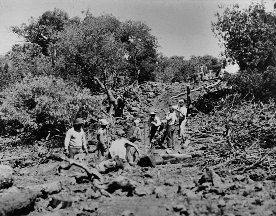
In the 1940s, there were permanent personnel (mostly Japanese) at the ranch responsible for fencing, maintaining the ranch houses, breaking horses, and watching the cattle. Many of the cowboys, who did the driving, branding, and so on, were based at Kea‘au or at Keauhou Ranch and only came up when there was a big job to do; these cowboys were mostly Hawaiian and Portuguese. (Langlas)
The Pu‘u ‘Ō‘ō headquarters had a koa ranch house for the owners, a couple of bunkhouses and a cottage for the cowboys and fence-men, a stable, and barn. The Puakala station had a koa house built by Hitchcock, a couple bunkhouses, and a barn. The cowboys lived up there when they worked that end of the ranch. (Gene Olivera, Langlas)
“In Puu ‘O‘o we had one, two, three bunk houses for the cowboys. For the cowboy and the fencemen. We had the whole house. In Puakala we had another three house, you know counting the big house eh.”
“[W]e had all the cowboys. We had about 33, 34 cowboys at that time. Yeah, used to stay up there, live up there [at Puu ‘Ō‘ō]. But after they made the Saddle road good, most of the boys that married, they came home eh. They don’t sleep out, only us the single ones used to stay up there.”
“So the one that fencemen, ah they, most of the time they kept outside the fence line where they live to the job. So they camp out there. They stay yeah. Where had the water gulch, come down where they get water to take a bath and all that. Then when they want water they come up the house because they had spring water at Puu ‘Ō‘ō house.” (Olivera, Pili Productions)
In the early days of the ranch (probably beginning in 1903, about the time the railroad was completed up to Glenwood), the cattle were driven to market down the Pu‘u ‘Ō‘ō – Volcano Trail to Keauhou Ranch, then down to Glenwood Station where they were loaded onto railroad cars and shipped down to Kea’au or Hilo. (Langlas)
“The Hilo Railroad Company was chartered May 28, 1899. The road has been constructed from Waiakea, at the east side of Hilo Harbor, to Kapoho, in the district of Puna, a distance of 24 miles.”
“On this line, and 7 miles out from Hilo, is the Olaa Sugar Company’s mill. From this point the railroad runs through Keeau and Olaa to the 22 milepost [Glenwood] on the Volcano road, 9 miles from the Volcano House. … This part of the line is nearly constructed, and will probably be finished by January 1, 1903.” (Report of the Governor, 1902)
After that, the cattle were still driven down to Volcano, but from there they were trucked down to Kea’au. Once Saddle Road was built, in 1943, Shipman trucked the cattle down that way instead. (Langlas)
Shipman also had a controlling interest in the Hilo Meat Company, which slaughtered most of the cattle from Big Island ranches (other than Parker Ranch) and which supplied the local market. The cattle were slaughtered al Kea‘au and the meat was sold at Hilo Meat Company on Front Street in Hilo.
“I managed the Hilo Meat Company for thirty-nine years. … Shipman had a controlling interest in the meat company and I was working for the meat company. But I was also, in fact Shipman paid half my salary and the meat company paid half my salary when I first started with the meat company.”
“Shipman and Kapapala [owned by Brewer] and Kukaiau, [owned by] Davies [shipped cattle to Hilo Meat], and we bought cattle from a lot of independents, little Hamakua people and all that, C.L. Chow at one time who was involved with the Standard Meat Market.”
“Parker Ranch had an interest in Hilo Meat Company’s small stock holding. And they really didn’t ship cattle here. They really set up Hilo Meat to buy cattle from everybody else. I mean this island was the only island that produced more then it could take care of itself.” (Devine, Pili Productions)
“They had to ship to Honolulu. And Parker Ranch shipped all their cattle to Honolulu. Yeah, to Hawaii Meat Company that they had a controlling interest in, in other words to, if they started dumping cattle on this island that’d be chaos.”
“Too much produced and no markets so Mr. Carter, AW Carter, who was a trustee of Parker Ranch, who was quite an astute person and he figured out that they’d better not, that it didn’t take much figuring that they’d better ship all their cattle to Honolulu.”
“Otherwise there’d be too much competition here. So he set up, he was the one was instrumental in setting up Hilo Meat Company and getting the various ranchers to take stock in it and let Hilo Meat control more or less what was sold on this side of the island”. (Devine, Pili Productions)
Within the Hakalau Forest area as the juncture of three of the big ranches of east Hawai‘i (Parker Ranch to the uplands in Humu‘ula, Kuka‘iau Ranch to the north in Maulua Nui and beyond, and Pu‘u ‘Ō‘ō Ranch to the south). (Tomonari-Tuggle) However, mauka ranching here started to phase out.
In 1985, the Fish & Wildlife Service, with the active involvement and support of The Nature Conservancy, purchased Shipman Ranch lands and established the Hakalau Forest National Wildlife Refuge. Later, other nearby privately owned parcels were purchased or donated to the refuge.