Images of Old Hawaiʻi

  • Home
  • About
  • Categories
    • Ali’i / Chiefs / Governance
    • American Protestant Mission
    • Buildings
    • Collections
    • Economy
    • Missionaries / Churches / Religious Buildings
    • General
    • Hawaiian Traditions
    • Other Summaries
    • Mayflower Summaries
    • Mayflower Full Summaries
    • Military
    • Place Names
    • Prominent People
    • Schools
    • Sailing, Shipping & Shipwrecks
    • Voyage of the Thaddeus
  • Collections
  • Contact
  • Follow

December 29, 2024 by Peter T Young Leave a Comment

The Big Fence on the Big Island

“Captain George Vancouver brought the first cattle to Hawaii from California in 1793-1794. They were landed and liberated at Kealakekua, South Kona on the Big Island. As with other introduced animals of the same period, a rigid “kapu” was placed on them in order to permit them to multiply.”

“This they did with a vengeance and within a comparatively short span of years they became quite common on all the islands, particularly on Hawaii where they found many hundreds of acres of good pasture lands.”

“Over a period of many years they were slaughtered by men employed for this purpose by the King, principally for their hides, which at one time formed one of the principal articles of export from Hawaii.”

“Experts were employed by the King to go into the mountains to shoot and rope these animals. Only a small amount of the meat was used, some of it being salted and sold to the whaling ships wintered in these water at that time.”

“Many of them were trapped in “pitfalls” similar to the one which David Douglass lost his life on the slopes of Mauna Kea in 1834.” (Bryan, “Wild Cattle in Hawaii” Paradise of the Pacific (1937))

“For the past twenty years the attention of our Government and of this Forestry Bureau has been called to the destruction of our Native forests on Government lands in particular. … It is become a serious problem with us.”

“Large areas of Public Forests are annually destroyed by fire, orginating [sic] in many instances by cattlemen setting fire to the ferns and underbrush to improve their pasture. …  If the cattle are not taken away soon it will be but a short time when this Native forest will be destroyed, and the water supply on the low land diminished.”

“‘[C]attle seem to be the principal enemy of the forests.’  [Sheep also damage the forest habitat]  .By way of countering this threat, [it was] recommended that large parts of the government forest lands …”

“… ‘should be fenced off at once, for the purpose of preserving the living and growing timber and promoting the younger growth of fern and underbrush.’” (Report of the Minister of Interior to the President of the Republic of Hawaii for the Biennium, Ending December 31, 1899; LRB, 1965)

Then came “The Big Fence on the Big Island” … The Territorial Division of Forestry intensified efforts to eradicate feral sheep from the Mauna Kea Forest Reserve in the 1930s after noticing a lack of natural regeneration and damage to māmane trees caused by sheep.

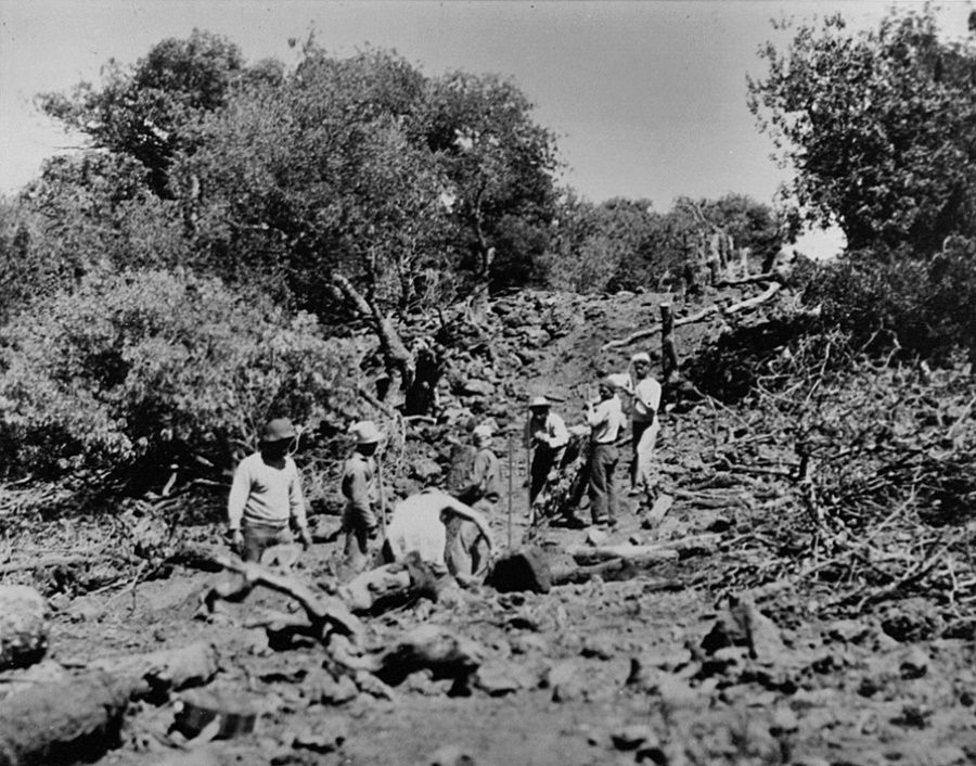
With the help of the Civilian Conservation Corps (CCC), territorial foresters built a 55-mile fence around Mauna Kea in 20 months. It was 4.5-foot tall galvanized stock wire stretched between large māmane posts. (DLNR)

“On the 29th of January, 1937, the longest fence in the Territory of Hawaii was completed by CCC boys. It is around the entire boundary of the Mauna Kea Forest Reserve – the second largest reserve in the Hawaiian Islands.”

“This project, which is part of the Territorial Division of Forestry’s conservation program, was done under the direction of Project Superintendent W.A. Hartman. …  Much credit is due … to the enrollees who worked under them, for the fine accomplishment.”

“Actual construction work was started in June of 1935. A total of twenty months was required to complete the work on the fence which has a total length, including necessary corrals, of fifty-five and one-half miles. Eighteen thousand five hundred and thirty-six man-days were expended on all work connection with this project.”

“A great deal of preliminary work was required before the actual construction of the fence began. First, it was necessary to build many miles of horse and truck trails and tractor roads.”

“In connection with the fence line alone nearly sixty miles of horse-trails were constructed. This trail was used to pack in the fence wire and other supplies. It was made permanent for future use in fence patrol and wild animal eradication work.”

“Most of the fence work was above the eight thousand foot contour. Camp locations had to be selected, shelters constructed, and water tanks installed. These camps were located as close to the fence lines as possible and placed at intervals around the mountain approximately four miles apart.”

“This made the maximum distance from camp to work about two miles each way. At each camp site it was necessary to construct a corral for the work animals. Practically all feed, and part of the water, for these animals, had to be transported to the camp site.”

“Nine line camps were used. Seven of them had to be constructed in advance. These camps were made on the same plan; one small building with watertanks alongside in which could be stored between six and eight thousand gallons of water. The building was used as a cook-house and store-room. The boys lived in tents.”

“During the winter months it becomes quite cold on Mauna Kea and it was found that seven blankets per boy was not too much cover.”

“Frequently the thermometer registered below freezing and at the Puu Loa Camp last February it was necessary to stop work for three days due to an exceptionally heavy fall of snow which covered the ground in that section and prevented work on the fence line.”

“The completion of this fence concludes one of the most important conservation projects attempted by the CCC in the Territory of Hawaii. It completely encloses and protects a reserve area containing approximately one hundred thousand acres. “

“The important Wailuku River – which furnishes the water-supply for the City of Hilo – as well as several other large streams that supply water to Hilo and Hamakua Districts, have their source within this area.”

“This reserve has, for many years, been overrun with wild sheep, there being an estimated population of about forty thousand. These animals do much damage and of recent years have effectively prevented any natural reproduction of the predominating tree growth – Mamani.”

“With this new fence completed it is now possible to conduct drives and reduce the number of these animals to a minimum. In a recent drive, held since the fence was completed, over three thousand wild sheep were captured and killed in a single day.”

“After these animals are exterminated we can expect considerable assistance from nature in our reforestation work. On a small scale this fact has already been demonstrated so we fell assured of ultimate success.”

“In some sections, where seed trees are lacking, it will be necessary to assist nature with reforestation; but where seed trees have been left we can expect to see a new generation of plants occur naturally.” (Bryan, “The Big Fence on the Big Island” Paradise of the Pacific  (1937)

The completed fence enabled territorial foresters on horseback to drive sheep and herd them into pens. In one drive near Kemole, they captured and killed over 3,000 sheep in a day.

Territorial foresters removed nearly 47,000 sheep and 2,200 other non-native browsing animals from Mauna Kea during the 1930s and 1940s. It is likely that the Palila would not be here today if not for these efforts due to the highly degraded condition of the forest at the time. (DLNR)

© 2024 Ho‘okuleana LLC

Filed Under: Economy, General, Place Names Tagged With: Cattle, Mauna Kea, Humuula Sheep Station, Civilian Conservation Corps, Keanakolu, CCC, Palila, Fence, Mamane, Hawaii

August 10, 2024 by Peter T Young Leave a Comment

Pōhakuloa CCC Camp

In 1876, the legislature passed “An Act for the Protection and Preservation of Woods and Forests” in response to water crisis in Honolulu due to deforestation and decrease in stream flow Nuʻuanu Stream, the main source of water for Honolulu. 

In 1882, the first government tree nursery was established to provide tree seedlings for reforestation of mauka lands above Honolulu. 50,000 tree seedlings are planted on the denuded slopes of Tantalus (Honolulu). (DLNR-DOFAW)

In 1903, the Hawaii Territorial Legislature passed Act 44 establishing the Board of Agriculture and Forestry, predating the USDA Forest Service by one year. Act 44 expanded on the Forestry Act of 1876 and provided the legal vehicle for the creation of reserves encompassing private as well as public lands.

The Forest Reserve System was created by the Territorial Government of Hawai’i through Act 44 on April 25, 1903.  It was cooperative arrangement between the Hawai‘i Sugar Planters Association and the territorial government.

Plantations needed wood for fuel, but they also needed to keep the forests intact to draw precipitation from the trade winds, which in turn fed the irrigation systems in the cane fields below. (DLNR-DOFAW)

The first Territorial forester, Ralph S Hosmer, suggested that the forest had been declining in the uplands as a result of fire, grazing and insects. In order to preserve the forest, it was necessary to keep the ungulates out. From 1924 to 1926 hundreds of thousands of pigs, sheep, cattle and goats were reportedly removed from Hawaii’s Territorial forests.

But the planters were also worried about hunters in the woods starting fires from their camps. Likewise, the commercial ranchers were also wary of individual hunters who could also shoot cattle from the ranch.  (Peter Mills)

Then the US economy took a hit … after a decade of national prosperity in the Roaring Twenties, Americans faced a national crisis after the Crash of 1929. The Great Depression saw an unemployment rate of more than twenty-five percent in the early 1930s. (pbs)

As a means to make work Franklin Delano Roosevelt authorized the New Deal; the Civilian Conservation Corps (CCC) succeeded the Emergency Conservation Work agency, which started in 1933. In 1939, the CCC became part of the Federal Security Agency. (It was eliminated in 1943.) (UH Mānoa)

The purpose of the CCC and its predecessors was to provide employment in forestry and conservation work. It “brought together two wasted resources, the young men and the land, in an effort to save both.” (NPS)

From FDR’s inauguration on March 4, 1933, to the induction of the first CCC enrollee, only 37 days had elapsed. The goals of the CCC according to the law were: “1) To provide employment (plus vocational training) and 2) To conserve and develop ‘the natural resources of the United States.’”

By the end of the third year, there were 2,158-CCC camps in the nation and 1,600,000-men had participated in the program. (NPS)

There were five primary CCC camps built in Hawaiʻi (the CCC Compound at Kokeʻe State Park, the most intact today; what is now a YMCA camp at Keʻanae on Maui; a research facility on the Big Island; Hawaiian Homes Property with only two buildings remaining on the Big Island; and part of Schofield Barracks in Wahiawa on Oʻahu.) Other temporary campgrounds were spotted in work areas around the Islands. (NPS)

While the first 57 CCC enrollees on Hawaiʻi Island began working in 1934, it was not until June of 1935 the first CCC camp was established (in Hawai‘i National Park – as Hawai‘i Volcanoes National Park was originally called), which housed 200 enrollees.

The territorial foresters’ camp at Keanakolu was expanded into a Civilian Conservation Corps (CCC) field camp. All of these buildings are still standing today.

Additional camps were also constructed around Mauna Kea Forest Reserve boundaries to house crews of CCC enrollees. In 1935, a CCC camp was at Pōhakuloa.  It included a cluster of buildings and tents that included a recreation/ dining hall, two bunkhouses, two cottages, seven cabins, and seven outbuildings.

Pu‘u Pōhakuloa is a cinder cone overlooking the PTA headquarters area on the Saddle Road.  Pōhakuloa means long stone.  It also refers to a deity of the forest lands that extended across Mauna Loa towards Mauna Kea. Pōhakuloa, the deity, was a form of the akua Kū, a lover of Poliʻahu, a patron of canoe makers, and in his human form an ʻolohe expert and woodworker,

The hill gives its name to the respective Pōhakuloa references in this area.  One early name was associated with a Civilian Conservation Corps (CCC) camp in this area.

The Civilian Conservation Corps (CCC) undertook fencing, road building and visitor facilities on Mauna Kea.  The CCC built a stone cabin at Hale Pōhaku, which gained its name (house of stone) from that structure. The cabin at Hale Pōhaku provided a shelter for overnight hikers, hunters and snow players.

In 1935-36, as part of the effort to eradicate wild sheep from the mountain, the CCC took on the project of building a fence around the Mauna Kea Forest Reserve (over 60 miles of fencing).  Sheep drives were then carried out in an attempt to eliminate the sheep from the reserve.

The CCC brought water down to Pōhakuloa from a mountain spring … “The CCC days … Up the gulch, up on the mountain, remember, they tapped one of the springs up there …”

“Yes, they had one of the pipes going up.  You can see the pipe when you go, it’s coming down.” (Jess Hannah; Maly) “[T]hat water for Pōhakuloa, there’s a spring, Hopukani Spring.  CCC boys built the pipeline.” (Davd Woodside; Maly) The spring provided a “continuous supply of pure water.” (Bryan; ASM) (Spring water is no longer used; water is trucked in from Hilo or Waimea.)

The advent of World War II brought an end to the CCC program, as the remaining manpower and funding for the program were redirected toward the war effort.

By July 1, 1942, all Territory of Hawaiʻi CCC camps were closed, transferred to the military, or abandoned.  The Army operated Camp Pōhakuloa between 1943 and 1945.  The army also took over the old CCC camp house at Pōhakuloa and used it during the war.

After the end of the CCC programs and World War II, the old CCC facilities at Pōhakuloa were primarily used by staff of the Territorial Divisions of Forestry, Fish and Game including lodging by sheep and bird hunters or by other members of the public seeking recreational accommodations.

“Sheep hunters usually gather at Pohakuloa, the lodge maintained by the Hawaiian Board of Forestry and Agriculture. Here they spend the night under piles of blankets (because of the 6,500 foot elevation, the nights are almost always cold) and start out before sunrise for the mountain ridges.”

“They climb to the ten thousand foot elevation, where wild sheep and goats are in abundance. The Board of Forestry encourages hunting, as the animals have caused serious erosion by eating vegetation, and some authorities believe that the sheep and goats will never be entirely exterminated.”

“In its desire to provide hunting facilities, the Territory maintains not only Pohakuloa lodge, with its bedding accommodations for fifty people, but smaller lodges at Kemole and Kahinahina.” (Paradise of the Pacific, May 1948; Maly)

In 1954, the Division of Territorial Parks was created, and the former CCC facilities became part of Pōhakuloa Park, also called “Pohakuloa Hunting Lodge”.

The division began a series of improvements that would eventually replace the existing CCC cabins with all new buildings. (No physical evidence of the original CCC structures remain, as they were removed by 1968.)

In August 1962, DLNR’s Division of State Parks officially assumed all responsibility for administering these facilities and booking overnight accommodations. Forestry, Fish and Game staff continued to use a number of older structures.

The transformation of the Pōhakuloa CCC camp into the Pōhakuloa Park and later Mauna Kea State Recreation Area happened between 1961 and 1970.

The first of these improvements was a picnic area south of the Saddle Road from the CCC cabins. In 1961, major improvements to the Park began with the addition of new cabins. The first three cabins, variously called the “Housekeeping,” “Family,” or “Vacation” cabins, were built northeast of the former CCC complex, followed by two more the following year.

These five identical cabins, built on post-and-pier foundations, were prefabricated cedar structures manufactured by Loxide Structures of Tacoma, Washington. The cabins were roofed with cedar shakes and were replaced with corrugated metal in 1989.

Each of these cabins was named after a native Hawaiian plant as illustrated by a wooden plaque near its door with the plant name. In 1963, the existing comfort station was built, using a combination of fir, pine, and hollow tile.

A new headquarters building, caretaker’s cabin, and a storage building were constructed. Each of these were pre-fabricated by Pan-Abode Company in Washington State. The buildings are tongue-in-groove cedar log cabins built on post-and-pier foundations and roofed with cedar shakes.

The two “Family” cabins (now the ADA accessible cabins) were also built near the cluster of vacation cabins on the other side of the recreation area. These cabins, like the other new buildings, were prefabricated tongue-ingroove cedar kit cabins supplied by the Pan-Abode Company.

With the construction of the Comfort Station, the park’s picnic area was relocated from south of Saddle Road to its present location.

At its meeting on March 28, 2014, BLNR approved the management transfer of the State Park to the Department of Parks and Recreation, County of Hawai‘i; and approved the withdrawal of the park area from the Mauna Kea Forest Reserve and set aside to the County for park purposes.

The park was renamed Gilbert Kahele Recreation Area in 2019.  The late Hawai‘i Island State Senator, Gilbert Kahele, “worked just down the road from the recreation area for 34 years as Director of the Public Works Division at the Pōhakuloa Training Area.”

“When he served in the state legislature he was instrumental in achieving park improvements by way of the transfer of the management to Hawai‘i County.” (Kahele; DLNR Release) Lots here is from Cultural Surveys, ASM and Rosendahl.)

© 2024 Ho‘okuleana LLC

Filed Under: Economy, General, Buildings, Place Names, Prominent People Tagged With: Hawaii, Mauna Kea, Civilian Conservation Corps, CCC, Pohakuloa, Pohakuloa Training Area, Gilbert Kahele

April 5, 2023 by Peter T Young Leave a Comment

Halepōhaku

As part of the New Deal Program, to help lift the United States out of the Great Depression, Franklin D Roosevelt established the Civilian Conservation Corps in 1933. The CCC or Cs as it was sometimes known, allowed single men between the ages of 18 and 25 to enlist in work programs to improve America’s public lands, forests, and parks. (NPS)

President Roosevelt proposed that the CCC “be used in simple work, not interfering with normal employment, and confining itself to forestry, the prevention of soil erosion, flood control, and similar projects …”

… and argued that “this type of work is of definite, practical value, not only through the prevention of great present financial loss, but also as a means of creating future national wealth”.

On March 31, 1933, Congress passed a bill under the title “Emergency Conservation Work” (ECW) and on April 5, 1933, President Roosevelt signed Executive Order 6101 which officially established the ECW Program, administered under the auspices of the CCC.

The CCC had two main objectives – to employ hundreds of thousands of unemployed young men in conservation work and to provide vocational training, and later education training, for enrollees. (PCSI, OMKM)

Enrollment periods lasted six months and enrollees could opt to re-enroll for additional six-month periods for up to two years. Four distinct enrollment categories existed – Junior enrollees; Local Experienced Men; World War I veterans; and American Indians and residents from US Territories.

Juniors comprised 85% of enrollees and were single men between the ages of 18 and 25, whose families were on relief aid. Two groups of older men, Local Experienced Men and Veterans of World War I each comprised 5% of enrollees.

Territorial enrollees comprised 1% of total CCC enrollment and were not subject to age or marital status restrictions and were permitted to live at home and work on nearby projects

For many, just the prospect of three meals and a bed were enough to get young men to enroll. As jobs and income were incredibly scarce, the CCC for a lot of these young men was their first job.

The CCC provided room, board, clothing, transportation, medical and dental care, and a monthly salary of $30 per enrollee, $25 of which would be sent straight to their families, while the other five was for the worker to keep. (NPS)

The CCC was officially inaugurated in 1933 in the Hawaiian Territory under the supervision of the Territorial Forestry Commission and the Hawaiian National Park, but the first Corps work projects were not begun until 1934. (PCSI, OMKM)

Frank Harrison Locey, the President of the Board of Commissioners of Agriculture and Forestry, wrote that: “It appears to me that the CCC camp is a kindergarten in a way.”

“They take young boys in, do not work them too hard but harden them for normal employment. That is why I call it a kindergarten or a stepping stone to future labor.”

The CCC aimed to supplement on-the-job training with a formal educational program. Approximately half of the CCC enrollees had less than an eighth-grade education and suffered from illiteracy. To remedy this situation, evening instruction in the camps taught remedial reading and writing skills, general education courses, and specialized vocational classes.

Acting Territorial Forester, Leicester Winthrop Bryan, reported that: “In addition to the good done to the youth of this Island through giving them an opportunity to earn money we have tried to teach them to live together, to work, to learn some useful trade, to continue their education, to improve their health and to become better citizens.”

“We feel that a large number of these boys have left our camps in a much better condition to go out in the world and earn their living and be better citizens.”  (PCSI, OMKM)

The stone cabins at the present location of the mid-level astronomy facilities on the Mauna Kea Access Road (the Halepōhaku Rest Camp) were constructed by members of the CCC in Hawai`i in 1936 (Rest House 1) and 1939 (Rest House 2). (The Comfort Station was constructed by the Territory of Hawai‘i’s Division of Forestry in 1950.)

Hale Pohaku literally ”stone house,” refers to the two stone cabins constructed by the Civilian Conservation Corps in 1936 and 1939 at an elevation of 9,220 feet on the southern slope of Maunakea. L. W. Bryan, who served as the Territorial Forestry Office and helped with the construction of the “stone houses,” also named them Hale Pohaku. (Cultural Surveys)

In the first entry of the Halepōhaku Register Log (1939) LW Bryan wrote that the “Halepohaku Rest Camp” was constructed by the CCC under the direction of the Territorial Division of Forestry by CCC Foreman Yoshinobu Hada. (The letters “Ha” and the date “1936” were inscribed into mortar near the doorway of Rest House 1 – presumably referring to Foreman Hada.)

In articles published in Paradise of the Pacific, Bryan described Rest House 1 and identifies its’ early usage, writing that: “Halepohaku is well named for the stone rest-house located there. This house is within the Mauna Kea Forest Reserve and is available for use by any one.”

“It is located in a sheltered spot, near 9,500 feet, at the upper edge of the timber line. Fire wood is plentiful and a 2,000 gallon water tank, fed by gutters from the house roof, furnishes a supply of good clean water.”

“A 3 x 5 foot built in stove furnishes ample warmth and a suitable place to cook and the size of the fire box is such that the cutting of fire wood is an easy matter. The house door is never locked and the only charge made is that each occupant is requested to leave the place clean, not to waste the water and to prepare a small supply of fire wood for the next fellow.”

“Aside from a stove, a table and benches, this building is unfurnished. … Halepohaku is only two miles from where the car is left and makes an excellent stopping place for the night.”

“The cabins replaced a complex of buildings near Ho‘okomo, at the 7,800 foot elevation, which had been used by Forestry personnel who were building and maintaining the Forest Reserve fence and by workers constructing the road to Hale Pohaku.”

“The cabins at Hale Pohaku were placed under the jurisdiction of the State Parks Division of the Department of Land and Natural Resources (DLNR) in 1962. Hale Pohaku was never officially designated as a State Park.”  They later were included under the lease to the University of Hawai‘i.

Per the 1977 Mauna Kea Master Plan, “The Hale Pohaku facility will consist of mid-level facilities for necessary research personnel for the summit, a central point for management of the mountain, and a day-use destination point for visitors and primitive overnight camping facilities.” Master Plan 1977;7

While hunting on Mauna Kea as a kid, we overnighted at Halepōhaku (well before astronomy’s mid-level facilities were built (1983)), as well as in the Pu‘u La‘au cabin above the Kilohana Girl Schout Camp.

© 2023 Ho‘okuleana LLC

Filed Under: Economy, General, Buildings Tagged With: Civilian Conservation Corps, CCC, Halepohaku, Hale Pohaku, LW Bryan, Hawaii, Mauna Kea

November 26, 2021 by Peter T Young Leave a Comment

Haleakalā

On the morning of November 26, 1778, Captain James Cook awoke to the sight of the northern coast of Maui. “Next morning there lay the land, the island of Maui, with its ‘elevated saddle hill’ – the extinct 10,000 foot volcano Haleakala …”

“… rising to its summit above the clouds, and descending gently towards the deep ravines and falling waters of that steep rocky coast, where the trade wind hurled other waters into perpetual surf.” This was the first documented sighting of the island. (Fredericksen)

Haleakalā was thought to have been known to the ancient Hawaiians by any one of five names: “Haleakalā,” “Haleokalā,” “Heleakalā,” “Aheleakalā” and “Halekalā.” (Hawaiʻi National Park Superintendent Monthly Report, December 1939)

Historian Abraham Fornander wrote that “Haleakalā” was a misnomer and that the ancient name for the crater was “Aheleakalā,” which meant “rays of the sun,” and…th[o]se which the demigod Māui snared and broke off to retard the sun in its daily course so that his mother might be able to dry her kapas. Fornander further noted that Lemuel KN Papa, Jr., insisted that the correct name was Alehelā “on account of Māui’s snaring the rays of the sun.” (Fredericksen)

“Of course Haleakalā is the sacred home of our Sun, and the ancient Path to Calling the Sum as depicted in its ancient name: Ala Hea Ka La. Why is this critical to our survival?”

“The Sun’s energy is the source of all life, and governs our most basic rhythm of day and night. Ancient cultures have venerated its being, and we as a human race follow its course without thought and are insignificant in respect of its power.”

“However, our Native Hawaiian Culture praises its existence, until this very day the sun is praised for its cycle.” (Maxwell, Fredericksen)

Haleakalā is best known in stories related of the demi-god Māui; he is best known for his tricks and supernatural powers. In Hawaiʻi, he is best known for snaring the sun, lifting the sky, discovering the secrets of fire, fishing up the islands and so forth. (Fredericksen)

In addition to Māui, Haleakalā stories recall Pele who fled the Big Island and while in exile, Pele stopped for a brief time on Maui, where she dug a pit with her pāoa (divining rod) and started a fire. Haleakala is such a huge pit that she found it difficult to keep the fire going to keep warm.

Sometime later the two sisters (Pele and Namakaeha) engaged in a fierce battle, and Pele was weakened – her body torn to pieces and scattered along the coast into huge mounds of broken lava at the base of Haleakalā, on the east side, near Hāna. This place is now known as “Na Iwi o Pele”—the bones of Pele. (Fornander)

Another deity connected with Haleakala is Poliʻahu—the snow goddess and another rival of Pele. Her younger sister is Lilinoe – goddess of the mists. She is sometimes referred to as the goddess of Haleakalā. She was able to check the eruptions that could break forth in old cinder cones on the floor of the crater. Her presence is noted in heavy mists that shroud the mountain. (Fredericksen)

The slopes of Haleakalā had originally been covered with forests but had been logged out for sandalwood for the China Trade (1788–1838), then for koa, ʻōhia and other indigenous trees for uses ranging from railroad ties to firewood.

The lands were then utilized to grow sugar cane and vegetable crops, or were left as pastureland and served as the locations of a number of small plantation or ranch settlements. (NPS)

“Platforms related to traditional Hawaiian ceremony [were] predominantly found along the crater floor and at high promontory locations. Caves [were] often found on the crater rim.”

“Temporary shelters built against rock outcrops or boulders [were] found scattered along the crater rim and within the crater, but [were] concentrated on the leeward sides of cinder cones such as Pakaoa‘o. Cairns or ahu [were] scattered over Haleakalā.” (Hammatt, NPS)

The first visit to Haleakalā by non-Hawaiians occurred in August 1828 when missionaries Lorrin Andrews and Jonathan Green, along with Dr. Gerrit P. Judd, physician, visited the crater.

They were followed by a US Navy expedition led by Commander Charles Wilkes in 1841, and later, others. Significant public interest was generated by written accounts of these visits that determined that Haleakalā would eventually become a destination for tourism. (NPS)

Homesteading on the slopes of Haleakalā as well as other public lands in Hawai`i had been encouraged by the Territorial Government in 1910. This prompted a “rush for homesteads,” applications which were filed and adjudicated by a land court in Honolulu, including one petition by an unidentified applicant who attempted to acquire the entire “floor of Haleakalā Crater” (Maui News, 8 August 1910) (NPS)

The largest tracts were held by ranches, among them: Grove Ranch (Kaonoulu Ranch), owned by the Baldwins and later sold to Senator Harold W. Rice; Kaupo Ranch, owned by Dwight Baldwin; Ulupalakua Ranch, owned by J.I. Dowsett and then J.H. Raymond, then was purchased by the Baldwins; and Haleakalā Ranch, owned by Harry A. and Frank F. Baldwin and managed by S.A. Baldwin. (NPS)

Until 1935, the primary means of getting to Haleakalā was on horseback, and this continued to be the case for the first three decades of the twentieth century. As late as 1932, the Inter-Island Steamship Company and the Maui Chamber arranged trips on horseback to Haleakalā Crater. (NPS)

Thomas Vint described the trip by horseback that he made in 1930: “The trip is now made from the town of Wailuk[u] which contains the principle hotel on the island of Maui that caters to tourist travel …The combined auto and horse back trip to the 10,000-foot summit may be made from noon to noon from Wailuku, spending the night at the top.”

“Trips into the crater are made from the rim rest house as a base.” Vint concluded that “another rest house at the far end of the crater is needed. To see the crater properly, one should camp overnight, making a two-day trip from the present rest house.” (NPS)

Haleakalā Road (now known as Haleakalā Highway) was finally completed on November 29, 1935, and the number of visitors increased substantially, reaching 16,300 within a year. In 1938, the numbers decreased slightly to 14,156 because of a maritime and shipping strike, but continued to rise in the following years until reaching 29,935 in 1940. (NPS)

The increase in visitors was “greatly in excess of expectations…compared with the few hundreds who visited the crater before construction of the Haleakalā [R]oad (Hawaii National Park Superintendent Annual Report 1935, NPS)

The Civilian Conservation Corps (CCC) began in 1937, succeeding the Emergency Conservation Work agency, which started in 1933. In 1939, the CCC became part of the Federal Security Agency. It was eliminated in 1943. (UH Mānoa)

From April 1934 until May 13, 1941, the CCC operated a “side camp” in the Haleakalā Section of the Hawaiʻi National Park; CCC participants were housed in tents and moved to where the work areas were. (NPS)

Major park improvements through the CCC program on Haleakalā included the construction of the approximately 11-mile Haleakalā Road, Haleakalā Observation Station, two Comfort Stations (public toilets) and the Checking Station and Office at the park entrance. Several trail projects were completed within the Park. (NPS)

On August 1, 1916, President Woodrow Wilson signed the country’s 13th national park into existence – Hawaiʻi National Park. At first, the park consisted of only the summits of Kīlauea and Mauna Loa on Hawaiʻi and Haleakalā on Maui.

Eventually, Kilauea Caldera was added to the park, followed by the forests of Mauna Loa, the Kaʻū Desert, the rain forest of Olaʻa, and the Kalapana archaeological area of the Puna/Kaʻū Historic District.

On, July 1, 1961, Hawaiʻi National Park’s units were separated and re-designated as Haleakalā National Park and Hawaiʻi Volcanoes National Park.

© 2022 Hoʻokuleana LLC

Filed Under: General, Place Names Tagged With: Haleakala, Maui, Hawaii Volcanoes National Park, Gerrit Judd, Haleakala National Park, Kaupo, Ulupalakua, Civilian Conservation Corps, CCC, Kaupo Gap, Hawaii

June 30, 2015 by Peter T Young Leave a Comment

Thomas Augustus Jaggar, Jr

“To helpmeet and campmate, Isabel Jaggar,
Whose horse crushed her against a tree …
Whose gloves fell into a red hot crack and burned up …
Who slept in a lava tunnel …
Beside the immortal remains of a desiccated billy goat …
And loved it all.”
(Thomas Jaggar dedication of book in 1945, USGS)

“In 1906, already a much-published, respected, well-known geologist, writer and lecturer, he became head of MIT’s department of geology. Jaggar saw the need for full-time, on-site study of volcanoes.”

“He had long deplored that to date, especially in America, it was only after news of an eruption was received that geologists rushed from academic centers to study volcanism.”

“There was generally no trained observer there beforehand, and scientists from afar often arrived after the eruption was over. There was then only one volcano observatory in the world, that at Vesuvius established in 1847.” (USGS)

In February 1912, prisoners, sentenced to a term of hard labor, started digging a cellar on the north rim of Kilauea Crater. The prisoners dug through almost 6-feet of volcanic ash and pumice to a layer of thick pāhoehoe lava, a firm base for the concrete piers on which seismometers would be anchored.

This was the result of “a visit to the Volcano of Kilauea on October 7th, 1909 … by the very distinguished English vulcanologist Dr. Tempest Anderson of York, and the well-known professors in the Massachusetts Institute of Technology, TA Jaggar, Jr, and RA Daly, the last two interested in the establishment of a permanent observatory at Kilauea”. (Brigham)

Jaggar had traveled to the Islands at his own expense. He left MIT, moved to Kilauea to start the observatory, and devoted the remainder of his life to a study of volcanoes. He also had a home in Keopuka, South Kona.

Jaggar was born in Philadelphia, Pennsylvania in 1871, the son of an Episcopal Bishop. A childhood fascination with the natural world eventually translated into three geology degrees from Harvard (AB, AM and PhD (1897.)) He studied in Munich and Heidelberg, and then began teaching at Harvard, later at MIT.

His years as a graduate student and young professor were spent in the laboratory. He felt strongly that experimentation was the key to understanding earth science. Jaggar constructed water flumes bedded by sand and gravel in order to understand stream erosion and melted rocks in furnaces to study the behavior of magmas. (USGS)

Jaggar witnessed the deadly aftermath of volcanic and seismic activity during a decade-long exploration of volcanoes around the world.

The devastation he observed, particularly that caused by the 1902 eruption of Mount Pelée on the Caribbean Island of Martinique, led Jaggar to his vision and life-long work to “protect life and property on the basis of sound scientific achievement” by establishing Earth observatories throughout the world. (USGS)

When he came to the Islands, he joined the efforts of George Lycurgus (operator of the Volcano House) and newspaperman Lorrin Andrews Thurston who were working to have the Mauna Loa and Kilauea Volcanoes area made into a National Park.

Jaggar had tried to lead several expeditions to the top of Mauna Loa in 1914 but was unsuccessful due to the elevation (13,678 feet) and the harsh conditions: rough lava, violent winds, noxious fumes, shifting weather, extreme temperatures and a lack of shelter, water and food. (Takara)

About this time, about 800 Buffalo Soldiers from the 25th Regiment had been assigned to garrison duty at Schofield Barracks. Given their experience in Parks on the continent, some of the soldiers were called upon to assist at the volcanoes on the Island of Hawaiʻi.

In September 1915, Jaggar, Thurston and a US Army representative conducted a survey to determine a route for a trail up Mauna Loa.

The following month, a local paper noted, “Soldiers Building Mountain Trail. Negro soldiers of the Twenty-fifth Infantry to the number of 150 are at work constructing a trail from near the Volcano House to the summit of Mauna Loa. It is estimated that three or four weeks will be devoted to this work. The soldiers are doing the work as a part of their vacation exercises.” (Maui News, October 29, 1915)

The Buffalo Soldiers built the 18-mile trail to the summit of Mauna Loa. They also built the ten-man Red Hill Cabin and a twelve-horse stable, so scientists could spend extended periods of time studying the volcano.

Although Jaggar had married Helen Kline in 1903 and the couple had two children, Helen did not accompany Jaggar to accept his post as director of the Hawaiian Volcano Observatory in 1911, and a divorce followed (filed in 1914.)

In 1917, Jaggar married a coworker at the volcano observatory, Isabel P. Maydwell; she was his wife, assistant and companion for the rest of his life. (USGS)

On August 1, 1916, President Woodrow Wilson signed the country’s 13th National Park into existence – Hawaiʻi National Park. At first, the park consisted of only the summits of Kīlauea and Mauna Loa on Hawaiʻi and Haleakalā on Maui.

Eventually, Kilauea Caldera was added to the park, followed by the forests of Mauna Loa, the Kaʻū Desert, the rain forest of Olaʻa and the Kalapana archaeological area of the Puna/Kaʻū Historic District.

The National Park Service, within the federal Department of Interior, was created on August 25, 1916 by Congress through the National Park Service Organic Act.

In 1916, Thurston, recognizing the long tradition of soldiers and sailors who had visited the area, proposed the establishment of a military camp at Kīlauea. Thurston promoted his idea and was able to raise enough funds through public subscription for the construction of buildings and other improvements. By the fall of 1916, the first group of soldiers arrived at Kīlauea Military Camp (KMC.) (NPS)

Later, in the 1930s, the Civilian Conservation Corps (CCC) built research offices, hiking trails and laid the foundations for much of the infrastructure and roads within the Hawaiʻi Volcanoes and other parks across the country.

On, July 1, 1961, Hawaiʻi National Park’s units were separated and re-designated as Haleakalā National Park and Hawaiʻi Volcanoes National Park.

Throughout his career, Jaggar pursued his goal of mitigating the negative impacts of natural hazards on humans through the continuous study of volcanoes and earthquakes, both in Hawaiʻi and around the world.

He retired in 1940 and moved to Honolulu. After leaving, Jaggar continued his research at the University of Hawai‘i at Mānoa until his death on January 17, 1953, 41-years after beginning his work on Kilauea. (USGS)

Follow Peter T Young on Facebook 

Follow Peter T Young on Google+ 

Follow Peter T Young on LinkedIn  

Follow Peter T Young on Blogger

© 2015 Hoʻokuleana LLC

Thomas_Augustus_Jaggar_Jr
Thomas_Jaggar
Thomas_Jaggar
Thomas_Jaggar
Thomas_Jaggar
Thomas Jaggar (second from left) L2R Norton Twigg-Smith, Thomas Jaggar, Lorrin Thurston, Joe Monez, and Alex Lancaster-(USGS)-1916
Volcano_House_1904
Volcano_House_1904
Red_Hill_Cabin-(NPS)-1935
Kilauea Military Camp-(NPS)-1923
Jaggar_Museum
Jaggar_Museum

Filed Under: Prominent People Tagged With: Hawaii, Thomas Jaggar, Volcano, Hawaii Volcanoes National Park, Buffalo Soldiers, Hawaii National Park, CCC

Images of Old Hawaiʻi

People, places, and events in Hawaiʻi’s past come alive through text and media in “Images of Old Hawaiʻi.” These posts are informal historic summaries presented for personal, non-commercial, and educational purposes.

Info@Hookuleana.com

Connect with Us

  • Email
  • Facebook
  • LinkedIn
  • Twitter
  • YouTube

Recent Posts

  • Hawaii and Arkansas
  • Barefoot Football
  • Arthur Akinaka
  • Food Administration
  • Lanai City Schools
  • Happy Mother’s Day!
  • 250 Years Ago … Green Mountain Boys

Categories

  • Place Names
  • Prominent People
  • Schools
  • Sailing, Shipping & Shipwrecks
  • Economy
  • Voyage of the Thaddeus
  • Mayflower Summaries
  • American Revolution
  • General
  • Ali'i / Chiefs / Governance
  • Buildings
  • Missionaries / Churches / Religious Buildings
  • Hawaiian Traditions
  • Military

Tags

Albatross Al Capone Ane Keohokalole Archibald Campbell Bernice Pauahi Bishop Charles Reed Bishop Downtown Honolulu Eruption Founder's Day George Patton Great Wall of Kuakini Green Sea Turtle Hawaii Hawaii Island Hermes Hilo Holoikauaua Honolulu Isaac Davis James Robinson Kamae Kamaeokalani Kamanawa Kameeiamoku Kamehameha Schools Lalani Village Lava Flow Lelia Byrd Liliuokalani Mao Math Mauna Loa Midway Monk Seal Northwestern Hawaiian Islands Oahu Papahanaumokuakea Marine National Monument Pearl Pualani Mossman Queen Liliuokalani Thomas Jaggar Volcano Waikiki Wake Wisdom

Hoʻokuleana LLC

Hoʻokuleana LLC is a Planning and Consulting firm assisting property owners with Land Use Planning efforts, including Environmental Review, Entitlement Process, Permitting, Community Outreach, etc. We are uniquely positioned to assist you in a variety of needs.

Info@Hookuleana.com

Copyright © 2012-2024 Peter T Young, Hoʻokuleana LLC


Loading Comments...