Images of Old Hawaiʻi

  • Home
  • About
  • Categories
    • Ali’i / Chiefs / Governance
    • American Protestant Mission
    • Buildings
    • Collections
    • Economy
    • Missionaries / Churches / Religious Buildings
    • General
    • Hawaiian Traditions
    • Other Summaries
    • Mayflower Summaries
    • Mayflower Full Summaries
    • Military
    • Place Names
    • Prominent People
    • Schools
    • Sailing, Shipping & Shipwrecks
    • Voyage of the Thaddeus
  • Collections
  • Contact
  • Follow

February 10, 2022 by Peter T Young Leave a Comment

Kamakahelei

Captain James Cook’s crew first sighted the Hawaiian Islands in the dawn hours of January 18, 1778.  His two ships, the HMS Resolution and the HMS Discovery, were kept at bay by the weather until the next day when they approached Kauai’s southeast coast.

Cook sailed along the coast searching for a suitable anchorage.  His two ships remained offshore, but a few Hawaiians were allowed to come on board on the morning of January 20, before Cook continued on in search of a safe harbor.  On the afternoon of January 20, 1778, Cook anchored his ships near the mouth of the Waimea River on Kauai’s southwestern shore.

At the time of Cook’s arrival, the Hawaiian Islands were divided into four kingdoms: (1) the island of Hawaiʻi under the rule of Kalaniʻōpuʻu, who also had possession of the Hāna district of east Maui; (2) Maui (except the Hāna district,) Molokai, Lānaʻi and Kahoʻolawe, ruled by Kahekili; (3) Oʻahu, under the rule of Kahahana; and at (4) Kauai and Niʻihau, Kamakahelei was ruler.

Of the four, Kamakahelei was the only woman.

Kamakahelei was the “queen of Kauai and Niʻihau, and her husband was a younger brother to Kahekili, while she was related to the royal family of Hawaiʻi. Thus, it will be seen, the reigning families of the several islands of the group were all related to each other, as well by marriage as by blood. So had it been for many generations. But their wars with each other were none the less vindictive because of their kinship, or attended with less of barbarity in their hours of triumph.”  (Kalākaua)

“At that time Kahekili was plotting for the downfall of Kahahana and the seizure of Oʻahu and Molokai, and the queen of Kauai was disposed to assist him in these enterprises.”  (Kalākaua)”

The occupation of the Hana district of Maui by the kings of Hawaii had been the cause of many stubborn conflicts between the chivalry of the two islands, and when Captain Cook first landed on Hawaii he found the king of that island absent on another warlike expedition to Maui, intent upon avenging his defeat of two years before, when his famous brigade of eight hundred nobles was hewn in pieces.”  (Kalākaua)

“The native historians all say that on the night that Cook’s ships anchored at Waimea, a grand council was held at the house of Kamakahelei, the highest chiefess on the island, and the actual hereditary sovereign of that part of Kauai, when some proposed to seize the ships by force and run them ashore for the sake of the plunder that would be obtained …”

“… while others of a more pacific or more timid mind proposed to propitiate the newcomers – whom, or rather whose captain, they in some confused manner connected with the old and distorted legend of Lono – with presents and with the charms of their women.”  (Fornander)

“The latter advice was acted on, and hogs, vegetables, kapa, and women were sent on board, and among the latter was Kamakahelei’s own daughter, Lelemahaalani; and during the last generation of Hawaiians it was openly said, and never contradicted, that that night Lelemahoalani slept with Lono (Cook.)”  (Fornander)

Surgeon Ellis, who was part of Cook’s crew, stated in 1779 that Kamakahelei “was short and lusty, about 40 years of age, and very plain with respect to person.”  That would make Kamakahelei’s birth around 1739.

Kamakahelei was the only daughter of High Chief Kaumeheiwa (the son of High Chief Lonoikahaupu and High Chiefess Kamuokaumeheiwa) and his wife, High Chief Kaʻapuwai (possibly the daughter of Peleioholani, 22nd Alii ʻAimoku of Oahu and 21st Alii ʻAimoku of Kauai.)

Kamakahelei succeeded Peleioholani as the Aliʻi of Kauai.

Kamakahelei was believed to possess a secret, most powerful and sacred prayer, greatly feared throughout Hawai‘i, called the “Aneekapuahi,” which could cause an enemy’s immediate incineration – it was feared throughout the Islands.

Kamakahelei’s first husband was Kaneoneo (Peleʻioholani’s grandson.)  With Kaneoneo, Kamakahelei had two daughters, one of whom, Kapuaʻamohu, became one of the wives of Kaumualiʻi and grandmother of Queen Kapiʻolani.

Her husband’s father, Kūmahana, was desposed by the ʻEwa chiefs who replaced him with Kahahana, who would become the last king of Oʻahu.  Kaneoneo died during the rebellion on Oʻahu against Kahekili about 1785-6.

At the time of Cook’s visit, Kamakahelei had another husband, the celebrated Kāʻeokūlani ((Kāʻeo) younger brother of Kahekili, Mōʻi of Maui.)

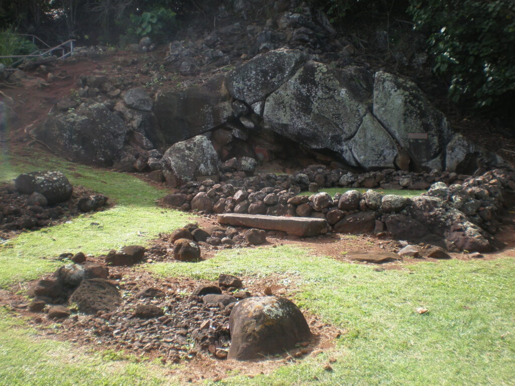
With Kāʻeokūlani, Kamakahelei had a son Kaumualiʻi.  Kaumualiʻi was born at Holoholokū Heiau in Wailua.  (Like its counterpart Kūkaniloko heiau in Wahiawa, Oʻahu, these royal birthing sites maintained the antiquity and purity of the chiefly lineages on O‘ahu and Kauai.  It is said that chiefs from Hawai‘i Island and Maui often sought greater prestige by marrying those with these strong ancestral lineages.)

Her second husband, Kāʻeokūlani, died on Oʻahu in 1794, but the time of her own death has not been remembered, but it probably occurred shortly after that of Kāʻeo.  (Fornander)

At his mother’s death, Kaumualiʻi became the sovereign of Kauai, and, though young in years, appears from all descriptions to have been a prince of remarkable talents and a most amiable temper.  (Fornander)

In the face of the threat of a further invasion, in 1810, at Pākākā on Oʻahu, negotiations between King Kaumuali‘i and Kamehameha I took place and Kaumualiʻi yielded to Kamehameha.  The agreement marked the end of war and thoughts of war across the islands.

© 2022 Hoʻokuleana LLC


Filed Under: Ali'i / Chiefs / Governance Tagged With: Kaeo, Kaumualii, Hawaii, Captain Cook, Holoholoku, Kukaniloko, Kauai, Kahahana, Kahekili, Kalaniopuu, Kamakahelei

December 12, 2016 by Peter T Young Leave a Comment

400 hogs or O‘ahu and Kauai

It’s not clear if the deal was 400-hogs or “the whole right & property of the Islands Woahoo (O‘ahu) & Atooi (Kauai.)”

Whatever the agreement, Kalanikūpule was able to overcome attacks by Kā’eo and held O‘ahu (which he later lost to Kamehameha.)

Let’s look back …

In 1791, Kahekili, King of Oahu, Molokai and Maui, was on Maui with his brother Kāʻeokūlani (Kā‘eo,) King of Kauai, preparing to resist the threatened invasion of Maui by Kamehameha of Hawai‘i. (Cartwright)

Kahekili agreed with Kā’eo that after his death Kā’eo was to be regent of Maui and Molokai while Kalanikūpule, the son and heir of Kahekili, was to be King of Maui, Molokai, and Oahu, but was to reside on O‘ahu and allow Kā’eo to govern Maui and Molokai for him.

Fast forward to 1793 and Captain Brown … he was a British trader, “one of that numerous group of commercial adventurers who flocked into the north Pacific Ocean in the wake of Cook, drawn thither by the chance discovery, as one result of the last expedition led by that great navigator, of the possibilities of wealth in the fur trade between China and the coast of America.” (Kuykendall)

Brown’s three-vessel trading squadron included the ‘Butterworth’ (under Captain Brown,) ‘Prince Lee Boo’ (under Captain Sharp) and the ‘Jackal’ (under the command of Captain Alexander Stewart.)

At Maui Captain Brown seems to have entered into some sort of a politico-commercial agreement with Kahekili. Brown “had left the Isld, only a fortnight before we arrived had given them a number of Muskets, a very large quantity of Powder, and two pieces of Cannon (4 pounders)”. (Boit)

However, for these weapons, Boit says that Kahekili had “given to him the whole right & property of the Islands Woahoo (O‘ahu) & Atooi (Kauai)”. Later, Kamakau notes Kalanikūpule bargained for Brown’s assistance for “four hundred hogs”.

In July 1794, Kahekili died and, according to the prior arrangement, Kalanikūpule took control of O‘ahu and Kā‘eo ruled over Maui and Kauai.

Kā‘eo, who was residing on Maui, decided to return to Kauai. On the way he stopped with a considerable force on the northeast coast of O‘ahu, across the mountains from Waikiki, the capitol of the island.

Some fighting took place between his followers and those of Kalanikūpule, but this trouble was settled by a personal conference between the two chiefs, and Kaeo continued on around the island to Waianae, the usual point of departure for Kauai.

While resting here Kā‘eo learned of a plot among his warriors directed against himself. In this emergency he resorted to a measure not infrequently used by more civilized generals. He proposed an immediate attack on Kalanikūpule and the conquest of O‘ahu.

The plot collapsed and his followers rallied about him with enthusiasm, augmented in numbers by several bands of disaffected Oahuans. The advance toward Waikiki was begun at once and within a few days the two armies were in contact west of Honolulu. (Kuykendall)

Kalanikūpule at once engaged Captain Brown to aid him in this war (in return for four hundred hogs.) A battle was fought on the plains of Puʻunahawele in which some foreigners were killed by Mare Amara. Kalanikūpule was forced to retreat. Six days later, another battle was fought in which Kāʻeo was again victorious.

On December 12, 1794, a great battle was fought; Kalanikūpule himself with the main army held the middle ground between ʻAiea and the taro patches; Captain Brown’s men were in boats guarding the shoreline.

Thus surrounded, Kāʻeo with six of his men escaped into a ravine below ʻAiea and might have disappeared there had not the red of his feather cloak been seen from the boats at sea and their shots drawn the attention of those on land. Hemmed in from above, Kāʻeo was killed. (Kamakau)

After the victory of Kalanikūpule, a victory won by the aid of Captain Brown (and possibly also by the aid of Captain Kendrick (who was also at Honolulu on the Lady Washington,)) a salute was fired from the ships in the harbor.

One of the saluting guns on the Jackal was, through an oversight, loaded with round and grape shot, and this shot passed through the Lady Washington, killing Captain Kendrick and several of his crew.

The body of Kendrick was taken on shore for burial and the natives, who had never seen anything of the kind before, thought the prayer and burial service were “an act of sorcery to procure the death of Captain Brown.” (Kuykendall)

Toward the end of December a plot was formed among the natives for the seizure of the two vessels (Jackal and Prince Lee Boo.) On the first day of January, 1795, the plan was put into execution.

A large number of hogs having been brought to the shore for the ships, the English sailors were employed on the beach salting the pork and preparing it for shipment. Several of the crew with an officer had been sent for salt to a place some distance away.

The Englishmen being thus scattered and the vessels almost deserted, except for the two captains, who remained on board.

“Capt. Brown was walking the poop, by himself, when one of ye Savages gets up on the poop, & made a pass at the Good old Captain with an Iron dagger, which he fend’d of, & seizd a Swivell worm & drove the fellow of, he was soon followed by a number more which the captain likewise beat of …”

“… but at last he was overpower’d by numbers, & receiv’d a fatal stab in the back of the neck and was pitch’d from the poop on to the main deck where he soon expir’d, & so by there savage artfulness they got possession of both Vessells without the loss of a man on there side, in the mean time they had seiz’d the Boats & People that where on shore”. (Boit; Kuykendall)

Being in possession of the two ships, with a large quantity of arms and ammunition, Kalanikupule and his advisers conceived this to be an opportune moment for striking a decisive blow at Kamehameha.

The surviving members of the crews were compelled, under guard, to fit the vessels for sea, and when all was ready the king and his chiefs went on board and the ships were warped out of Fairhaven harbor and anchored in Waikiki bay.

The next day Mr. Bonallack, mate of the Prince Lee Boo, and Mr. Lamport, mate of the Jackal, agreed upon a plan for retaking the vessels that night. It was a desperate venture but the attempt was entirely successful, the natives on board being killed or driven off, with the exception of the king, queen, and three or four of their personal attendants.

The ships immediately put to sea, but at daybreak they again came near the shore and, after placing the king and queen in a canoe with one attendant, made all sail for the island of Hawaii, and from there, after procuring supplies, took their departure for Canton.

Within less than five months after the death of Captain Brown, Kamehameha over-ran Maui and Molokai, defeated Kalanikūpule in the great battle of Nuʻuanu, and became ruler of all the islands except Kauai. (Kuykendall)

Follow Peter T Young on Facebook 

Follow Peter T Young on Google+ 

Follow Peter T Young on LinkedIn  

Follow Peter T Young on Blogger

© 2016 Hoʻokuleana LLC

Dessin_du_Machault_(1791)-Frigate comparable to Butterworth
Sealing_camp,_Cape_Horn,_Jackal_and_Prince_Lee_Boo
Prince_Lee_Boo-_c.1792
Dessin_du_Machault_(1791)-Frigate comparable to Butterworth

Filed Under: General, Ali'i / Chiefs / Governance, Prominent People Tagged With: John Kendrick, Captain Brown, Butterworth, Prince Lee Boo, Jackal, Hawaii, Kamehameha, Kahekili, Kalanikupule, Kaeo

February 12, 2014 by Peter T Young Leave a Comment

Kauai

Poetically the island is reportedly called, “Manōkalanipō”, or “Kauai a Manō” after the ancient chief who was largely responsible for elevating Kauai’s ancient society to sophisticated heights of advancement and productivity.  (NativeKauai)

Geologically, Kauai is the oldest of the main inhabited islands in the chain. It is also the northwestern-most island, with Oʻahu separated by the Kaʻieʻie Channel, which is about 70-miles long. In centuries past, Kauai’s isolation from the other islands kept it safe from outside invasion and unwarranted conflict.

Kauai was traditionally divided into 5 moku (districts) including: Koʻolau, Haleleʻa, Nā Pali, Kona and Puna. (Common district names that are universally used across of the Hawaiian archipelago include “Koʻolau” marking the windward sides of the islands; “Kona” – the leeward sides of the islands; and “Puna” – indicating regions where springs and fresh water abound.)

The whole of the northwest coast (Napali) show the remains of extensive agricultural work and a fairly extensive population; the Mana region had clusters of house sites in the dry valleys that cut through the cliffs. Nearly all the great river valleys are thoroughly terraced and show evidence of population.

The principal location of the house sites is on the shore line, especially near the mouths of the river valleys where the taro was growing; in the mountains are some house sites and small villages.

The principal cultivated products on Kauai were taro, sweet potatoes, yams and gourds among the vegetables, and banana, breadfruit, coconut palm and paper mulberry among the trees.  (Bennett)

Malo notes that the “cultivation of kula lands is quite different from that of irrigable lands. The farmer merely cleared of weeds as much land as he thought would suffice. If he was to plant taro (upland taro), he dug holes and enriched them with a mulch of kukui leaves, ashes or dirt, after which he planted the taro.”

“In some places they simply planted without mulch or fertilizer … If a field of potatoes was desired, the soil was raised into hills, in which the stems were planted; or the stems might merely be thrust into the ground anyhow, and the hilling done after the plants were grown.”

The boundaries of the five moku on Kauai were changed in the late-1800s to reflect the present day judicial land districts, Kawaihau, Hanalei, Waimea, Kōloa and Līhuʻe.

In 1877, Hanalei and Līhuʻe shared a common boundary.  Kawaihau was set apart by King Kalākaua, who gave that name to the property lying between the Wailua River and Moloaʻa Valley.  A bill was introduced into the legislature and the eastern end of Hanalei District was cut out and Kawaihau became the fifth district on the island of Kauai.

Though comprising only 547-square miles, Kauai is large enough to have figured at all times as a major influence on Hawaiian culture. Together with Niʻihau it forms a group which is considerably isolated from the other Hawaiian islands.  (Bennett)

Fornander notes, “the ruling families of Kauai were the highest tapu chiefs in the group is evident from the avidity with which chiefs and chiefesses of the other islands sought alliance with them. They were always considered as the purest of the “blue blood” of the Hawaiian aristocracy; … But of the exploits and transactions of most of the chiefs who ruled over Kauai during this period, there is little preserved to tell.”

He further notes that during the “nine generations from Laamaikahiki (about the 14th century – he reportedly came from Tahiti,) the island of Niihau bore about the same political relation to the mōʻi (king) of Kauai as the island of Lanai did to the mōʻi of Maui – independent at times, acknowledging his suzerainty at others. … Springing from and intimately connected with the Kauai chiefs, there was a community of interests and a political adhesion which, however strained at times by internal troubles, never made default as against external foe.”

Then things changed for Kauai and the rest of the Islands.  In the dawn hours of January 18, 1778, on his third expedition, British explorer Captain James Cook on the HMS Resolution and Captain Charles Clerke of the HMS Discovery first sighted what Cook named the Sandwich Islands (that were later named the Hawaiian Islands.)  He first landed at Waimea, Kauai.

“The height of the land within, the quantity of clouds which we saw, during the whole time we staid, hanging over it, and frequently on the other parts, seems to put it beyond all doubt, that there is a sufficient supply of water; and that there are some running streams which we did not see, especially in the deep valleys, at the entrance of which the villages commonly stand.”  (James Cook Journal)

“From the wooded part to the sea, the ground is covered with an excellent sort of grass, about two feet high, which grows sometimes in tufts, and though not very thick at the place where we were, seemed capable of being converted into plentiful crops of fine hay. But not even a shrub grows naturally on this extensive space.”  (James Cook Journal)

Throughout their stay the ships were plentifully supplied with fresh provisions which were paid for mainly with iron, much of it in the form of long iron daggers made by the ships’ blacksmiths on the pattern of the wooden pāhoa used by the Hawaiians.  The natives were permitted to watch the ships’ blacksmiths at work and from their observations gained information of practical value about the working of iron. (Kuykendall)

After a month’s stay, Cook got under sail again to resume his exploration of the Northern Pacific. Shortly after leaving Hawaiʻi Island, the foremast of the Resolution broke and the ships returned to Kealakekua Bay for repairs.  On February 14, 1779, at Kealakekua Bay, Cook and some of his men were killed.

At the time of Cook’s arrival, the Hawaiian Islands were divided into four kingdoms: (1) the island of Hawaiʻi under the rule of Kalaniʻōpuʻu, who also had possession of the Hāna district of east Maui; (2) Maui (except the Hāna district,) Molokai, Lanai and Kahoʻolawe, ruled by Kahekili; (3) Oʻahu, under the rule of Kahahana; and at (4) Kauai and Niʻihau, Kamakahelei was ruler.

Kamakahelei was the “queen of Kauai and Niʻihau, and her husband (Kāʻeokūlani (Kāʻeo)) was a younger brother to Kahekili, while she was related to the royal family of Hawaiʻi. Thus, it will be seen, the reigning families of the several islands of the group were all related to each other, as well by marriage as by blood. So had it been for many generations. But their wars with each other were none the less vindictive because of their kinship, or attended with less of barbarity in their hours of triumph.”  (Kalākaua)

Kaumuali‘i was the only son of Kamakahelei and Kāʻeo; he was born in 1778 at Holoholokū, a royal birthing heiau specifically designated for the birth of high ranking children.  Kaumuali‘i became ruling chief of Kauai upon the death of his parents.

In 1784, Kamehameha I began a war of conquest, and, by 1795, with his superior use of modern weapons and western advisors, he subdued all other chiefdoms, with the exception of Kauai.  King Kamehameha I launched his first invasion attempt on Kauai in April of 1796, having already conquered the other Hawaiian Islands, and having fought his last major battle at Nuʻuanu on O‘ahu in 1795.

Kauai’s opposing factions (Kaumuali‘i versus Keawe) were extremely vulnerable as they had been weakened by fighting each other (Keawe died and Kaumuali‘i was, ultimately, ruler of Kauai and Ni‘ihau.)  Kamehameha’s two attempts at invading Kauai were foiled (by storm and sickness.)

The island was never conquered; in the face of the threat of a further invasion, in 1810, at Pākākā on Oʻahu, negotiations between King Kaumuali‘i and Kamehameha I took place and Kaumualiʻi yielded to Kamehameha. The agreement marked the end of war and thoughts of war across the islands.

After King Kamehameha I died in 1819, Kaumuali‘i pledged his allegiance to Liholiho, Kamehameha’s son and successor.    Kaumuali‘i settled in Honolulu and became a husband of Kaʻahumanu, widow of Kamehameha I.

Hiram Bingham was on a preaching tour of the island of Kauai in 1824, shortly before King Kaumuali‘i died.  Kaumuali‘i had been living on Oahu for three years.  Bingham spoke to him just before coming to Kauai.

Bingham writes:
“We found Kaumuali‘i seated at his desk, writing a letter of business.  We were forcible and pleasantly struck with the dignity and gravity, courteousness, freedom and affection with which he rose and gave us his hand, his hearty aloha, and friendly parting smile, so much like a cultivated Christian brother.”

When the king died, Bingham said a gloom fell over Kauai.

Kaumuali‘i was buried at Waine‘e Church (Wai‘ola Church,) on Maui (he wanted to be buried near Keōpūolani, another of Kamehameha’s wives – mother of Liholiho (Kamehameha II) and Kauikeaouli (Kamehameha III.))  (King Kaumuali‘i’s granddaughter Kapiʻolani (1834–1899) married King Kalākaua.)

The image shows a map of the island of Kauai, noting moku (districts) and ahupuaʻa. I added a couple of other images in a folder of like name in the Photos section on my Facebook and Google+ pages.

Follow Peter T Young on Facebook  

Follow Peter T Young on Google+  

© 2014 Hoʻokuleana LLC

Filed Under: Ali'i / Chiefs / Governance, Place Names Tagged With: Kamehameha, Kaumualii, Kauai, Koolau, Na Pali, Kaahumanu, Liholiho, Hawaii, Waiola, Kona, Wainee, Kapiolani, Keopuolani, Captain Cook, Kamakahelei, Puna, Kaeo

  • « Previous Page
  • 1
  • 2

Images of Old Hawaiʻi

People, places, and events in Hawaiʻi’s past come alive through text and media in “Images of Old Hawaiʻi.” These posts are informal historic summaries presented for personal, non-commercial, and educational purposes.

Info@Hookuleana.com

Connect with Us

  • Email
  • Facebook
  • LinkedIn
  • Twitter
  • YouTube

Recent Posts

  • Women Warriors
  • Rainbow Plan
  • “Pele’s Grandson”
  • Bahá’í
  • Carriage to Horseless Carriage
  • Fire
  • Ka‘anapali Out Station

Categories

  • Hawaiian Traditions
  • Military
  • Place Names
  • Prominent People
  • Schools
  • Sailing, Shipping & Shipwrecks
  • Economy
  • Voyage of the Thaddeus
  • Mayflower Summaries
  • American Revolution
  • General
  • Ali'i / Chiefs / Governance
  • Buildings
  • Missionaries / Churches / Religious Buildings

Tags

Albatross Al Capone Ane Keohokalole Archibald Campbell Bernice Pauahi Bishop Charles Reed Bishop Downtown Honolulu Eruption Founder's Day George Patton Great Wall of Kuakini Green Sea Turtle Hawaii Hawaii Island Hermes Hilo Holoikauaua Honolulu Isaac Davis James Robinson Kamae Kamaeokalani Kamanawa Kameeiamoku Kamehameha Schools Lalani Village Lava Flow Lelia Byrd Liliuokalani Mao Math Mauna Loa Midway Monk Seal Northwestern Hawaiian Islands Oahu Papahanaumokuakea Marine National Monument Pearl Pualani Mossman Queen Liliuokalani Thomas Jaggar Volcano Waikiki Wake Wisdom

Hoʻokuleana LLC

Hoʻokuleana LLC is a Planning and Consulting firm assisting property owners with Land Use Planning efforts, including Environmental Review, Entitlement Process, Permitting, Community Outreach, etc. We are uniquely positioned to assist you in a variety of needs.

Info@Hookuleana.com

Copyright © 2012-2024 Peter T Young, Hoʻokuleana LLC


Loading Comments...