Images of Old Hawaiʻi

  • Home
  • About
  • Categories
    • Ali’i / Chiefs / Governance
    • American Protestant Mission
    • Buildings
    • Collections
    • Economy
    • Missionaries / Churches / Religious Buildings
    • General
    • Hawaiian Traditions
    • Other Summaries
    • Mayflower Summaries
    • Mayflower Full Summaries
    • Military
    • Place Names
    • Prominent People
    • Schools
    • Sailing, Shipping & Shipwrecks
    • Voyage of the Thaddeus
  • Collections
  • Contact
  • Follow

March 8, 2023 by Peter T Young Leave a Comment

Naha Stone

The legend of King Arthur (Le Morte Darthur, Middle French for “the Death of Arthur” (published in 1485)) speaks of King Arthur, Guinevere, Lancelot and the Knights of the Round Table (and foresees “Whoso pulleth out this sword of this stone is the rightwise born king of all England.”)

Many tried; many failed.

Legendary Arthur later became the king of England when he removes the fated sword from the stone. Legendary Arthur goes on to win many battles due to his military prowess and Merlin’s counsel; he then consolidates his kingdom.  (The historical basis for the King Arthur legend has long been debated by scholars.)

In Hawaiʻi, a couple legends and prophecies relate to a stone, Naha Pōhaku (the Naha Stone.)

Its weight is estimated to be two and one-half tons (5,000-pounds.)  The stone was originally located in the Wailua River, Kauai; it was brought to Hilo by chief Makaliʻinuikualawaiea on his double canoe and placed in front of Pinao Heiau.  (NPS)

The stone was reportedly endowed with great powers and had the peculiar property of being able to determine the legitimacy of all who claimed to be of the royal blood of the Naha rank (the product of half-blood sibling unions.)

As soon as a boy of Naha stock was born, he was brought to the Naha Stone and was laid upon it – one faint cry would bring him shame.  However, if the infant had the virtue of silence, he would be declared by the kahuna to be of true Naha descent, a royal prince by right and destined to become a brave and fearless soldier and a leader of his fellow men.  (NPS)

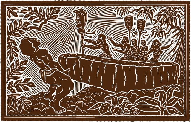
In another instance, Kamehameha traveled from Kohala to Hilo with Kalaniwahine a prophetess, who advised him that there was a deed he must do.  Although not of Naha lineage, Kamehameha came to conquer the Naha Stone.

Kalaniwahine proclaimed that if he succeeded in moving Naha Pōhaku, that he would move the whole group of Islands. If he changed the foundations of Naha Pōhaku from its resting place, he would conquer the whole group and he would prosper and his people would prosper.

Kamehameha said, “He Naha oe, a he Naha hoi kou mea e neeu ai. He Niau-pio hoi wau, ao ka Niau-pio hoi o ka Wao.” (”You are a Naha, and it will be a Naha who will move you. I am a Niaupio, the Niaupio of the Forest.”)

With these words did Kamehameha put his shoulders up to the Naha Stone, and flipped it over, being this was a stone that could not be moved by five men.  (Hoku o Hawaiʻi, November 1, 1927)

When Kamehameha gripped the stone and leaned over it, he leaned, great strength came into him, and he struggled yet more fiercely, so that the blood burst from his eyes and from the tips of his fingers, and the earth trembled with the might of his struggling, so that they who stood by believed that an earthquake came to his assistance.  (NPS)

The stone moved and he raised it on its side.

And, the rest of the history of the Islands has been pretty clear about the fulfillment of the prophecy and unification of the Islands under Kamehameha.

The Naha Stone is in front of Hilo Public Library at 300 Waiānuenue Avenue between Ululani and Kapiʻolani Street (the larger of the two stones there.)

The upright stone sitting to the makai side of the Naha Stone is associated with the Pinao Heiau, one of several that once stood in Hilo. Some of the stones that built the first Saint Joseph church and other early stone buildings in town likely came from Pinao heiau.  (Zane)

© 2023 Hoʻokuleana LLC

Filed Under: Ali'i / Chiefs / Governance, Hawaiian Traditions Tagged With: Kamehameha, Pinao Heiau, Naha Stone, Hawaii, Hawaii Island, Hilo

March 7, 2023 by Peter T Young Leave a Comment

Kumukahi

Mai ka hikina a ka Ia i
Kumukahi a ka welona a ka Iā i Lehua.

From the sunrise at Kumukahi to
the fading sunlight at Lehua.

From sunrise to sunset. Kumukahi, in Puna, Hawai‘i, was called the land of the sunrise and Lehua, the land of the sunset. This saying also refers to a life span-from birth to death.  (Pukui, #258)

Kumukahi is a place of importance and a place of healing. Practitioners of la‘au lapa‘au often prayed to Kumukahi and his brother Palamoa as “deities of healing” when gathering and applying traditional Hawaiian herbal medicine. These practitioners would face the Hikina (East) and chant their prayers at sunrise from where ever they were living in the islands. (Lopes)

Kumukahi is translated as the ‘beginning/first source, chief, or teacher,’ in reference to the “first source” of wisdom, knowledge or of knowing.

This is because of its location in relation to the sun, Kānehoalani (an akua who is, in one story, Pele’s father) and what the sun represents, as the easternmost point of Hawaiʻi.

It is the beginning of our collective consciousness as people of Hawaiʻi, which establishes Kumukahi as a wahi pana (living and celebrated place) and a wahi moʻolelo (a storied place). (Hawai‘i County)

Kumukahi was also noted as a “leina a ka uhane,” a place where the soul of a person would leap from this world into the next after death. (Lopes)

Kumukahi was named for a migratory hero from Kahiki (Tahiti) who stopped here and who is represented by a red stone. Two of his wives, also in the form of stones, manipulated the seasons by pushing the sun back and forth between them. One of the wives was named Ha‘eha‘e. Sun worshipers brought their sick to be healed here. (Pukui)

In some accounts, Kumukahi is a kolea bird and is referred to as “the messenger of the gods.” According to Pukui, Kumukahi was the name of a “kanaka aiwaiwa,” a divine being who loved sports, especially holua sledding.

For this reason Pele, the akua wahine of the volcano, was fond of him. Kumukahi often produced sporting events in which his people participated. Pele often joined in on these particular festivities in the form of an attractive woman.

However, on one such occasion, Pele, disguised as an old woman, requested to participate and was denied. In her anger, she chased Kumukahi to the sea where she covered him with her lava. (Lopes)

At the tip of Cape Kumukahi were a number of stone cairns, built of the rough lava from the surrounding flow, which are said to have been built by the various monarchs of the Hawaiian kingdom upon assuming the throne. Some reference them as Ki‘i Pōhaku Ali‘i – King’s Pillars.

In 1823, William Ellis and members of the ABCFM toured the island of Hawai‘i seeking out community centers in which to establish church centers for the growing Protestant mission.

Settlement patterns in Puna tend to be dispersed and without major population centers. Villages in Puna tended to be spread out over larger areas and often are inland, and away from the coast, where the soil is better for agriculture.  (Escott)

This was confirmed on William Ellis’ travel around the island in the early 1800s, “Hitherto we had travelled close to the sea-shore, in order to visit the most populous villages in the districts through which we had passed.”

“But here receiving information that we should find more inhabitants a few miles inland, than nearer the sea, we thought it best to direct our course towards the mountains.”  (Ellis, 1823)

Ellis noted, “The population of this part of Puna, though somewhat numerous, did not appear to possess the means of subsistence in any great variety or abundance; and we have often been surprised to find the desolate coasts more thickly inhabited than some of the fertile tracts in the interior …”

“… a circumstance we can only account for, by supposing that the facilities which the former afford for fishing, induce the natives to prefer them as places of abode; for they find that where the coast is low, the adjacent water is generally shallow.”

When the Lighthouse Board assumed control of Hawai‘i’s lighthouses in 1904, it began work on a plan to erect major lights to better mark approaches to the islands. Funds for Makapu‘u Lighthouse were secured in 1906, money for Molokai lighthouse was obtained in 1907, and Congress made an appropriation for Kilauea Point Lighthouse in 1908.

These aids to navigation were seen as “material benefit to the business .community, to shipping interests, insurance interests and mercantile interests. … [T]he next one we have recommended is for a first order light at Cape Kumukahi, the easternmost point on the Island of Hawaii.”  (PCA, Nov 4, 1908)

“There is at present no landfall light for vessels bound to Hawaii by way of Cape Horn. Several vessels have within recent years gone ashore on Kumukahi Point. This is the first land sighted by vessels from the southward and eastward.”

“The shipping from these directions now merits consideration, and with the improvement of business at Hilo the necessity for a landfall light on this cape grows more urgent. It is estimated that a light at this point can be established for not exceeding $75,000, and the Board recommends that an appropriation of this amount be made therefor.” (Report of the Lighthouse Board, 1908)

On December 31, 1928, the US government purchased fifty-eight acres on Cape Kumukahi from the Hawaiian Trust Company for the sum of $500. During the following year, a thirty-two-foot wooden tower capped with an automatic acetylene gas light was built at the cape for local use.  It was replaced in 1933 by a 125-foot pyramidical galvanized steel tower. (Lighthouse Friends)

“Life was peaceful for several years along the Puna coastline until a lava flow threatened Kapoho in 1955. [Kumukahi lightkeeper Joe] Pestrella stayed at his post to watch over the lighthouse as the lava advanced.” 

“The following year, he received the “Civil Servant of the Year” award from the U.S. Coast Guard for his bravery in staying at his post. At the time, Ludwig Wedemeyer, leader of the Hilo Coast Guard station, noted it was the first time a Hawai‘i Island resident had received such an award from the Coast Guard.” (Laitinen)

On January 12, 1960, over 1,000 earthquakes were recorded near Kapoho Village, just above Kumukahi. The earthquakes grew in size and frequency, creating large fractures along the Kapoho Fault overnight.  The 1960 Kīlauea eruption began on the night of January 13.

For the first two weeks, Kapoho village remained virtually intact except for a blanket of pumice and ash that covered everything. The lava flow issuing from the growing cinder cone was moving in the opposite direction of town.

Things changed on January 27th when very fluid lava poured from the vents and fed massive ‘a‘ā flows that moved southwestward through the streets of town. By midnight, most of Kapoho had been destroyed.

By January 28, lava destroyed Coast Guard residences near Cape Kumukahi, but the lighthouse was spared. The Koa‘e Village fell victim to lava flow progression, losing the community hall, a local church and one residence.  The eruption stopped February 19. (USGS)

“After the 1960 eruption ended, an electric line was run from Kapoho Beach Lots to the lighthouse to restore power, and the light became automated. Joe was transferred to a lighthouse on O‘ahu, and when he retired in 1963, he was the last civilian lighthouse keeper in Hawai‘i.”  (Laitinen)

With prevailing NW trade winds and nothing between it and the America continents, except thousands of miles of open ocean, Kumukahi has some of the cleanest air in the Northern Hemisphere.

The Kumukahi light tower is also used as a monitoring station to test air quality. Since 1993, scientists have been taking ambient air samples every week for chemical analysis.

The long-term data records supplied by these samples are fundamental to understanding changes in atmospheric composition of gases affecting stratospheric ozone, climate and air quality, and provide an avenue to detect unexpected changes in these chemicals.

The 2018 eruptions interrupted the sampling efforts and NOAA scientists have undertaken novel development of an uncrewed aircraft system (UAS) “hexacopter” that will enable the lab to not only recommence a long-standing mission that was recently forced to halt, but paves the way toward enhanced operations in the future.  (NOAA)

© 2023 Ho‘okuleana LLC

Filed Under: Economy, Hawaiian Traditions, Place Names Tagged With: Kumukahi, Hawaii, Hawaii Island, Cape Kumukahi

March 6, 2023 by Peter T Young Leave a Comment

Six Main Styles of Hawaiian Fishponds

A fishpond symbolized a rich ahupua‘a (major land division), which reflected favorably on the ali‘i as well as on the people living in the ahupua‘a.

There are two general types of fishponds, saltwater and freshwater, with six main styles. The style of fishponds constructed is closely related to the topographical features of an area.

The salinity of the water served as an important element determining type of construction as well as what types of food that could be raised and their level of productivity.

The six main styles of fishponds as identified by Kikuchi include: Loko Kuapā, Loko Pu‘uone, Loko Wai, Loko I‘a Kalo, Loko ‘Ume‘iki and Kāheka / Hāpunapuna.

The first three types of coastal fishponds – Loko Kuapā, Loko Pu‘uone, and Loko Wai – belonged to royalty. These ponds, between 10 and 100 acres in size, were considered a symbol of high social and economic status.

Loko Kuapā

A fishpond of littoral water whose side or sides facing the sea consist of a stone or coral wall usually containing one or more sluice grates.

Loko kuapā (Figure 1, Type 1) were strictly coastal fishponds whose characteristic feature was a kuapā (seawall) of lava or coral rubble. They were usually built over a reef flat, with the wall extending out from two points on the coast in an enclosed semicircle.

These ponds usually had one or two ‘auwai (channels) that were used mainly for water flushing or inflow, depending on the rising and ebbing of the tides, but were also used during harvesting and stocking.

Loko kuapā, because they were enclosed reef flats, had all the marine aquatic sea life that would be expected to be found on a reef flat including kala, palani, and manini.

Less common fish sometimes found in these fishponds were the kāhala, kumu, moano, weke ula, uhu, various species of hīnālea, surgeonfish, crevally, goatfish, and even puhi.

Loko Pu‘uone

An isolated shore fishpond usually formed by the development of barrier beaches building a single, elongated sand ridge parallel to the coast and containing one or more ditches and sluice grates.

Loko pu‘uone contained mostly brackish water, with inputs from both freshwater and saltwater sources.  Fresh water from streams, artesian springs, and percolation from adjacent aquifers was mixed with seawater that entered through channels during incoming tides.

This mixing produced a highly productive estuarine environment. The most characteristic feature of this type of fishpond was a sandbar, coastal reef structure, or two close edges of landmass that could be connected to enclose a body of water.

Typical of these ponds were fish that were able to handle fluctuations of salinity. These fish include ‘ama‘ama, awa, āholehole, pāpio or ulua, ‘ō‘io, nehu, awa ‘aua, ‘o‘opu, kaku, moi, and weke.

Loko Wai

An inland freshwater fishpond which is usually either a natural lake or swamp, which can contain ditches connected to a river, stream, or the sea, and which can contain sluice grates.

It was typically made from a natural depression, lake, or pool whose water was mainly from diverted streams, natural groundwater springs, or percolation from an aquifer. Various ‘o‘opu were commonly found in these ponds.

Loko I‘a Kalo

An inland fishpond utilizing irrigated taro plots.  These “kalo fishponds” combined aquaculture with flooded agriculture. Kalo lo‘i were used to raise ‘o‘opu, ‘ama‘ama, and āholehole.

Research has suggested that diversion of stream runoff for the irrigation of kalo eventually led to fish aquaculture. Irrigated agriculture in lo‘i was enhanced by including fish (loko i‘a kalo), and this led to pure fishpond aquaculture  – loko pu‘uone.

Loko ‘Ume‘iki

Loko ‘ume iki were not actually fishponds but rather fish traps. Like the loko kuapā, they were constructed on a reef flat, but loko ‘ume iki had “fish lanes,” corridors used to net or trap fish going onto or off the reef.

Each loko ‘ume iki had many fish lanes with fishing rights usually assigned to a family. The traps operated without the use of gates and relied on natural movements of fish.

The lanes were usually tapered, with the wide end facing either inward or outward, and anywhere from 10 to 40 feet long.

Kāheka and Hāpunapuna

A natural pool or holding pond.  These fishponds are also referred to as anchialine ponds. They have no surface connection to the sea, contain brackish water and show tidal rhythms. Many have naturally occurring shrimp and mollusks.

Most Hawaiian anchialine ponds are in the youngest lava areas of the Big Island of Hawaiʻi and Maui. They exist in inland lava depressions near the shore and contain brackish (a mixture of freshwater and saltwater) water.

Freshwater is fed to the ponds from ground water that moves downslope and from rainwater. Ocean water seeps into the ponds through underground crevices in the surrounding lava rock.  (Lots of information here is from DLNR and Farber.)

© 2023 Ho‘okuleana LLC

Filed Under: Ali'i / Chiefs / Governance, Hawaiian Traditions Tagged With: Loko Wai, Loko Ia Kalo, Loko Umeiki, Kaheka, Hapunapuna, Hawaii, Fishpond, Loko Puuone, Loko Kuapa

February 19, 2023 by Peter T Young Leave a Comment

1871 Trail & Alahaka Ramp

“We walked a mile over a raised macadamized road of uniform width; a road paved with flat stones and exhibiting in its every detail a considerable degree of engineering skill.”

“The stones are worn and smooth, and pushed apart in places, so that the road has the exact appearance of those ancient paved highways leading out of Rome which one sees in pictures.” (Mark Twain, Sacramento Daily Union, September 22, 1866)

Although the canoe was a principal means of travel in ancient Hawai`i, extensive cross-country trail networks enabled gathering of food and water and harvesting of materials for shelter, clothing, medicine, religious observances and other necessities for survival.

Ancient trails, those developed before western contact in 1778, facilitated trading between upland and coastal villages and communications between ahupua‘a and extended families.

These trails were usually narrow, following the topography of the land. Sometimes, over ‘a‘ā lava, they were paved with water-worn stones.

Alahele (trails) and alaloa (regional thoroughfares) were an integral part of the cultural landscape of South Kona and all Hawai‘i. The alahele provided access for local and regional travel, subsistence activities, cultural and religious purposes, and for communication between extended families and communities. Trails were important features of the cultural landscape.

Historical accounts describe at least two primary trails of regional importance in the South Kona region. One trail crossed the makai (near shore) lands, linking coastal communities and resources together. The other major trail of this region is “Kealaʻehu” (The path of Ehu), which passes through the uplands (in the vicinity of the Mamalahoa Highway.) (Rechtman)

Until the 1840s, overland travel was predominantly by foot and followed the traditional trails. By the 1840s, the use of introduced horses, mules and bullocks for transportation was increasing, and many traditional trails – the ala loa and mauka-makai trails within ahupua‘a – were modified by removing the smooth stepping stones that caused the animals to slip.

Eventually, wider, straighter trails were constructed to accommodate horse drawn carts. Unlike the earlier trails, these later trails could not conform to the natural, sometimes steep, terrain.

It was probably Kuakini, Governor of Hawaiʻi Island from 1819 to 1844, who was very aggressive in building roads with prison labor and took the initiative in modifying trails for horse travel. This often involved throwing out the steppingstones and adding curbstones. (Curbstones enabled animals to follow a path without the rider’s constant guidance.) (NPS)

They often by-passed the traditional trails as more remote coastal villages became depopulated due to introduced diseases and the changing economic and social systems.

By the early-1850s, specific criteria were developed for realigning trails and roadways, including the straightening of alignments and development of causeways and bridges.

“The history of road making in this kingdom does not date far back. The first law that we find recorded was enacted in 1840, which as well as the laws of 1846 and 1850 gave to the Governors a general control of the roads, with power to make new roads and employ prisoners in their construction.”

“But no system of road making has ever been introduced, and the whole subject has been left to be executed as chance dictated. In 1852 road supervisors were made elective by the people, at the annual election in January. This change worked no improvement in the roads, as the road supervisors, in order to remain popular, required the least possible amount of labor, and in many districts an hour or two of work in the morning was considered as a compliance with the road law.”

“Under this law the road supervisors were pretty much to themselves, and though accountable to the Minister of the Interior, they considered favor of their constituents of more importance. This law was found productive of more evil than good, and during the last session of the legislature a new road law was passed, which goes in to force on the 1st of January 1857.”

“This new law gives to the Minister of the Interior the appointment of road supervisors throughout the Kingdom, who are subject to such general instructions (we suppose in regard to the construction of roads) as he may issue.” (Pacific Commercial Advertiser, September 25, 1856)

In 1871, a coastal trail that originally extended from Napoʻopoʻo south to Hoʻokena was repaired, and renamed the 1871 Trail. It is a section of the historic coastal Alaloa (regional trail) and was a primary route of travel between communities, royal centers, religious sites and resources. (It was improved as a ‘two-horse trail’ because it was widened to accommodate two horses.)

The Alahaka Ramp, located near the southern end of the Keanaeʻe Cliffs, is a massive stone ramp that ascends the pali from Keokea into Kiʻilae and connects the 1871 trail to Kiʻilae Village.

It is during this time that a series of large-scale government programs were initiated that focused on improvements to public resources, such as roadways.

It is one of the significant road construction events of this period. Prior to the construction of the ramp, folks used a ladder or rope to get up the slope. Alahaka ramp was built to allow horses to continue on the trail.

The 1871 Trail was used as part of a trade route in Hawaii. Having horses meant that people were able to transport more goods to trade, so it was very important that horses could navigate the trail.

In regards to the Alahaka Ramp, the first reference of a ‘constructed ramp’ is found in a letter to the Minister of the Interior dated February 4, 1868. In this letter, George Hardy, the road supervisor at the time, said:

“In South Kona, I have repaired (a very) bad place known by the name of Alahaka in the village of Kiʻilae, a place of great danger where several horses had been kill’d: and where people were in danger of going up and down. I have made it wide and a substantial road.” (NPS)

As noted in a December 31, 1897 letter, the Alahaka Ramp had fallen into a state of disrepair, when road supervisor TH Wright wrote: “Napoʻopoʻo to Hoʻokena beach road in a fearful condition, it needs repair of the worst kind. The Walahaka pali is very dangerous. This road is used every day for the convenience of the public, going and back to these places.” (NPS)

Wheeled vehicles did not enter Honaunau until 1918; travel in that area continuing to be by horses, mules and donkeys, as well as by foot. Although the area remained somewhat isolated due to the lack of a cart road, better trails continued to be built for mounted traffic.

In 1918 the trail section north of Honaunau was improved for wheeled traffic; however, the section south to Hoʻokena was never modified for motorized vehicles.

In 1951, a large earthquake caused an upper section of the ramp to slough off, which over the next ten years, continued to deteriorate. Twelve years later, the newly established National Park, conducted a rebuilding the entire makai (ocean-facing) side with steel rebar, mortar and stones.

A portion of the 1871 Trail, as well as the Alahaka Ramp are situated within the Puʻuhonua O Honaunau National Historical Park and is available to hike – from Honaunau to Hoʻokena. Two trailheads: at the National Historical Park or Hoʻokena Beach Park. (Round trip is about 6.5-miles.)

© 2022 Hoʻokuleana LLC

1871_Trail-Alahaka_Ramp-NPS
1871 Trail looking north toward the Pu'uhonua, Keanae'e Cliffs to the right
1871 Trail looking north toward the Pu’uhonua, Keanae’e Cliffs to the right
Alahaka Ramp-1871_trail
Alahaka Ramp
Alahaka Ramp
Alahaka Ramp
Alahaka Ramp
1871 Trail
1871 Trail
1871 Trail
1871 Trail
Alahaka Ramp
Alahaka Ramp
Alahaka Ramp
Alahaka Ramp
1871 Trail in 1963
1871 Trail in 1963
NPS Masons stabilize the Alahaka Ramp
Masons repair the Alahaka Ramp-1963
Petrified Niagara
Petrified Niagara
Honaunau_Section_Reg1445-1888
Honaunau_Section_Reg1796-1896
Keei_2-Honaunau-Reg1457

Filed Under: Hawaiian Traditions, Place Names Tagged With: Hawaii, Kona, Puuhonua O Honaunau, Puuhonua O Honaunau National Historical Park, 1871 Trail, Alahaka Ramp

February 18, 2023 by Peter T Young Leave a Comment

Kuāuna

According the research and reporting by noted archaeologists, there were three main technological advances resulting in food production intensification in pre-contact Hawai‘i: (a) walled fishponds, (b) terraced pondfields with their irrigation systems and (c) systematic dry-land field cultivation organized by vegetation zones.

The lo‘i kalo (terraced pondfields), a technological invention by Hawaiian Polynesians, was the development of their extended stone-faced, terraced pondfields (lo‘i) and their accompanying irrigation systems (‘auwai) for the intensive cultivation of wetland taro (kalo.)

“The ground within the lo‘i [was] broken by means of a mattock or ‘ō‘ō. ‘Ō‘ō designates the tool largely used by the natives in cultivation in preference to the implements of modern farmers.”

“The ‘ō‘ō closely resembles in its manner of use the sharpened stick of kauila or other hard wood, used by them previous to their knowledge of iron.  The first metal ‘ō‘ō were blubber spades brought here by the whaling-vessels.”

“The boundaries of a lo‘i depend largely upon the shapes of adjacent lo‘i, and upon the relative positions of the various levels along which the irrigation water is to run.”

“The embankments of the lo‘i are built up of stones and clods of earth. These embankments were commonly known as kuāuna. … Names less frequently used, for the embankments of the lo’i, were ika, kaika and kuaio.”

“In former times the kuāuna between the lo‘i was much wider than at present. They served as a convenient place on which to throw the grass and weeds pulled up from the lo’i until they were wanted as fertilizer.”

“Often sugar-cane, banana plants, or the ki plant, grew luxuriantly on these kuāuna. As kalo land increased in value the kuāuna naturally shrunk in width, and with the advent of the Chinese planter they were often made too narrow to walk upon dry shod. Ho‘ohu meant to run along the bank of a kalo patch.”

“The side or border of an upland kalo field was called iwi. Iwi means a bone, a name applied to the long rows of stones gathered from the mo‘o ‘āina or to a narrow strip of upland to be planted with kalo or potatoes.”

“These iwi always run in the direction of the slope from the sea towards the mountains. As they coincide with the division lines between the fields, the term iwi ‘āina came to mean the boundaries between such lands, and is a term often used in that sense in the descriptions in the Hawaiian language on record in the Land Office.”

“If necessary considerable soil is taken from the lo‘i and put upon the embankments so that the surface of the lo’i will be below the level of the water supply. La‘ola‘o la‘au were the little sticks put down to sustain the kuāuna or bank of the kalo patch.”

“Water is then turned in and is soon soaked up by the broken soil. While the ground is still wet it is dug up or plowed several times. The Hawaiians call this labor mahi-ai. (The Hawaiian Forester and Agriculturist, Volume 11, 1914)

The terraces were irrigated with water brought in ditches (‘auwai) from springs and streams high in the valleys, allowing extensive areas of the valleys to be cultivated.

The irrigation ditches and pondfields were engineered to allow the cool water to circulate among the taro plants and from terrace to terrace, avoiding stagnation and overheating by the sun (which would rot the taro tubers).

An acre of irrigated pondfields produced as much as five times the amount of taro as an acre of dryland cultivation. Over a period of several years, irrigated pondfields could be as much as 10 or 15 times more productive than unirrigated taro gardens, as dryland gardens need to lie fallow for greater lengths of time than irrigated gardens.

In addition, walled pondfields not only produce taro, but were also used to raise an additional source of food, freshwater fish (primarily the Hawaiian goby (‘o‘opu nakea) and certain kinds of shrimp (‘opae)).

Captain George Vancouver visited O‘ahu in 1792 and wrote about the taro gardens in tine Waikīkī-Kapahulu-Mo‘ili‘ili-Manana complex that he observed:

“Our guides led us to the northward through the village [Waikīkī], to an exceedingly well-made causeway, about twelve feet broad, with a ditch on each side.”

“This opened to our view a spacious plain … the major part appeared divided into fields of irregular shape and figure, which were separated from each other by low stone walls, and were in a very high state of cultivation.”

In 1815, the explorer Kotzebue added to these descriptions by writing about the gardens and the artificial ponds that were scattered throughout the area:

“The luxuriant taro-fields, which might be properly called taro-lake, attracted my attention.  Each of these consisted of about one hundred and sixty square feet, forms a regular square, and walled round with stones, like our basins.”

“This field or tank contained two feet of water, in whose slimy bottom the taro was planted, as it only grows in moist places. Each had two sluices. One to receive, and the other to let out, the water into the next field, whence it was carried farther.”

© 2023 Ho‘okuleana LLC

Filed Under: Hawaiian Traditions Tagged With: Loi, Kalo, Pondfield, Kuauna

  • « Previous Page
  • 1
  • …
  • 32
  • 33
  • 34
  • 35
  • 36
  • …
  • 100
  • Next Page »

Images of Old Hawaiʻi

People, places, and events in Hawaiʻi’s past come alive through text and media in “Images of Old Hawaiʻi.” These posts are informal historic summaries presented for personal, non-commercial, and educational purposes.

Info@Hookuleana.com

Connect with Us

  • Email
  • Facebook
  • LinkedIn
  • Twitter
  • YouTube

Recent Posts

  • Four Horsemen
  • Prince Jonah Kūhiō Kalanianaʻole Piʻikoi
  • Tutasi
  • Lurline
  • About 250 Years Ago … ‘Give Me Liberty, Or Give Me Death’
  • About 250 Years Ago … Stamp Act
  • Telling Time

Categories

  • General
  • Ali'i / Chiefs / Governance
  • Buildings
  • Missionaries / Churches / Religious Buildings
  • Hawaiian Traditions
  • Military
  • Place Names
  • Prominent People
  • Schools
  • Sailing, Shipping & Shipwrecks
  • Economy
  • Voyage of the Thaddeus
  • Mayflower Summaries
  • American Revolution

Tags

Albatross Al Capone Ane Keohokalole Archibald Campbell Bernice Pauahi Bishop Charles Reed Bishop Downtown Honolulu Eruption Founder's Day George Patton Great Wall of Kuakini Green Sea Turtle Hawaii Hawaii Island Hermes Hilo Holoikauaua Honolulu Isaac Davis James Robinson Kamae Kamaeokalani Kameeiamoku Kamehameha Schools Lalani Village Lava Flow Lelia Byrd Liberty Ship Liliuokalani Mao Math Mauna Loa Midway Monk Seal Northwestern Hawaiian Islands Oahu Papahanaumokuakea Marine National Monument Pearl Pualani Mossman Quartette Thomas Jaggar Volcano Waikiki Wake Wisdom

Hoʻokuleana LLC

Hoʻokuleana LLC is a Planning and Consulting firm assisting property owners with Land Use Planning efforts, including Environmental Review, Entitlement Process, Permitting, Community Outreach, etc. We are uniquely positioned to assist you in a variety of needs.

Info@Hookuleana.com

Copyright © 2012-2024 Peter T Young, Hoʻokuleana LLC


Loading Comments...