Images of Old Hawaiʻi

  • Home
  • About
  • Categories
    • Ali’i / Chiefs / Governance
    • American Protestant Mission
    • Buildings
    • Collections
    • Economy
    • Missionaries / Churches / Religious Buildings
    • General
    • Hawaiian Traditions
    • Other Summaries
    • Mayflower Summaries
    • Mayflower Full Summaries
    • Military
    • Place Names
    • Prominent People
    • Schools
    • Sailing, Shipping & Shipwrecks
    • Voyage of the Thaddeus
  • Collections
  • Contact
  • Follow

April 20, 2022 by Peter T Young Leave a Comment

John (Johnny) Henry Wilson

His story starts in 1820, when his great grandfather, Andrew Henri Blanchard (captain of the brig Thaddeus that brought the first company of Protestant missionaries to Hawaiʻi) married Koloa, a Molokaʻi chiefess.

Fast forward a couple generations and John “Johnny” Henry Wilson was born December 15, 1871 to Charles Burnett (CB) Wilson and Eveline (Townsend) Wilson.

His parents’ friends included the John and Lydia Dominus and Kalākaua.  “We had known Mr. Wilson quite well as a young man when he was courting his wife. My husband and myself had warmly favored his suit; and, with his wife, he naturally became a retainer of the household, and from time to time they took up their residence with us.”  (Liliʻuokalani)

During her imprisonment, Queen Liliʻuokalani was denied any visitors other than one lady in waiting (Mrs. Eveline Wilson – Johnny’s mother.)  Johnny would bring newspapers hidden in flowers from the Queen’s garden; reportedly, Liliʻuokalani’s famous song Kuʻu Pua I Paoakalani (written while imprisoned,) was dedicated to him (it speaks of the flowers at her Waikiki home, Paoakalani.).

Johnny Wilson attended Fort Street School and St. Alban’s College (forerunners to the present McKinley and ʻIolani High Schools.)

He had a short stint working for Dillingham’s Oʻahu Railway and Land Company – there he had interest in being a civil engineer.  In 1891, with financial support from Liliʻuokalani, Wilson was in the first class of Stanford University – there, he was known as “Kanaka” Wilson.

Back in Hawaiʻi, in 1897, Johnny and fellow Stanford student Louis Whitehouse won the bid to expand and construct a ‘carriage road’ over the Pali.  Ground was broken on May 26, 1897 and the road was opened for carriages on January 19, 1898.  (Later, the Pali tunnels were completed and the old road abandoned – on August 1, 1961, Mrs. Jennie Wilson (his wife) led the dedication ceremonies.)

Wilson and Whitehouse also won the contract to extend Benjamin Dillingham’s railroad around Kaʻena Point.  To keep the bid low, they carried laborers, equipment and supplies to the site and freight back by boat – on October 14, 1897, the place where the first Japanese laborers landed for this job is known to this day as “Yokohama Beach.”  (ascehawaii)
He and his wife, Jennie “Kini” Kapahu (previously a court dancer) toured the continent in 1900 with their Hawaiian Village hula troupe.  (Kini Kapahu claimed that she was the ‘first girl to leave Hawai‘i to go as a dancer in the mainland’.)

Wilson got involved with politics and is credited as being the most important Democrat in the first half of 20th-century Hawaiʻi; his name is used with Jack Burns in the party movement.  He was in a meeting on April 30, 1900 that organized the Democratic Party of Hawaiʻi.

His initial political campaign in 1918 met with failure.  Mayor Joe Fern, Honolulu’s first Mayor, appointed his good friend Wilson as road supervisor for the Honolulu district.  Later, Wilson succeeded Fern as Mayor, following the illness and death of Fern.

Fern died on February 20, 1920; the Honolulu Board of Supervisors voted in Wilson on February 25, and he was sworn in as Mayor on February 29.  He would serve three stints as mayor: 1920 to 1927, 1929 to 1931 and 1946 to 1954.  (From 1941 to 1946, he was Director of Public Works.)

Honolulu Hale was an idea started by Joseph J Fern, but he died before it came to fruition.  Mayor Wilson carried on Fern’s dream; Honolulu Hale was finally completed in 1928.

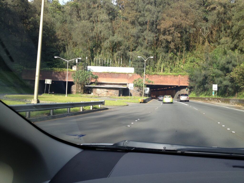
Wilson foresaw the growth on the windward side and excavation commenced on January 8, 1954 on the “Kalihi Tunnel.”  Near the end of May 1954 tunnel excavation transitioned from rock to “earth” – in the summer of 1954, several tunnel collapses and surface sinkholes subsequently led to a large collapse on August 14 that killed five construction workers.

Construction ceased while they considered alternative methods of completion.  Tunnel excavation restarted in February 1956 and the first half-mile tunnel was open to two-way traffic in 1958; both tunnels were fully operational by November 1960.

Initially known as the ‘Kalihi Tunnel,’ and often called the Likelike Tunnels, they are named in honor of John H Wilson.  (1998 brought the completion of H-3 (and the Tetsuo Harano Tunnels – named after a longtime state highways administrator.))

In addition to the John H Wilson Tunnels, the John H Wilson Elementary School on Kilauea Avenue and the adjoining Wilson Playground at Papakōlea in Waiʻalae Nui Valley are named for Wilson.

Johnny Wilson passed away on July 2, 1956 at the age of 84.

© 2022 Hoʻokuleana LLC

Filed Under: Prominent People Tagged With: Honolulu, Oahu, Liliuokalani, Pali, Wilson Tunnel, Johnny Wilson, Yokohama, Joe Fern, Likelike Highway, Hawaii, Paoakalani, Waikiki

April 15, 2022 by Peter T Young Leave a Comment

Hāpuʻu and Kalaʻihauola


Hiʻiaka, looking towards the uplands, where she saw Hāpuʻu and Kalaʻihauola – “I do not want you to say I did not acknowledge you, so here are the chanted regards from the traveler.” Then Hiʻiaka offered up this kanaenae (chant of praise.)

O Hāpuʻu and Kalaʻihauola
O women who dwell on the Koʻolau range
Residing upon the pathway
I offer this chant for those who pass that way.

Hāpuʻu and Kalaʻihauola were supernatural grandmothers of Piʻikea, wife of ʻUmi-a-Līloa.  They wanted to have a grandchild to take back to Oʻahu to raise, because the mother of Piʻikea, Laieloheloheikawai, belonged to Oʻahu. (Laieloheloheikawai sent Hāpuʻu and Kalaʻihauola to the Island of Hawaiʻi to bring back one of Piʻikea’s children.)  ʻUmi refused.

Then, people in the village started to die at night; the supernatural personages of Hāpuʻu and Kalaʻihauola murdered the people … this continued every night, the people dying without cause.

Piʻikea then said to ʻUmi-a-Līloa: “There is no other cause of death. My grandmothers, Hāpuʻu and Kalaihauola, did the killing. They were sent by my mother to bring one of our children, but you have withheld it, and that is why the people are murdered.”

Then, when Hāpuʻu and Kalaihauola were at the house with Piʻikea, the latter being pregnant with child, the old women slapped on Piʻikea’s knees and the child was delivered in front of one of the old women.

The child being a girl, it was taken away by the deities and lived in Oahu. Thus the child Kahaiaonui-a-Piʻikea, or Kahaiaonui-a-ʻUmi, became the adopted of Laielohelohekawai.  (Fornander)

“Within a few yards of the upper edge of the pass, under the shade of surrounding bushes and trees, two rude and shapeless stone idols are fixed, one on each side of the path, which the natives call ‘Akua no ka pali,’ gods of the precipice”.

“They are usually covered with pieces of white tapa, native cloth; and every native who passes by to the precipice, if he intends to descend, lays a green bough before these idols, encircles them with a garland of flowers, or wraps a piece of tapa round them, to render them propitious to his descent”.

“All who ascend from the opposite side make a similar acknowledgment for the supposed protection of the deities, whom they imagine to preside over the fearful pass. This practice appears universal for in our travels among the islands, we have seldom passed any steep or dangerous paths, at the commencement or termination of which we have not seen these images, with heaps of offerings lying before them.”  (Ellis, 1834)

“At the bottom of the Parre … offerings of flowers and fruit are laid to propitiate the Akua Wahini, or goddesses, who are supposed to have the power of granting a safe passage.” (Bloxam, 1826)

“… the old people said that their ancestors had been accustomed to bring the navel cords of their children and bury them under these stones to insure protection of the little ones from evil, and that these were the stone women …”  (Westerfelt)

The two stones, believed to embody two kupua goddesses, Hāpuʻu and Kalaʻihauola, on each side of Kalihi Stream, are also associated with the ‘E‘epa (small folks related to the Menehune,) that would cause rain if the proper offerings were not left near these stone.

“They (Hāpuʻu and Kalaʻihauola) were said to be mysterious people from this side of the valley of Nuʻuanu. They left Nuʻuanu with others of their kind because there was a war in Nuʻuanu and some fled.  Some settled in the uplands of Kalihi.”  (Joseph Poepoe; Cultural Surveys)

Mary Kawena Pukui states that the latter should be pronounced “Kala‘iola,” because of the word ola (‘life’) reflects that those who placed navel cords here were seeking life for their babies.   (pacificworlds)

The stones stood in an area of pools of spring water. One pool was icy cold, others warm, Hawaiian mothers brought their newborn babes to the spot and bathed them in the warm spring.  (Clarice Taylor, Honolulu Star Bulletin, August 18, 1954)

Travelers to the area placed lei and flowers upon the stones, at the same time asking the ʻEʻepa not to play tricks on them.  A favorite lei offering was made of the sweet smelling pala palai fern.

The pools marked the spot where the great god Kane struck the earth and brought forth water. It is called Ka puka wai o Kalihi, the water door of Kalihi.

The two famous stones were destroyed by bulldozers in October 1953 when the men first cleared the area for the approach road for the Wilson Tunnel.

“Their destruction was probably the cause of the drought which gripped this Island during the Fall months and the heavy rains which have been falling this summer (1954) and caused the Wilson Tunnel cave-in, the Hawaiians say.”  (Clarice Taylor, SB, August 18, 1954)

© 2014 Hoʻokuleana LLC

Filed Under: Hawaiian Traditions Tagged With: Piikea, Hapuu, Hawaii, Oahu, Kalihi, Umi-a-Liloa, Kalaihauola, Hiiaka

April 8, 2022 by Peter T Young Leave a Comment

Island Summits

He ‘Ohu Ke Aloha; ‘A‘ohe Kuahiwi Kau ‘Ole
Love is like mist; there is no mountaintop that it does not settle upon

“… as the sun shining in his strength dissipated the clouds, we had a more impressive view of the stupendous pyramidal Mauna Kea, having a base of some thirty miles, and a height of nearly three miles.  Its several terminal peaks rise so near each other, as scarcely to be distinguished at a distance.”

“These, resting on the shoulders of this vast Atlas of the Pacific, prove their great elevation by having their bases environed with ice, and their summits covered with snow, in this tropical region, and heighten the grandeur and beauty of the scene, by exhibiting in miniature, a northern winter, in contrast with the perpetual summer of the temperate and torrid zones below the snow and ice.”

“The shores along this coast appeared very bold, rising almost perpendicularly, several hundred feet, being furrowed with many ravines and streams. From these bluffs, the country rises gradually, for a few miles, presenting a grassy appearance, with a sprinkling of trees and shrubs.”

“Then, midway from the sea to the summit of the mountain, appeared a dark forest, principally of the koa and ʻōhia, forming a sort of belt, some ten miles in breadth-the temperate zone of the mountain.”  (Bingham at first sight of the Islands, 1820)

And when you think about high elevation places in the Hawaiian islands, of course you have to talk about that basic dichotomy between the lower elevation places where people live.

And in old times, the lower elevations would have been called the Wao Kanaka. Wao being a word that means “zone” and “Kanaka” being a person. So the Wao Kanaka is a zone in which people belong.

When you rise above that zone, you enter into a realm in which all of the living things there are not there because of human activity. They flourish as the result of the activity of the gods, or the Akua. And so that zone is called the Wao Akua. And the transition from Wao Kanaka to Wao Akua is not taken lightly.  (Gon)

The Islands’ peaks are considered the piko (summit or center of the land) and are considered sacred.  The places upon which clouds nestle are considered wao akua, the realm of the gods.  Clouds cover the actions of the gods while they walk the earth. The higher the piko, the closer to heaven, and the greater the success of prayers. (Maly)

Let’s look at Hawaiʻi’s peaks, the highest point on each Island as we move down the Island chain.

Niʻihau – Pānīʻau (1,281-feet)

Ni‘ihau was formed from a single shield volcano approximately 4.89-million years ago, making it slightly younger in age than Kaua‘i. It is approximately 70-square miles or 44,800-acres.  It’s about 17-miles west of Kauaʻi.

Pānīʻau, the island’s highest point, is 1,281-feet; approximately 78% of the island is below 500-feet in elevation.   Located inside Kauai’s rain shadow, Ni‘ihau receives only about 20 to 40-inches of rain per year.  Ni‘ihau has no perennial streams.  (DLNR)

Kauai – Kawaikini (5,243-feet)

Geologically, Kauai is the oldest of the main inhabited islands in the chain. It is also the northwestern-most island, with Oʻahu separated by the Kaʻieʻie Channel, which is about 70-miles long. In centuries past, Kauai’s isolation from the other islands kept it safe from outside invasion and unwarranted conflict.

Near the summit (Kawaikini) is Waiʻaleʻale; in 1920 it passed Cherrapunji, a village in the Khasi hills of India, as the wettest spot on Earth (recording a yearly average of 476-inches of rain.)

Oʻahu – Kaʻala (4,025-feet)

The Waiʻanae Mountains, formed by volcanic eruptions nearly four-million years ago, have seen centuries of wind and rain, cutting huge valleys and sharp ridges into the extinct volcano.  Mount Kaʻala, the highest peak on the island of Oʻahu, rises to 4,025-feet.

Today, only a small remnant of the mountain’s original flat summit remains, surrounded by cliffs and narrow ridges. It’s often hidden by clouds.

Molokai – Kamakou (4,961-feet)

The island was formed by two volcanoes, East and West, emerging about 1.5-2-million years ago.  The cliffs on the north-eastern part of the island are the result of subsidence and the “Wailua Slump” (a giant submarine landslide – about 25-miles long that tumbled about 120-miles offshore – about 1.4-million years ago.)

Kamakou is part of the extinct East Molokai shield volcano, which comprises the east side of the island.   It and much of the surrounding area is part of the East Maui Watershed partnership and the Kamakou Preserve.  A boardwalk covers part of the rainforest and bog to protect the hundreds of native plants, birds, insects and other species there.

Lānai – Lānaihale (3,337-feet)

The island of Lānai was made by a single shield volcano between 1- and 1.5-million years ago, forming a classic example of a Hawaiian shield volcano with a gently sloping profile.  (SOEST)  The island of Lānai is about 13-miles long and 13-miles wide; with an overall land area of approximately 90,000-acres, it is the sixth largest of the eight major Hawaiian Islands.

“At the very summit of the island, which is generally shrouded in mist, we came upon what Gibson (an early (1861) Mormon missionary to the islands) called his lake – a little shallow pond, about the size of a dining table.  In the driest times there was always water here, and one of the regular summer duties of the Chinese cook was to take a pack mule and a couple of kegs and go up to the lake for water.”  (Lydgate, Thrum)

Maui – Haleakalā (10,023-feet)

Haleakalā was thought to have been known to the ancient Hawaiians by any one of five names: “Haleakalā,” “Haleokalā,” “Heleakalā,” “Aheleakalā” and “Halekalā.” (Hawaiʻi National Park Superintendent Monthly Report, December 1939)

Haleakalā is best known in stories related of the demi-god Māui; he is best known for his tricks and supernatural powers. In Hawaiʻi, he is best known for snaring the sun, lifting the sky, discovering the secrets of fire, fishing up the islands and so forth.  (Fredericksen)

Kahoʻolawe – Lua Makika (1,477-feet)

Kahoʻolawe is the smallest of the eight Main Hawaiian Islands, 11-miles long and 7-miles wide (approximately 28,800-acres;) it is seven miles southwest of Maui.  The highest point on Kahoʻolawe is the crater of Lua Makika at the summit of Puʻu Moaulanui, which is about 1,477 feet above sea level.

Located in the “rain shadow” of Maui’s Haleakalā, rainfall has been in short supply on Kahoʻolawe.  However, nineteenth century forestry reports mentioned a “dense forest” at the top of Kahoʻolawe.  Historically, a “cloud bridge” connected the island to the slopes of Haleakalā.  The Naulu winds brought the Naulu rains that are associated with Kahoʻolawe (a heavy mist and shower of fine rain that would cover the island.)

Hawaiʻi – Mauna Kea (13,796-feet)

Nani Wale ʻO Mauna Kea, Kuahiwi Kūhaʻo I Ka Mālie (Beautiful is Mauna Kea, standing alone in the calm) expresses the feeling that Mauna Kea is a source of awe and inspiration for the Hawaiian people. The mountain is a respected elder, a spiritual connection to one’s gods.   (Maly)

A significant pattern archaeologists note in their investigations is the virtual absence of archaeological sites at the very top of the mountain. McCoy states that the “top of the mountain was clearly a sacred precinct that must, moreover, have been under a kapu and accessible to only the highest chiefs or priests.”  (Maly)

ʻĀina mauna, or mountain lands, reflects a term used affectionately by elder Hawaiians to describe the upper regions of all mountain lands surrounding and including Mauna Kea.  (Maly)

© 2022 Hoʻokuleana LLC

Filed Under: General, Hawaiian Traditions Tagged With: Lanai, Niihau, Kaala, Kamakou, Hawaii, Kawaikini, Hawaii Island, Paniau, Oahu, Mauna Kea, Molokai, Lanaihale, Haleakala, Summits, Maui, Kahoolawe, Kauai

April 7, 2022 by Peter T Young 1 Comment

Hanauma Bay

About 4-million years ago, the Waianae volcano started the formation of the island of Oʻahu. About 2.5-million years ago, the Koʻolau volcano erupted on the ocean floor, and continued to grow in elevation until about 1.7-million years ago.

More than 30 separate eruptions flowed out over the eroded landscape and onto the fringing reef about half a million years ago with a series of volcanic vents opened along the southeast shoreline of O‘ahu forming now-identifiable features including Diamond Head, Punchbowl and Hanauma Bay.

It’s not clear how the bay got its name, but there are several varying explanations.  In place names, hana refers to a bay or valley. Uma can have multiple meanings:

1) Uma can refer to a curve, as in the natural geological formation of the crescent shape of the bay.

2) Another meaning refers to the sport of hand-wrestling, uma, where opponents knelt with elbows on the ground and right hands locked together and tried to force the other down. Hanauma Bay was known as a place where ali‘i would gather to play uma, as well as other recreational activities.

“Queen Kaahumanu came by canoe and went to Hanauma where Paki was the konohiki over the realms of the [legendary] chiefesses Ihiihilauakea and Kauanonoula. These were the hula dancers, Mrs. Alapai, Mr. Hewahewa, and Mr. Ahukai, who gathered for the love of and to entertain royalty.”

“The men played the game of uma. One man gripped the hand of the other and pushed to get it down. Women joined in and a whole month was spent there. That was why the place was called Hanauma, a noted place.” (Reportedly in Hoku o Hawaii, February 11, 1930

3) The stern of a canoe is also known by the term uma. Traditional Hawaiian navigators would ride a strong current across the Ka‘iwi Channel from Ilio Point on Moloka‘i to Hanauma Bay with relatively little effort.

Thus, three suggested meanings for Hanauma Bay are: curved bay, hand-wrestling bay and canoe stern bay.

In 1928, the City and County of Honolulu established Koko Head Regional Park – the land encompassing Koko Head, Hanauma Bay and Koko Crater – by purchasing it from Bishop Estate. A deed restriction limited its use to public parks and rights of way.

In the 1930s the road along Hanauma Bay’s corner of Oahu was paved and a few other amenities provided that made it easier to visit the beach and reef. After closure during World War II, the Bay area reopened and became even more visitor friendly after blasting in the reef for a transoceanic cable provided room for swimming.

In 1956, the City sold the Hawaiian Telephone Company an easement through the bay for the first leg of a new trans-Pacific undersea telephone cable. A 200-foot wide channel was blasted through Hanauma Bay for the installation of the first trans-Pacific telephone cable reaching from Hawaiʻi to California.

Hanauma Bay became Hawaiʻi’s first Marine Life Conservation District (MLCD,) in 1967.  Established to conserve and replenish marine resources, MLCDs provide fish and other marine life with a protected area in which they can grow and reproduce.  While state laws restrict the taking of all marine life within the Hanauma Bay MLCD, snorkeling, diving, underwater photography and other similar passive activities are allowed.

More changes in the 1970s by the City cleared more area in the reef for swimming, made an additional parking lot, and shipped in white sand from the North Shore, leaving Hanauma Bay increasingly more attractive for daytime use.

By 1990 overuse of the beach and surrounding area was a real problem, with visitors walking on the reef, swarming the surrounding areas, and parking on the grass and on the sides of the road.

A few years later, in 1998, an admission fee was charged, further reducing the number of visitors. The city charges non-residents (now $7.50 per person) to enter the bay; Hawaiʻi residents get in free. Parking costs $1. Then in August 2002, the Marine Education Center was opened at the entrance to the bay.

Through a mandatory video and displays, all visitors to the park learn about reefs, the nature preserve and its rules, and how to protect the marine life.  The UH Sea Grant Hanauma Bay Education Program is an excellent model and example for effective on-site resource education and protection.

Through these programs, the marine life is protected and park visitors (whether residents or tourists) are provided guidelines for appropriate behavior in the marine environment.  The benefit goes beyond Hanauma, people can apply what they learn every time they enter the ocean.

© 2022 Hoʻokuleana LLC

Filed Under: Economy, Place Names Tagged With: Hawaii, Oahu, Hanauma Bay, Trans-Pacific Cable, Sea Grant

April 3, 2022 by Peter T Young Leave a Comment

Camp Smith

A committee of the Continental Congress met at Tun Tavern in Philadelphia to draft a resolution stating that “two Battalions of Marines be raised” for service as landing forces with the fleet.  November 10, 1775, the Marine Corps was born.

The Treaty of Paris in April 1783 brought an end to the Revolutionary War and as the last of the Navy’s ships were sold, the Continental Navy and Marines went out of existence.  (They were formally re-established as a separate service on July 11, 1798.)

Today, the US military organizational structure is a result of the National Security Act of 1947. This is the same act that created the US Air Force and restructured the “War Department” into the “Department of Defense.”

Headed by a civilian Secretary of Defense, there are three military departments: the Department of the Army, the Department of the Navy and the Department of the Air Force. Within these, there are five military branches: Army, Navy, Air Force, Marine Corps and Coast Guard (the Coast Guard is under the Department of Homeland Security.)

In Hawaiʻi, on March 17, 1941, an act of Congress approved the purchase of a sugar cane field for a Navy hospital. Construction commenced in July. Following the attack on Pearl Harbor on December 7, construction of the planned 1,650-bed facility was rushed to completion. The hospital was commissioned on November 11, 1942, but continued expansion was necessary due to the demands of the war.

Known as Aiea Naval Hospital, it was built to serve thousands of WWII wounded Sailors and Marines.  As for the capabilities of the hospital, they correlated directly with the war.

In 1943, the number of staff and facilities grew tremendously. New wards were constructed to better support the waves of casualties, numbering in the hundreds, arriving from the Solomon, Gilbert and Marshall Islands.

On January 1, 1944, Admiral Chester W Nimitz personally presented awards to the many combat-wounded service members at the hospital. Patients were assembled in front of the hospital where 632-men who fought during the Battle of Tarawa received awards.

The hospital expanded again in 1944, adding staff and temporary wards to hold up to 5,000-patients.  Of the 41,872-admissions in 1944, 39,006 patients were relocated to the mainland or returned to duty.

Aiea Naval Hospital had improved efficiency for admitting patients by the time casualties began arriving from Saipan, Guam and Tinian in the Mariana Islands.

February and March of 1945 was the hospital’s bloodiest months, when nearly 5,700-servicemen from the battles of Iwo Jima and Okinawa received medical care simultaneously.

Until the mid-1980s, there was a bowling alley there, used by Aiea Naval Hospital as therapy for patients injured during WWII and  was once the primary rear-area hospital for the Navy and Marine Corps during that war.

“Down where Bordelon Field is, a lot of the areas here on the camp were used as gardens. The patients would go work in the gardens. They’d use the food from the gardens to feed the patients, but that was more a rehabilitation-type activity.”  (Stubbs, marines-mil)

Decommissioned on May 31, 1949, four years after the end of WWII, the hospital was deactivated and the Army and Navy medical assets were moved to what is now Tripler Army Medical Center.

“It sat idle for a long time and they were in the process of selling all the property. General Smith came up and looked at it and decided this was what he wanted for the home of the (Fleet Marine Force Pacific) headquarters.”  (Stubbs, marines-mil)

A year later, the Territory of Hawaiʻi began plans to claim the old hospital for a tuberculosis sanitarium. However, in 1955 the Marine Corps purchased it for the future home of the Fleet Marine Forces Pacific.

On June 8, 1955, it was renamed Camp HM Smith (named for General Holland McTyeire (HM – nicknamed “Howlin’ Mad”) Smith, the first commanding general of Fleet Marine Force Pacific, it became a strategic command base for the largest field command in the Marine Corps, now known as US Marine Corps Forces, Pacific (MarForPac,) with an area of responsibility covering more than half the Earth’s surface.

After purchasing the land, the first Marines arrived in October 1955. The camp did not become fully operational until two weeks before its dedication, January 31, 1956.

Camp Smith today consists of 220-acres at Camp Smith proper, 137-acres at Puʻuloa Rifle Range in ʻEwa Beach and 62-acres in Mānana Housing. Camp Smith is unique in that it’s the only Marine Corps installation that supports a unified commander, Commander, Pacific Command (CDRUSPACOM.)

(A unified combatant command is a US joint military command composed of forces from two or more services, has a broad and continuing mission and is organized either on a geographical basis or on a functional basis.)

The new headquarters for the US Pacific Command (USPACOM) located on Camp Smith, accommodating more than 1,350-personnel for the US Pacific Command and the Special Operations Command, Pacific, was recently dedicated.

Named the Nimitz-MacArthur Pacific Command Center (NMPCC), the six-story, 274,500-square-foot facility overlooks Honolulu and replaces a nearly 60-year-old structure originally built as a hospital during WWII.

The NMPCC is one of the nation’s premier facilities for Command, Control, Communications, Computers and Intelligence (C4I) systems. C4I plans were developed around the “battle cell” concept for distributed command and control.  (Lots of information and images here from marines-mil.)

© 2022 Hoʻokuleana LLC


Filed Under: Military Tagged With: Hawaii, Oahu, Aiea, Tripler Army Medical Center, Aiea Naval Hospital, Marine Corps, Camp Smith

  • « Previous Page
  • 1
  • …
  • 33
  • 34
  • 35
  • 36
  • 37
  • …
  • 77
  • Next Page »

Images of Old Hawaiʻi

People, places, and events in Hawaiʻi’s past come alive through text and media in “Images of Old Hawaiʻi.” These posts are informal historic summaries presented for personal, non-commercial, and educational purposes.

Info@Hookuleana.com

Connect with Us

  • Email
  • Facebook
  • LinkedIn
  • Twitter
  • YouTube

Recent Posts

  • Missile-Age Minutemen
  • Establishing the Waiakea – Hilo Mission Station
  • 250 Years Ago … Slaves in the Revolutionary War
  • Aikapu
  • 1804
  • Charles Furneaux
  • Koʻanakoʻa

Categories

  • Buildings
  • Missionaries / Churches / Religious Buildings
  • Hawaiian Traditions
  • Military
  • Place Names
  • Prominent People
  • Schools
  • Sailing, Shipping & Shipwrecks
  • Economy
  • Voyage of the Thaddeus
  • Mayflower Summaries
  • American Revolution
  • General
  • Ali'i / Chiefs / Governance

Tags

Albatross Al Capone Ane Keohokalole Archibald Campbell Bernice Pauahi Bishop Charles Reed Bishop Downtown Honolulu Eruption Founder's Day George Patton Great Wall of Kuakini Green Sea Turtle Hawaii Hawaii Island Hermes Hilo Holoikauaua Honolulu Isaac Davis James Robinson Kamae Kamaeokalani Kamanawa Kameeiamoku Kamehameha Schools Lalani Village Lava Flow Lelia Byrd Liliuokalani Mao Math Mauna Loa Midway Monk Seal Northwestern Hawaiian Islands Oahu Papahanaumokuakea Marine National Monument Pearl Pualani Mossman Queen Liliuokalani Thomas Jaggar Volcano Waikiki Wake Wisdom

Hoʻokuleana LLC

Hoʻokuleana LLC is a Planning and Consulting firm assisting property owners with Land Use Planning efforts, including Environmental Review, Entitlement Process, Permitting, Community Outreach, etc. We are uniquely positioned to assist you in a variety of needs.

Info@Hookuleana.com

Copyright © 2012-2024 Peter T Young, Hoʻokuleana LLC


Loading Comments...