Images of Old Hawaiʻi

  • Home
  • About
  • Categories
    • Ali’i / Chiefs / Governance
    • American Protestant Mission
    • Buildings
    • Collections
    • Economy
    • Missionaries / Churches / Religious Buildings
    • General
    • Hawaiian Traditions
    • Other Summaries
    • Mayflower Summaries
    • Mayflower Full Summaries
    • Military
    • Place Names
    • Prominent People
    • Schools
    • Sailing, Shipping & Shipwrecks
    • Voyage of the Thaddeus
  • Collections
  • Contact
  • Follow

May 22, 2020 by Peter T Young 3 Comments

Evolution of Honolulu Harbor

Coral doesn’t grow in freshwater. So, where a stream enters a coastal area, there is typically no coral growth at that point – and, as the freshwater runs out into the ocean, a coral-less channel is created.

In its natural state, thanks to Nuʻuanu Stream, Honolulu Harbor originally was a deep embayment formed by the outflow of Nuʻuanu Stream creating an opening in the shallow coral reef along the south shore of Oʻahu.

Honolulu Harbor (it was earlier known as Kuloloia) was entered by the first foreigner, Captain William Brown of the English ship Butterworth, in 1794.

They called the harbor “Fair Haven” which may be a rough translation of the Hawaiian name Honolulu (it was also sometimes called Brown’s Harbor.) The name Honolulu (meaning “sheltered bay” – with numerous variations in spelling) soon came into use.

Tradewinds blow from the Northeast; the channel into Honolulu Harbor has a northeasterly alignment. Early ships calling to Honolulu were powered only by sails. The entrance to the harbor was narrow and lined on either side with reefs. Ships don’t sail into the wind. Given all of this, Honolulu Harbor was difficult to enter.

Boats either anchored off-shore, or they were pulled into the harbor (this was done with canoes; or, it meant men and/or oxen pulled them in.)

It might take eight double canoes with 16-20 men each, working in the pre-dawn calm when winds and currents were slow. In 1816 (as stories suggest,) Richards Street alignment was the straight path used by groups of men, and later oxen, to pull ships through the narrow channel into the harbor. (Richards Street was named for a man selling luggage to tourists in his shop on that street.)

A few years after, in 1825, the first pier in the harbor was improvised by sinking a ship’s hull near the present Pier 12 site. As Honolulu developed and grew, lots of changes happened, including along its waterfront. What is now known as Queen Street used to be the water’s edge.

The first efforts to deepen Honolulu Harbor were made in the 1840s. The idea to use the dredged material, composed of sand and crushed coral, to fill in low-lying lands was quickly adopted.

In 1854 the first steam tug was used to pull sail-powered ships into dock against the prevailing tradewinds.

The old prison was built in 1856-57 at Iwilei; it took the place of the old Fort Kekuanohu (that also previously served as a prison.) The new custom-house was completed in 1860. The water-works were much enlarged, and a system of pipes laid down in 1861.

Between 1857 and 1870, the coral block walls of the dismantled Fort edged and filled about 22-acres of reef and tideland, forming the “Esplanade” or “Ainahou,” between Fort and Merchant Streets (where Aloha Tower is now located.) At that time, the harbor was dredged to a depth from 20 to 25-feet took place.

By the 1880s, filling-in of the mud flats, marshes and salt ponds in the Kakaʻako and Kewalo areas had begun. This filling-in was pushed by three separate but overlapping improvement justifications.

The first directive or justification was for the construction of new roads and the improvement of older roads by raising the grade so the improvements would not be washed away by flooding during heavy rains.

Although public health and safety were prominently cited as the main desire (and third justification) to fill in Honolulu, Kewalo, and then Waikīkī lands, the fill ultimately provided more room for residential subdivisions, industrial areas and finally tourist resorts.

In the early part of the twentieth century, Kakaʻako was becoming a prime spot for large industrial complexes, such as iron works, lumber yards, and hauling companies, which needed large spaces for their stables, feed lots and wagon sheds.

An 1887 Hawaiian Government Survey map of Honolulu shows continued urban expansion of the Downtown Honolulu area.

In 1889, the Honolulu Harbor was described as “nothing but a channel kept open by the flow of the Nuʻuanu River;” a sand bar restricted entry of the larger ocean vessels. In 1890-92, a channel 200-feet wide by 30-feet deep was dredged for about 1,000-feet through the sand bar.

Piers were constructed at the base of Richards Street in 1896, at the site of Piers 17 and 18 in 1901 to accommodate sugar loading and at Piers 7 and 12 in 1907.

After annexation in 1898, the harbor was dredged using US federal funds. The dredged material was used to create a small island in the harbor in order to calm the harbor and avoid constructing a breakwater. This island became what is now known as Sand Island.

In 1904, the area around South Street from King to Queen Streets was filled in. The Hawaiʻi Department of Public Works reported that “considerable filling (was) required” for the extension of Queen Street, from South Street to Ward Avenue, which would “greatly relieve the district of Kewalo in the wet season.”

A series of new piers were constructed at the base of Richards Street in 1896, at the site of Piers 17 and 18 in 1901 (to accommodate sugar loading) and then at Piers 7 and 12 in 1907. Further dredging was conducted at the base of Alakea Street in 1906.

With the opening of the Panama Canal in 1914 and anticipated increased trans-Pacific shipping, government and business planned to further enlarge Honolulu Harbor by dredging Kalihi Channel and Kapālama Basin.

However, because of military concerns, the Reserved Channel connecting Honolulu Harbor to Kapālama Basin was dredged instead. This is known as the Kapālama Channel. Honolulu Harbor expanded into the Kapālama Basin and by the early 1930s Piers 34 had been constructed. Pier 35 was constructed in 1931 to provide dedicated facilities for inter-island pineapple shipments.

On September 11, 1926, after five years of construction, Aloha Tower was officially dedicated at Pier 9; at the time, the tallest building in Hawaiʻi.

Today, Honolulu Harbor continues to serve as Hawai‘i’s commercial lifeline for goods to/from Hawaiʻi and the rest of the world.

The image shows Honolulu in 1854, in a drawing done by Paul Emmert. It shows Honolulu just before these changes and the expansion of land in the downtown area (you can see people standing on the reef on the right.)

Follow Peter T Young on Facebook 

Follow Peter T Young on Google+ 

Follow Peter T Young on LinkedIn  

Follow Peter T Young on Blogger

© 2020 Hoʻokuleana LLC

'Port_of_Honolulu'_by_Louis_Choris-1816
‘Port_of_Honolulu’_by_Louis_Choris-1816
'HONOL~1
Port_of_Honolulu-1816-1817
Honolulu_Fort_(PP-36-5-001)-1837
Interior_of_the_Fort,_Honolulu_Harbor-1830s-1840s
Honolulu Harbor-Ships pulled by canoes-Henry Walker-1843
Battle_of_Honolulu-Dolphin-(Massey)-1826
View_of_Honolulu_Harbor_and_Punchbowl_Crater._(c._1854)
Downtown_Honolulu-sites-uses_noted-(1870_roads_in_red)-Map-1810
'Entrance_to_Honolulu_Harbor'-William_Alexander_Coulter-1882
Fort Armstrong-1910
Honolulu Harbor Map - 2012
Honolulu_from_Punchbowl_1890
Honolulu_Harbor_(taken_from_prison_in_Iwilei)
Honolulu_Harbor_in_1810
Honolulu_Harbor_in_1881
Honolulu_Harbor_Kotzebue-Map-1816
Honolulu_Harbor-Downtown-(DAGS0237)-early-1850s
Honolulu_Harbor-InteriorDept-(Wall-Reg_1119)-1886
Honolulu_Harbor-Tall_Ships-1889
Honolulu_Map-(1810)-over_GoogleEarth
Honolulu_Map-(1843)-over_GoogleEarth
Honolulu_Map-(1847)-over_GoogleEarth
Honolulu_reproduced_from_map_drawn_by_Lt_CR_Malden_of_HBMS_Blonde-1825
Honolulu_waterfront,_c._1890
IMG_1159
IMG_1161
IMG_1165
IMG_1588
Map Detail of Honolulu Harbor-C. R. Malden_Reg640 (1825)

Filed Under: General, Sailing, Shipping & Shipwrecks, Economy Tagged With: Kewalo, Kakaako, Esplanade, Honolulu Harbor, Nuuanu, Aloha Tower, Hawaii, Panama Canal, Honolulu, Oahu, Downtown Honolulu, Fort Kekuanohu

March 19, 2020 by Peter T Young Leave a Comment

ʻIli Lele

Ahupuaʻa are land divisions that served as a means of managing people and taking care of the people who support them, as well as an easy form of collection of tributes by the chiefs.  Ultimately, this helped in preserving resources.

A typical ahupuaʻa (what we generally refer to as watersheds, today) was a long strip of land, narrow at its mountain summit top and becoming wider as it ran down a valley into the sea to the outer edge of the reef.  If there was no reef then the sea boundary would be one-mile from the shore.

Ahupuaʻa contained nearly all the resources Hawaiians required for survival.  Fresh water resources were managed carefully for drinking, bathing and irrigation.

Mauka lands provided food, clothing, household goods, canoes, weapons and countless other useful products.  Within the coastal area and valleys, taro was cultivated in lo‘i; sweet potato, coconut, sugar cane and other food sources thrived in these areas.  The shore and reefs provided fish, shellfish and seaweed.

In ancient Hawaiian times, relatives and friends exchanged products.  The upland dwellers brought poi, taro and other foods to the shore to give to kinsmen there.  The shore dweller gave fish and other seafood.  Visits were never made empty-handed but always with something from one’s home to give.

Some ahupuaʻa were further subdivided into units (still part of the ahupuaʻa) called ʻili. Some of the smallest ahupuaʻa were not subdivided at all, while the larger ones sometimes contained as many as thirty or forty ʻili, each named with its own individual title and carefully marked out as to boundary.

Occasionally, the ahupuaʻa was divided into ʻili lele or “jumping strips”.  The ʻili lele often consisted of several distinct pieces of land at different climatic zones that gave the benefit of the ahupuaʻa land use to the ʻili owner: the shore, open kula lands, wetland kalo land and forested sections.

The gift of land to Hiram Bingham, that later became Punahou School, had additional land beyond the large lot with the spring and kalo patches where the school is situated (Ka Punahou) as part of the initial gift – the land was an ʻili lele.

Punahou included a lot on the beach near the Kakaʻako Salt Works (‘Ili of Kukuluāeʻo;) the large lot with the spring and kalo patches where the school is situated (Kapunahou) and also a forest patch on the steep sides of Manoa Valley (ʻIli of Kolowalu, now known commonly referred to as Woodlawn.)  (Congressional Record, 1893-94)

‘Ili of Kukuluāeʻo is an ‘ili lele (before the reclamation of the reefs, it was on the mauka side of the beach trail (now Ala Moana Boulevard) on the Diamond Head side of the Kakaʻako peninsula).  Included with this were the fishing rights over the reef fronting the property.

In addition to this makai, coastal property, there was an associated larger lot with a spring and kalo land, and another piece of forest land on the slopes of Mānoa Valley.

In 1829, the land was given to Hiram Bingham – who subsequently gave it to the American Board of Commissioners for Foreign Missions (ABCFM) – to establish Punahou School.

The ‘Ili of Kukuluāeʻo was bounded on Honolulu side by “Honolulu;” the mauka by “Kewalo;” and “Koula;” the Waikīkī side by “Kālia” and extended seaward out to where the surf breaks (essentially the edge of the reef.)  It included fishing grounds, coral flats and salt beds.

The land was owned by the King (Kauikeaouli – King Kamehameha III) and was originally awarded to the King as LCA 387, but he returned it to the government.

It’s not clear how/when the makai land “detached” from the other Punahou School pieces, but it did and was given to the ABCFM (for the pastor of Kawaiaha‘o Church.)

Testimony related to the land noted: “The above land was given by Boki to Mr. Bingham, then a member of the above named Mission and the grant was afterwards confirmed by Kaahumanu.“

“This land was given to Mr. Bingham for the Sandwich Island Mission by Gov. Boki in 1829… From that time to these the S. I. Mission have been the only Possessors and Konohikis of the Land.”

“The name of the Makai part is Kukuluāeʻo. There are several tenants on the land of Punahou whose rights should be respected.”

Interestingly, there are two other ʻili lele, with ʻIli Lele of Kukuluāeʻo, that make up what is now known as Kakaʻako, ‘Ili Lele of Ka‘ākaukukui and ʻIli Lele of Kewalo.

‘Ili Lele of Ka‘ākaukukui was awarded to Victoria Kamāmalu, sister of Kamehameha IV and Kamehameha V. This was on the Honolulu side of Kakaʻako and the associated fishing area included in this ʻili makes up most of what is now known as Kakaʻako Makai (the Kakaʻako peninsula.)

Kaʻākaukukui held Fisherman’s Point and the present harbor of Honolulu; then kalo land near the present Kukui street, and a large tract of forest at the head of Pauoa Valley.

ʻIli Lele of Kewalo was awarded to Kamakeʻe Piʻikoi, wife of Jonah Piʻikoi (grandparents of Prince Kūhiō;) the award was shared between husband and wife.  The lower land section extended from Kawaiahaʻo Church to Sheridan Street down to the shoreline.

The ʻIli Lele of Kewalo had a lower coastal area adjoining Waikīkī and below the Plain (Kulaokahu‘a) (270+ acres,) a portion makai of Pūowaina (Punchbowl) (50-acres, about one-half of Pūowaina,) a portion in Nuʻuanu (about 8-acres) and kalo loʻi in Pauoa Valley (about 1-acre.)

The image shows the three portions of the ʻili lele initially given to Hiram Bingham; the buff outline notes the present boundaries of the school and the blue background notes the three properties included in the initial gift.  This helps to illustrate the nature and benefits of ʻili lele – makai resource land, kalo land with water source and mauka forest land.

Follow Peter T Young on Facebook 

Follow Peter T Young on Google+ 

Follow Peter T Young on LinkedIn  

Follow Peter T Young on Blogger

© 2020 Hoʻokuleana LLC

Punahou-Ili_Lele-Property_Outline-Google_Earth
Kewalo-Bishop-Reg1090 (1884)-(Kewalo_Kaakaukukui_and_Kukuluaeo)
Kakaako-noting-ili_lele-(Kewalo_is_above_Kaakaukukui_and_Kukuluaeo)
Honolulu_Harbor_to_Diamond_Head-Wall-Reg1690-1893

Filed Under: Hawaiian Traditions, Place Names Tagged With: Ili Lele, American Board of Commissioners of Foreign Missions, Kolowalu, Punahou, Ili, Kewalo, Kulaokahua, Kakaako, Kukuluaeo, Kaakaukukui, Kauikeaouli, Kamehameha III, Hawaii, Ahupuaa, Waikiki, Pauoa, Hiram Bingham

February 8, 2020 by Peter T Young Leave a Comment

Cyclomere

The lead line, “Bicycle racing in Honolulu has come to stay,” in the February 8, 1898 issue of the Hawaiian Gazette was more wishful thinking than reality.

Charles Desky opened the track in 1897, and it closed the following year; it was located on the makai side of what we now call Kapiʻolani Boulevard, between Cooke Street and Ward Avenue.

“The Cyclomere track at Honolulu is three laps to the mile, scientifically constructed, and the surface is of decomposed coral, the finish being somewhat similar to merit.”

“Mr. Desky says that the people there are very enthusiastic over cycle racing, and at previous meets held on a poor track and with inferior accommodations for the people the attendance has been immense.” (San Francisco Call, October 14, 1897)

Races were held at night, with illumination from 23 arc lights on poles. A spectator grandstand was 150-feet long by 34-feet wide, 11 tiers of seats and 12 private boxes in front. (Krauss)

“The opening of the new cycle racing track at Honolulu next month has attracted the attention of California riders, and three of the most prominent will leave for there this afternoon on the steamer Moana, accompanied by a trick rider.” (San Francisco Call, October 14, 1897)

“The races at the islands will be conducted under special sanction from the California Associated Cycling Clubs, which was necessary before the racing board would let the men go from here.” (San Francisco Call, October 14, 1897)

“Cyclomere Bicycle Track was opened most auspiciously on Saturday. Although the elements wore an ominous aspect at times, the worst they gave was an occasional sprinkle. Between 800 and 1000 people were in the grand stand in the afternoon, and half as many more in the evening. “

“The circle of arc and incandescent electric lights surrounding the tract, reflected in Cyclomere Lake around which the track is built, made a wonderfully beautiful night scene. (Evening Bulletin, October 25, 1897)

“It had been a hope of mine from the time I started operations in Kewalo that Cyclomere could be kept as a place of resort. There is nothing finer of the kind in any country. The people to a large extent seemed to think the same,” said Charles Desky. (Hawaiian Gazette – April 8, 1898)

Desky initially looked to a hui of five to take a long-term lease on the facility and keep it going. However, a newspaper account in May, 1898 noted there would be no more racing at Cyclomere, so far as the hui of town boys was concerned.

“They are now filling the lake of the Cyclomere Park which comprises about 10 acres and when completed will be laid out in lots, and lies mauka of the Queen street car line. This tract is part of the original Kewalo purchase.”

“Mr. Desky is manager of Bruce Waring & Company, who control the real estate business on the Island. Their offices are located in the Progress block.” (Pacific Commercial, August 13, 1898)

In 1900, the pond that surrounded the racing bicycle track at Cyclomere in the Kewalo area was filled. Desky dumped the banks of the track into the lake, piled more dirt in and set out to sell lots for residences.

Desky saw that as more financially lucrative, particularly since it is became known that the Iron Works was going to that neighborhood.

However, Desky didn’t fare as well with the former Cyclomere site. Facing foreclosure, “Sensational developments have transpired in connection with one of the earliest land operations by Charles Desky in Honolulu.”

After selling 29 lots, it was learned that Desky did not pay the underlying mortgage down from the sale proceeds, saying he needed the money for other purposes. It eventually was cleared up in court.

Selling lots was nothing new for Charles Desky. In 1899 the Pacific Heights road was laid out by Mr. Wall, and sold by Hawaii’s first subdivider, a Mr. Desky. (One historian has called Desky “Hawaii’s first subdivider,” and noted that “Desky pulled several shady land transactions.”)

By 1900, Honolulu had a population of more than 39,000 and was in the midst of a development boom, creating tremendous need for more housing.

Follow Peter T Young on Facebook 

Follow Peter T Young on Google+ 

Follow Peter T Young on LinkedIn  

Follow Peter T Young on Blogger

© 2020 Hoʻokuleana LLC

Filed Under: Economy, General Tagged With: Cyclomere, Charles Desky, Hawaii, Oahu, Kewalo

January 6, 2020 by Peter T Young 1 Comment

Hawaiian Tuna Packers

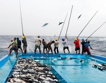
In lawaiʻa hi aku (fishing for aku,) “the slapping of the fish against the men’s sides and the arching of the bamboo poles as the aku bent them were like a double rainbow or the crescent shape of the moon of Hoaka.” (Maly)

A special canoe was used that served as a live bait well (malau,) it was joined by a double hulled canoe for the fishers (kaulua;) following the noio birds to the schooling aku, several canoes would form around them and the live bait released – then the lines of the bamboo fishing poles were cast. (Maly)

When the fish took the bait and broke water, the fisherman stood up straight and grasped the pole with both hands. The fish came completely out of the water and slapped against the side of the fisherman, who then shoved the aku forward in the canoe and cast again. (Maly)

In 1899, Gorokichi Nakasugi, a Japanese shipwright, brought a traditional Japanese sailing vessel, called a sampan, to Hawai‘i, and this led to a unique class of vessels and distinctive maritime culture associated with the rise of the commercial fishing industry in Hawai‘i. (Cultural Surveys)

The Japanese technique of catching tuna with pole-and-line and live bait resembled the aku fishing method traditionally used by Hawaiians. The pole-and-line vessels mainly targeted skipjack tuna (aku.)

In the modern fleet, with an average length of 75- to 90-feet, these boats were the largest of the sampans. The pole-and-line fleet generally fished within a few miles of the main Hawaiian Islands, because few vessels carried ice and the catch needed to be landed within four to five hours from the time of capture.

The modern fishing method used live bait thrown from a fishing vessel to stimulate a surface school into a feeding frenzy. Fishing was then conducted frantically to take advantage of the limited time the school remains near the boat.

The pole and line were about 10-feet and used a barbless hook with feather skirts which is slapped against the water until a fish strikes. Then the fish is yanked into the vessel in one motion. The fish unhooks when the line is slacked so that the process can be repeated.

On a pole-and-line vessel a fisherman was required to learn how to cast the line, jerk the fish out of the water, catch the tuna under his left arm, snap the barbless hook out, slide the fish into the hold and cast the line back out – all in rapid succession.

The fishery was dependent on having sufficient bait fish, nehu (Hawaiian anchovy;) a lot of the bait fish, came from Kāneʻohe Bay. Dozens of aku boats would set their nets in the Bay’s shallows; the pier at Heʻeia Kea Boat Harbor was homeport for more than 20 of them.

Initially, most sampans docked in Honolulu Harbor. In the 1920s, Kewalo Basin was constructed and by the 1930s was the main berthing area for the sampan fleet and also the site of the tuna cannery, fish auction, shipyard, ice plant, fuel dock and other shore-side facilities.

The Hawaiʻi skipjack tuna fishery originally supplied only the local market for fresh and dried tuna. Then, the Hawaiian Tuna Packers, Ltd. cannery was established (in 1916,) enabling the fishery to expand beyond a relatively small fresh and dried market.

Six sampans made up the cannery’s initial fleet. The fleet grew and before WWII the fishery included up to 26 vessels. Following the war, as new vessels were built, fleet size increased to a maximum of 32 vessels in 1948.

These vessels carried crews of 7-9 fishermen, and frequently worked 6 days a week. It was hard work and the fishing day may begin with catching bait fish at dawn, followed by fishing to dusk.

Historically, the pole-and-line, live bait fishery for skipjack tuna (aku) was the largest commercial fishery in Hawaiʻi. Annual pole-and-line landings of skipjack tuna exceeded 5.5 million lb from 1937 to 1973.

The new and expanding market for canned product allowed the fishery to grow; from 1937 until the early 1980s most of the skipjack tuna landed in Hawaiʻi was canned.

F Walter Macfarlane opened the Macfarlane Tuna Company at Ala Moana and Cooke street. By 1922, after having changed hands a couple times, the company was incorporated by local stockholders as Hawaiian Tuna Packers Ltd.

Around 1928, tuna processing started in Kewalo Basin. Nearby was the Kewalo Shipyard that serviced and repaired the local aku boats. They also had an ice house.

From the beginning, Hawaiian Tuna Packers label was Coral Tuna or Coral Hawaiian Brand Tuna.

By the 1930s, the Honolulu cannery employed 500 and produced nearly ten-million cans of tuna per year. For several years Hawaiian Tuna Packers also operated a smaller cannery in Hilo.

About ninety percent of the output was shipped to the mainland; the remaining ten percent was sold in Hawaiʻi. (The cans for packing the tuna are furnished by the Dole Company.)

Fishing stopped during WWII because the larger sampans were used by the military for patrol duties and the Japanese fishermen were not allowed to go to sea. (Wilson)

With the entry of the United States in the Second World War came the imposition of area and time restrictions on fishing activities in Hawai’i that virtually eliminated offshore harvesting operations. Many fishing boats were requisitioned by the Army or Navy. (Schug)

The tuna cannery was converted into a plant for the assembly of airplane auxiliary fuel tanks and the shipyard was converted to the maintenance of military craft. Hawaiʻi’s fishing industry was forever changed. (Schug)

In 1960, Castle & Cooke bought out Hawaiian Tuna Packers and made it a part of Bumble Bee Seafoods out of the northwest. They operated the cannery until late-1984, when it ultimately closed.

Follow Peter T Young on Facebook 

Follow Peter T Young on Google+ 

Follow Peter T Young on LinkedIn  

Follow Peter T Young on Blogger

© 2020 Hoʻokuleana LLC

  • OLYMPUS DIGITAL CAMERA
  • In the late 1930s, Kewalo Basin was filled with sampan fishermen

Filed Under: Economy, Sailing, Shipping & Shipwrecks Tagged With: Kewalo, Kakaako, Hawaiian Tuna Packers, Fishing, Aku, Hawaii, Sampan

November 19, 2019 by Peter T Young 1 Comment

Ke-ahi-a-Kawelo

Ka‘ā (literally translated means, “the rocky area”) is the largest ahupuaʻa on Lānaʻi, and covers almost 19,500-acres of land, the entire north end of the island.

At one time Ka‘ā supported many near-shore settlements, upland agricultural fields, resource collection/workshop areas and ceremonial sites. The residents of Ka‘ā regularly traveled between the coast and uplands, and several named localities in both climatic regions are found in native traditions and historical literature.

Traditional features, including ceremonial sites, burials, trails, residences (both long term and temporary,) salt making sites, agricultural features, lithic workshops, petroglyphs, modified caves, contest fields and sites of undetermined uses are found throughout Ka‘ā.

Native Hawaiian chants and traditions passed down over time speak loudly of the cultural and historical significance of this area.

The honu (turtle) population at Polihua is integral to the account of Pele’s migration to Hawaiʻi, and in the time when ancient Hawaiians lived at Ka‘ā the honu provided important resources for traditional subsistence.

The tradition of the Lānaʻi priest, Kawelo, and a priest of Moloka‘i identified in various accounts as either Lani-kāula or Waha – is of regional importance to the people of Lānaʻi and Moloka‘i.

Kawelo was a famous priest of Lānaʻi, who is remembered in several written accounts, dating back to at least 1868. Information collected by Kenneth Emory from Lānaʻi in 1921-1922, and accounts by other native residents, place prominent sites associated with this legend in the ahupua‘a of Ka‘ā.

In the latter tradition, we see that at Ka‘ā, Lānaʻi, Kawelo kept an altar on which a fire was burned to protect the well-being of the people of his island.

There are several narratives, with varying circumstances and different characters, but each focusses on the central theme of the priest Kawelo burning a fire on an altar in order to protect the well-being of the residents of Lānaʻi.

Kewalo on Lānaʻi and Waha on Molokaʻi challenged each other to keep a fire burning on their respective island longer than the other, and the winner’s island would be rewarded with great abundance.

The Lānaʻi kahuna, Kawelo, used every piece of vegetation in Keahiakawelo to keep his fire burning, which is why this area is so barren today.

In 1873, Walter Murray Gibson published “A Legend of Lanai” in the newspaper “Nu Hou.” Titled “Keahiakawelo” (The fire of Kawelo), in the account there are details on events of the legend and reference to the upland region of Ka‘ā:

“In the district of Kaa, on the western side of Lanai, there are several tumuli of large stones, and some rude contrivance of sacrificial altar, surrounded by a low round enclosure.”

“Here three generations anterior to the reign of Kahekili, who was King of Maui and Lanai, lived the prophet Kawelo, who kept up a constant fire burning day and night upon this altar; and a similar fire responsive to it, was maintained by another prophet Waha, on the opposite side of Molokai.”

“Now Kawelo had a daughter to assist in keeping watch and to feed the sacred fire, and Waha had a son; and it was declared to the people by these prophets, that so long as the fire burned, hogs and dogs would never cease from the land; but should it become extinguished these animals would pass away, and the kanakas would only have fish and sea-weed to eat with their poi. . . “

Gibson described how the boy Nui, of Moloka‘i, and the girl Pepe, of Lānaʻi, came to fall in love, and how on one fateful night, they failed to keep the fires on their respective islands lit – the fire on the “altar of Keahiakawelo” had died. Upon discovering their error, Nui and Pepe fled to Maui, and Kawelo:

“… threw himself headlong from a precipice of the barranca [bluff] of Maunalei. And many natives of Lanai believe to this day, that their native hogs and dogs have passed away, in consequence of the prophecy of Kawelo.”

Keahiakawelo is an otherworldly rock garden at the end of rocky Polihua Road. Located roughly 45-minutes from Lānaʻi City on the northwest side of the island, its landscape is populated with boulders and rock towers.

The region around Keahiakawelo is one of the most significant storied landscapes on Lānaʻi; there are numerous traditions describing how native Hawaiians were able to survive on Lānaʻi, and why, at one time, Lānaʻi was noted for purple colored lehua blossoms.

As the tradition of the area known as Keahiakawelo reveals, the Ka‘ā region of Lānaʻi, with the view plain to the eastern end of Moloka’i and the famed kukui tree grove of Lanikāula and Mokuhoʻoniki, is one of great significance to the history of Lānaʻi and connected by history to the larger Maui group of islands.

The rock towers, spires and formations formed by centuries of erosion are at their most enchanting at dusk. The setting sun casts a warm orange glow on the rocks illuminating them in brilliant reds and purples.

One Island legend says that the rocks and boulders were dropped from the sky by the gods tending their gardens. Another ancient tale explains that the rocks house the spirits of ancient Hawaiian warriors.

And still another legend says that the gods enjoyed creating art, and this spot on the island is where they made their favorite sculptures. They created powerful winds to literally sculpt each rock formation (perhaps explaining why there is no vegetation.)

Science suggests that these formations are the result of thousands of years of erosion that created pinnacles and buttes in one remote canyon area. Just one look, however, and you’ll wonder whether each rock has been placed for some divine purpose.

Today, many refer to this area as “Garden of the Gods.”

Follow Peter T Young on Facebook 

Follow Peter T Young on Google+ 

Follow Peter T Young on LinkedIn  

Follow Peter T Young on Blogger

© 2019 Hoʻokuleana LLC

Garden-of-the-Gods-NationalGeographic
Lanai-Monsarrat-Reg1394-1878-noting_general_area_of_Ke-ahi-a-Kawelo
Lanai-GoogleEarth-noting_location_of_Ke-ahi-a-Kawelo ('the-fire-of-Kawelo' - Garden of the Gods, Lānaʻi)
GardenOfTheGods_USGS_Quadrangle-GardenOfTheGods-1991-noting_Garden_of_the_Gods
Garden-of-the-Gods
Garden_of_the_Gods_Lanai
Garden_of_the_Gods_Keahikawelo-sign
Garden_of_the_Gods_Keahikawelo_Lanai
Garden_of_the_Gods
Garden of the Gods

Filed Under: Place Names Tagged With: Hawaii, Lanai, Kewalo, Keahiakewalo, Garden of the Gods

  • « Previous Page
  • 1
  • 2
  • 3
  • 4
  • Next Page »

Images of Old Hawaiʻi

People, places, and events in Hawaiʻi’s past come alive through text and media in “Images of Old Hawaiʻi.” These posts are informal historic summaries presented for personal, non-commercial, and educational purposes.

Info@Hookuleana.com

Connect with Us

  • Email
  • Facebook
  • LinkedIn
  • Twitter
  • YouTube

Recent Posts

  • Historic Downtown Hilo Walking Tour
  • Memorial Park
  • About 250 Years Ago … King Declares Colonies in Open Rebellion
  • Sybil’s Rocking Chair
  • Overthrow
  • Foodland
  • Kauhale

Categories

  • Ali'i / Chiefs / Governance
  • Buildings
  • Missionaries / Churches / Religious Buildings
  • Hawaiian Traditions
  • Military
  • Place Names
  • Prominent People
  • Schools
  • Sailing, Shipping & Shipwrecks
  • Economy
  • Voyage of the Thaddeus
  • Mayflower Summaries
  • American Revolution
  • General

Tags

Albatross Al Capone Ane Keohokalole Archibald Campbell Bernice Pauahi Bishop Charles Reed Bishop Downtown Honolulu Eruption Founder's Day George Patton Great Wall of Kuakini Green Sea Turtle Hawaii Hawaii Island Hermes Hilo Holoikauaua Honolulu Isaac Davis James Robinson Kamae Kamaeokalani Kameeiamoku Kamehameha Schools Lalani Village Lava Flow Lelia Byrd Liberty Ship Liliuokalani Mao Math Mauna Loa Midway Monk Seal Northwestern Hawaiian Islands Oahu Papahanaumokuakea Marine National Monument Pearl Pualani Mossman Quartette Thomas Jaggar Volcano Waikiki Wake Wisdom

Hoʻokuleana LLC

Hoʻokuleana LLC is a Planning and Consulting firm assisting property owners with Land Use Planning efforts, including Environmental Review, Entitlement Process, Permitting, Community Outreach, etc. We are uniquely positioned to assist you in a variety of needs.

Info@Hookuleana.com

Copyright © 2012-2024 Peter T Young, Hoʻokuleana LLC

Loading Comments...