Images of Old Hawaiʻi

  • Home
  • About
  • Categories
    • Ali’i / Chiefs / Governance
    • American Protestant Mission
    • Buildings
    • Collections
    • Economy
    • Missionaries / Churches / Religious Buildings
    • General
    • Hawaiian Traditions
    • Other Summaries
    • Mayflower Summaries
    • Mayflower Full Summaries
    • Military
    • Place Names
    • Prominent People
    • Schools
    • Sailing, Shipping & Shipwrecks
    • Voyage of the Thaddeus
  • Collections
  • Contact
  • Follow

April 4, 2024 by Peter T Young 1 Comment

Pioneer Company

The coming of Henry Obookiah (ʻŌpūkahaʻia) and other young Hawaiians to the continent had awakened a deep Christian sympathy in the churches and moved the American Board of Commissioners for Foreign Missions (ABCFM) to establish a mission in the Hawaiian Islands.

Among the other Hawaiian students at the Foreign Mission School were Thomas Hopu, William Kanui, John Honoliʻi and Prince Humehume (son of Kauaiʻi’s King Kaumuali‘i.)

When asked “Who will return with these boys to their native land to teach the truths of salvation?”  Hiram Bingham and his classmate, Asa Thurston, were the first to respond and offer their services to the Board.  (Congregational Quarterly)

Bingham and Thurston were ordained at Goshen, Ct on September 29, 1819; it was the first ordination of foreign missionaries in the State of Connecticut.

On October 23, 1819, the Pioneer Company of American Protestant missionaries from the northeast US set sail on the Thaddeus for the Sandwich Islands (now known as Hawai‘i.)

There were seven American couples sent by the ABCFM to convert the Hawaiians to Christianity in this first company.

These included two Ordained Preachers, Hiram Bingham and his wife Sybil and Asa Thurston and his wife Lucy; two Teachers, Mr. Samuel Whitney and his wife Mercy and Samuel Ruggles and his wife Mary; a Doctor, Thomas Holman and his wife Lucia; a Printer, Elisha Loomis and his wife Maria; and a Farmer, Daniel Chamberlain, his wife and five children.

Although a large part of the motivation for the Hawaiʻi missionary movement, Henry ʻŌpūkahaʻia unfortunately died of typhus fever in 1818 and didn’t return home to teach the gospel.  However, his book, “Memoirs of Henry Obookiah,” was the inspiration for this and subsequent Hawaiian missionary companies.

The Prudential Committee of the ABCFM in giving instructions to the pioneers of 1819 said: “Your mission is a mission of mercy, and your work is to be wholly a labor of love. … Your views are not to be limited to a low, narrow scale, but you are to open your hearts wide, and set your marks high. You are to aim at nothing short of covering these islands with fruitful fields, and pleasant dwellings and schools and churches, and of Christian civilization.”  (The Friend)

After 164-days at sea, on April 4, 1820, the Thaddeus arrived and anchored at Kailua-Kona on the Island of Hawaiʻi.  Hawai‘i’s “Plymouth Rock” is about where the Kailua pier is today.

By the time the Pioneer Company arrived, Kamehameha I had died and the centuries-old kapu system had been abolished; through the actions of King Kamehameha II (Liholiho,) with encouragement by former Queens Kaʻahumanu and Keōpūolani (Liholiho’s mother,) the Hawaiian people had already dismantled their heiau and had rejected their religious beliefs.

One of the first things Bingham and his fellow missionaries did was begin to learn the Hawaiian language and create an alphabet for a written format of the language.   Their emphasis was on teaching and preaching.

On July 14, 1826, the missionaries selected a 12-letter alphabet for the written Hawaiian language, using five vowels (a, e, i, o, and u) and seven consonants (h, k, l, m, n, p and w) in their “Report of the committee of health on the state of the Hawaiian language.”   The report is signed by Hiram Bingham and Levi Chamberlain.

The arrival of the first company of American missionaries in Hawaiʻi marked the beginning of Hawaiʻi’s phenomenal rise to literacy. The chiefs became proponents for education and edicts were enacted by the King and the council of chiefs to stimulate the people to reading and writing.

By 1831, in just eleven years from the first arrival of the missionaries, Hawaiians had built 1,103 schoolhouses. This covered every district throughout the eight major islands and serviced an estimated 52,882 students.  (Laimana)

The proliferation of schoolhouses was augmented by the printing of 140,000 copies of the pīʻāpā (elementary Hawaiian spelling book) by 1829 and the staffing of the schools with 1,000-plus Hawaiian teachers.  (Laimana)

Interestingly, these same early missionaries taught their lessons in Hawaiian, rather than English.  In part, the mission did not want to create a separate caste and portion of the community as English-speaking Hawaiians.  In later years, the instruction, ultimately, was in English.

Within five years of the missionaries’ arrival, a dozen chiefs had sought Christian baptism and church membership, including the king’s regent Kaʻahumanu.  The Hawaiian people followed their native leaders, accepting the missionaries as their new priestly class.  The process culminated in Hawaiian King Kamehameha III’s adoption of Christianity and a Biblically-based constitution in 1840.  (Schulz)

Over the course of a little over 40-years (1820-1863) (the “Missionary Period”,) about 180-men and women in twelve Companies served in Hawaiʻi to carry out the mission of the ABCFM in the Hawaiian Islands.

As did all residents of the Islands, the Missionaries had to surrender their American citizenship before they could preach. They, and their children…and their childrens’ children were Hawaiian subjects – not Americans.

US Secretary of State Daniel Webster wrote to the Commissioner in Hawaiʻi in 1851, “You inform us that many American citizens have gone to settle in the islands; if so they have ceased to be American citizens.”

“The Government of the United States must, of course, feel an interest in them not extended to foreigners, but by the law of nations they have no right further to demand the protection of this Government.”

“Whatever aid or protection might under any circumstances be given them must be given, not as a matter of right on their part, but in consistency with the general policy and duty of the Government and its relations with friendly powers.” (Webster, July 14, 1851)

In 1844, as Hawaiian Minister of Foreign Affairs, Dr. Gerrit Judd wrote the ABCFM encouraging it to allow missionaries to become naturalized Hawaiian citizens, “[The missionary] children born here are native born subjects of the king and would many of them settle here were it not for the anxiety of their parents.”  (Schulz)

The image shows the early Mission house and Chapel in Honolulu (the precursor of today’s Kawaiahaʻo Church.)

© 2024 Hoʻokuleana LLC

Filed Under: Missionaries / Churches / Religious Buildings Tagged With: Missionaries, Henry Opukahaia, Thomas Hopu, Kailua-Kona, Asa Thurston, John Honolii, William Kanui, Prince Kaumualii, Hawaii, Hiram Bingham, American Board of Commissioners of Foreign Missions

June 28, 2023 by Peter T Young Leave a Comment

Kamakahonu Royal Center

Kamakahonu Royal Center at Kailua Bay was the residential compound of Kamehameha I from 1813 until his death in 1819.
 
It had previously been the residence of a high chief, and it was undoubtedly a residential area back into the centuries prior to European contact. 
 
Kamakahonu (which literally means eyes of the turtle) was the location of multiple heiau known collectively as Ahu‘ena, originally said to have been built by either Liloa or his son Umi-a-Liloa during the sixteenth century, was reconstructed and rededicated by Kamehameha I in the early nineteenth century.
 
John Papa ʻĪʻī, attendant of Kamehameha I, to become a companion and personal attendant to Liholiho (later King Kamehameha II,) described Kamakahonu from on board a ship in 1812 …
 
“Kamakahonu was a fine cove, with sand along the edge of the sea  and  islets  of  pāhoehoe,  making  it  look like a  pond,  with a  grove of  kou trees a  little inland and a heap of pāhoehoe  in  the center of the stretch of sand.”
 
Kamehameha first moved into the former residence of Keawe a Mahi. He then built another house high on stones on the seaward side of that residence, facing directly upland toward the planting fields of Kuahewa.
 
Like an observation post, this house afforded a view of the farm lands and was also a good vantage from which to see canoes coming from the south.
 
The royal residence at Kamakahonu was served by a series of anchialine pools, upwellings of fresh and salt water found on young lava fields. These anchialine pools were used to raise bait fish and shrimp for larger catches.
 
During Kamehameha’s use of this compound, reportedly 11 house structures were present. These included his sleeping house, houses for his wives, a large men’s house, storehouses and Ahuʻena heiau. 
 
Kamehameha also included a battery of cannon and large stone walls to protect the fortress-like enclosure.
 
Upon Kamehameha’s death, a mortuary house was built, which held his remains until they were taken and hidden away.
 
After Liholiho’s departure from Hawaiʻi Island in 1820, the high chief Kuakini, who served as Governor of Hawai’i for many years, resided here until 1837, when he had Huliheʻe built and moved there.
 
By the late-1800s, Kamakahonu was abandoned and in the early-1900s H. Hackfield & Co. purchased the land, and its successor American Factors used the site as a lumberyard and later for the King Kamehameha Hotel.
 
Today, three remnant structures are present on the seaward beach of the property (all recreated in the 1970s and recently refurbished) – ‘Ahu’ena heiau, the mortuary house’s platform and an additional structural platform.
 
These structures are set aside in a covenant agreement between the State’s Historic Preservation Division and the current hotel owners.
 
Kamakahonu became the backdrop for some of the most significant events in the early nineteenth-century history of the Hawaiian Kingdom.
 
Three momentous events occurred here which established Kamakahonu as one of the most historically significant sites in Hawaiʻi:
  • In the early morning hours of May 8, 1819 King Kamehameha I died here.
  • A few months after the death of his father, Liholiho (Kamehameha II) broke the ancient kapu system, a highly defined regime of taboos that provided the framework of the traditional Hawaiian socio-economic structure
  • The first Christian missionaries from New England were granted permission to come ashore here on April 4, 1820.
The property is now part of King Kamehameha’s Kona Beach Hotel; none of the original houses or walls remain.
 
Ahuʻena heiau was reconstructed in the 1970s at 2/3-scale and can be viewed, but not entered.
 
The small sandy beach provides a protected beach for launching canoes and children swimming.  The first Hotel was built here in 1950; it was imploded (boy, that was an exciting day in Kona) and the current one constructed in 1975.
 
Kamakahonu is one of the featured Points of Interest in the Royal Footsteps Along The Kona Coast Scenic Byway.  We prepared the Corridor Management Plan for the Scenic Byway.
 
© 2023 Ho‘okuleana LLC
 

Filed Under: Ali'i / Chiefs / Governance, Hawaiian Traditions, Place Names Tagged With: Hawaii, Kamehameha, Kailua-Kona, Liholiho, Kamakahonu, Royal Footsteps Along The Kona Coast

June 7, 2023 by Peter T Young Leave a Comment

Royal Footsteps Along the Kona Coast

Royal Footsteps Along the Kona Coast Scenic Byway covers the entire length of Ali‘i Drive, seven miles of roadway and over seven centuries of Hawaiian Royalty archaeological, historic and cultural traditions that have shaped Hawai‘i into what it is today.
 
By whatever means (vehicle, transit, bicycle or on foot,) following the footsteps of ancient royalty and embracing the scenic beauty, natural and archaeological features, historic sites, associated cultural traditions and recreational opportunities will give the traveler a greater appreciation and understanding of Hawai‘i’s past and sense of place in the world.
 
Here are selected Points of Interest along the Scenic Byway:
 
1 – Kailua Seawall –  first built in 1900, the entry to Historic Kailua Village begins on Ali‘i Drive where its oceanfront promenade offers sweeping vistas of Kailua Bay, from Kamakahonu and Kailua Pier to Hulihe‘e Palace
 
2 – Pa o ‘Umi – marks the location of the landing and residence of the ruler ‘Umi-a-liloa (‘Umi) (ca. AD 1490-1525.)  Modern seawall and road construction has covered most of Pa o ‘Umi
 
3 – Hulihe‘e Palace – built in 1838, Kona’s only existing royal palace and one of three palaces in the United States
 
4 – Moku‘aikaua Church – built in 1837, it is the oldest Christian Church in Hawai‘i
 
5 – Hale Halawai – means “meeting house” and serves as a community meeting facility under the County Parks and Recreation program
 
6 – Ōneo Bay – scenic panoramic views of the shoreline and seasonal surfing -favorite place for residents and visitors to enjoy Kona’s famous sunsets
 
7 – Wai‘aha Beach Park – also known as Honl’s – “birth-beach and the birthplace” of modern bodyboarding (in 1971, Tom Morey created boogie board and first used it here)
 
8 – Kahului Bay – nicknamed Tiki’s after the adjacent small hotel (Kona Tiki Hotel,) lovely ocean vista
 
9 – Hale Halawai O Hōlualoa – stone church structure was built entirely by native Hawaiians under the direction of John D. Paris 1850-55
 
10 – Puapua‘a – popular local surf spot that once served as a canoe landing, now referred to as “Banyans”
 
11 – Hōlualoa Bay – oral traditions suggest King Kamehameha I learned to excel in board and canoe surfing in these very waters
 
12 – Hōlualoa Royal Center – Hōlualoa Royal Center includes Kamoa Point/Keolonahihi Complex, Keakealaniwahine Residential Complex and Kaluaokalani
 
13 – Jud Trail – constructed between 1849 and 1859 and intended to link the Kona area with Hilo – construction was abandoned when portions of the trail were covered by a lava flow in 1859
 
14 – Pāhoehoe Beach Park – County park with picnic and portable restroom facilities.  Ocean access is via coral rubble and rocky shore
 
15 – La‘aloa Beach Park – also known as White Sands, Magic Sands or Disappearing Sands
 
16 – La‘aloa Bay – small cove on the south side of the parking lot, entry point for snorkelers and divers
 
17 – Ku‘emanu Heiau – overlooks Kahalu‘u Bay and is associated with surfing – adjacent Waikui Pond was convenient for chiefs to bathe after an ocean outing
 
18 – St. Peter’s by the Sea Catholic Church – originally built in 1880, the church was dismantled and carried piece by piece to its present site at Kahalu’u in 1912
 
19 – Kahalu‘u Bay Beach Park – served as the Royal Center of Ali‘i, residence of Lonoikamakahiki ca. 1640-1660 and oral histories note its use by Alapa‘inui, Kalani‘ōpu‘u and Kamehameha — successive rulers from 1740-1760 on
 
20 – Helani Church –‘Ōhi‘amukumuku Heiau – old Helani Church (built in 1861 by Rev. John D. Paris) built atop the former ‘Ōhi‘amukumuku Heiau
 
21 – Hāpaiali‘i Heiau and Ke‘ekū Heiau – Hāpaiali‘i Heiau was built around 1411-1465; Ke‘ekū Heiau – after building it, Lonoikamakahiki attacked and defeated Kamalalawalu, king of Maui
 
22 – Mākole‘ā Heiau – also known as Ke‘ekūpua‘a, built (or consecrated) by Lonoikamakahiki and that it was used for prayers in general
 
23 – Heritage Corridor Overlook – pull out on Ali‘i Drive includes interpretive sign explaining the archaeological and historical significance of the lands of Kahalu‘u and Keauhou
 
24 – Royal Hōlua Slide – stone ramp nearly one mile in length that culminated at He‘eia Bay – this is the largest and best-preserved hōlua course, used in the extremely dangerous toboggan-like activity
 
25 – Lekeleke Burial Grounds – Following the death of Kamehameha I in 1819, Liholiho declared an end to the kapu system; Kekuaokalani (Liholiho’s cousin) and his wife Manono opposed the abolition and went to battle, here is the burial ground
 
S-1 – Kamakahonu Royal Center at Kailua Bay – residential compound of Kamehameha I from 1813 until his death in 1819; the center of political power in the Hawaiian kingdom during Kamehameha’s golden years
 
S-2 – Ahu‘ena Heiau – reconstructed by King Kamehameha the Great between 1812-1813; he dedicated it to Lono, god of healing and prosperity of the land
 
S-3 – Keauhou Royal Center at Keauhou Bay – ocean access at Keauhou Bay is superb and, just as boats use it today, canoe landings once dotted the shore.  The royal canoe landing of King Kamehameha I was located at Pueo Cove
 
S-4 – Kamehameha III (Kauikeaouli) Birthsite – son of Kamehameha I and high chiefess Keōpūolani, he was ruler of the Kingdom of Hawai‘i for thirty years from 1825-1854
 
We prepared the Corridor Management Plan (CMP) for the Royal Footsteps Along the Kona Coast Scenic Byway, the first CMP to be accepted by the State of Hawai‘i Department of Transportation.
 
We are proud and honored that American Planning Association-Hawai‘i Chapter selected Royal Footsteps Along the Kona Coast for the “Environment/Preservation Award”, Historic Hawaiʻi Foundation awarded the 2011 Historic Preservation Commendation and Kona-Kohala Chamber of Commerce awarded the 2011 Pualu Award for Culture & Heritage.
 
© 2023 Ho‘okuleana LLC

Filed Under: Economy, General, Place Names Tagged With: Historic Hawaii Foundation, Scenic Byway, Royal Footsteps Along The Kona Coast, Alii Drive, Hawaii, Kona, Kailua-Kona

March 22, 2023 by Peter T Young Leave a Comment

Keahuolū

The area of North Kona between Kailua Bay and Keauhou Bay to the south is generally recognized as containing the population core and the most fertile agricultural area of North Kona (Kona Kai ʻOpua “Kona of the distant horizon clouds above the ocean”.)  (Maly)

To the north of Kailua Bay, beginning at Honokōhau, is the relatively dry Kekaha district of North Kona, with its barren lava inlands and coastal fishponds (Kekaha-wai-ʻole-nā-Kona (the waterless place of Kona, it’s described as “a dry, sun-baked land.”)

Keahuolū is situated in the transition zone between these two contrasting environmental districts, and is immediately north of Kailua Bay, a center of both political and economic activities since before Western contact.

Keahuolū has been translated in a couple ways, “Ke-ahu-o-Lū” (the ahu (or alter) of Lū) and “Keʻohuʻolu” (the refreshing mists) – similar to the neighboring (to the south) Lanihau ahupuaʻa (cool heaven.)

A hill at Keahuolū and adjoining Kealakehe (to the north) is associated with mists.  “The settling of mists upon Puʻu O Kaloa was a sign of pending rains; thus the traditional farmers of this area would prepare their fields.”  (This notes the importance of rain in this relatively dry area.)  (Cultural Surveys)

Several general settlement pattern models have been generated by researchers that generally divide up the region into five basic environmental zones: the Shoreline, Kula, Kaluʻulu, ʻApaʻa and ʻAmaʻu.

Habitation was concentrated along the shoreline and lowland slopes, and informal fields were probably situated in the Kula and higher elevations, areas with higher rainfall.

The Shoreline zone extends, typically, from the high-tide line inland a few hundred feet. In Kailua this is the area from the shore to approximately Aliʻi Drive.  In this zone, permanent settlement began in Kona c. AD 1000-1200.

Several large and densely populated royal centers were situated at several locations along the shoreline between Kailua and Honaunau.

Several heiau were noted along the coast. Stokes described three coastal heiau sites in Keahuolū: Halepuʻa, Kawaluna and Palihiolo. Halepuʻa was described by Stokes as a koʻa, or fishing shrine, near the shore in a coconut grove.

Kawaluna Heiau was described by Stokes as a rebuilt enclosure located on the beach at Pāwai Bay. Heiau of Palihiolo was at or near the Keahuolū/Lanihau boundary, King Kalākaua had it rebuilt prior to his departure from Hawaiʻi.  (Rosendahl)

The Kula zone (the plain or open country) consisted primarily of dry and open land with few trees and considerable grass cover.

With limited soil, and lots of rock, this land was planted primarily in scattered sweet potato patches.  (This area was around the 500-foot elevation mark, and may extend further, to approximately the 600-800-foot elevation.)

The Kaluʻulu is zone is referred to as the breadfruit zone. Early explorers described this zone as breadfruit with sweet potatoes and wauke (paper mulberry) underneath; it may have been perhaps one-half mile wide. Here walled fields occur at the 600-800-foot elevation, which may be start of this breadfruit zone in this area.

The ʻApaʻa zone is described as a dryland taro and sweet potato zone (1,000-foot elevation and extended to the 2,500-foot elevation.) In historic accounts it is described as an area divided by low stone and earth walls into cleared rectangular fields in which sweet potato and dryland taro were planted. On the edges of the walls, sugarcane and ti were planted.

The ʻAmaʻu zone is the banana zone, which may extend from the 2,000-foot elevation to 3,000-feet, and is characterized by bananas and plantains being grown in cleared forest areas.  (Rosendahl)

William Ellis (1822) noted, “The houses which are neat, are generally erected on the sea-shore, shaded with cocoanut and kou trees, which greatly enliven the scene.”

“The environs were cultivated to a considerable extent; small gardens were seen among the barren rocks on which the houses are built, wherever soil could be found sufficient to nourish the sweet potato, the watermelon, or even a few plants of tobacco, and in many places these seemed to be growing literally in the fragments of lava, collected in small heaps around their roots.”

King Kalākaua later (1869) noted, “Keahuolu runs clear up to the mountains and includes a portion of nearly half of Hualalai mountains.  On the mountains the koa, kukui and ohia abounds in vast quantities.  The upper land or inland is arable, and suitable for growing coffee, oranges, taro, potatoes, bananas &c.”

” Breadfruit trees grow wild as well as Koli (castor-oil) oil seed.  The lower land is adopted for grazing cattle, sheep, goats &c.  The fishery is very extensive and a fine grove of cocoanut trees of about 200 to 300 grows on the beach.”

A sisal plantation was planted in Keahuolu in the late-1890s, a mill was constructed nearby; sisal was used to make rope and other fibers.  Operating until 1924, the McWayne sisal tract included about 1,000-acres of sisal fields in Keahuolu and adjoining Kealakehe.  (You can still see sisal plants, remnants of the sisal plantation, as you drive up Palani Road.)

A fishing village with a canoe landing was at Pāwai Bay.  Makaʻeo (later (July 10, 1949) developed into the Kailua Airport (commercial aviation ended there July 1, 1970)) had a large cocoanut grove, with a coastal trail running through it connecting Kailua Village to the Māmalahoa Trail.

The Kuakini Wall (1830-1844,) built to keep the free-ranging livestock out of the coastal settlements and gardens, extends from Kahaluʻu Bay to the southern portion of Keahuolu (with an average distance of about 1 ½ miles from the coastline.)  It goes to, but not through, Keahuolū at its northern terminus.

The ahupuaʻa of Keahuolū was awarded to Analeʻa Keohokālole ((c. 1816-1869) mother of King Kalākaua and Queen Liliʻuokalani) during the Māhele of 1848. Two walled houselots in Keahuolū had been held by Keohokālole’s ancestors “from very ancient times”.

Keohokālole was a great-granddaughter of both Kameʻeiamoku and Keaweaheulu two of the important chiefs who supported Kamehameha I in his rise to power.

Kameʻeleihiwa states, “Keohokālole was regarded by the Kamehameha clan as an Aliʻi Nui in honor of the great courage and loyalty proffered by her ancestors in their support of Kamehameha.”

As Aliʻi Nui, Keohokālole held the fifth largest number of ʻāina after the Māhele with 50 parcels.  She relinquished 48% of her original 96 ʻāina to the Mōʻī (King) retaining 23-parcels on Hawaiʻi, 25 on Maui and two on Oʻahu. Of her lands on the island of Hawaiʻi, two-thirds were located in the Kona District.  (Wong-Smith)

Keohokālole sold portions of her 15,000-20,000-acre grant to the government and other parties, with the balance being transferred to her heir, Liliʻuokalani.

In her Deed of Trust dated December 2, 1909, which was later amended in 1911, Queen Lili‘uokalani entrusted her estate to provide for orphan and destitute children in the Hawaiian Islands, with preference for Hawaiian children. Her legacy is perpetuated through the Queen Liliʻuokalani Children’s Center.

© 2023 Hoʻokuleana LLC


Filed Under: General, Ali'i / Chiefs / Governance, Place Names Tagged With: Liliuokalani, Ane Keohokalole, Queen Liliuokalani, Kona, Kailua-Kona, Keahuolu, Hawaii, Hawaii Island

February 10, 2023 by Peter T Young Leave a Comment

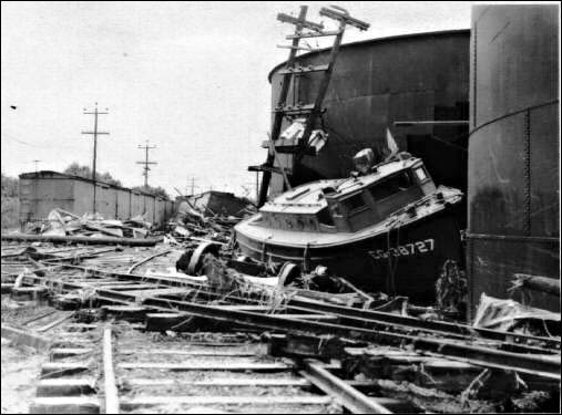
Tsunami in Hawai‘i

A tsunami is a series of ocean waves generated by sudden displacements in the sea floor, landslides or volcanic activity.  In the deep ocean, the tsunami wave may only be a few inches high.  The tsunami wave may come gently ashore or may increase in height to become a fast moving wall of turbulent water several meters high.
 
In Hawaii, tsunamis have accounted for more lost lives than the total of all other local disasters.  In the 20th century, an estimated 221 people have been killed by tsunamis.  Most of these deaths occurred on the Big Island during the tsunamis of 1946 and 1960, two of the largest tsunamis to strike in the Pacific.
 
Here is a brief summary of some recent tsunami and their impacts in Hawai‘i:
 
1946
The tsunami of 1946 was generated by a magnitude 7.1 earthquake in the Aleutian Islands.  This tsunami struck the Big Island of Hawaii on April 1st.  The tsunami flooded the downtown area of Hilo killing 159 people and causing more than $26-million in damages.
 
1952
On November 4, 1952 a tsunami was generated by a magnitude 8.2 earthquake on the Kamchatka Peninsula in the USSR.  In Hawaii, property damage from these waves was estimated at $800,000-$1,000,000 (1952 dollars); no lives were lost.  The waves beached boats, caused houses to collide, destroyed piers, scoured beaches and moved road pavement.
 
1957
On March 9, 1957 a tsunami was generated by a magnitude 8.3 earthquake in the Aleutian Islands.  It generated a 24-foot tsunami that did great damage on Adak Island, especially to the fuel and oil docks.  The Hawaiian Islands incurred about $5,000,000 of damage in 1957 dollars.  The highest wave in Hawaii was 12-feet.
 
1960
The tsunami of May 23, 1960 was generated by a magnitude 8.3 earthquake in Chile.  The 35-foot tsunami struck Hilo, Hawaii causing severe damage.  61-deaths were recorded and $23-million in damage occurred.  In the area of maximum destruction, only buildings of reinforced concrete or structural steel and a few others sheltered by these buildings, remained standing – and even these were generally gutted.  Frame buildings were either crushed or floated nearly to the limits of the flooding.
 
1975
On November 29, 1975, an earthquake occurred off the coast of the Big Island of Hawaii.  When the quake-generated tsunami struck, 32 campers were at Halape Beach Park.  The sound of falling rocks from a nearby cliff, along with earth movement caused the campers to flee toward the ocean.  They were then forced back to the cliff by rising ocean waters.  The first wave was 5-feet high, but the second wave was 26-feet high and carried the unfortunate campers into a ditch near the base of the cliff, where they remained until the ordeal ended.  Two campers died and 19 suffered injuries.
 
2011
An earthquake measured at 9.0 magnitude, the sixth biggest since 1900, struck Japan on March 11, 2011.  The first tsunami waves reached Kaua‘i shortly after 3 a.m. and took about 30 minutes to sweep through the island chain.  Waves above 6-feet were recorded at Kahului on Maui and 3-feet at Haleiwa on the north shore of Oahu.  Lost homes, sunken boats, Kona Village Resort damage, and damaged piers and roads caused tsunami damage into the tens of millions of dollars; no one was killed or injured during the tsunami.
 
The earliest historical account of a Hawaii tsunami was from a 16th century Hawaiian chant that described a huge wave that struck the coast of Molokai.
 
The earliest confirmed tsunami was on Dec 21, 1812, when a wave from Southern California was observed at Ho‘okena on the west coast of the Big Island (Hawai‘i island). Maximum runups in excess of 15 m were measured for the 1946 and 1957 distant tsunamis and the 1975 local tsunami.
 
The record shows that damaging tsunamis from distant earthquakes reached Hawaii these years: 1837, 1841, 1868, 1869, 1877, 1883, 1906, 1918, 1923, 1933, 1946, 1957, and 1960. Other smaller tsunamis that caused no significant damage in Hawaii were generated by distant earthquakes in 1896, 1901, 1906, 1919, 1922, 1923, two in 1927, 1928, 1929, 1931, 1938, 1944, 1952, and 1964.
 
In a period of 157 years, a damaging or destructive tsunami struck the Hawaiian Islands on the average of once in every twelve years.
 
© 2023 Ho‘okuleana LLC

Filed Under: General Tagged With: Hawaii, Hilo, Tsunami, Kailua-Kona

  • « Previous Page
  • 1
  • 2
  • 3
  • 4
  • …
  • 7
  • Next Page »

Images of Old Hawaiʻi

People, places, and events in Hawaiʻi’s past come alive through text and media in “Images of Old Hawaiʻi.” These posts are informal historic summaries presented for personal, non-commercial, and educational purposes.

Info@Hookuleana.com

Connect with Us

  • Email
  • Facebook
  • LinkedIn
  • Twitter
  • YouTube

Recent Posts

  • Canuck
  • About 250 Years Ago … Battles of the South
  • Keʻelikōlani and Pele
  • Common Hawaiian-sounding Words … But Are They Hawaiian?
  • From Job to Job Around the World
  • Parker Ranch Manager’s House
  • Hālawa

Categories

  • General
  • Ali'i / Chiefs / Governance
  • Buildings
  • Missionaries / Churches / Religious Buildings
  • Hawaiian Traditions
  • Military
  • Place Names
  • Prominent People
  • Schools
  • Sailing, Shipping & Shipwrecks
  • Economy
  • Voyage of the Thaddeus
  • Mayflower Summaries
  • American Revolution

Tags

Albatross Al Capone Ane Keohokalole Archibald Campbell Bernice Pauahi Bishop Charles Reed Bishop Downtown Honolulu Eruption Founder's Day George Patton Great Wall of Kuakini Green Sea Turtle Hawaii Hawaii Island Hermes Hilo Holoikauaua Honolulu Isaac Davis James Robinson Kamae Kamaeokalani Kameeiamoku Kamehameha Schools Lalani Village Lava Flow Lelia Byrd Liberty Ship Liliuokalani Mao Math Mauna Loa Midway Monk Seal Northwestern Hawaiian Islands Oahu Papahanaumokuakea Marine National Monument Pearl Pualani Mossman Quartette Thomas Jaggar Volcano Waikiki Wake Wisdom

Hoʻokuleana LLC

Hoʻokuleana LLC is a Planning and Consulting firm assisting property owners with Land Use Planning efforts, including Environmental Review, Entitlement Process, Permitting, Community Outreach, etc. We are uniquely positioned to assist you in a variety of needs.

Info@Hookuleana.com

Copyright © 2012-2024 Peter T Young, Hoʻokuleana LLC

Loading Comments...