Images of Old Hawaiʻi

  • Home
  • About
  • Categories
    • Ali’i / Chiefs / Governance
    • American Protestant Mission
    • Buildings
    • Collections
    • Economy
    • Missionaries / Churches / Religious Buildings
    • General
    • Hawaiian Traditions
    • Other Summaries
    • Mayflower Summaries
    • Mayflower Full Summaries
    • Military
    • Place Names
    • Prominent People
    • Schools
    • Sailing, Shipping & Shipwrecks
    • Voyage of the Thaddeus
  • Collections
  • Contact
  • Follow

February 10, 2023 by Peter T Young Leave a Comment

Tsunami in Hawai‘i

A tsunami is a series of ocean waves generated by sudden displacements in the sea floor, landslides or volcanic activity.  In the deep ocean, the tsunami wave may only be a few inches high.  The tsunami wave may come gently ashore or may increase in height to become a fast moving wall of turbulent water several meters high.
 
In Hawaii, tsunamis have accounted for more lost lives than the total of all other local disasters.  In the 20th century, an estimated 221 people have been killed by tsunamis.  Most of these deaths occurred on the Big Island during the tsunamis of 1946 and 1960, two of the largest tsunamis to strike in the Pacific.
 
Here is a brief summary of some recent tsunami and their impacts in Hawai‘i:
 
1946
The tsunami of 1946 was generated by a magnitude 7.1 earthquake in the Aleutian Islands.  This tsunami struck the Big Island of Hawaii on April 1st.  The tsunami flooded the downtown area of Hilo killing 159 people and causing more than $26-million in damages.
 
1952
On November 4, 1952 a tsunami was generated by a magnitude 8.2 earthquake on the Kamchatka Peninsula in the USSR.  In Hawaii, property damage from these waves was estimated at $800,000-$1,000,000 (1952 dollars); no lives were lost.  The waves beached boats, caused houses to collide, destroyed piers, scoured beaches and moved road pavement.
 
1957
On March 9, 1957 a tsunami was generated by a magnitude 8.3 earthquake in the Aleutian Islands.  It generated a 24-foot tsunami that did great damage on Adak Island, especially to the fuel and oil docks.  The Hawaiian Islands incurred about $5,000,000 of damage in 1957 dollars.  The highest wave in Hawaii was 12-feet.
 
1960
The tsunami of May 23, 1960 was generated by a magnitude 8.3 earthquake in Chile.  The 35-foot tsunami struck Hilo, Hawaii causing severe damage.  61-deaths were recorded and $23-million in damage occurred.  In the area of maximum destruction, only buildings of reinforced concrete or structural steel and a few others sheltered by these buildings, remained standing – and even these were generally gutted.  Frame buildings were either crushed or floated nearly to the limits of the flooding.
 
1975
On November 29, 1975, an earthquake occurred off the coast of the Big Island of Hawaii.  When the quake-generated tsunami struck, 32 campers were at Halape Beach Park.  The sound of falling rocks from a nearby cliff, along with earth movement caused the campers to flee toward the ocean.  They were then forced back to the cliff by rising ocean waters.  The first wave was 5-feet high, but the second wave was 26-feet high and carried the unfortunate campers into a ditch near the base of the cliff, where they remained until the ordeal ended.  Two campers died and 19 suffered injuries.
 
2011
An earthquake measured at 9.0 magnitude, the sixth biggest since 1900, struck Japan on March 11, 2011.  The first tsunami waves reached Kaua‘i shortly after 3 a.m. and took about 30 minutes to sweep through the island chain.  Waves above 6-feet were recorded at Kahului on Maui and 3-feet at Haleiwa on the north shore of Oahu.  Lost homes, sunken boats, Kona Village Resort damage, and damaged piers and roads caused tsunami damage into the tens of millions of dollars; no one was killed or injured during the tsunami.
 
The earliest historical account of a Hawaii tsunami was from a 16th century Hawaiian chant that described a huge wave that struck the coast of Molokai.
 
The earliest confirmed tsunami was on Dec 21, 1812, when a wave from Southern California was observed at Ho‘okena on the west coast of the Big Island (Hawai‘i island). Maximum runups in excess of 15 m were measured for the 1946 and 1957 distant tsunamis and the 1975 local tsunami.
 
The record shows that damaging tsunamis from distant earthquakes reached Hawaii these years: 1837, 1841, 1868, 1869, 1877, 1883, 1906, 1918, 1923, 1933, 1946, 1957, and 1960. Other smaller tsunamis that caused no significant damage in Hawaii were generated by distant earthquakes in 1896, 1901, 1906, 1919, 1922, 1923, two in 1927, 1928, 1929, 1931, 1938, 1944, 1952, and 1964.
 
In a period of 157 years, a damaging or destructive tsunami struck the Hawaiian Islands on the average of once in every twelve years.
 
© 2023 Ho‘okuleana LLC

Filed Under: General Tagged With: Hawaii, Hilo, Tsunami, Kailua-Kona

April 2, 2022 by Peter T Young 1 Comment

Largest Earthquake in Hawaiʻi

Magnitude 7.9, Kaʻū, Island of Hawaiʻi, April 2, 1868

On March 27, 1868, whaling ships at Kawaihae on the west coast of Hawaiʻi observed dense clouds of smoke rising from Mauna Loa’s crater, Mokuʻāweoweo, to a height of several miles and reflecting the bright light from the lava pit.

Slight shocks were felt at Kona on the west coast and Kaʻū on the flanks of the volcano.

On the 28th, lava broke out on the southwest flank and created a 15-mile flow to the sea. Over 300 strong shocks were felt at Kaʻū and 50 to 60 were felt at Kona.

At Kilauea, the surface of the ground quivered for days with frequent vigorous shocks that caused lamps, crockery and chairs to spin around as if animated.

One shock resembled that of a cannon projectile striking the ground under the proprietor’s bed, causing him to flee, according to the narrative published by C. H. Hitchcock in the Bulletin of the Seismological Society of America in 1912.

Between March 28, 1868 and April 11, over 2,000 distinct shocks were felt at Kona.

The main shocks struck on April 2, at 4:00 p.m., and again on April 4 at 12:30 a.m., the epicenter was located near Waiohinu.

“Thursday, April 2d, at a few minutes past four, p.m., the big earthquake occurred, which caused the ground around Kilauea to rock like a ship at sea. At that moment, there commenced fearful detonations in the crater, large quantities of lava were thrown up to a great height; portions of the wall tumbled in.”

“This extraordinary commotion, accompanied with unearthly noise and ceaseless swaying of the ground continued from that day till Sunday night, April 5th”. (Hawaiian Gazette, May 6, 1868)

A magnitude of 7 ¾ was estimated for this earthquake (by Augustine Furumoto in his February 1966 article on the Seismicity of Hawaii in the Bulletin of the Seismological Society of America) based on the extent of intensity reports.  (Instrumental recordings, the usual basis for computing magnitudes, were not available at this early date.)

The shock was felt throughout the islands, as far as Niʻihau about 350 miles away.

The ground rolled like a ship at sea and many walls tumbled down.

A landslide three miles long and thirty feet thick swept down the hill carrying trees, animals, and men.  Thirty-one people and thousands of cattle, sheep, horses and goats were killed in the one slide.

A tsunami struck the coast from Hilo to South Cape, being most destructive at Keauhou, Puna and Honuʻapo; 180 houses were washed away and 62 lives were lost to the wave alone.

A 10-foot-high wave carried wreckage inland 800-feet. Not a house survived at Honuʻapo. A stone church and other buildings were destroyed at Punaluʻu.

Maximum wave heights were 65 feet, the highest observed on Hawaiʻi to date.

At Keauhou (now Keauhou Landing) the water rose 35-50-feet destroying all the houses and warehouses and drowning 46 people. At Hilo, the height of the wave was about 10-feet, and at Kealakekua, 6-feet. The tsunami also was observed on Maui and Oʻahu. Also felt on Lānaʻi, Maui, Oʻahu, and Kauaʻi.

“The tidal wave was much greater than before stated. It rolled in over the tops of the cocoanut trees, probably sixty feet high, and drove the floating rubbish, timber, etc., inland a distance of a quarter of a mile in some places, taking out to sea when it returned, houses, men, women, and almost everything movable. The villages Punaluu, Ninole, Kawaa and Honuapo were utterly annihilated.”  (American Journal of Science, 1868)

This major earthquake caused 77 deaths (tsunami, 46; landslide, 31).

It knocked almost all wooden houses off their foundations in the Keiawa, Punaluʻu and Nīnole areas. In those areas, straw houses supported by posts in the ground reportedly were “torn to shreds.”

At Kaʻū, the more substantial houses and every stone wall were thrown down.

At Waiʻōhinu, a large stone church collapsed within 10 seconds of the onset of shaking. The shock “ruined” the few stone buildings in Hilo and shook down almost every wall. Brooks became muddy.

At Kealakekua, strong trees were bent backward and forward “like reeds in a storm.” Ground waves as much as 2-feet from ground to crest were observed at Kohala.

The motion was so violent at ʻUlupalakua that it was difficult for people to stand. Reports from Keaiwa and Kiolakaʻa suggest that vertical accelerations larger than 1g may have occurred (which means that the force of the earth pushing up on something is stronger than the force of gravity keeping it on the ground.)

Extensive surface effects were observed in the epicentral region. Ground fissures extended from Pahala to Kilauea. At Kahuku, a fissure about 5 kilometers long was reported. A volcanic eruption took place from that fissure a few days later, on April 7.

Along the Puna coast, the land subsided in places as much as 6-feet. At Kaimū, trees stood about 8-feet deep in sand and water. The plain at Kalapana sank about 6-feet, and water stood as much as 5-feet deep over 20 acres of formerly dry land.

Much of the information here is from USGS, with some noted from the diary and letters of Mrs. Sarah J. Lyman, wife of missionary David Layman in Hilo.

© 2022 Hoʻokuleana LLC

Largest Earthquake in Hawaiʻi - Magnitude 7.9, Kaʻū, Island of Hawaiʻi, April 2, 1868-400
Largest Earthquake in Hawaiʻi - Machado
Largest Earthquake in Hawaiʻi – Machado

Filed Under: General Tagged With: Hawaii, Tsunami, Earthquake

June 29, 2018 by Peter T Young 1 Comment

Tsunami

A tsunami is a series of ocean waves generated by sudden displacements in the sea floor, landslides or volcanic activity. In the deep ocean, the tsunami wave may only be a few inches high.

The tsunami wave may come gently ashore or may increase in height to become a fast moving wall of turbulent water several meters high.

On March 27, 1868, whaling ships at Kawaihae on the west coast of Hawaiʻi observed dense clouds of smoke rising from Mauna Loa’s crater, Mokuʻāweoweo, to a height of several miles and reflecting the bright light from the lava pit.

On the 28th, lava broke out on the southwest flank and created a 15-mile flow to the sea. Over 300 strong shocks were felt at Kaʻū and 50 to 60 were felt at Kona.

At Kilauea, the surface of the ground quivered for days with frequent vigorous shocks that caused lamps, crockery and chairs to spin around as if animated.

Between March 28, 1868 and April 11, over 2,000 distinct shocks were felt at Kona. The main shocks struck on April 2, at 4:00 p.m., and again on April 4 at 12:30 a.m., the epicenter was located near Waiohinu.

A tsunami struck the coast from Hilo to South Cape, being most destructive at Keauhou, Puna and Honuʻapo; 180 houses were washed away and 62 lives were lost to the wave alone.

A 10-foot-high wave carried wreckage inland 800-feet. Not a house survived at Honuʻapo. A stone church and other buildings were destroyed at Punaluʻu.

Maximum wave heights were 65 feet, the highest observed on Hawaiʻi to date.

At Keauhou (now Keauhou Landing) the water rose 35-50-feet destroying all the houses and warehouses and drowning 46 people. At Hilo, the height of the wave was about 10-feet, and at Kealakekua, 6-feet. The tsunami also was observed on Maui and Oʻahu. Also felt on Lānaʻi, Maui, Oʻahu, and Kauaʻi.

“The tidal wave was much greater than before stated. It rolled in over the tops of the cocoanut trees, probably sixty feet high, and drove the floating rubbish, timber, etc., inland a distance of a quarter of a mile in some places …”

“… taking out to sea when it returned, houses, men, women, and almost everything movable. The villages Punalu‘u, Ninole, Kawa‘a and Honuapo were utterly annihilated.” (American Journal of Science, 1868)

This major earthquake caused 77 deaths (tsunami, 46; landslide, 31).

Along the Puna coast, the land subsided in places as much as 6-feet. At Kaimū, trees stood about 8-feet deep in sand and water. The plain at Kalapana sank about 6-feet, and water stood as much as 5-feet deep over 20 acres of formerly dry land.

In the 20th century, an estimated 221 people have been killed by tsunamis. Most of these deaths occurred on the Big Island during the tsunamis of 1946 and 1960, two of the largest tsunamis to strike in the Pacific.

Here is a brief summary of some recent tsunami and their impacts in Hawai‘i:

1946
The tsunami of 1946 was generated by a magnitude 7.1 earthquake in the Aleutian Islands.

This tsunami struck the Big Island of Hawaii on April 1st. The tsunami flooded the downtown area of Hilo killing 159 people and causing more than $26-million in damages.

1952
On November 4, 1952 a tsunami was generated by a magnitude 8.2 earthquake on the Kamchatka Peninsula in the USSR.

In Hawaii, property damage from these waves was estimated at $800,000-$1,000,000 (1952 dollars); no lives were lost. The waves beached boats, caused houses to collide, destroyed piers, scoured beaches and moved road pavement.

1957
On March 9, 1957 a tsunami was generated by a magnitude 8.3 earthquake in the Aleutian Islands.

It generated a 24-foot tsunami that did great damage on Adak Island, especially to the fuel and oil docks. The Hawaiian Islands incurred about $5,000,000 of damage in 1957 dollars. The highest wave in Hawaii was 12-feet.

1960
The tsunami of May 23, 1960 was generated by a magnitude 8.3 earthquake in Chile.

The 35-foot tsunami struck Hilo, Hawaii causing severe damage. 61-deaths were recorded and $23-million in damage occurred.

In the area of maximum destruction, only buildings of reinforced concrete or structural steel and a few others sheltered by these buildings, remained standing – and even these were generally gutted. Frame buildings were either crushed or floated nearly to the limits of the flooding.

1975
On November 29, 1975, an earthquake occurred off the coast of the Big Island of Hawaii.

When the quake-generated tsunami struck, 32 campers were at Halape Beach Park. The sound of falling rocks from a nearby cliff, along with earth movement caused the campers to flee toward the ocean.

They were then forced back to the cliff by rising ocean waters. The first wave was 5-feet high, but the second wave was 26-feet high and carried the unfortunate campers into a ditch near the base of the cliff, where they remained until the ordeal ended. Two campers died and 19 suffered injuries.

2011
An earthquake measured at 9.0 magnitude, the sixth biggest since 1900, struck Japan on March 11, 2011.

The first tsunami waves reached Kaua‘i shortly after 3 a.m. and took about 30 minutes to sweep through the island chain. Waves above 6-feet were recorded at Kahului on Maui and 3-feet at Haleiwa on the north shore of Oahu.

Lost homes, sunken boats, Kona Village Resort damage, and damaged piers and roads caused tsunami damage into the tens of millions of dollars; no one was killed or injured during the tsunami.

Follow Peter T Young on Facebook 

Follow Peter T Young on Google+ 

Follow Peter T Young on LinkedIn  

Follow Peter T Young on Blogger

© 2018 Hoʻokuleana LLC

1960-Hilo-May 23, 1960. A huge tidal wave – a 50-footer
Tsunami_Awareness
Tsunami_Awareness
Modeled Movement of Tsunami Marine Debris
1946-Palace-tsunami-HTH
1946-Kanakea-Railway-damaged-2Bby-2B1946-2Btsunami-HI_County
1946-Hilo-tsunami_Wave_Surges_up_Wailuku_River
1960-Suisan-tsunami-NOAA
1960_Suisan-tsunami-HTH
1960_Boats at Wailoa-tsunami-HTH
1946_Tsunami-Damage_(NOAA-NGDC, Orville T. Magoon)
1946_Tsunami_Damage_(NOAA-NGDC-Orville T. Magoon)
1952-Haleiwa-tsunami. 11-04-52-Aerial view of Kaika Bay near Haleiwa shows the 4th wave climbing up the beach (National Geophysical Data Center)
1952-Hilo-boats washed ashore along the Wailoa River during 1952 tsunami-Hilo
1950s-Haleiwa-shows people catching stranded fish during the receding tsunami at Hale'iwa.
1950s-Haleiwa-shows people catching stranded fish during the receding tsunami at Hale’iwa.
1957 tsunami. 03-09-57 Arrival of a major wave at Laie Point on the Island of Oahu. (National Geophysical Data Center).
1957-Hanalei
1957-Hanalei
1957-Laie-tsunami. 03-09-57 Arrival of a major wave at Laie Point on the Island of Oahu. (National Geophysical Data Center).
1960-Hilo destruction left in the wake of tsunami generated by earthquake of May 22, 1960, off the coast of Chile.
1960-Hilo-Hilo Waterfront - On May 22, 1960, at 19-11 GMT, an earthquake occurred off the coast of South Central Chile.
1960-Hilo-Hilo Waterfront – On May 22, 1960, at 19-11 GMT, an earthquake occurred off the coast of South Central Chile.
1960_Wailoa-tsunami-HTH
1960-Clock-Time_Stands_Still
1960-Tsunami_Memorial_Clock
1960-Hilo-Path of tsunami map
1975-Halape palm grove, dead from immersion in sea water.
1975-Halape- view of the Halape coast after the 1975 tsunami.
1975-Halape- view of the Halape coast before the 1975 tsunami.
1975-Halape-Scout Troop 77 - Halape. Two days after this photo was taken on November 29, 1975, a 30-foot tsunami washed over their camp site.
1975-Halape-Scout Troop 77 – Halape. Two days after this photo was taken on November 29, 1975, a 30-foot tsunami washed over their camp site.
1975-Hilo_Boat
1975-Hilo_Boat
1975-Keauhou_Bay
1975-Keauhou_Bay
1975-Punaluu-locally generated tsunami. 11-29-75 Damage at Punalu'u, on the Big Island of Hawai'i. (Pacific Tsunami Museum Archives).
1975-Punaluu-locally generated tsunami. 11-29-75 Damage at Punalu’u, on the Big Island of Hawai’i. (Pacific Tsunami Museum Archives).
2009-Keauhou_Bay-water_receding
2009-Keauhou_Bay-water_receding_at_dock
2009-Keauhou_Bay-water_surging
2009-Keauhou_Bay-water_surging_at_dock
2011_Kailua_Bay_flooding_tsunami
2011_Tsunami_Alii_Drive_Kailua-Kona
2011-Kailua-Kona-King Kamehameha Hotel restaurant and bar
2011-Kailua-Kona-water receding
2011-Kealakekua_Bay-House_in_Bay
2011-Keauhou_Bay_Damage
2011-Keauhou_Bay-water_surging
2011-Kona-kailua-kona_flooding_2011_ tsunami wave flooding in Kailua-Kona, Hawaii on March 11. Note that pier is covered.
2011-Kona-kailuakona_receding_water_2011_tsunami wave receding in Kailua-Kona, Hawaii on March 11.
2011-Kona-kailua-kona_street_2011_street flooded and damaged in Kailua-Kona
2011-The ocean receding from Pelekane Bay at Pu`ukohola Heiau National Historic Site
2011-Japan_Tsunami (2011) Marine Debris-simulation map

Filed Under: General, Economy Tagged With: Hawaii, Tsunami

January 24, 2016 by Peter T Young 1 Comment

Laupāhoehoe

The northeastern coast of the island of Hawaiʻi presents an almost continuous succession of valleys, with intervening uplands rising gently for a few miles, and then more abruptly toward the snows of Mauna Kea and the clouds.

The rains are abundant on that side of the island, and the fertile plateau, boldly fronting the sea with a line of cliffs from fifty to a hundred feet in height, is scored at intervals of one or two miles with deep and almost impassable gulches.

The streams reach the ocean either through rocky channels worn to the level of the waves, or in cascades leaping from the cliffs and streaking the coast from Hilo to Waipiʻo.

In the time of Līloa, and later, this plateau was thickly populated, and requiring no irrigation, was cultivated from the sea upward to the line of frost. A few kalo patches are still seen, and bananas grow, as of old, in secluded spots and along the banks of the ravines. (Kalākaua)

“Lapahoi (Laupāhoehoe – leaf of lava) is a small stony flat with a few huts and sweet potatoes and taro patches scattered over it. It lies at the extremity of a deep ravine, the declivities on either side nearly 500 feet in height and extending to the sea beach, terminating in a rocky precipice.”

“The coast all the way to Lapahoi was intersected by many deep ravines, many of which had large rivers forming beautiful waterfalls that fell over the outward cliffs into the ocean, the angry surf of which broke a long way up upon the rocks underneath.” (Macrae, 1825)

“The country, by which we sailed, was fertile, beautiful, and apparently populous. The numerous plantations on the eminences and sides of the deep ravines or valleys, by which it was intersected, with the streams meandering through them into the sea, presented altogether a most agreeable prospect.”

“The coast was bold, and the rocks evidently volcanic. We frequently saw the water gushing out of hollows in the face of the rocks, or running in cascades from the top to the bottom.”

“After sailing very pleasantly for several hours, we approached Laupāhoehoe: although we had come upwards of twenty miles, and had passed not less than fifty ravines or valleys, we had not seen a spot where we thought it would be possible to land without being swamped”.

“(A)lthough we knew we had arrived at the end of our voyage, we could discover no place by which it seemed safe to approach the shore, as the surf was beating violently, and the wind blowing directly towards the land.” (Ellis, 1823)

In January 1834, David Douglas (a fir tree was named after him) visited the island of Hawai‘i, traveled around the base of Mauna Kea – including the upper Laupāhoehoe forest zone – and ascended Mauna Kea; while on his second visit to the island, he died at a location near the mauka boundary of Laupāhoehoe and Humuʻula.

In 1859, Abel Harris and FB Swain entered into a partnership and secured a section of land on the Laupāhoehoe peninsula and lower plains; they ran a trading station and attempted to undertake several business ventures, including, collection of pulu (down) from hāpuʻu tree ferns, hunting bullocks in the upper forest lands, and cultivation of sugar cane on the lowlands.

The lowlands of the Laupāhoehoe region became the focus of sugar plantation efforts as early as the 1850s. But it was not until 1876, that a full-scale plantation was incorporated, and a mill established.

At the industry’s peak in the 1930s, Hawaiʻi’s sugar plantations employed more than 50,000 workers and produced more than 1-million tons of sugar a year; over 254,500-acres were planted in sugar.

As elsewhere, sugar cultivation exploded on the Big Island. As a means to transport sugar and other goods, railroading was introduced to the Islands in 1879. All the sugar grown in East Hawaiʻi, in Puna and on the Hāmākua Coast, was transported by rail to Hilo Harbor, where it was loaded onto ships bound for the continent.

The rail line crossed over 12,000-feet in bridges, 211-water openings under the tracks, and individual steel spans up to 1,006-feet long and 230-feet in height.

Some of the most notable were those over Maulua and Honoliʻi gulches, the Wailuku River and Laupāhoehoe. Over 3,100 feet of tunnels were constructed, one of which, the Maulua Tunnel, was over half a mile in length.

While the main business of the railroad remained the transport of raw sugar and other products to and from the mills, it also provided passenger service.

Targeting tourists to augment local passenger and raw sugar transport, the Hawaiʻi Consolidated Railway ran sightseeing specials under the name “Scenic Express.”

Not for the faint of heart, rail trips included a stop on the trestles, where passengers disembarked to admire the outstanding scenery.

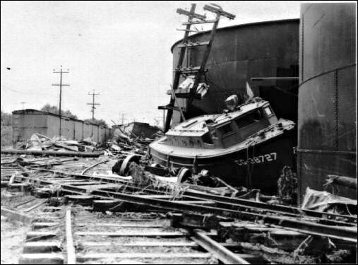
But the end was near for the railway. Early in the morning of April 1, 1946, a massive tsunami struck Hawaiʻi. The railroad line between Hilo and Paʻauilo suffered massive damage; bridges collapsed, trestles tumbled and one engine was literally swept off the tracks.

At Laupāhoehoe Point, waves destroyed teachers’ residences and flooded school grounds, killing twenty-five people, including sixteen students and five teachers of Laupāhoehoe School.

(The 1946 tsunami killed 159-people and caused $26-million in property damage throughout the islands. To prevent such widespread loss of life and property, the territory-wide Tsunami Warning System was put in place in 1948 and successfully utilized for the 1952 and 1957 tsunamis.) (hawaii-edu)

At the time of the tsunami, plantations were already phasing out rail in favor of trucking cane from the field to the mill. It was inevitable that trucking would also replace rail as the primary means of transporting sugar to the harbor. The tsunami accelerated that transition.

A few remnants of the railway are still visible. In Laupāhoehoe, a concrete platform remains where Hula dancers once performed for tourists. And the Laupāhoehoe Train Museum is housed in the former home of Mr. Stanley, the superintendent of maintenance.

Follow Peter T Young on Facebook 

Follow Peter T Young on Google+ 

Follow Peter T Young on LinkedIn  

Follow Peter T Young on Blogger

© 2016 Hoʻokuleana LLC

Laupahoehoe village-PPWD-5-4-021-1885
Laupahoehoe-PP-30-2-015-1935
Laupahoehoe-PP-30-2-014-1935
Laupahoehoe-PP-30-2-012
Laupahoehoe-PP-30-2-011-1-1890s
Laupahoehoe-PP-30-2-010-1890s
Laupahoehoe-PP-30-2-009-1930
Laupahoehoe landing-PP-30-2-004-1925
Aerial view of Laupahoehoe-PP-30-2-016-1935
Aerial view of Laupahoehoe-PP-30-2-013-after_1946
Flumes and railroad bridge on the way to Laupahoehoe-PP-30-2-005
Road to Laupahoehoe-PP-30-2-007
Hawaii Consolidated Railway Train
Passengers_Bridge
Passengers_Bridge
Bridge on the Hamakua Coast, Hawaii, c.1930
David Douglas-Memorial-Kaluakauka
Roughed out Canoe at the 4,500’ Elevation in Dense Koa forest-Sept 11, 1885
Laupahoehoe
Laupahoehoe

Filed Under: Economy, Place Names Tagged With: Hawaii Island, Tsunami, Hamakua, Laupahoehoe, Hawaii

January 7, 2015 by Peter T Young 1 Comment

Mokuola

Mokuola, in Hawaiian culture, is a place of healing.  A rock just off its shore is believed to have healing powers, and people who were sick have come to Mokuola to swim around the rock in the hopes of healing their ailments.  (Miller)

People came here for spring water believed to have healing qualities; umbilical cords of infants were hidden here under a flat stone known as Papa-a-Hina (stratum of Hina) to protect them from rats.  (Pukui)

A sea pool to the right of the landing on the island was called Puaʻa-kāheka.  Just outside of Mokuola is a small islet called Kaulaʻi-nā-iwi, literally ‘dry the bones’ (bones of chiefs were dried here.)  (Hawaii County)

Occasional reference is made to Mokuola (also now called Coconut Island) as the place of refuge of the Hilo district, hence its name, life island. Careful enquiry shows that the area of this puʻuhonua included also a portion of the mainland adjoining. The heiau connected with it, named Makaoku.  (Thrum)

Makaoku is an ʻili in Waiākea. In 1909, the Territory set aside 3.5-acres in the ʻili of Makaoku, Waiākea as the Kauikeaouli Park. Today, the Liliʻuokalani Gardens (the Japanese Gardens) and associated land has a land area of about 30-acres and is near this former park named for the earlier king (the latter is part of the golf course.)

Mokuola was repeatedly struck when tsunami entered Hilo Bay.

“We have had a great disaster at Hilo … at 5 o’clock it swept in, in a mighty wave, washing up and into nearly all the stores … But at Waiākea the damage was frightful. … There has been nothing like this tidal wave since the year 1837 … when many grass houses were destroyed.”  (Severance, Pacific Commercial Advertiser, May 26, 1877)

“The water was 3 inches deep in Conway’s store, when the 5 o’clock wave came In. The wave at Waiakea must have had a perpendicular height of 16 feet, to have taken the bridge and wharf where they now lie. The water swept completely over Cocoanut Inland, and the hospital there has disappeared.”  (Severance, Pacific Commercial Advertiser, May 26, 1877)

A tsunami struck again. “Cocoanut Island was pretty well wrecked. The wave swept it completely.  The old house formerly used by the keeper of the island, was turned completely around and swept seaward for a distance of about 20 feet and then laid flat on the ground.  A tall cocoanut tree, directly in its path was snapped off at the ground. The bathhouses were also torn down and moved some 12 feet nearer the landing place.”  (Hawai‘i Herald, February 8, 1923; Miller)

There is a coconut palm on the Island with small bands that indicate the maximum wave height of tsunami that washed over the island (8-feet, 1957; 12-feet, 1952; 15-feet, 1960; and 26-feet, 1946.)

The Spanish-American War was a conflict in 1898 between Spain and the United States, effectively the result of American intervention in the ongoing Cuban War of Independence.  Back then, Spain had interests in the Pacific, particularly in the Guam and Philippines.  Although the main issue was Cuban independence, the ten-week war was fought in both the Caribbean and the Pacific.

In the Islands, there was no assigned garrison here until August 15, 1898, when the 1st New York Volunteer Infantry regiment and the 3rd Battalion, 2nd US Volunteer Engineers landed in Honolulu for garrison duty.  They setup camp (‘Camp McKinley’) at Kapiʻolani Park.

Later (November 8, 1898,) approximately 200-soldiers of the 1st New York sailed from Honolulu to Hilo to inspect sites for a possible permanent military post – a highlight of their visit was a hike to the Kilauea volcano. The soldiers camped in the new wharf (just down the coast from Mokuola.)  (Greguras)

In 1900, the Hilo Swimming Club petitioned the government to designate Mokuola as a recreation area. Swimming facilities including a bathhouse and diving boards were built.

In 1910, a 30-foot-high wooden diving tower was built with platforms at 5-foot, 14-foot, and 30-foot levels. After it was destroyed in the tsunami of 1923, a stone tower was built with two levels, steps, springboards, and railings.

At the beginning of World War II, the military took control of Coconut Island, and the Navy used this tower to train troops in amphibious warfare.  (Valentine)

This was not the only military use on the Island.  In 1942, Mokuola USO was established, and recreational and training facilities were constructed there for American soldiers.  The facilities were officially opened to soldiers in 1943.  (Miller)

During the war, the island was restricted to military personnel. On two days per week, however, lady friends of servicemen were allowed to visit the USO, which was accessed by a pontoon bridge, the first bridge to the island. During the occupation, a new pavilion, showers and restrooms were built. The military gave the island back to the county in 1945. (Valentine)

When the island was finally turned over to the county in 1945, the pontoon bridge was put off-limits due to it being a “hazard to children and too costly to maintain.”

Boat service between the island and the shore resumed until April 1, 1946 when a devastating tsunami once again destroyed all of the structures on Mokuola except for a concrete diving tower that is believed to have been constructed by the Army Corps of Engineers for training purposes.  (Miller)

The 1960 tsunami washed completely over the island, destroying all buildings and the new bridge there. For three years, Mokuola was abandoned.

Funds were eventually allocated for a major restoration project of the island, including a new metal and concrete bridge, and new concrete walls to slow erosion.

By 1969 the bridge was completed and the park was re-opened to the public.  (Miller)  It remains a public park.

The image shows Mokuola. (DMY)   In addition, I have added others similar images in a folder of like name in the Photos section on my Facebook and Google+ pages.

Follow Peter T Young on Facebook  

Follow Peter T Young on Google+ 

Follow Peter T Young on LinkedIn   

© 2015 Hoʻokuleana LLC

Filed Under: Place Names Tagged With: Hawaii, Hawaii Island, Hilo, Coconut Island, USO, Tsunami, Waiakea, Mokuola

Images of Old Hawaiʻi

People, places, and events in Hawaiʻi’s past come alive through text and media in “Images of Old Hawaiʻi.” These posts are informal historic summaries presented for personal, non-commercial, and educational purposes.

Info@Hookuleana.com

Connect with Us

  • Email
  • Facebook
  • LinkedIn
  • Twitter
  • YouTube

Recent Posts

  • Benjamin Franklin’s ‘Examination’
  • Keahuolū
  • Shaka
  • Teshima’s
  • Waikīkī’s Construction Evolution
  • A Building Tells Stories About Buildings
  • Saint Patrick’s Day

Categories

  • General
  • Ali'i / Chiefs / Governance
  • Buildings
  • Missionaries / Churches / Religious Buildings
  • Hawaiian Traditions
  • Military
  • Place Names
  • Prominent People
  • Schools
  • Sailing, Shipping & Shipwrecks
  • Economy
  • Voyage of the Thaddeus
  • Mayflower Summaries
  • American Revolution

Tags

ABCFM Certified Shoreline Coasts Dentistry Drying Tower Ephraim Weston Clark Floating Island Foresty George Washington Hanai HECO Henry AP Carter Henry Kapena Honolulu Marathon Hookena . Kona John Adams Kuakini Cummins Kalahikiola Church Kamehameha Kam Fong Kanaina Kaneohe Yacht Club Kaunaoa Keei Kini Popo Liliuokalani Educational Society Makai Arterial Manuiki Oklahoma Paia High School Papalaua PASH Piia Ponoholo Ranch Prince Edward Real Estate Richard Boone Sam Nowlein Sarah Eliza Pierce Emerson Stamps Territorial Hospital TransPac Walter Chamberlain Peacock William Francis Quinn Yale Yokohama Specie Bank

Hoʻokuleana LLC

Hoʻokuleana LLC is a Planning and Consulting firm assisting property owners with Land Use Planning efforts, including Environmental Review, Entitlement Process, Permitting, Community Outreach, etc. We are uniquely positioned to assist you in a variety of needs.

Info@Hookuleana.com

Copyright © 2012-2021 Peter T Young, Hoʻokuleana LLC


Loading Comments...