Images of Old Hawaiʻi

  • Home
  • About
  • Categories
    • Ali’i / Chiefs / Governance
    • American Protestant Mission
    • Buildings
    • Collections
    • Economy
    • Missionaries / Churches / Religious Buildings
    • General
    • Hawaiian Traditions
    • Other Summaries
    • Mayflower Summaries
    • Mayflower Full Summaries
    • Military
    • Place Names
    • Prominent People
    • Schools
    • Sailing, Shipping & Shipwrecks
    • Voyage of the Thaddeus
  • Collections
  • Contact
  • Follow

April 26, 2022 by Peter T Young Leave a Comment

Honolulu – 1820

In the dawn hours of January 18, 1778, on his third expedition, British explorer Captain James Cook on the HMS Resolution and Captain Charles Clerke of the HMS Discovery first sighted what Cook named the Sandwich Islands (that were later named the Hawaiian Islands.)  Hawaiian lives changed with sudden and lasting impact, when western contact changed the course of history for Hawai‘i.

Forty years after Cook’s death, the Pioneer Company of American Protestant missionaries (American Board of Commissioners for Foreign Missions (ABCFM)) set sail on the Thaddeus for the Sandwich Islands (on October 23, 1819.)  There were seven American couples sent by the ABCFM to convert the Hawaiians to Christianity in this first company.  Missionaries arrived first at Kailua-Kona on April 4, 1820; they then went to Honolulu and arrived there on April 14, 1820.

Captain Cook estimated the population at 400,000 in 1778. When Vancouver, who had been with Cook, returned in 1792, he was shocked at the evidences of depopulation, and when the missionaries arrived in 1820, the population did not exceed 150,000.  (The Friend, December 1902)

By the time the missionaries arrived, Kamehameha I had died and the centuries-old kapu system had been abolished; through the actions of King Kamehameha II (Liholiho,) with encouragement by former Queens Kaʻahumanu and Keōpūolani (Liholiho’s mother,) the Hawaiian people had already dismantled their heiau and had rejected their religious beliefs.

But how were our ears astonished to hear the voice devine proclaim, “in the wilderness prepare ye the way of the Lord, make straight in the desert a highway for our God”! How were our hearts agitated with new & various & unexpected emotions, to hear the interesting intelligence, “Tamahemaha is dead,” – “The Taboos are broken” – “The Idols are burnt” – “The Moreahs (heiau) are destroyed” – and the priesthood abolished.   (Hiram Bingham and others in a letter to the ABCFM)

So, what was Honolulu like forty-years after the first arrival of foreigners?  The following, from books, journals and letters, helps to paint the picture of Honolulu.

This village (Honolulu,) which contains about two hundred houses, is situated upon a level plain extending some distance back from the bay part of which forms the harbour, to the foot of the high hills which abound throughout the Island. The little straw-huts clusters of them in the midst of cocoanut groves, look like bee-hives, and the inhabitants swarming about them like bees. In passing through the midst, in our way to the open plain, it was very pleasant to hear their friendly salutation, Alloah (Aloha,) some saying, e-ho-ah, (where going?) We answered, mar-oo, up yonder. Then, as usual, they were pleased that we could num-me-num-me Owhyhee (talk Hawaiian.)  (Sybil Bingham)

Here we dropped anchor in the peaceful waters of this safe and commodious harbor, the best in this part of the world. It is sufficiently large to admit 150 sail, of the capacity of 100 to 700 tons. The depth of water at the bar, or mouth of the harbor, being little more than twenty feet, and little affected by the tide, the largest class of ships could not pass in and out with safety, without under-girders, or camels, to buoy them up.  (Hiram Bingham)

Ships lying at harbor whose officers were interesting themselves in our object, and whom we sought to entertain at our little dwelling as much after the manner of our own country as we could— a respectful attention also to the chiefs and their suite whenever they came in and spread themselves around upon our mats.  (Sybil Bingham)

Passing through the irregular village of some thousands of inhabitants, whose grass thatched habitations were mostly small and mean, while some were more spacious, we walked about a mile northwardly to the opening of the valley of Pauoa, then turning south-easterly, ascended to the top of Punchbowl Hill an extinguished crater, whose base bounds the north-east part of the village or town.  (Hiram Bingham)

On the east were the plain and grove of Waikiki, with its amphitheater of hills, the south-eastern of which is Diamond Hill, the crater of an extinct volcano, in the form of a cone, truncated, fluted, and reeded, larger, higher, and more concave than Punchbowl Hill, but of much the same model and general character.  (Hiram Bingham)

Below us (below Punchbowl,) on the south and west, spread the plain of Honolulu, having its fish-pond and salt making pools along the sea-shore, the village and fort between us and the harbor, and the valley stretching a few miles north into the interior, which presented its scattered habitation and numerous beds of kalo (taro) in it various stages of growth, with its large green leaves, beautifully embossed on the silvery water, in which it flourishes.  (Hiram Bingham)

Through this valley, several streams descending from the mountains in the interior, wind their way, some six or seven mile watering and overflowing by means of numerous artificial canal the bottom of kalo patches, and then, by one mouth, fall into the peaceful harbor.  (Hiram Bingham)

The soil is of the best kind, producing cocoanuts, bananas, and plantains, bread fruit, papia, ohia, oranges, lemons, limes, grapes, tamarinds, sweet potatoes, taro, yams, watermelons, muskmelons, cucumbers and pineapples, and I doubt not would yield fine grain of any kind.  (Ruggles, The Friend)

There are large droves of wild cattle in the mountains, and a herd of about fifty fine ones on a large plain near this village, owned by a Spaniard who neither makes any use of them himself, nor will he permit us to, yet. There are also immense numbers of goats both wild and tame. They supply us with milk, and are excellent meat. Hogs are numerous in the mountains. Dogs abound in great numbers. I have counted 250 brought in one day to King Tamoree. They are esteemed by the natives as the best food.  (Ruggles, The Friend)

From Diamond Hill, on the east, to Barber’s Point and the mountains of Waianae, on the west, lay the sea-board plain, some twenty-five miles in length, which embraces the volcanic hill of Moanalua, two or three hundred feet high, and among them, a singular little lake of seawater, abounding in salt crystalized through evaporation by the heat of the sun, the ravine of Moanalua, the lagoon of Ewa, and numerous little plantation and hamlets, scattered trees, and cocoanut groves, range of mountains, three or four thousand feet high, stretches aero the south-western part of the island, at the distance of twenty-five miles.  (Hiram Bingham)

Another range, from two to four thousand feet high stretches from the north-western to the eastern extremity of the island. Konahuanui, the highest peak, rises back of Punchbowl Hill and north by east from Honolulu, eight miles distant, and four thou and feet high, often touching or sustaining, as it were, a cloud.  (Hiram Bingham)

We were sheltered in three native-built houses, kindly offered us by Messrs. Winship, Lewis and Navarro, somewhat scattered in the midst of an irregular village or town of thatched huts, of 3,000 or 4,000 inhabitants.  (Hiram Bingham)  “(O)ur little cottage built chiefly of poles, dried grass and mats, being so peculiarly exposed to fire, beside being sufficiently filled with three couples and things for immediate use, consisting only of one room with a little partition and one door.”  (Sybil Bingham)

In addition to their homes, the missionaries had grass meeting places, and later, churches.  One of the first was on the same site as the present Kawaiahaʻo Church.  On April 28, 1820, the Protestant missionaries held a church service for chiefs, the general population, ship’s officers and sailors in the larger room in Reverend Hiram Bingham’s house.  This room was used as a school room during the weekdays and on Sunday the room was Honolulu’s first church auditorium.  (Damon)

© 2022 Hoʻokuleana LLC

Filed Under: General, Missionaries / Churches / Religious Buildings Tagged With: 1820, Hawaii, Hiram Bingham, American Board of Commissioners of Foreign Missions, ABCFM, Sybil Bingham, Captain Cook, George Vancouver

April 23, 2022 by Peter T Young 2 Comments

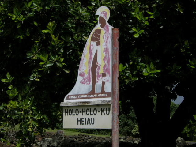
Holoholokū

Hānau ke aliʻi I loko o
Holoholokū, he aliʻi nui
Hānau ke kanaka I loko o
Holoholokū, he aliʻi no
Hānau ke aliʻi mawaho aʻe o H
Holoholokū ʻaʻohe aliʻi
he kanaka ia.

The child of a chief born in
Holoholokū is a high chief;
The child of a commoner born
in Holoholokū is a chief;
The child of a chief born outside
of the borders of Holoholokū
is a commoner.

The traditional name was Ka Lae o Ka Manu, which means the crest of the bird. Holoholokū appears to have been the ancient locality name.  (NPS)

Oral traditions tell of the sacred births of Kauaʻinui and Wailuanuihoʻano and the establishment of this area as a birthing site reserved for royalty. It is still considered as one of Hawaiʻi’s most sacred sites.  (Wailua Heritage Trail)

Holoholokū at Wailua on Kaua’i was one of two places in Hawai‘i specifically designated for the birth of high ranking children; the other site was Kūkaniloko near Wahiawa on Oʻahu.

Here all the kings of Kauaʻi were born, from earliest times to King Kaumualiʻi.  Aliʻi from other islands would also come here to give birth.

Kaumuali‘i was the only son of Kamakahelei and Kāʻeo (his mother Kamakahelei ruled the island when Captain James Cook made ‘contact’ in 1778.)  Kaumualiʻi was born the same year at Holoholokū. Kaumuali‘i became ruling chief of Kaua‘i upon the death of his parents.

It is said to be the oldest heiau on Kauaʻi and was named for a foster parent of Kawelo, son of Kauai’s ruling chief Mano-kalani-po and his wife Ka-wai-kini early in the 17th century.

Two boulders are within the heiau; the pōhaku hānau (birthstone) is actually two rocks.  Expectant mothers sat on the flat rock and rested her back on the other; when in use, the rocks were enclosed in a shelter and the rocks were covered with mats and kapa.

“… when an expectant mother of royal lineage was about to deliver her child, she would travel to the birthstone and squat on the ledge, leaning back against the upright section of the stone. After the birth, the mother and child were moved into a cave adjacent to the stone …“

“The mother remained in the cave with her child and retinue until she was able to travel; a booth or temporary shelter was built over the place. This was the sacred birthplace of the aliʻi or chiefs.”

“If the child really were a great chief, the heavens allegedly would burst forth with thunder and lightning, and there would be a heavy downpour of rain. A rainbow would arch over the area, with one end indicating the spot where the child had been born.”  (NPS)

A tradition describes how the piko (navel cord) of a newborn child was placed in the nearby Pōhaku Piko; if a rat stole the piko it was an omen that the child would grow up to be a thief, and allegedly the child was put to death. (NPS)

Another legend states that the newborn child was carried up a path to a boulder on the ridge, overlooking the river.  As the kahuna walked, he chanted of the arrival of the new chief.  (Joesting)

Within the walls of the heiau was a grass-thatched house of the kahuna.  “Bits of branch coral (indicative of sacredness) are scattered through the walls. Small, water-worn pebbles out on the earthen floor indicate the former presence of a house floor-pavement.”

“The west side of the heiau is bounded by a terrace and at the south end of this terrace, the south-west corner of the heiau, is a great horizontal ledge of stone, called the sacrificial stone.”

“Built out from the north side of this ledge is a little terrace, 9 feet square ….. I am certain the heiau of Ka-lae-o-ka-manu, or Holoholokū served in conjunction with the birth place, and that here the drum which would announce the news would be kept, as the drum of Kūkaniloko was kept in the near-by heiau.”  (Emery, 1933)

In December 1933, restoration of the Holoholokū heiau was completed by a team of volunteers led by Grove Farm director Henry Digby Sloggett, with Kapaʻa resident Charles Lono Kelekoma and Honolulu’s Bishop Museum providing technical expertise.   (TGI)

© 2022 Hoʻokuleana LLC

Filed Under: Ali'i / Chiefs / Governance, Hawaiian Traditions, Place Names Tagged With: Wailua, Kaumualii, Hawaii, Holoholoku, Kukaniloko, Kauai, Kamakahelei, Kaeo

April 22, 2022 by Peter T Young Leave a Comment

Gardens of the World Highway

“In 1945 Governor Ingram Stainback requested that Director of Institutions, Thomas B. Vance, concentrate his efforts on developing self-supporting prison industries.”

“The industries established had to be almost entirely in noncompetitive fields and organized such that specific responsibilities, in the nature of long or short term contracts, could be given to the prisoners.”

“With that in mind, Kulani Prison Camp opened in 1945 as the successor to Waiakea Prison Camp, operated a lumbering enterprise producing logs and milled lumber of native hardwoods as materials to be processed and sold from Oahu Prison’s industrial area.”   (Department of Institutions Summary 1939-1958)

The development of Kulani Camp and its means of access, the Stainback Highway, fell under the management of Vance. (Maly)

“Also established were agricultural, horticultural, and floricultural programs built around temperate zone crops, with the emphasis on crops not grown locally (apples, plums, dahlias, etc.).”

“Kulani … provided a reservoir of manpower for the construction of public roads on Hawaii …. – roads that would have been economically prohibitive if built under contract.”  (Department of Institutions Summary 1939-1958)

Vance wanted to build a road to the top of Mauna Loa.  (The reason Mr. Vance gave for choosing Mauna Loa was the resources of the Kulani area.)

A road like that didn’t command the funds necessary for ordinary people to do the job.  Territorial law did not authorize appropriations for building roads by prison labor, but after some cajoling by Mr. Vance, the legislature allowed him to make labor available to nonprofit community service organizations.

In 1949, Vance went to the Lions Clubs of Hawaii and the Hilo Lions was specifically chartered to build a road to the summit of Mauna Loa.  The Lions held their convention in Honolulu in the spring and came up with $300 for the project.

With this amount and other Lions Clubs’ money and some Mr. Vance had collected by selling small lava rocks from the slopes of Mauna Loa for a dollar apiece to anyone coming into his office.

He made nine miles of road above Kulani which became a show place.  Contractors kept in contact to find out when a machine operator might be up for release so that they could hire him.

Funds were finally appropriated for building roads on most of the islands by Mr. Vance’s people.  Actually, the inmates began to thin out with so many projects and civil service employees of the group, called instructors, not guards, did most of the work, helping with unemployment problems.

The US Secretary of Interior visited Hilo that year.  Vance so enthralled him with another scheme he had that it was agreed to.  This was the double idea of having short ski runs scrapped out on the lava fields up near the summit and having some of the “wayward boys” brought out of the institutions and given Park Service shirts and hats and have them act as ski guides and teachers when the snow came.

This, he said would restore a sense of purpose to these youths.  The ski runs were just leveled off places at about 10,000 feet where one could use anything to slide on the snow like an old piece of roofing metal which was stacked for this purpose nearby. (Ellis)

In 1951, a weather station was set up by the Weather Bureau near the summit of Mauna Loa mountain on the island of Hawaii.  An instrumented building was dedicated there as the Mauna Loa Observatory on December 12. (Ellis)

Also in 1951, members of the East Hawaiʻi business community approached Vance with a proposal meant to draw visitors to the Island of Hawaiʻi. The proposal was for the development of the “Gardens of the World Highway.”

As proposed, the highway would ascend the slopes of Mauna Loa, ending at the summit, near Mokuʻāweoweo. The idea was enthusiastically adopted by Vance, and supported by Governor Stainback. (Maly)

“When completed it will enable motorists to travel rapidly from a tropical wonderland through the projected Gardens of the World planned by the Hilo Women’s club, up to the 13,000 foot reaches of Mauna Loa into the atmosphere reminiscent of Lake Placid, NY.”

“Mr Vance said this road will serve two major purposes, each of which encompasses other secondary values. Running to the rim of Mokuaweoweo crater, it will, first of all, open up a winter sports area for the territory.  From this would emerge an advertising and promotional value that would add to Hawaii’s fame as a resort area.”

“Ice skaters in grass skirts or snowball fights amid the palms are just fantastic enough to grip the public imagination.”

“But even though they sound unreal, they are in the process of coming to reality.”

“Not that such frivolous activities would in themselves justify the road now being pushed up the side of Mauna Loa on the Big Island.”

“But they will be a couple of the many by-products of the project to heighten tourist interest in the territory.”

“This was the substance if the report by Thomas B Vance, director of territorial institutions, yesterday.  Mr Vance appeared before the territorial affairs committee of the Honolulu Chamber of Commerce.” (Star-bulletin, October 18, 1951)

“A garden of the world, to stretch from Hilo to the summit of Mauna Loa, was discussed at the business meeting of the Hilo Woman’s club yesterday afternoon at YWCA activities building.”

“The highly imaginative plan with its practical basis as a big boost to the tourist industry was endorsed by the Woman’s club.”

“A group of citizens, including Mrs Leo Lycurgus, chairman of the Woman’s club outdoor committee, Thomas Vance, head of the department of institutions, and persons interested in both the Kulani project and the beautification of the Hilo area had met informally at Hilo hotel and formulated the idea, which was written for the presentation to the Woman’s club and will be sent to all other civic groups here.”

“The garden, according to the plan, would follow the path the new Mauna Loa highway.  Since the climate varies as the highway progresses up the mountain, the plan pointed out that ‘flowers from Argentine to the Arctic could flourish in the various sections of the area.’”

“The soon-to-be-completed Hilo waterfront area would be the base of the world garden while sectors near Hilo and the Panaewa forest reserve could be used for the long-talked-about botanical garden of island flowers.”

“Next would come an area of tropical trees, the flowering plumeria, the purple-budded jacquaranda, and the red African tulip.  All these would be interspersed with the lush native tropical jungles which now border the highway.  Flowers from temperate and cold climates would be planted at their proper growing levels.”

“Mrs. Lycurgus, who presented the plan to the Woman’s club, explained that ‘while it is a visionary idea which will take years of work before it can be completely realized, the plan for a garden of the world on the Big Island is a possibility.’”

“She said that the labor in planting and upkeep could be partially done by utilizing the prisoners at Kulani.  In addition, she pointed out that the Hawaii Vocational school is beginning landscape courses and the training of professional work and set up a new profession on the island.”

“‘The big thing is the impetus such a garden would give us to the tourist industry,” Mrs Lycurgus declared.”

“‘People have gone to visit beautiful gardens all over the world.  A great deal of interest would be generated by a long drive in which would be combined all the types of gardens throughout the world.’”

“‘We’ve always complained about the rains of Hilo,’ she continued.  ‘Yet this idea offers us an opportunity to harness the fain for our benefit, to make it produce some of the world’s best flowers in the world’s most varied and all-inclusive garden.’”  (Hawaii Tribune Herald, March 15, 1951)

Nina Lycurgus subsequently stated that the project was the work of many people and organization, and should not be solely attributed to her.

“I was not the originator of this wonderful Mauna Loa project.  For many years the women of Hilo. Always interested in plans for beautifying their city, have supported and sponsored projects for beautification, and this idea for the Mauna Loa gardens is the final result to which many people and organizations have contributed. “

“The Lions club in particular has already started with their silversword gardens on Mauna Loa.” (Nina (Mrs Leo) Lycurgus, Star-bulletin, March 24, 1951)

By 1954, the Territory had spent about $100,000 for the road above 10,000 feet and had not gotten very close to either the “Gardens of the World,” a “snow road,” or a drive in volcano, not to mention the employment opportunities that had been expected. (Ellis)

On June 28, 1956, a larger building at 11,150 feet was dedicated as the Mauna Loa Slope Observatory, which in time became known as the Mauna Loa Observatory.

Mr. Vance was administrator of the Hilo Hospital from 1960 through 1965.  He and the Hilo Lions Club were active in supporting the observatory from their strong political base during this period.  (Ellis)

They, ultimately, did rough grade a road from Kulani to the top of Mauna Loa; however, “the three-hour ride up the road was enough to shake out what little enthusiasm they might have had.”

A four-mile link to the Saddle Road was made and opened on April 27, 1963.  Thereafter, this was the route used to get to the observatory, with the road through Kulani not being used for this purpose anymore.

© 2022 Hoʻokuleana LLC

Filed Under: General, Place Names, Economy Tagged With: Kulani, Mauna Loa Observatory, Hawaii, Mauna Loa, Gardens of the World Highway

April 21, 2022 by Peter T Young 1 Comment

Sliver of a Building

In 1841, on the makai side of the road (Merchant Street,) from Nuʻuanu to Kaʻahumanu Street (now the breezeway through the Harbor Court,) were empty lots, with blocks of coral for fences near the corner of Merchant and Fort streets, on the makai side of the street, were the premises of Mr. William French.  (Maly)

French first came to Hawaiʻi in 1819.  He settled in Honolulu and established himself as a leading trader. Financial success during the next decade made French known as “the merchant prince.”  He also had property in Kawaihae, on the Island of Hawaiʻi.  There, in 1835, French hired John Parker as bookkeeper, cattle hunter and in other capacities.  (Wellmon)

John Parker later purchased 640-acres (1850,) then another 1,000-acres (1851) and leased land in the Waikoloa region from Kamehameha III – these formed the foundation for the future Parker Ranch.

By 1840, French made numerous shipments of live cattle to Honolulu. These cattle were fattened in the pasture close to Waimea then driven to Kawaihae and transported to Honolulu to supply the numerous whaling ships that visited the port each fall.  (Wellmon)

French’s Honolulu premises extended from Kaʻahumanu to Fort Street, surrounded by a high picket fence with some hau trees standing just within the line of the fence. The building was quite a sizable one of wood, with a high basement and large trading rooms above. Mr. French was one of the oldest residents and a person of considerable influence.  (Maly)

The property was sold to James Austin, who sold it in 1882 to James Campbell, who owned the adjacent land on the Diamond Head side (fronting Fort Street.)  He built the “Campbell Block,” a large building that included uses such as storage, shops and offices.

Merchant Street was once the main street of the financial and governmental functions in the city, and was Honolulu’s earliest commercial center.  Dating from 1854, the remaining historic buildings along this road help tell the story of the growth and development of Honolulu’s professional and business community.

A great deal of the economic and political history of Hawaiʻi was created and written by the previous occupants of these buildings. Ranging from banks to bars and post office to newspapers, they have paid silent witness to the creation of present day Hawaiʻi.  (NPS)

Today, we still see these remnants of the past:  Melchers (1854,) the oldest commercial building in Honolulu; Kamehameha V Post Office (1871;) Bishop Bank (1878,) now known as the Harriet Bouslog Building; The Friend Building (1887 and 1900,) the site of the Oʻahu Bethel Church established in 1837; Royal Saloon (1890,) now Murphy’s; TR Foster Building (1891,) forerunner to Hawaiian Airlines;  Bishop Estate Building (1896;) Stangenwald Building (1901,) the tallest structure in Hawaiʻi until 1950; Judd Building (1898;) Yokohama Specie Bank (1909) and Honolulu Police Station (1931,) one of the earliest police forces in the world, dating to 1834.

Then, in 1902, near tragedy struck when “One of the hardest fights in the history of the Honolulu Fire Department was experienced Saturday afternoon, when a fire broke out in the middle of the Hawaiian Hardware Company’s warehouse.  For two hours the whole block bounded by Merchant and Queen, Fort and Kaahumanu streets, was in danger.” (Hawaiian Star, August 25, 1902)

“The fire is said to have been caused by an accident with gasoline in the warehouse. An order for gasoline for Young Bros. launch had been received and was being filled.”  (Hawaiian Star, August 25, 1902)

The Campbell Block survived (at least that fire.)

Then, on October 11, 1964, the Sunday Star-Bulletin and Advertiser noted, “Office-Parking Building Planned by Campbell Estate on Fort Street.”

Plans called for a combined office and parking structure to replace the 2-story Campbell Block on Fort and Merchants Streets; this new building was considered an important part of the redevelopment of downtown Honolulu.  (Adamson)   The new building was completed in May 1967.

So, the Campbell Block is gone … well, sort of.

You see, a fragment of the Campbell Block remains.  It was interconnected with the adjoining Bishop Estate Building and removing it all would harm its neighbor; so, a part was retained in-place.

As you walk down Merchant Street, between Fort and Bethel (across from the Pioneer Plaza loading and parking structure access,) take a look at the (now obvious) sliver of a building; it was once the Campbell Block (and the area of the former establishment of merchant William French.)

© 2022 Hoʻokuleana LLC

Filed Under: Buildings, Economy, Prominent People Tagged With: John Parker, Hawaii, Honolulu, Oahu, Downtown Honolulu, James Campbell, Merchant Street, Campbell Block, William French

April 20, 2022 by Peter T Young Leave a Comment

John (Johnny) Henry Wilson

His story starts in 1820, when his great grandfather, Andrew Henri Blanchard (captain of the brig Thaddeus that brought the first company of Protestant missionaries to Hawaiʻi) married Koloa, a Molokaʻi chiefess.

Fast forward a couple generations and John “Johnny” Henry Wilson was born December 15, 1871 to Charles Burnett (CB) Wilson and Eveline (Townsend) Wilson.

His parents’ friends included the John and Lydia Dominus and Kalākaua.  “We had known Mr. Wilson quite well as a young man when he was courting his wife. My husband and myself had warmly favored his suit; and, with his wife, he naturally became a retainer of the household, and from time to time they took up their residence with us.”  (Liliʻuokalani)

During her imprisonment, Queen Liliʻuokalani was denied any visitors other than one lady in waiting (Mrs. Eveline Wilson – Johnny’s mother.)  Johnny would bring newspapers hidden in flowers from the Queen’s garden; reportedly, Liliʻuokalani’s famous song Kuʻu Pua I Paoakalani (written while imprisoned,) was dedicated to him (it speaks of the flowers at her Waikiki home, Paoakalani.).

Johnny Wilson attended Fort Street School and St. Alban’s College (forerunners to the present McKinley and ʻIolani High Schools.)

He had a short stint working for Dillingham’s Oʻahu Railway and Land Company – there he had interest in being a civil engineer.  In 1891, with financial support from Liliʻuokalani, Wilson was in the first class of Stanford University – there, he was known as “Kanaka” Wilson.

Back in Hawaiʻi, in 1897, Johnny and fellow Stanford student Louis Whitehouse won the bid to expand and construct a ‘carriage road’ over the Pali.  Ground was broken on May 26, 1897 and the road was opened for carriages on January 19, 1898.  (Later, the Pali tunnels were completed and the old road abandoned – on August 1, 1961, Mrs. Jennie Wilson (his wife) led the dedication ceremonies.)

Wilson and Whitehouse also won the contract to extend Benjamin Dillingham’s railroad around Kaʻena Point.  To keep the bid low, they carried laborers, equipment and supplies to the site and freight back by boat – on October 14, 1897, the place where the first Japanese laborers landed for this job is known to this day as “Yokohama Beach.”  (ascehawaii)

He and his wife, Jennie “Kini” Kapahu (previously a court dancer) toured the continent in 1900 with their Hawaiian Village hula troupe.  (Kini Kapahu claimed that she was the ‘first girl to leave Hawai‘i to go as a dancer in the mainland’.)

Wilson got involved with politics and is credited as being the most important Democrat in the first half of 20th-century Hawaiʻi; his name is used with Jack Burns in the party movement.  He was in a meeting on April 30, 1900 that organized the Democratic Party of Hawaiʻi.

His initial political campaign in 1918 met with failure.  Mayor Joe Fern, Honolulu’s first Mayor, appointed his good friend Wilson as road supervisor for the Honolulu district.  Later, Wilson succeeded Fern as Mayor, following the illness and death of Fern.

Fern died on February 20, 1920; the Honolulu Board of Supervisors voted in Wilson on February 25, and he was sworn in as Mayor on February 29.  He would serve three stints as mayor: 1920 to 1927, 1929 to 1931 and 1946 to 1954.  (From 1941 to 1946, he was Director of Public Works.)

Honolulu Hale was an idea started by Joseph J Fern, but he died before it came to fruition.  Mayor Wilson carried on Fern’s dream; Honolulu Hale was finally completed in 1928.

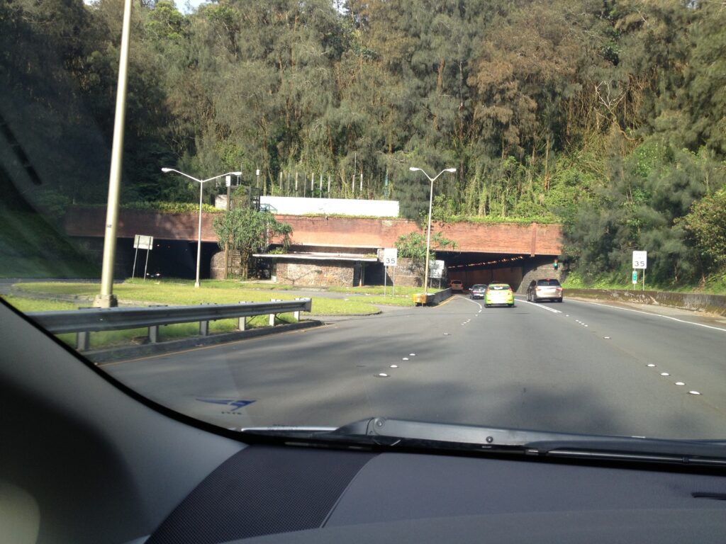
Wilson foresaw the growth on the windward side and excavation commenced on January 8, 1954 on the “Kalihi Tunnel.”  Near the end of May 1954 tunnel excavation transitioned from rock to “earth” – in the summer of 1954, several tunnel collapses and surface sinkholes subsequently led to a large collapse on August 14 that killed five construction workers.

Construction ceased while they considered alternative methods of completion.  Tunnel excavation restarted in February 1956 and the first half-mile tunnel was open to two-way traffic in 1958; both tunnels were fully operational by November 1960.

Initially known as the ‘Kalihi Tunnel,’ and often called the Likelike Tunnels, they are named in honor of John H Wilson.  (1998 brought the completion of H-3 (and the Tetsuo Harano Tunnels – named after a longtime state highways administrator.))

In addition to the John H Wilson Tunnels, the John H Wilson Elementary School on Kilauea Avenue and the adjoining Wilson Playground at Papakōlea in Waiʻalae Nui Valley are named for Wilson.

Johnny Wilson passed away on July 2, 1956 at the age of 84.

© 2022 Hoʻokuleana LLC

Filed Under: Prominent People Tagged With: Johnny Wilson, Yokohama, Joe Fern, Likelike Highway, Hawaii, Paoakalani, Waikiki, Honolulu, Oahu, Liliuokalani, Pali, Wilson Tunnel

  • « Previous Page
  • 1
  • …
  • 193
  • 194
  • 195
  • 196
  • 197
  • …
  • 562
  • Next Page »

Images of Old Hawaiʻi

People, places, and events in Hawaiʻi’s past come alive through text and media in “Images of Old Hawaiʻi.” These posts are informal historic summaries presented for personal, non-commercial, and educational purposes.

Info@Hookuleana.com

Connect with Us

  • Email
  • Facebook
  • LinkedIn
  • Twitter
  • YouTube

Recent Posts

  • “Pele’s Grandson”
  • Bahá’í
  • Carriage to Horseless Carriage
  • Fire
  • Ka‘anapali Out Station
  • Lusitana Society
  • “Ownership”

Categories

  • Place Names
  • Prominent People
  • Schools
  • Sailing, Shipping & Shipwrecks
  • Economy
  • Voyage of the Thaddeus
  • Mayflower Summaries
  • American Revolution
  • General
  • Ali'i / Chiefs / Governance
  • Buildings
  • Missionaries / Churches / Religious Buildings
  • Hawaiian Traditions
  • Military

Tags

Albatross Al Capone Ane Keohokalole Archibald Campbell Bernice Pauahi Bishop Charles Reed Bishop Downtown Honolulu Eruption Founder's Day George Patton Great Wall of Kuakini Green Sea Turtle Hawaii Hawaii Island Hermes Hilo Holoikauaua Honolulu Isaac Davis James Robinson Kamae Kamaeokalani Kamanawa Kameeiamoku Kamehameha Schools Lalani Village Lava Flow Lelia Byrd Liliuokalani Mao Math Mauna Loa Midway Monk Seal Northwestern Hawaiian Islands Oahu Papahanaumokuakea Marine National Monument Pearl Pualani Mossman Queen Liliuokalani Thomas Jaggar Volcano Waikiki Wake Wisdom

Hoʻokuleana LLC

Hoʻokuleana LLC is a Planning and Consulting firm assisting property owners with Land Use Planning efforts, including Environmental Review, Entitlement Process, Permitting, Community Outreach, etc. We are uniquely positioned to assist you in a variety of needs.

Info@Hookuleana.com

Copyright © 2012-2024 Peter T Young, Hoʻokuleana LLC


Loading Comments...