Images of Old Hawaiʻi

  • Home
  • About
  • Categories
    • Ali’i / Chiefs / Governance
    • American Protestant Mission
    • Buildings
    • Collections
    • Economy
    • Missionaries / Churches / Religious Buildings
    • General
    • Hawaiian Traditions
    • Other Summaries
    • Mayflower Summaries
    • Mayflower Full Summaries
    • Military
    • Place Names
    • Prominent People
    • Schools
    • Sailing, Shipping & Shipwrecks
    • Voyage of the Thaddeus
  • Collections
  • Contact
  • Follow

January 23, 2020 by Peter T Young 1 Comment

Old Plantation

Curtis Ward was born in Kentucky and arrived in Hawaiʻi in 1853, when whaling in the Pacific was at its peak. Curtis worked at the Royal Custom House, which monitored commercial activity at Honolulu Harbor for the kingdom.

Victoria Robinson was born in Nu’uanu in 1846, the daughter of English shipbuilder, James Robinson and his wife Rebecca, a woman of Hawaiian ancestry whose chiefly lineage had roots in Kaʻū, Hilo and Honokowai, Maui.

Ward started a livery with headquarters on Queen Street and expanded into the business of transporting cargo on horse-pulled wagons. The size of Ward’s work force became just as big as the harbor’s other major player, James Robinson & Co. (Victoria’s father.)

When tensions began to rise between the American North and South in the late-1850s, Ward would defend his Southern heritage. As a result, Ward’s home, named “Dixie,” was often stoned by Northern sailors. (Hustace)

Curtis and Victoria married in 1865 and for many years they made their home near Honolulu Harbor on property presently occupied by the Davies Pacific Center.

Seven daughters were born during these years: Mary Elizabeth, Kulamanu, May, Einei, Lucy, Kathleen and Lani.

As was common for many young married couples of English and Hawaiian ancestry during this period, the Wards socialized comfortably with Honolulu’s expatriate British families, as well as with members of the various Royal families.

This was a period of considerable turbulence in Hawaiian political affairs, and Curtis and Victoria joined with their friends in resisting the rising power of the sugar barons and firmly opposed reciprocity with the United States. (Ward Centers)

Even in later years, Victoria Ward held to her political convictions and remained a loyal friend and supporter of Liliʻuokalani after the overthrow of the monarchy in 1893. (Ward Centers)

Then, the Wards bought land on what was then the outskirts of Honolulu, eventually acquiring over 100-acres of land running from Thomas Square on King Street down to the ocean.

They built the “Old Plantation” in 1882, a stately, Southern-style home on the mauka portion of the property. It featured an artesian well, vegetable and flower gardens, a large pond stocked with fish, and extensive pasturage for horses and cattle. Self-sufficient as a working farm, Old Plantation was surrounded by a vast coconut grove.

In 1882, Curtis Ward died at age 53, leaving Victoria to raise seven daughters and manage the estate.

The Blaisdell Center has been in operation since 1964 and in 1994 was remodeled and expanded. The Blaisdell Center complex includes a multi-purpose Arena, Exhibition Hall, Galleria, Concert Hall, meeting rooms and parking structure.

In 2002, Chicago-based General Growth Properties Inc (owner of Ala Moana Center) closed on an agreement to buy Victoria Ward Ltd., giving it control of one of the state’s largest private landowners and operator of a growing retail complex in Kakaʻako.

In 2010, General Growth spun off its development properties as the Howard Hughes Corporation and is working on plans for the creation/redevelopment of an urban master planned community in Kakaʻako. (OHA and Kamehameha Schools are other large landowners in Kakaʻako.)

Follow Peter T Young on Facebook 

Follow Peter T Young on Google+ 

Follow Peter T Young on LinkedIn  

Follow Peter T Young on Blogger

© 2020 Hoʻokuleana LLC

  • 19580108 – Ward Estate (looking out driveway toward King Street. The daughters of Curtis P. Ward, gentleman from Kentucky who built Old Plantation, once romped on this lanai. SB BW by Terry Luke.
  • OLYMPUS DIGITAL CAMERA

Filed Under: Prominent People, Buildings Tagged With: Hawaii, James Robinson, Oahu, Kakaako, Victoria Ward, Blaisdell Center, Honolulu International Center, Old Plantation, Neal Blaisdell

January 6, 2020 by Peter T Young 1 Comment

Hawaiian Tuna Packers

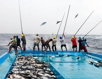
In lawaiʻa hi aku (fishing for aku,) “the slapping of the fish against the men’s sides and the arching of the bamboo poles as the aku bent them were like a double rainbow or the crescent shape of the moon of Hoaka.” (Maly)

A special canoe was used that served as a live bait well (malau,) it was joined by a double hulled canoe for the fishers (kaulua;) following the noio birds to the schooling aku, several canoes would form around them and the live bait released – then the lines of the bamboo fishing poles were cast. (Maly)

When the fish took the bait and broke water, the fisherman stood up straight and grasped the pole with both hands. The fish came completely out of the water and slapped against the side of the fisherman, who then shoved the aku forward in the canoe and cast again. (Maly)

In 1899, Gorokichi Nakasugi, a Japanese shipwright, brought a traditional Japanese sailing vessel, called a sampan, to Hawai‘i, and this led to a unique class of vessels and distinctive maritime culture associated with the rise of the commercial fishing industry in Hawai‘i. (Cultural Surveys)

The Japanese technique of catching tuna with pole-and-line and live bait resembled the aku fishing method traditionally used by Hawaiians. The pole-and-line vessels mainly targeted skipjack tuna (aku.)

In the modern fleet, with an average length of 75- to 90-feet, these boats were the largest of the sampans. The pole-and-line fleet generally fished within a few miles of the main Hawaiian Islands, because few vessels carried ice and the catch needed to be landed within four to five hours from the time of capture.

The modern fishing method used live bait thrown from a fishing vessel to stimulate a surface school into a feeding frenzy. Fishing was then conducted frantically to take advantage of the limited time the school remains near the boat.

The pole and line were about 10-feet and used a barbless hook with feather skirts which is slapped against the water until a fish strikes. Then the fish is yanked into the vessel in one motion. The fish unhooks when the line is slacked so that the process can be repeated.

On a pole-and-line vessel a fisherman was required to learn how to cast the line, jerk the fish out of the water, catch the tuna under his left arm, snap the barbless hook out, slide the fish into the hold and cast the line back out – all in rapid succession.

The fishery was dependent on having sufficient bait fish, nehu (Hawaiian anchovy;) a lot of the bait fish, came from Kāneʻohe Bay. Dozens of aku boats would set their nets in the Bay’s shallows; the pier at Heʻeia Kea Boat Harbor was homeport for more than 20 of them.

Initially, most sampans docked in Honolulu Harbor. In the 1920s, Kewalo Basin was constructed and by the 1930s was the main berthing area for the sampan fleet and also the site of the tuna cannery, fish auction, shipyard, ice plant, fuel dock and other shore-side facilities.

The Hawaiʻi skipjack tuna fishery originally supplied only the local market for fresh and dried tuna. Then, the Hawaiian Tuna Packers, Ltd. cannery was established (in 1916,) enabling the fishery to expand beyond a relatively small fresh and dried market.

Six sampans made up the cannery’s initial fleet. The fleet grew and before WWII the fishery included up to 26 vessels. Following the war, as new vessels were built, fleet size increased to a maximum of 32 vessels in 1948.

These vessels carried crews of 7-9 fishermen, and frequently worked 6 days a week. It was hard work and the fishing day may begin with catching bait fish at dawn, followed by fishing to dusk.

Historically, the pole-and-line, live bait fishery for skipjack tuna (aku) was the largest commercial fishery in Hawaiʻi. Annual pole-and-line landings of skipjack tuna exceeded 5.5 million lb from 1937 to 1973.

The new and expanding market for canned product allowed the fishery to grow; from 1937 until the early 1980s most of the skipjack tuna landed in Hawaiʻi was canned.

F Walter Macfarlane opened the Macfarlane Tuna Company at Ala Moana and Cooke street. By 1922, after having changed hands a couple times, the company was incorporated by local stockholders as Hawaiian Tuna Packers Ltd.

Around 1928, tuna processing started in Kewalo Basin. Nearby was the Kewalo Shipyard that serviced and repaired the local aku boats. They also had an ice house.

From the beginning, Hawaiian Tuna Packers label was Coral Tuna or Coral Hawaiian Brand Tuna.

By the 1930s, the Honolulu cannery employed 500 and produced nearly ten-million cans of tuna per year. For several years Hawaiian Tuna Packers also operated a smaller cannery in Hilo.

About ninety percent of the output was shipped to the mainland; the remaining ten percent was sold in Hawaiʻi. (The cans for packing the tuna are furnished by the Dole Company.)

Fishing stopped during WWII because the larger sampans were used by the military for patrol duties and the Japanese fishermen were not allowed to go to sea. (Wilson)

With the entry of the United States in the Second World War came the imposition of area and time restrictions on fishing activities in Hawai’i that virtually eliminated offshore harvesting operations. Many fishing boats were requisitioned by the Army or Navy. (Schug)

The tuna cannery was converted into a plant for the assembly of airplane auxiliary fuel tanks and the shipyard was converted to the maintenance of military craft. Hawaiʻi’s fishing industry was forever changed. (Schug)

In 1960, Castle & Cooke bought out Hawaiian Tuna Packers and made it a part of Bumble Bee Seafoods out of the northwest. They operated the cannery until late-1984, when it ultimately closed.

Follow Peter T Young on Facebook 

Follow Peter T Young on Google+ 

Follow Peter T Young on LinkedIn  

Follow Peter T Young on Blogger

© 2020 Hoʻokuleana LLC

  • OLYMPUS DIGITAL CAMERA
  • In the late 1930s, Kewalo Basin was filled with sampan fishermen

Filed Under: Economy, Sailing, Shipping & Shipwrecks Tagged With: Hawaii, Sampan, Kewalo, Kakaako, Hawaiian Tuna Packers, Fishing, Aku

January 3, 2020 by Peter T Young 1 Comment

Fort Armstrong

Fort Armstrong was located at Honolulu and was built on fill over Kaʻākaukukui reef in 1907 to protect Honolulu Harbor. It had one named Battery, and was spread over an area of 64.34 acres (6 acres being upland and the balance submerged lands.)

Kaʻākaukukui (the right (or north) light – and also called ‘Ākaukukui) was an original name for Kakaʻako.

Marshland, reef, salt pans and traditional fish ponds existed in this area. The entire shoreline was a coral wasteland bordered by mudflats. According to an 1885 survey map, the ‘ili of Kaʻākaukukui was awarded by land court to Victoria Kamāmalu; Princess Bernice Pauahi Bishop inherited the land and it later became part of the Kamehameha Schools.

In 1898, the property was transferred to the United States by the Republic of Hawaiʻi under the joint resolution of annexation and, to protect the mouth of Honolulu Harbor, the US Army filled a submerged coral reef on the ‘Ewa side of Ka’ākaukukui for a gun emplacement.

In January 1905, President Teddy Roosevelt instructed Secretary of War William H Taft to convene the National Coast Defense Board (Taft Board) “to consider and report upon the coast defenses of the United States and the insular possessions (including Hawai‘i.)”

In 1906 the Taft Board recommended a system of Coast Artillery batteries to protect Pearl Harbor and Honolulu. Between 1909-1921, the Hawaiian Coast Artillery Command had its headquarters at Fort Ruger and defenses included artillery regiments stationed at …

… Fort Armstrong, Fort Barrette, Fort DeRussy, Diamond Head, Fort Kamehameha, Kuwa‘aohe Military Reservation (Fort Hase – later known as Marine Corps Base Hawaiʻi) and Fort Weaver.

The District was renamed Headquarters Coast Defenses of Oʻahu sometime between 1911 and 1913. Following World War I and until the end of World War II, additional coastal batteries were constructed throughout the Island.

Fort Armstrong, built in 1907, was named for Brigadier General Samuel C Armstrong. His father, Reverend Richard Armstrong (1805-1860,) had arrived in Hawaiʻi in 1832 and later replaced Hiram Bingham as pastor at Kawaiahaʻo Church (1840-1843.) In 1848, Armstrong (the father) left the mission and became Hawaiʻi’s minister of public education.

Armstrong (the son – namesake of the Fort) was born January 30, 1839 in Maui, Hawaii, the sixth of ten children. He attended Punahou School and later volunteered to serve in the Union Army during the American Civil War.

At the end of the war, Armstrong established the Hampton Normal and Agricultural Institute – now known as Hampton University – in Hampton, Virginia in 1868. Perhaps the best student of Armstrong’s Hampton-style education was Booker T Washington. Samuel Chapman Armstrong died at the Hampton Institute on May 11, 1893, and is buried in the Hampton University Cemetery.

The original garrison at Fort Armstrong was the 1st Coast Artillery Company, followed by the 104th Mine Co. operating the harbor mines. Also stationed there was the 185th Coast Artillery Company.

They lived in tents for quite a long time; then temporary barracks were built – wooden structures that were continually occupied since January, 1914. Buildings are constructed of 1 x 12 rough boards, with tar-paper roofs.

The facility later had a barracks, 4 officers’ quarters, 3 noncommissioned officers’ quarters, administration building and post exchange, guardhouse, fire apparatus house, quartermaster storehouse, gymnasium and related infrastructure; the standard strength was 109 men.

Battery Tiernon at Fort Armstrong was armed with two pedestal mounted 3-inch Guns from 1911 to 1943.

The first service practice ever held at Battery Tiernon, using the 3-inch guns, was August 30, 1913. “Two 10-by-24 foot material targets were towed from right to left, facing the field of fire from a position at the B.C. station. … only one target was fired upon, viz: Four shots by the first manning detail and then four shots by the second manning detail. This was due to the fact that when the left target had almost reached the inner allowable limit of range at which practice may be held (1,500-yards) the right target was just beginning to be obscured by a dredge working in the outer channel.”

The Army mission in Hawaiʻi was defined in 1920 as “the defense of Pearl Harbor Naval Base against damage from naval or aerial bombardment or by enemy sympathizers and attack by enemy expeditionary force or forces, supported or unsupported by an enemy fleet or fleets.”

Fort Armstrong continued under the Coast Artillery program until September 15, 1922.

It was reserved for military purposes by a series of Executive Orders in 1930 and was described as the Fort Armstrong Military Reservation.

The present seawall was constructed 500-feet out from the original shoreline in 1948, and the area was backfilled. The Army Corps of Engineers took over the post in 1949. Kakaʻako Park was created over the landfill area.

On December 13, 1951, because the site was no longer needed by the military and was needed by the Territory of Hawaiʻi for harbor improvements, President Truman transferred the land to the Territory of Hawaiʻi.

Today, the site includes Piers 1 and 2 and has container and general cargo berths, warehouses, sheds, open paved storage areas for container back up and marshaling and Foreign Trade Zone No. 9. The area also contains the US Immigration Station, the Department of Health Building, and the Ala Moana Pumping Station (all historic buildings.)

Follow Peter T Young on Facebook 

Follow Peter T Young on Google+ 

Follow Peter T Young on LinkedIn  

Follow Peter T Young on Blogger

© 2020 Hoʻokuleana LLC

Filed Under: Military Tagged With: Army Coast Artillery Corps, Kawaiahao Church, Richard Armstrong, Samuel Armstrong, Kakaako, Kaakaukukui, Battery Tiernon, Fort Armstrong, Hawaii, Oahu

November 5, 2019 by Peter T Young Leave a Comment

21-Gun Salute

The tradition of rendering a salute by cannon originated in the 14th century as firearms and cannons came into use. Since these early devices contained only one projectile, discharging them rendered them harmless.

Initially, the tradition began as a custom among ships, whose captains had volleys fired upon entering a friendly port to release its arsenal, which demonstrated their peaceful intentions (by placing their weapons in a position that rendered them ineffective.)

This custom was eventually adopted by the British navy whose ships fired seven-gun salutes, choosing the number seven because it was thought to be the luckiest of the odd numbers.

And, it was thought seven was also selected because of its astrological and Biblical significance. Seven planets had been identified and the phases of the moon changed every seven days.

The Bible states that God rested on the seventh day after Creation, that every seventh year was sabbatical and that the seven times seventh year ushered in the Jubilee year.

Land batteries, having a greater supply of gunpowder, were able to fire three guns for every shot fired afloat, hence the salute by shore batteries was 21 guns.

As time went on, gun salutes continued to be fired in odd numbers, due to the fact that ancient superstitions held that uneven numbers were lucky. (Even as far back as 1865, firing of an even number of guns in salute was taken as an indication that a ship’s captain, master or master gunner had died on the voyage.)

The US Navy regulations for 1818 were the first to prescribe a specific manner for rendering gun salutes (although gun salutes were in use before the regulations were written down).

Those regulations required that “When the President shall visit a ship of the United States’ Navy, he is to be saluted with 21 guns.” (It may be noted that 21 was the number of states in the Union at that time.)

For a time thereafter, it became customary to offer a salute of one gun for each state in the Union, although in practice there was a great deal of variation in the number of guns actually used in a salute.

After 1841, it was customary for a US president to receive a 21-gun salute, with the vice president receiving 17. Today, however, the vice president receives 19.

On Aug. 18, 1875, Great Britain and the United States announced an agreement to return salutes, “gun for gun,” making the 21-gun salute the highest national honor.

In 1890, regulations designated the “national salute” as 21 guns and redesignated the traditional Independence Day salute, the “Salute to the Union,” equal to the number of states. Fifty guns are also fired on all military installations equipped to do so at the close of the day of the funeral of a President, ex-President, or President-elect.

The 21-gun salute became the highest honor a nation rendered.

Today, the national salute of 21 guns is fired in honor of a national flag, the sovereign or chief of state of a foreign nation, a member of a reigning royal family, and the President, ex-President and President-elect of the United States.    (Senator Daniel Inouye was given a 19-gun cannon salute.)

It is also fired at noon of the day of the funeral of a President, ex-President or President-elect, on Washington’s Birthday, Presidents Day and the Fourth of July. On Memorial Day, a salute of 21 minute guns is fired at noon while the flag is flown at half-mast.

In Hawaiʻi, “King Kalākaua, the Queen, and the national flag were accorded a 21-gun salute, an ambassador extraordinary and plenipotentiary rated 19 guns, a governor or high commissioner 17, an admiral of the fleet 15, a minister resident 13, a charge d’affaires 11, a consul general nine, and a consul seven.”  (Schwieizer)

While King Lunalilo was on his deathbed, he requested a burial at Kawaiahaʻo Church, with his mother on the church’s ground. He wanted, he said, to be “entombed among (my) people, rather than the kings and chiefs” at Mauna ʻAla (Royal Mausoleum) in Nuʻuanu Valley.

Lunalilo died February 3, 1874; during his funeral procession, eyewitnesses reportedly stated that a sudden storm arose, and that twenty-one rapid thunderclaps echoed across Honolulu which came to be known as the “21-gun salute.” (RoyalOrderOfKamehamehaI-org)

While the sum of the digits in 1776 adds up to 21, reportedly there is no historical link to the year of our nation’s signing of the Declaration of Independence and the 21-gun salute.

Follow Peter T Young on Facebook 

Follow Peter T Young on Google+ 

Follow Peter T Young on LinkedIn  

Follow Peter T Young on Blogger

© 2019 Hoʻokuleana LLC

21-Gun-Kaka‘ako Saluting Battery and flagstaff-(Hammatt)-1887
Cannon_fires_at_Annexation_of_Hawaii-1898
090915-N-9824T-227 YORK, Pa. (Sept. 15, 2009) Seaman Sarah Rickett, assigned to USS Constitution, demonstrates how Sailors in the past would prepare a cannon for firing. The gun drill demonstration by the Constitution crew was one of many Navy events scheduled during York Navy Week, one of 21 Navy Weeks planned across America in 2009. Navy Week is designed to show Americans the investment they have made in their Navy and increase awareness in metropolitan areas that do not have a significant Navy presence. (U.S. Navy photo by Mass Communication Specialist 2nd Class Devin Thorpe/Released)
Soldiers-honoring-general-george-s-patton-jr-during-his-funeral-with-a-gun-salute
Presidio-Salute
‘Tropic Lightning’ welcomes its new commander-25thID_ChangeOFCommand-(Army)
031207-N-5024R-087 Pearl Harbor, Hawaii (Dec. 7, 2003) Ð Members of the U.S. Marine Corps Rifle Detail perform a 21-gun salute during the 62nd Pearl Harbor Anniversary ceremony of the attack on Pearl Harbor, held aboard the USS Arizona Memorial. More than 250 distinguished visitors and veterans were expected to attend the ceremony which also included the guided missile destroyer USS OÕKane (DDG 77) rendering honors, more than 40 wreath presentations, a 21-gun salute and the playing of taps. The Guest Speaker was Commander, U. S. Pacific Command, Adm. Thomas B. Fargo. U.S. Navy photo by Photographer's Mate 2nd Class Johnnie R. Robbins. (RELEASED)
031207-N-5024R-087 Pearl Harbor, Hawaii (Dec. 7, 2003) Ð Members of the U.S. Marine Corps Rifle Detail perform a 21-gun salute during the 62nd Pearl Harbor Anniversary ceremony of the attack on Pearl Harbor, held aboard the USS Arizona Memorial. More than 250 distinguished visitors and veterans were expected to attend the ceremony which also included the guided missile destroyer USS OÕKane (DDG 77) rendering honors, more than 40 wreath presentations, a 21-gun salute and the playing of taps. The Guest Speaker was Commander, U. S. Pacific Command, Adm. Thomas B. Fargo. U.S. Navy photo by Photographer’s Mate 2nd Class Johnnie R. Robbins. (RELEASED)
ARLINGTON, VA - JULY 13: A firing party fires a 21 gun salute during a funeral service for U.S. Army Maj. Paul Syverson at Arlington National Cemetary July 13, 2004 in Arlington, Virginia. Syverson was killed June 16 when he stopped to buy equipment at the PX at a U.S. base north of Baghdad. When CIA agent Johnny Mike Spann was killed in an Afghanistan prison uprising, Syverson was one of the special forces commandos sent in to retrieve his body and curtail the intense fighting. (Photo by Mark Wilson/Getty Images)
ARLINGTON, VA – JULY 13: A firing party fires a 21 gun salute during a funeral service for U.S. Army Maj. Paul Syverson at Arlington National Cemetary July 13, 2004 in Arlington, Virginia. Syverson was killed June 16 when he stopped to buy equipment at the PX at a U.S. base north of Baghdad. When CIA agent Johnny Mike Spann was killed in an Afghanistan prison uprising, Syverson was one of the special forces commandos sent in to retrieve his body and curtail the intense fighting. (Photo by Mark Wilson/Getty Images)
A cannon salute is fired at the change of command ceremony
Third Marine Regiment Honors Fallen Heroes
US Navy sailors give a 21-gun salute-Pearl_Harbor
Don_Ho-Water_Cannon_Salute-(honoluluadvertiser)
Hawaiian_Airlines_Jet-Water_Cannon_Salute
Downtown and Vicinity-Map-1887-noting_Kakaako_Saluting_Battery

Filed Under: Military Tagged With: Kakaako, 21-gun, Hawaii

November 2, 2019 by Peter T Young Leave a Comment

Transformation of Ala Moana Coastline

The coastal road from Honolulu Harbor to Waikīkī, formerly called the “Beach Road” and renamed “Ala Moana” in 1899, hugged the shoreline with extensive reefs out into the ocean; mauka of the road were wetlands and aquaculture with fishponds, kalo (taro) and, later, rice.

This stretch of coastline was described by missionary Hiram Bingham, as he stood atop “Punchbowl Hill” looking toward Waikīkī to the south, as the “plain of Honolulu” with its “fishponds and salt making pools along the seashore”. (Bingham)

Another visitor to Honolulu in the 1820s, Capt. Jacobus Boelen, gives similar insight to the possible pre-contact character of the area:  “It would be difficult to say much about Honoruru (Honolulu.) On its southern side is the harbor or the basin of that name.”

“The landlocked side in the northwest consists mostly of tarro (kalo, taro) fields. …  From the north toward the east, where the beach forms the bight of Whytetee (Waikīkī,) the soil around the village is less fertile, or at least not greatly cultivated.” (Cultural Surveys)

At the beginning of the twentieth-century, this stretch of coast makai of Ala Moana Boulevard was the site of the Honolulu garbage dump, which burned almost continually.  The residue from burned rubbish was used to reclaim neighboring wetlands (which later were more commonly referred to as “swamp lands.”)

After the turn of the century and over the next several decades, channels and basins were dredged in the fringing reefs to obtain fill material, for navigation, for small craft harbors and for swimming and sea bathing.

“Nature, situation and human circumstance fix world-wide prominence and importance on certain strategic points in commerce, navigation and defense. Human events have moved slowly, but are becoming intensely accelerated, and it would seem Honolulu is now beginning to fulfil her destiny.” So said Mr. LE Pinkham, President of the Board of Health in 1906.

With his report, he recommended filling in the wetlands from downtown Honolulu to Waikīkī and noted, “To install an adequate sewer system and proper surface drainage … (the area) under consideration, requires to be raised to a grade ranging from five to seven feet above sea level. Neither the hills mauka nor the beach can physically or economically furnish the material.”

Shortly thereafter (1912,) the Sanitary Commission in its report to Governor Frear noted, “The low lands along the sea front of six miles are largely swamps. Wherever profitable they are used for wet agriculture, and the area of wet land has been enlarged until it is difficult now to distinguish between them, nor can the source of water in the swamps be determined except by survey; much of it is water from irrigation. The total area of wet land is 36 per cent, of the land below the foothills.”

Like Pinkham, the Sanitary Commission stated, “It is obvious that all swamps and low lands which may become swamps should be filled or otherwise reclaimed, in order that their ever-present menace to health shall be entirely and finally removed.”  This led to a variety of projects that changed the look, nature and use of the region.

The first efforts were concentrated at Kakaʻako – it was then more generally referred to as “Kewalo.”  The Kewalo Reclamation District included the area bounded by South Street, King Street, Ward Avenue and Ala Moana Boulevard.

In 1899, the first traditional Japanese sailing vessel, called a sampan, came to Hawai‘i.  The Japanese technique of catching tuna with pole-and-line and live bait resembled the aku fishing method traditionally used by Hawaiians.  The pole-and-line vessels mainly targeted skipjack tuna (aku.)

Initially, most sampans docked in Honolulu Harbor. In the 1920s, Kewalo Basin was constructed and by the 1930s was the main berthing area for the sampan fleet and also the site of the tuna cannery, fish auction, shipyard, ice plant, fuel dock and other shore-side facilities.

Later in the 1920s, a channel parallel to the coast was dredged through the coral reef to connect Kewalo Basin and Ala Wai Boat Harbor, so boats could travel between the two.  Part of the dredge material helped to reclaim swampland on the ʻEwa end of Waikīki that was filled in with dredged coral.

The City and County of Honolulu started cleaning up the Ala Moana area in 1931. Using funds from President Franklin Delano Roosevelt’s New Deal Project a city park was created – filling in the swamp and garbage dump with coral rubble, topping it with sand. President Roosevelt participated in the dedication of the new 76-acre “Moana Park” in 1934 (it was later renamed Ala Moana Park in 1947.)

In 1944 the Territorial Department of Public Works proposed that an airport for private flying be created by a combined coral dredging and fill project on the reef between downtown Honolulu and the Waikīkī section of the city.  A Master Plan for Ala Moana Airport was approved by the federal agencies as part of the 1947 National Airport Plan. The runway was to be located makai of Ala Moana Park on the fringing reef and consist of a single runway 3,000 feet by 75 feet.

In the mid-1950s, reef rubble was dredged to fill in the old navigation channel (between Kewalo and the Ala Wai); it was topped with sand brought from Keawaʻula Beach (Yokohama Beach (locally known as ‘Pray for Sex’)) in Waianae.  At the same time, a new swimming channel was dredged parallel to the new beach, extending about 400-feet offshore.

In 1958, a 20-page booklet was sent to Congress to encourage them to turn back Ala Moana Reef to the Territory of Hawaiʻi for the construction of a “Magic Island.”  Local businessmen and firms paid half the cost and the Territory paid half, through the Economic Planning & Coordination Authority.   (Honolulu Record, February 13, 1958)

The booklet put forth the argument that “Tourist development is our most important immediate potential for economic expansion,” and displays pictures of the crowded Waikīkī area to show the lack of room for expansion.  Then it directs the reader’s attention to land that can be reclaimed from the sea by utilizing reefs, especially the 300-acre area of Ala Moana reef.  (Honolulu Record, February 13, 1958)

With statehood (1959,) some considered the makai-most portion of filled-in area of Kakaʻako peninsula for the location for a new State capitol.  They settled on the present location, mauka of ʻIolani Palace.

In the early 1960s, substantial changes were made from the more extensive original plan for the Ala Moana reef; rather than multiple islands for several resort hotels built on the reef flat off of Ala Moana Park, a 30-acre peninsula, with “inner” and “outer” beaches for protected swimming, was constructed adjoining the Ala Wai Small Boat Harbor and Ala Wai Canal outlet.

The Magic Island peninsula was converted into a public park. In 1972 the State officially renamed Magic Island to ‘Āina Moana, or “land [from the] sea,” to recognize that the park is made from dredged coral fill. The peninsula was turned over the city in a land exchange and is formally known as the ‘Āina Moana Section of Ala Moana Beach Park, but local residents still call it Magic Island.

Follow Peter T Young on Facebook 

Follow Peter T Young on Google+ 

Follow Peter T Young on LinkedIn  

Follow Peter T Young on Blogger

© 2019 Hoʻokuleana LLC

Filed Under: Place Names, Economy Tagged With: Hawaii, Kewalo, Kakaako, Ala Wai, Ala Moana, Aina Moana

  • « Previous Page
  • 1
  • 2
  • 3
  • 4
  • 5
  • Next Page »

Images of Old Hawaiʻi

People, places, and events in Hawaiʻi’s past come alive through text and media in “Images of Old Hawaiʻi.” These posts are informal historic summaries presented for personal, non-commercial, and educational purposes.

Info@Hookuleana.com

Connect with Us

  • Email
  • Facebook
  • LinkedIn
  • Twitter
  • YouTube

Recent Posts

  • ‘Holy Moses’
  • Mikimiki
  • Doubtful Island of the Pacific
  • John Meirs Horner
  • Prostitution
  • Malukukui
  • Fight for Parker Ranch

Categories

  • Hawaiian Traditions
  • Military
  • Place Names
  • Prominent People
  • Schools
  • Sailing, Shipping & Shipwrecks
  • Economy
  • Voyage of the Thaddeus
  • Mayflower Summaries
  • American Revolution
  • General
  • Ali'i / Chiefs / Governance
  • Buildings
  • Missionaries / Churches / Religious Buildings

Tags

Albatross Al Capone Ane Keohokalole Archibald Campbell Bernice Pauahi Bishop Charles Reed Bishop Downtown Honolulu Eruption Founder's Day George Patton Great Wall of Kuakini Green Sea Turtle Hawaii Hawaii Island Hermes Hilo Holoikauaua Honolulu Isaac Davis James Robinson Kamae Kamaeokalani Kamanawa Kameeiamoku Kamehameha Schools Lalani Village Lava Flow Lelia Byrd Liliuokalani Mao Math Mauna Loa Midway Monk Seal Northwestern Hawaiian Islands Oahu Papahanaumokuakea Marine National Monument Pearl Pualani Mossman Queen Liliuokalani Thomas Jaggar Volcano Waikiki Wake Wisdom

Hoʻokuleana LLC

Hoʻokuleana LLC is a Planning and Consulting firm assisting property owners with Land Use Planning efforts, including Environmental Review, Entitlement Process, Permitting, Community Outreach, etc. We are uniquely positioned to assist you in a variety of needs.

Info@Hookuleana.com

Copyright © 2012-2024 Peter T Young, Hoʻokuleana LLC


Loading Comments...