Images of Old Hawaiʻi

  • Home
  • About
  • Categories
    • Ali’i / Chiefs / Governance
    • American Protestant Mission
    • Buildings
    • Collections
    • Economy
    • Missionaries / Churches / Religious Buildings
    • General
    • Hawaiian Traditions
    • Other Summaries
    • Mayflower Summaries
    • Mayflower Full Summaries
    • Military
    • Place Names
    • Prominent People
    • Schools
    • Sailing, Shipping & Shipwrecks
    • Voyage of the Thaddeus
  • Collections
  • Contact
  • Follow

April 16, 2025 by Peter T Young Leave a Comment

Kepuwahaʻulaʻula

“(S)everal islands were ruled by independent kings, who were frequently at war with each other, but more often with their own subjects. As one chief acquired sufficient strength, he disputed the title of the reigning prince.”

“If successful, his chance of permanent power was quite as precarious as that of his predecessor. In some instances the title established by force of arms remained in the same family for several generations, disturbed, however, by frequent rebellions … war being a chief occupation …”  (Jarves)

At the period of Captain Cook’s arrival (1778-1779), the Hawaiian Islands were divided into four kingdoms: (1) the island of Hawaiʻi under the rule of Kalaniʻōpuʻu, who also had possession of the Hāna district of east Maui; (2) Maui (except the Hāna district,) Molokai, Lānai and Kahoʻolawe, ruled by Kahekili; (3) Oʻahu, under the rule of Kahahana; and (4) Kauai and Niʻihau, Kamakahelei was ruler.

“At that time Kahekili was plotting for the downfall of Kahahana and the seizure of Oʻahu and Molokai, and the queen of Kauai was disposed to assist him in these enterprises. The occupation of the Hāna district of Maui by the kings of Hawaiʻi had been the cause of many stubborn conflicts between the chivalry of the two islands.”  (Kalākaua)

Following Kalaniʻōpuʻu’s death in 1782, the Hawaiʻi Island kingship was inherited by his son Kīwalaʻō; Kamehameha (Kīwalaʻō’s cousin) was given guardianship of the Hawaiian god of war, Kūkaʻilimoku.  Dissatisfied with subsequent redistricting of the lands by district chiefs, civil war ensued between Kīwalaʻō’s forces and the various chiefs under the leadership of Kamehameha.

In the first major skirmish, in the battle of Mokuʻōhai (a fight between Kamehameha and Kiwalaʻo in July, 1782 at Keʻei, south of Kealakekua Bay on the Island of Hawaiʻi,) Kiwalaʻo was killed.

With the death of his cousin Kiwalaʻo, the victory made Kamehameha chief of the districts of Kona, Kohala and Hāmākua, while Keōua, the brother of Kiwalaʻo, held Kaʻū and Puna, and Keawemauhili declared himself independent of both in Hilo.  (Kalākaua)

Back on Maui, Kahekili prepared for an invasion against Oʻahu and Kahahana.  He landed at Waikīkī in the beginning of 1783.  Kahekili, dividing his forces in three columns, marched from Waikīkī by Pūowaina (Punchbowl,) Pauoa and Kapena to battle Kahahana and his forces.

Kahahana’s army was routed, and he and his wife fled to the mountains.  For nearly two years or more they wandered over the mountains, secretly aided, fed and clothed by his supporters.  Kahekili’s warriors finally found and killed Kahahana.

In 1790, Kamehameha moved to take Maui – heading first to Hāna.  Hearing this, Kahekili sent Kalanikūpule back to Maui with a number of chiefs (Kahekili remaining on O‘ahu to maintain order of his newly conquered kingdom.)

Helping Kamehameha were foreigners, John Young and Isaac Davis.  John Young, a boatswain on the British fur trading vessel, Eleanora, had been stranded on the Island of Hawai‘i in 1790.  Because of his knowledge of European warfare, Young is said to have trained Kamehameha and his men in the use of muskets and cannons.

Isaac Davis arrived in Hawaii in 1790 as the sole survivor of the massacre of the crew of The Fair American.  Davis also brought western military knowledge; Young and Davis fought alongside Kamehameha in his battles.

Kahekili’s brother, Kamehamehanui (uncle to Kamehameha I,) lost Hāna, which was isolated from the rest of Maui.  Kamehameha then landed at Kahului and marched on to Wailuku, where Kalanikūpule waited for him.

The ensuing battle was one of the hardest contested on Hawaiian record.  The battle started in Wailuku and then headed up ‘l̄ao Valley – the Maui defenders being continually driven farther up the valley.

Kamehameha’s superiority in the number and use of the newly acquired weapons and canon (called Lopaka) from the ‘Fair American’ (used for the first time in battle, with the assistance from Young and Davis) finally won the decisive battle at ‘Īao Valley.

The Maui troops were completely annihilated, and it is said that the corpses of the slain were so many as to choke up the waters of the stream of ‘l̄ao – one of the names of the battle was “Kepaniwai” (the damming of the waters.)

Maui Island was conquered and its fighting force was destroyed – Kalanikūpule and some other chiefs escaped over the mountain at the back of the valley and made their way to Molokai, then to O‘ahu.  With Kalanikūpule was Kalola, daughter of King Kekaulike, sister to Kahekili and aunt of Kalanikūpule.  Kalola was also grandmother to Keōpūolani.

Kamehameha followed Kalola to Molokai and made a “request that she (Kalola) should confide her daughters and granddaughter to his care and protection. To which Kalola is said to have replied, ‘When I am dead, my daughters and granddaughter shall be yours.’” (Fornander)

Kamehameha camped on Molokai until Kalola died.  This “capture” of the women by Kamehameha, a conquering chief taking the widow and female relatives of his defeated rival, was politically important.  Taking Keōpūolani as his new wife, Kamehameha returned to Hawaiʻi Island.

The abrupt departure of Kamehameha and his fleet from Molokai and his return to Hawaiʻi took a great weight off the mind of Kahekili, and plans of vengeance occupied his thoughts and brightened his vision in the immediate future. He was doubtless encouraged by Kāʻeokūlani, who by this time had obtained the supremacy of Kauai, and who urged his brother to avenge the defeat of Kalanikūpule.  (Fornander)

Negotiations and preparations having been perfected between the Kauai and Oʻahu sovereigns during the winter months of 1790-91, Kāʻeokūlani left Kauai with a well-equipped fleet of war canoes, accompanied by a foreign gunner Mare Amara and arrived at Oʻahu in the spring of 1791.  (Fornander)

Kahekili decided that no better time could be chosen to attack Kamehameha.  The chiefs had massed their forces on Maui. Here Kāʻeokūlani, took the leadership role.  After a little rest, the Kauai fleet swept across the channel and passed down the eastern side of Hawaiʻi.  They ransacked villages along the way.  Finally Kamehameha’s canoes and ships caught up with them off Waimanu, not far from Waipiʻo.

In former years a naval battle meant the clash of canoe against canoe.  This battle was different.

Unlike the prior battle at ʻĪao, here both sides had modern firearms and people who knew how to use them (this battle was the first in Hawaiʻi that saw both sides have foreign gunners, Mare Amara with Kahekili, and Isaac Davis and John Young with Kamehameha.)

The people on the bluffs saw the red flashes of the guns and noted the increasing noise of the artillery until they could no longer hear the voices of men. As the clouds of smoke crept over the sea the battle became, in the view of the watchers, a fight between red mouthed guns, and they shouted one to another the news of the progress of the conflict according to the predominance of flashing muskets and cannon.

It was soon seen that the invaders were being defeated. The man who had the best arms and the best gunners won the victory.  The Kauai and Oʻahu Chiefs fled with their scattered fleets to Maui.

Kamehameha soon followed them, and during the next three years, step by step, passed over the islands until the kingdom was his.  (Westervelt)

The battle was so fierce that it was called Kepuwahaʻulaʻula (the Battle of the Red-Mouthed Gun.)  The image depicting the battle is artwork by Herb Kane (Kamehameha is in the Fair American.)

© 2025 Hoʻokuleana LLC

Filed Under: Ali'i / Chiefs / Governance, Place Names Tagged With: Kahahana, Kaeo, Kahekili, Kalanikupule, Kepaniwai, Keopuolani, Kalaniopuu, Waimanu, Kalola, Hawaii, Kepuwahaulaula, Kamehameha, Battle of the Red-Mouth Gun, Iao, Kamakahelei

December 31, 2023 by Peter T Young Leave a Comment

Captain William Brown is Killed

A Post Script in a March 3, 1810 letter from Kamehameha to England’s King George III only starts to tell a story …

“PS. My removal from Owyhee to this Island was in consequence of their having put to death Mr. Brown & Mr. Gordon, Masters, (of the Jackall & Prince Le Boo, two of you [sic] merchant vessels.) I have sent by Mr. Jno. Gl Spence Commander of the Ship Duke of Portland, a feather’d cloak & beg your acceptance.”

Kamehameha had been on the Island of Hawai‘i and came to O‘ahu – what happened … ?

These were interesting and turbulent times.

At the time of Cook’s arrival (1778-1779), the Hawaiian Islands were divided into four kingdoms: (1) the island of Hawaiʻi under the rule of Kalaniʻōpuʻu, who also had possession of the Hāna district of east Maui; (2) Maui (except the Hāna district,) Molokai, Lānaʻi and Kahoʻolawe, ruled by Kahekili; (3) Oʻahu, under the rule of Kahahana; and at (4) Kauai and Niʻihau, Kamakahelei was ruler.

Following Kalaniʻōpuʻu’s death in 1782, the kingship was inherited by his son Kīwalaʻō; Kamehameha (Kīwalaʻō’s cousin) was given guardianship of the Hawaiian god of war, Kūkaʻilimoku.

Civil war broke out between Kīwalaʻō’s forces and the various chiefs under the leadership of Kamehameha. At the Battle of Mokuʻōhai (just south of Kealakekua) Kīwalaʻō was killed and Kamehameha gained control of half the Island of Hawaiʻi

On Maui, Kamehameha also battled Kahekili and Kalanikūpule’s forces at a battle at ʻIao (1790).  It was described, “They speak of the carnage as frightful, the din and uproar, the shouts of defiance among the fighters, the wailing of the women on the crests of the valley, as something to curdle the blood or madden the brain of the beholder.” (Fornander)

The Maui troops were completely annihilated and it is said that the corpses of the slain were so many as to choke up the waters of the stream of ʻlao, and that hence one of the names of this battle was “Kepaniwai” (the damming of the waters).  (Fornander)

Kamakahelei was the Queen of Kauai and Niʻihau, and her husband (Kāʻeokūlani (Kā‘eo) was a younger brother to Kahekili.  (With Kāʻeo, Kamakahelei had a son Kaumualiʻi.) Kahekili was plotting for the downfall of Kahahana and the seizure of Oʻahu and Molokai, and the queen of Kauai assisted him.

By 1791, Kahekili, King of Oahu, Molokai and Maui, was on Maui with his brother Kā‘eo, King of Kauai, preparing to resist the threatened invasion of Maui by Kamehameha of Hawai‘i.

Kahekili agreed with Kā‘eo that after his death Kā‘eo was to be regent of Maui and Molokai while Kalanikūpule, the son and heir of Kahekili, was to be King of Maui, Molokai, and Oahu, but was to reside on O‘ahu and allow Kā’eo to govern Maui and Molokai for him.

In 1793, Captain Brown was a British trader, “one of that numerous group of commercial adventurers who flocked into the north Pacific Ocean in the wake of Cook, drawn thither by the chance discovery, as one result of the last expedition led by that great navigator, of the possibilities of wealth in the fur trade between China and the coast of America.”  (Kuykendall)

Brown’s three-vessel trading squadron included the ‘Butterworth’ (under Captain Brown,) ‘Prince Lee Boo’ (under Captain Gordon) and the ‘Jackal’ (under the command of Captain Alexander Stewart.)

At Maui Captain Brown seems to have entered into some sort of a politico-commercial agreement with Kahekili. Brown “had left the Isld, only a fortnight before we arrived had given them a number of Muskets, a very large quantity of Powder, and two pieces of Cannon (4 pounders)”.  (Boit)

However, for these weapons, Boit says that Kahekili had “given to him the whole right & property of the Islands Woahoo (O‘ahu) & Atooi (Kauai)”.  Later, Kamakau notes Kalanikūpule bargained for Brown’s assistance for “four hundred hogs”.

In July 1794, Kahekili died and, according to the prior arrangement, Kalanikūpule took control of O‘ahu and Kā‘eo ruled over Maui and Kauai.

Kā‘eo, who was residing on Maui, decided to return to Kauai. On the way he stopped with a considerable force on the northeast coast of O‘ahu, across the mountains from Waikiki, the capitol of the island.

Some fighting took place between his followers and those of Kalanikūpule, but this trouble was settled by a personal conference between the two chiefs, and Kā‘eo continued on around the island to Waianae, the usual point of departure for Kauai.

While resting here Kā‘eo learned of a plot among his warriors directed against himself. In this emergency he resorted to a measure not infrequently used by more civilized generals. He proposed an immediate attack on Kalanikūpule and the conquest of O‘ahu.

The plot collapsed and his followers rallied about him with enthusiasm, augmented in numbers by several bands of disaffected Oahuans. The advance toward Waikiki was begun at once and within a few days the two armies were in contact west of Honolulu.  (Kuykendall)

Kalanikūpule at once engaged Captain Brown to aid him in this war (in return for four hundred hogs.) A battle was fought on the plains of Puʻunahawele in which some foreigners were killed by Mare Amara. Kalanikūpule was forced to retreat. Six days later, another battle was fought in which Kāʻeo was again victorious.

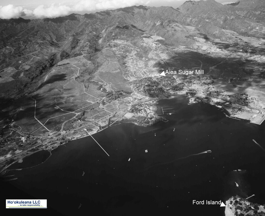
On December 12, 1794, a great battle was fought; Kalanikūpule himself with the main army held the middle ground between ʻAiea and the taro patches; Captain Brown’s men were in boats guarding the shoreline.

Thus surrounded, Kāʻeo with six of his men escaped into a ravine below ʻAiea and might have disappeared there had not the red of his feather cloak been seen from the boats at sea and their shots drawn the attention of those on land. Hemmed in from above, Kāʻeo was killed.  (Kamakau)

Toward the end of December a plot was formed among the natives for the seizure of the two vessels (Jackal and Prince Lee Boo.) On the first day of January, 1795, the plan was put in place.

The Englishmen being thus scattered and the vessels almost deserted, except for the two captains, who remained on board.

“Capt. Brown was walking the poop, by himself, when one of ye Savages gets up on the poop, & made a pass at the Good old Captain with an Iron dagger, which he fend’d of, & seizd a Swivell worm & drove the fellow of, he was soon followed by a number more which the captain likewise beat of …”

“… but at last he was overpower’d by numbers, & receiv’d a fatal stab in the back of the neck and was pitch’d from the poop on to the main deck where he soon expir’d, & so by there savage artfulness they got possession of both Vessells without the loss of a man on there side, in the mean time they had seiz’d the Boats & People that where on shore”.  (Boit; Kuykendall)

Being in possession of the two ships, with a large quantity of arms and ammunition, Kalanikūpule and his advisers conceived this to be an opportune moment for striking a decisive blow at Kamehameha.

The surviving members of the crews were compelled, under guard, to fit the vessels for sea, and when all was ready the king and his chiefs went on board and the ships were warped out of Fairhaven harbor and anchored in Waikiki bay.

The next day Mr. Bonallack, mate of the Prince Lee Boo, and Mr. Lamport, mate of the Jackal, agreed upon a plan for retaking the vessels that night. It was a desperate venture but the attempt was entirely successful, the natives on board being killed or driven off, with the exception of the king, queen, and three or four of their personal attendants.

The ships immediately put to sea, but at daybreak they again came near the shore and, after placing the king and queen in a canoe with one attendant, made all sail for the island of Hawaii, and from there, after procuring supplies, took their departure for Canton.

In 1795 Kamehameha sailed from his home island of Hawaiʻi with an army of thousands of warriors, including a handful of non-Hawaiian foreigners to battle Kalanikūpule.

The war apparently ends with some of Kalanikūpule’s warriors pushed/jumping off the Pali.  When the Pali Highway was being built, excavators counted approximately 800-skulls, believed to be the remains of the warriors who were defeated by Kamehameha.

Within less than five months after the death of Captain Brown, Kamehameha over-ran Maui and Molokai, defeated Kalanikūpule in the great battle of Nuʻuanu, and became ruler of all the islands except Kauai. (Kuykendall)

Kamehameha launched his first invasion attempt on Kauai in April of 1796, having already conquered the other Hawaiian Islands, and having fought his last major battle at Nuʻuanu on O‘ahu in 1795.

Kauai’s opposing factions (Kaumuali‘i versus Keawe) were extremely vulnerable as they had been weakened by fighting each other (Keawe died and Kaumuali‘i was, ultimately, ruler of Kauai and Ni‘ihau.)  Kamehameha’s two attempts at invading Kauai were foiled (by storm and sickness.)  The island was never conquered.

Then, on March 3, 1810, Kamehameha wrote his letter to King George – this summary explains how/why he moved to O‘ahu.

Then, in April of 1810, at Pākākā, Kamehameha’s compound at Honolulu Harbor, negotiations between King Kaumuali‘i and Kamehameha I took place; facing the threat of a further invasion, Kaumualiʻi yielded to Kamehameha.  The agreement marked the end of war and thoughts of war across the islands.

© 2023 Ho‘okuleana LLC

Filed Under: Hawaiian Traditions, Prominent People, Sailing, Shipping & Shipwrecks, General, Ali'i / Chiefs / Governance Tagged With: Kamehameha, Kaeo, Kalanikupule, Butterworth, Prince Lee Boo, Jackal, King George III, Captain William Brown

December 12, 2022 by Peter T Young Leave a Comment

Kalauao

At the time of Cook’s arrival (1778,) the Hawaiian Islands were divided into four kingdoms: (1) the island of Hawaiʻi under the rule of Kalaniʻōpuʻu, who also had possession of the Hāna district of east Maui; (2) Maui (except the Hāna district,) Molokaʻi, Lānaʻi and Kahoʻolawe, ruled by Kahekili; (3) Oʻahu, under the rule of Kahahana; and at (4) Kauaʻi and Niʻihau, Kamakahelei was ruler.

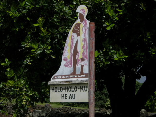
“At that time Kahekili was plotting for the downfall of Kahahana and the seizure of Oahu and Molokai, and the queen of Kauai was disposed to assist him in these enterprises.”  (Kalākaua)  Kamakahelei was married to Kāʻeokūlani (Kāʻeo – younger brother of Kahekili.)  Kamakahelei and Kāʻeo had a son Kaumualiʻi (born in 1778 at Holoholokū.)

Kahekili and his eldest son and heir-apparent, Kalanikūpule, conquered Kahahana, adding Oʻahu under his control.  And, in the late-1780s into 1790, Kamehameha conquered the Island of Hawai‘i and was pursuing conquest of Maui and eventually sought to conquer the rest of the archipelago.

The rich resources of the region, the shoreline fishponds, the numerous springs, and the fertile lands along the streams made ‘Ewa a prize for competing chiefs. Battles were fought for and on ‘Ewa lands, sometimes from competing O‘ahu chiefs, and sometimes by invading chiefs from other islands.  (Cultural Surveys)

At the death of Kahekili in 1793, Kāʻeo became ruling chief of Maui, Molokaʻi and Lānaʻi.  Kalanikūpule was ruler of Oʻahu.  Homesick for his friends, Kāʻeo set out to return to Kauaʻi by way of Waialua and then to Waimea.  He learned of a conspiracy to kill him and by November, 1794, Kāʻeo and Kalanikūpule were ready to fight.  (Kamakau)

Kāʻeo was successful after some initial skirmishes.  On December 12, 1794, a great battle was fought in the area between Kalauao and ‘Aiea in ‘Ewa.  Kalanikūpule’s forces surrounded Kāʻeo.  (Cultural Surveys)

Kāʻeo with six of his men escaped into a ravine below ‘Aiea and might have disappeared there had not the red of his feather cloak been seen from the boats at sea and there shots drawn the attention of those on land. Hemmed in from above, he was killed fighting bravely.  (Kamakau)

This war, called Kukiʻiahu, was fought from November 16 to December 12, 1794 at Kalauao in ‘Ewa.  (Kamakau)  (It wasn’t long after that Kalanikūpule battled Kamehameha, again; and lost to Kamehameha at the Battle of Nuʻuanu.)

Kalauao Ahupua‘a (the multitude of clouds) extends from the East Loch of Pearl Harbor to the crest of the Koʻolau Range, generally following Kalauao Stream. Kalauao Spring is located near the Pearl Harbor coast.

The Kalauao Spring included two natural springs of percolating water.  In ancient times, the springs irrigated taro loʻi.  Later, the ancient taro lo‘i and ʻauwai (irrigation ditches) were modified and expanded to support rice cultivation.

In 1904, the area was described as, “On the morning of June 2nd, for instance, our destination was Aiea. At ten minutes past seven we boarded the first passenger train going towards Honolulu.”

“For a distance of eight miles the road skirts the shore and then turns landwards or mauka through rice and sugar plantations, Ewa Mill, Waipahu, Pearl City. …”

“Like all rice fields in Hawaii, this one is worked entirely by Chinamen, they alone being able to endure the conditions of location and climate necessary for the cultivation of this cereal.”

“On one side of the railroad track was the broad, muddy inland lake or bay of salt water, Pearl Harbor; on the other side were the terraced plots or fields, flooded to a depth of several inches with water and separated by narrow raised earthen ridges on which the careful Chinaman doubtless succeeded in walking, but which many times proved treacherous to our unsteady feet.”

“A rice plantation, laid out as it generally is on the low flats at the foot of a valley, where mountain streams empty into the sea, is an ideal collecting ground for certain kinds of algae.”  (Thrum 1904)

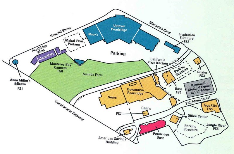
In 1928, Moriichi and Makiyo Sumida began farming assorted wetland produce on a two-acre plot of land at the springs.  Back then, the area of the springs contained many small farms growing similar produce — bananas, taro, rice, and watercress. Through the ensuing years, the Sumida property grew as they acquired neighboring leases and, by 1950, watercress became the sole crop.  (NPS)

A small waterfall along Kalauao Stream, named Kahuawai (or Kahuewai), was located along the coastal trail connecting Honolulu to Waiʻanae.  Kahuawai (water gourd container) was indicated to have been “a favorite resting place exclusively for chiefs”.  (Cultural Surveys)

Kahuawai was a noted bathing place since ancient times and was guarded so that any one did not bathe in it except the chiefs. Later it was used by all. Kākuhihewa’s daughters and the hero Kalelealuaka (their husband) bathed in this pool. Kāʻeokūlani, the chief of Kauaʻi also bathed here when he came to war here on Oʻahu.  (Cultural Surveys)

Loko Opu, a large fishpond (approximately 10.5-acres in size) located in Kalauao along the Pearl Harbor coast, is said to have been built by the chiefess Kalamanuʻia.  (Cultural Surveys)

During the Māhele, much of the lands in the ahupua‘a of ‘Ewa, as in other districts, were awarded to Ali‘i Nui (high chiefs), who were either the grandchildren or great-grandchildren of Kamehameha I.

Half of the ahupua‘a of Kalauao was awarded to Laura Konia (either granddaughter or grandniece of Kamehameha I;) the other half of Kalauao Ahupua‘a was awarded to John Meek, an important merchant in the sandalwood trade.

Today, the Pearl Country Club covers much of the lower section of Kalauao.   Pearlridge Shopping Center is on the lowest side of Kalauao (Pearlridge Uptown was opened in 1972, with an expansion in 1976 to include Pearlridge Downtown.)  Pearlridge surrounds the evidence of the water resources of old, Kalauao Spring that benefits the Sumida watercress farm.

© 2022 Hoʻokuleana LLC

Filed Under: Place Names Tagged With: Pearlridge, Hawaii, Oahu, Kalanikupule, Ahupuaa, Kaeo, Ewa, Sumida Watercress, Kalauao

July 9, 2022 by Peter T Young Leave a Comment

Keawalaʻi Congregational Church

Keawakapu is the traditional name of the bay fronting Ka‘eo, and is the ‘ili where the historical church (now known as Keawala‘i), is situated. In the present day, the place names, Ka‘eo and Keawakapu are not widely used.

The name Keawakapu is almost unknown in this area. This is because the name “Keawala‘i” for the Hawaiian Church has been generally in use since sometime in the early-1900s.   Keawakapu was the traditional name of the ‘ili on which the Church is situated. (Maly)

The traditional name of a neighboring bay, Makena actually in the ahupua‘a of Papa‘anui, is the locality name most familiar. The association of the larger area with the name Makena – formerly only a small locality name in a larger ahupua‘a of the Honua‘ula District – dates back to the late-1840s, when the bay of Makena was made the primary landing and coastal economic center of the region.

From 1800 to the 1840s (in the period prior to the Mähele ‘Äina), the land of Ka‘eo was managed for members of the Kamehameha household and supporting high chiefs by  konohiki—lesser chiefs appointed by Kamehameha III and Ulumäheihei Hoapili. (Maly)

Up to the early 1840s, land use, access, and subsistence activities in Ka‘eo remained as it had from ancient times. But by the middle 1840s, land use in Ka‘eo and in neighboring lands, transitioned from traditional subsistence agriculture to business interests, focused on ranching and plantations (the latter occurring in the cooler uplands).

Honua‘ula District was one frequented by droughts and famines. Native residents supported  themselves by cultivating in the uplands, and fishing, with some lowlands agriculture when rains fell. They also traded woven goods and other items for  kalo from Na Wai ‘Ehä (Waikapü, Wailuku, Wai‘ehu and Waihe‘e.)  (Maly)

Also, in the 1830s, just prior to the development of fee-simple property rights in the Hawaiian Kingdom, the land of Ka‘eo was selected as the center for educational and church work in the Honua‘ula District.

The first place of worship and instruction was established at Keawakapu, Ka‘eo, in 1825, as a thatched pili grass structure.

On August 1st and 8th, 1834, Ka Lama Hawai‘i published two letters from John S. Green (Garina), reporting on a visit to the various church stations of East Maui, including Honua‘ula. Green wrote to Lorin Andrews reporting that there were few children at the Honua‘ula Church (Keawakapu), but that he preached to a gathering of nearly 2,000 people, observing the people of the district were very poor.  (Maly)

In 1856, the Sunday school raised $70 which was sent to the United States to buy a bell for the church. (The bell arrived in January 1860 and was lifted to the belfry in February 1862.)

The Stone Meeting House at Keawakapu (also called Honua‘ula or Makena Church) was completed in 1858.

The land where the church now stands was purchased in 1864.  The minister asked that the property, church and deed be turned over to the mission in Boston, but the members voted to retain the property as their own and elected trustees who had charge of the worship services in the absence of ministers.

Life in Mākena was not easy a hundred years ago and it did not get easier as time went on. First, because the weather pattern for the area changed, the once fertile lands became parched and the small farmers who lived in Mākena were forced to pick up and begin their lives again elsewhere on Maui. Then came the Great Depression, then Second World War.

In 1944, the church known as the Stone House, Honuaʻula, Keawekapu, Makena and Kaʻeo was renamed Keawalaʻi – the name it retains today.

The plight of the church went virtually unnoticed until Kahu Abraham Akaka spearheaded a rededication of the church on May 25, 1952. The church structure was repaired and a new, revitalized spirit came over the small congregation. Membership rose.

When the belfry collapsed in January 1968, the church members decided to build a new one and to do repairs on the interior, including replacement of the windows and doors.

In 1975 the church building was in need of restoration and funds were raised by members and friends and the work undertaken; the old roof was removed and all damaged rafters and trusses were replaced. On May 16, 1976 a worship service was held with the rededication and a lū‘au.

The church has made a commitment to maintain Hawaiian tradition and culture, to incorporate the use of Hawaiian language, music and dance as well as to honor the various traditions and cultures represented in its membership within its ministry of worship and service. Lots of information here is from Kepa Maly and the Keawalaʻi Church website. 

© 2022 Hoʻokuleana LLC

Filed Under: Missionaries / Churches / Religious Buildings Tagged With: Hawaii, Maui, Kaeo, Makena, Keawakapu, Honuaula, Keawalai Church

April 23, 2022 by Peter T Young 2 Comments

Holoholokū

Hānau ke aliʻi I loko o
Holoholokū, he aliʻi nui
Hānau ke kanaka I loko o
Holoholokū, he aliʻi no
Hānau ke aliʻi mawaho aʻe o H
Holoholokū ʻaʻohe aliʻi
he kanaka ia.

The child of a chief born in
Holoholokū is a high chief;
The child of a commoner born
in Holoholokū is a chief;
The child of a chief born outside
of the borders of Holoholokū
is a commoner.

The traditional name was Ka Lae o Ka Manu, which means the crest of the bird. Holoholokū appears to have been the ancient locality name.  (NPS)

Oral traditions tell of the sacred births of Kauaʻinui and Wailuanuihoʻano and the establishment of this area as a birthing site reserved for royalty. It is still considered as one of Hawaiʻi’s most sacred sites.  (Wailua Heritage Trail)

Holoholokū at Wailua on Kaua’i was one of two places in Hawai‘i specifically designated for the birth of high ranking children; the other site was Kūkaniloko near Wahiawa on Oʻahu.

Here all the kings of Kauaʻi were born, from earliest times to King Kaumualiʻi.  Aliʻi from other islands would also come here to give birth.

Kaumuali‘i was the only son of Kamakahelei and Kāʻeo (his mother Kamakahelei ruled the island when Captain James Cook made ‘contact’ in 1778.)  Kaumualiʻi was born the same year at Holoholokū. Kaumuali‘i became ruling chief of Kaua‘i upon the death of his parents.

It is said to be the oldest heiau on Kauaʻi and was named for a foster parent of Kawelo, son of Kauai’s ruling chief Mano-kalani-po and his wife Ka-wai-kini early in the 17th century.

Two boulders are within the heiau; the pōhaku hānau (birthstone) is actually two rocks.  Expectant mothers sat on the flat rock and rested her back on the other; when in use, the rocks were enclosed in a shelter and the rocks were covered with mats and kapa.

“… when an expectant mother of royal lineage was about to deliver her child, she would travel to the birthstone and squat on the ledge, leaning back against the upright section of the stone. After the birth, the mother and child were moved into a cave adjacent to the stone …“

“The mother remained in the cave with her child and retinue until she was able to travel; a booth or temporary shelter was built over the place. This was the sacred birthplace of the aliʻi or chiefs.”

“If the child really were a great chief, the heavens allegedly would burst forth with thunder and lightning, and there would be a heavy downpour of rain. A rainbow would arch over the area, with one end indicating the spot where the child had been born.”  (NPS)

A tradition describes how the piko (navel cord) of a newborn child was placed in the nearby Pōhaku Piko; if a rat stole the piko it was an omen that the child would grow up to be a thief, and allegedly the child was put to death. (NPS)

Another legend states that the newborn child was carried up a path to a boulder on the ridge, overlooking the river.  As the kahuna walked, he chanted of the arrival of the new chief.  (Joesting)

Within the walls of the heiau was a grass-thatched house of the kahuna.  “Bits of branch coral (indicative of sacredness) are scattered through the walls. Small, water-worn pebbles out on the earthen floor indicate the former presence of a house floor-pavement.”

“The west side of the heiau is bounded by a terrace and at the south end of this terrace, the south-west corner of the heiau, is a great horizontal ledge of stone, called the sacrificial stone.”

“Built out from the north side of this ledge is a little terrace, 9 feet square ….. I am certain the heiau of Ka-lae-o-ka-manu, or Holoholokū served in conjunction with the birth place, and that here the drum which would announce the news would be kept, as the drum of Kūkaniloko was kept in the near-by heiau.”  (Emery, 1933)

In December 1933, restoration of the Holoholokū heiau was completed by a team of volunteers led by Grove Farm director Henry Digby Sloggett, with Kapaʻa resident Charles Lono Kelekoma and Honolulu’s Bishop Museum providing technical expertise.   (TGI)

© 2022 Hoʻokuleana LLC

Filed Under: Ali'i / Chiefs / Governance, Hawaiian Traditions, Place Names Tagged With: Kaumualii, Hawaii, Holoholoku, Kukaniloko, Kauai, Kamakahelei, Kaeo, Wailua

  • 1
  • 2
  • Next Page »

Images of Old Hawaiʻi

People, places, and events in Hawaiʻi’s past come alive through text and media in “Images of Old Hawaiʻi.” These posts are informal historic summaries presented for personal, non-commercial, and educational purposes.

Info@Hookuleana.com

Connect with Us

  • Email
  • Facebook
  • LinkedIn
  • Twitter
  • YouTube

Recent Posts

  • About 250 Years Ago … Battles of Saratoga
  • Spanish Lake
  • New Wives, New Mothers
  • Water Crisis
  • Waiʻanapanapa
  • 250 Years Ago – George Washington Address to the Inhabitants of Canada
  • Elmer Ellsworth Conant

Categories

  • Voyage of the Thaddeus
  • Mayflower Summaries
  • American Revolution
  • General
  • Ali'i / Chiefs / Governance
  • Buildings
  • Missionaries / Churches / Religious Buildings
  • Hawaiian Traditions
  • Military
  • Place Names
  • Prominent People
  • Schools
  • Sailing, Shipping & Shipwrecks
  • Economy

Tags

Albatross Al Capone Ane Keohokalole Archibald Campbell Bernice Pauahi Bishop Charles Reed Bishop Downtown Honolulu Eruption Founder's Day George Patton Great Wall of Kuakini Green Sea Turtle Hawaii Hawaii Island Hermes Hilo Holoikauaua Honolulu Isaac Davis James Robinson Kamae Kamaeokalani Kamanawa Kameeiamoku Kamehameha Schools Lalani Village Lava Flow Lelia Byrd Liliuokalani Mao Math Mauna Loa Midway Monk Seal Northwestern Hawaiian Islands Oahu Papahanaumokuakea Marine National Monument Pearl Pualani Mossman Queen Liliuokalani Thomas Jaggar Volcano Waikiki Wake Wisdom

Hoʻokuleana LLC

Hoʻokuleana LLC is a Planning and Consulting firm assisting property owners with Land Use Planning efforts, including Environmental Review, Entitlement Process, Permitting, Community Outreach, etc. We are uniquely positioned to assist you in a variety of needs.

Info@Hookuleana.com

Copyright © 2012-2024 Peter T Young, Hoʻokuleana LLC


Loading Comments...