Images of Old Hawaiʻi

  • Home
  • About
  • Categories
    • Ali’i / Chiefs / Governance
    • American Protestant Mission
    • Buildings
    • Collections
    • Economy
    • Missionaries / Churches / Religious Buildings
    • General
    • Hawaiian Traditions
    • Other Summaries
    • Mayflower Summaries
    • Mayflower Full Summaries
    • Military
    • Place Names
    • Prominent People
    • Schools
    • Sailing, Shipping & Shipwrecks
    • Voyage of the Thaddeus
  • Collections
  • Contact
  • Follow

October 15, 2024 by Peter T Young Leave a Comment

Papaʻāpoho

Papaʻāpoho describes a flat area with a depression or hollow, which is how the island of Papaʻāpoho is shaped.  It’s over 1,000-miles from Honolulu.

This 23.4-million-year-old island is over 1.2-miles across and has a land area of approximately 400-acres, making it the third largest island within the Papahānaumokuākea Marine National Monument (to the northwest of the Main Hawaiian Islands.)

Like its name, the island has an elevated rim (its highest point is a 40-foot-high sand dune) surrounding a broad central depression; its lowest point is a depression to the south that runs as a channel toward the ocean.

“This is a low, sandy island, elevated from 20 to 40 feet above the sea. It is about 1 1/4 miles long, and the northern part one mile wide; the surface is covered with green coarse grass.”

“There is what has been a lagoon near the southern part of the island, in the centre of which fresh water was found by digging 5-feet. Birds, fish, seal and turtle abound here, but not so plentiful as at Laysan Island.”  (Paty, Polynesian, June 6, 1857)

At 10 pm, October 15, 1805, Urey Lisiansky (Yuri Fyodorovich Lisyansky,) an officer in the Imperial Russian Navy and commanding officer of the exploratory sloop-of-war Neva, ran aground on the island.  Captain Lisiansky jettisoned some of the ship’s cargo to free themselves from the shallow waters.

“This island promises nothing to the adventurous voyager but certain danger in the first instance, and almost unavoidable destruction in the event. It stands in the middle of a very perilous coral bank, and, exclusive of a small eminence on the eastern part, lies almost on a level with the sea.”  (A Voyage Round the World, Lisiansky, 1805)

 “As there is no water, so neither are any trees to be seen on this island. We found, however, several large trunks of trees on the beach, which, no doubt, had been thrown up by the sea. … They were like the red-wood tree, that grows on the banks of the river Columbia in America. I am at a loss what conclusion to draw from the appearance of these trunks of trees in so remote a place.”  (A Voyage Round the World, Lisiansky, 1805)

“I also found on the beach a small callabash, which had a round hole cut on one side of it. This could not have been drifted from a great distance, as it was fresh and in good preservation.”  (A Voyage Round the World, Lisiansky, 1805)

Before leaving, Lisiansky named the island and shoal; “To the south-east point of the bank where the vessel grounded, I gave the name of Neva; while the island itself, in compliance with the unanimous wishes of my ship’s company, received the appellation of Lisiansky.”  (A Voyage Round the World, Lisiansky, 1805)

The spelling Lisianski (not Lisyansky) was officially adopted by the US Geographic Board, October 1, 1924. Other names by which the island has been called include: Lisiansky, Lysianski, Lassion and Pell.  (Thrum)

In 1857, King Kamehameha IV asked Captain John Paty to make a voyage of exploration to the Northwestern Hawaiian Islands.  In part, he was sent to investigate the possibility of guano deposits on islands there (for fertilizer for the growing agricultural economy back on the Main Hawaiian Islands.

In addition, he confirmed or corrected the existence (or not) of many islands noted on old charts; “A considerable portion of the time absent has been consumed in looking after islands and banks which do not exist, or are erroneously marked on Blunt’s charts.”  (Paty, Polynesian, June 6, 1857)

In the course of his voyage on the schooner “Manuokawai,” on May 11, 1857, Paty took possession of Lisianski Island for the Hawaiian Kingdom (he had previously annexed Laysan, its nearest neighbor, on May 1, 1857.)

In 1890, George D Freeth, an Englishman who had visited the area as early as 1864, and George N Wilcox, who had previously managed a guano operation on Jarvis Island, formed the North Pacific Phosphate and Fertilizer Company.

March 31, 1893, the Provisional Government of the Hawaiian Islands adopted Act 22, confirming the contract between the Minister of Interior and North Pacific for a license for the removal of guano and phosphates from Lisianski (and Laysan.)

Guano mining (1890s,) the release of rabbits (1903) and mice caused ecological damage to Lisianski, as well as the loss of a breeding population of land birds (the Laysan duck was first reported on Lisianski Island in 1828.)

Feather collecting began on Lisianski about 1904. In response to public outcry about the feather trade, Theodore Roosevelt established the Hawaiian Island Bird Reservation, which included Lisianski, in 1909.

An armed party landed on the island in 1910. They arrested feather poachers and confiscated and destroyed about 1.4 tons of feathers, representing 140,400 birds.  (NOAA)

Today, with poaching at an end, the rabbits exterminated, and the vegetation again spreading over its low sandy surface, Lisianski once more is becoming a populous bird sanctuary.  (janeresture)

It is home to a large Bonin petrel colony (over three-quarters of the Bonin Petrels that nest in Hawaii nest here) and sooty tern colony, as well as a variety of other seabirds.

Lisianski has the only grove of Pisonia grandis trees in the entire Hawaiian Archipelago; this tree is dispersed by seabirds and is favored as a nesting site for many tree-nesting seabird species.

The reefs of Lisianski and surrounding Neva Shoals are called “coral gardens” by some scientists because of their abundance of coral and the variety of growth forms assumed by their colonies, including structures resembling spires, castles, and a variety of other shapes.

Hawaiian monk seals and green sea turtles are common visitors to Lisianski’s sandy white beaches. Migratory shorebirds seen on the island include the kolea (golden plover,) ulili (wandering tattler,) and kioea (bristle-thighed curlew.) The volcanic island is undergoing the slow process of erosion.  (NOAA)

Click HERE for a link to a ‘street view’ of Lisianski.

© 2024 Hoʻokuleana LLC


Filed Under: Place Names, Sailing, Shipping & Shipwrecks Tagged With: John Paty, Papaapoho, Lisianski, Hawaii, Papahanaumokuakea Marine National Monument, Kamehameha V, NWHI, Yuri Fyodorovich Lisyansky, GN Wilcox

October 14, 2024 by Peter T Young Leave a Comment

Boiling Pots

There are two rivers in the Hawaiian Islands bearing the name of Wailuku. One is on the Island of Maui, flowing out of a deep gorge in the side of the extinct volcano ‘Īao. The other Wailuku River is on the Island of Hawaii.

The Wailuku is the longest river in Hilo (twenty-six miles.) Its course runs from the mountains to the ocean. The Wailuku is the boundary between Hilo Palikū in the north and Hilo One on the south.

Hawaiians were impressed by this Wailuku and wove a dramatic tale around several interesting geologic features within the river.

Hina, the moon goddess and mother of Maui, lived in the cave beneath Rainbow Falls, concealed by the mist of the falls. Each day she beat and dried her kapa in the sun.

Far above the cave, in the bed of the river, dwelt Kuna. [Kuna is a variety of freshwater eel [or Mo‘o (dragon)] said to have been introduced from abroad. (Parker)]  That portion of the river runs bears to this day the name ‘Waikuna’ or ‘Kuna’s river.’

Kuna often tormented Hina by sending over great torrents of water or by rolling logs and boulders down the stream. This would block the stream below the falls to dam the river and drown Hina.

Hina was frequently left with but little protection, and yet from her home in the cave feared nothing that Kuna could do. Precipices guarded the cave on either side, and any approach of an enemy through the falling water could be easily thwarted.

During a particularly intense storm, Mo‘o Kuna moved a huge boulder over the falls and into the river, where it fit perfectly and prevented water from flowing farther. Water level beneath the falls began to rise.

Hina, realizing her danger, signaled her son. With two powerful strokes, he paddled his canoe from Maui to the mouth of the Wailuku. He rushed upstream and split the damming boulder with a single blow, thereby saving his mother.

By this time, Kuna had fled upstream. Maui found Kuna hiding in a hole beneath the river. He tried to spear Kuna, but Kuna escaped. Finally, Kuna found deep hiding holes and thought to be safe.

Maui again found Kuna and called upon Pele to send lava into the river to drive out Kuna.  The red-hot burning stones in the water made the pools boiling and the steam was rising in clouds – Kuna uttered incantation after incantation, but the water scalded and burned Kuna.

Kuna leaped from the pools and fled down the river. The waters of the pools are no longer scalding, but they have never lost the tumbling, tossing, foaming, boiling swirl which Maui gave to them when he threw into them the red-hot stones with which he hoped to destroy Kuna, and they are known today as the ‘Boiling Pots.’  (Westervelt, USGS)

Despite the name, the water is not normally hot. The only time in the modern history of the river that the water was heated was in 1855 and 1856 when a lava flow from Mauna Loa advanced across the Saddle between that volcano and Mauna Kea. Lava flowed into the Wailuku River channel, but did not cross it, about 4 miles above the Boiling Pots. (BIVN)

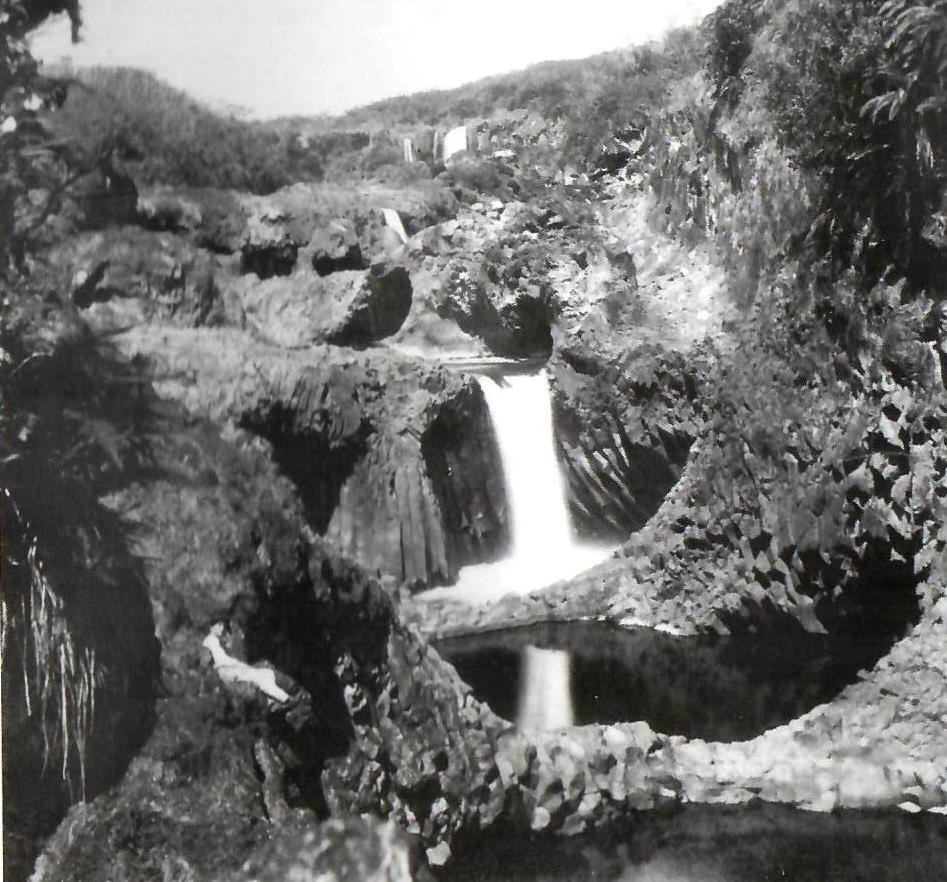
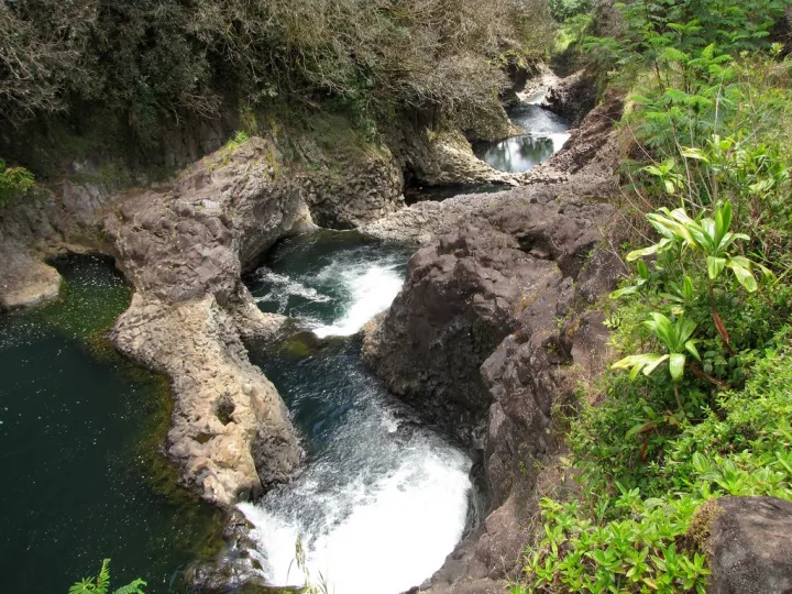
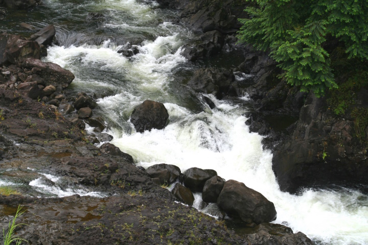
The Boiling Pots is about 1.5 miles upstream from Rainbow Falls and is a succession of eroded, hollowed out terraced pools that fill with the flow of the river. When the river is engorged with storm runoff, the ‘pots’ fill to the brim, become turbulent and appear to ‘boil.’  (HawaiianAir)

The Wailuku River is an important landmark to geologists, because it marks the approximate boundary between the lava flows of Mauna Kea and Mauna Loa. It is the state’s longest river and the southernmost that carries water all year.

According to the USGS, the river was formed by at least two lava flows coming from Mauna Kea, the oldest, the ‘Anuenue flow (as old as 10,500 years), is the same flow that formed the thick lip of Rainbow Falls and most of the rounded, gray boulders at Boiling Pots.

Tracing the flows up and down the Wailuku tells a geologic story of a river that had already deeply cut into Mauna Kea and Mauna Loa flows when it was filled by the ‘Anuenue flow over 10,000 years ago. Many of these boulders are frozen into a younger pahoehoe flow, named after the Punahoa ahupua‘a and about 3,100 years old.

The filling caused the river to shift in many places and resume its erosional downcutting before lava again ventured into the river 3,100 years ago. (The Hawaiian and the geologic versions of the Wailuku River story have many similarities, including the pools – ‘pots.’ (USGS)

The pots, each about 50-feet in diameter, are eroded into the 10,500 year old Mauna Loa lava flow. When the water is low, the river does not flow over some of the pot rims but it continues to flow through them. (USGS)

An average of 275-million gallons of water flows through the Wailuku to Hilo daily – during intense storms, the discharge can be more than 20 times greater. On average, the Wailuku transports approximately 10 tons of suspended sediment into Hilo Bay each day.

About a half mile up the river from the boiling pots is Peʻepeʻe Falls.  Waiānuenue Avenue (rainbow (seen in) water) is named for the most famous waterfall, Ka Wailele ʻO Waiānuenue, Rainbow Falls on the Wailuku River.

DLNR operated the Wailuku River State Park, here. There are two separate park areas, Boiling Pots and Rainbow Falls. Flash flooding is common, and because there are no lifeguards, many have perished in the river by getting sucked into the water and becoming trapped within concealed lava tubes and caves.

The best way to experience this beautiful and deadly natural phenomena is from a cement overlook, just a short walk from the paved parking lot.

© 2024 Ho‘okuleana LLC

Filed Under: General, Place Names Tagged With: Hawaii, Hilo, Wailuku River, Boiling Pots

October 12, 2024 by Peter T Young Leave a Comment

Moa

The first birds to be introduced into the Islands came with early Polynesians, who brought the Moa – Red Junglefowl (Gallus gallus) – for food.

“It is not clearly understood how this species interacted with the terrestrial native birds, how it competed for resources, and what diseases might have been introduced with it, but the introduction of this bird by the Polynesians as a domestic animal probably had some impact.”

“[T]he Red Junglefowl is found in numbers only on Kauai, which lacks the mongoose, but it was formerly established in the wild on all the main islands. Its reproductive potential is high, and it is omnivorous.”

“It seems very likely to us that this species in large numbers could have been a potent competitor to some species of ground-foraging native birds, such as the smaller rails, only one of which survived into historical times.” (Van Riper and Scott)

This “original chicken” is smaller than its domestic descendants and is widespread throughout South and Southeast Asia; can also be found as an introduced species in many regions around the world (especially prevalent on many Pacific Islands, including Hawaii). (eBird)

“Dr. Stanley C. Ball … has studied the Polynesian chickens (moa) and concluded that they were brought from Malaysia to Polynesia, where they were found in all the islands except New Zealand.”

“‘The wooden breast-plates carved by the natives of Rapanui (Easter Island) to represent the cock, and the few traditions which mention this bird, lend weight to the view that the fowl has long been associated with the inhabitants of even the easternmost islands of Polynesia.’”

“‘The Malaysian region, from which fowls were evidently brought to the Pacific islands, was very close to, if not actually the home of, the wild jungle fowl (Gallus gallus),’ Dr. Ball states.”

“It is found from the southern Himalayas, through India, Java, Timor, Lombok, the Philippines, Balabac, Palawan, and Hainan, into Micronesia, Melanesia, and Polynesia.”

“Ball believed (and rightly, without doubt) that the chickens brought by Polynesian migrants were already domesticated, and that wild chickens to be found in the Marquesas, Tahiti, Hawaii, and elsewhere have reverted to the wild.” (Handy, Handy & Pukui)

As noted in Captain Cook’s journal, “The hogs, dogs, and fowls, which were the only tame or domestic animals that we found here, were all of the same kind that we met with at the South Pacific islands. There were also small lizards; and some rats, resembling those seen at every island at which we had as yet touched.”

“Of animal food, they can be in no want; as they have abundance of hogs, which run, without restraint, about the houses; and if they eat dogs, which is not improbable, their stock of these seem to be very considerable … They eat fowls of the same domestic kind as ours, but they are neither plentiful nor much esteemed by them.” (Cook’s Journal)

“Probably Hawaiians regarded their chickens as second-rate fare because chicken meat steamed in an imu is less flavorful for eating with poi than is good fish.”

“We may be sure, nevertheless, that the pioneering voyagers to these islands would not have taken the trouble to keep alive hens and roosters on their long voyages hither if they had not prized them.”

“Mrs. Pukui remembers, however, that even in her childhood older Hawaiians would not eat eggs. ‘It would be like eating the hen’s unborn baby,’ her grandmother said with distaste.” (Handy, Handy & Pukui)

“Mrs. Pukui has, with the help of her mother, Mrs. Pa‘ahana Wiggin, recorded the following colors and names of a variety of native chickens in old Hawaii.”

“The moa of Hawai‘i were smaller than the haole (introduced) chicken, legs shorter, and bodies longer. A pure white moa was called moa-ke‘oke‘o,  -Iawa, or -wakea. A black moa was called a hiwa or hiwa-pa‘a.”

“The moa nene were speckled like the Hawaiian goose (nene) . Those with yellowish-cream feathers were called pua-hau, for the yellow hau flower. Smoky gray ones were called lehu or nalehu. (ashy). Speckled with feathers of variegated colors were the ‘opule-pule (mixed-up-crazily).”

“With a ring of feathers around the neck like the plover, it was the moa ‘a‘i kolea. The ‘ulahiwa ranged in shade from a light red to a deep ocherous red. White with red feathers on the back was termed lawa a‘ea‘e (mixed).”

“(The Pukui-Elbert dictionary, 1957, adds two others: the completely black chicken, similar to the mud hen ‘alae, is called moa ‘alae; the black chicken with red feathers at neck and rump is moa ‘alae hulu ‘ula.)”

“The long, curving, irridescent tail feathers of the cocks are always present. These were prized in the Marquesas for warriors’ headdresses, and in Hawaii for making the tall feather-trimmed standards (kahili) that were emblems of rank.” (Handy, Handy & Pukui)

“We have often heard the shrill crow of wild roosters in the forests around Koke‘e, above Waimea Canyon on the island of Kauai. These cocks are bright-hued. They have crossbred with Indonesian jungle fowl imported some years ago.”

“In the Marquesas the hours before dawn were named ‘first-cock’s-crow,’ ‘second-cock’s-crow,’ and ‘third-cock’s-crow’; in Hawaii likewise: ‘moa-kua-kahi,’ ‘moa-kua-lua,’ ‘moa-kua-kolu.’”

“In Hawaii, if a cock crew much too early it was a sign that canoes might be expected to make an appearance. If a cock came right to the house door to crow, it announced the imminent arrival of visitors and warned the family to make preparations.”

“The Hawaiian fowl is traditionally identified with the Lono-Pele migration, specifically with ‘Olopana, paramount chief of Ko‘olau on Oahu. The first predacious exploit of the doughty Kamapua‘a (‘Hog-child,’ a demigod) was killing jungle fowl belonging to his uncle ‘Olopana.”

“And it was Ka-wa‘u-hele-moa (The-fowl-scratching-as-it-goes), a native sprite in the form of a fowl, who saw the thievery and gave the alarm to ‘Olopana, thus precipitating notable warfare. Ka-wa‘u-hele-moa lived in Palolo Valley, above the southerly shore of Oahu, and plays an active role in several legends.” (Handy, Handy & Pukui)

“Cock-fighting (haka-moa) was a very fashionable sport with the aliis”. (Malo) Chickens were thought to be forms of the mo‘o (reptile) class of ancestral gods (‘aumakua).

“Their greatest importance to Hawaiians was their use as offerings to temple gods and to family gods. Often a chicken of a particular color was called for as an offering in a healing rite. Sacrificed chickens played an important part in any ritual performed to fend off black magic.” (Handy, Handy & Pukui)

© 2024 Ho‘okuleana LLC

Filed Under: General, Hawaiian Traditions, Economy Tagged With: Moa, Chicken, Red Junglefowl, Hawaii

October 11, 2024 by Peter T Young Leave a Comment

Hawai‘i Transportation Evolution

The canoe was a principal means of travel in ancient Hawaiʻi, extensive cross-country trail networks.   Overland travel was on foot and followed the traditional trails.

Then, in 1803, American ship under Captain William Shaler (with commercial officer Richard Cleveland,) arrived with three horses aboard – gifts for King Kamehameha.

In the 1820s and 1830s, more horses were imported from California, and by the 1840s the use of introduced horses, mules and bullocks for transportation was increasing.

In 1825, Andrew Bloxam (naturalist aboard the HMS Blonde) noted in Honolulu that, “The streets are formed without order or regularity.  Some of the huts are surrounded by low fences or wooden stakes … As fires often happen the houses are all built apart from each other.  The streets or lanes are far from being clean …” (Clark, HJH)

By the 1830s, King Kamehameha III initiated a program of island-wide improvements on the ala loa, and in 1847, a formal program for development of the alanui aupuni (government roads) was initiated.

Sidewalks were constructed, usually of wood, as early as 1838.  The first sidewalk made of brick was laid down in 1857 by watchmaker Samuel Tawson in front of his shop on Merchant Street.

It wasn’t until 1850 that streets received official names.  On August 30, 1850, the Privy Council first named Hawaiʻi’s streets; there were 35-streets that received official names that day (29 were in Downtown Honolulu, the others nearby).

At the time, “Broadway” was the main street (we now call it King Street;) it was the widest and longest – about 2-3 miles long from the river (Nuʻuanu River on the west) out to the “plains” (to Mānoa).

It wasn’t until 1852 that the Chinese became the first contract laborers to arrive in the islands.  At about that time, Honolulu had approximately 10,000-residents.  Foreigners made up about 6% of that (excluding visiting sailors).  Laws at the time allowed naturalization of foreigners to become subjects of the King (by about that time, about 440 foreigners exercised that right).

The majority of houses were made of grass (hale pili,) there were about 875 of them; there were also 345 adobe houses, 49 stone houses, 49 wooden houses and 29 combination (adobe below, wood above).  In 1847, Washington Place was built by future-Queen Liliʻuokalani’s father-in-law.

The earliest public transit was the Pioneer Omnibus Line, with a horse-pulled vehicle serving parts of Honolulu for a few years beginning in the spring of 1868.  (Schmitt)

In the quarter century from 1872 to 1896 the population just about doubled in the kingdom from 57,000 to 109,000; Honolulu doubled from 15,000 to 30,000.

In 1884, the legislature passed a law “granting to William R. Austin and his associates the right to construct and operate a street railroad upon certain streets of the city of Honolulu.” Later amended, the law granted authority the Hawaiian Tramways Company, Limited (from England.)  (Kuykendall)

In 1888, the animal-powered tramcar service of Hawaiian Tramways ran track from downtown to Waikīkī. In 1900, the Tramway was taken over by the Honolulu Rapid Transit & Land Co (HRT).

That year, an electric trolley (tram line) was put into operation in Honolulu, and then in 1902, a tram line was built to connect Waikīkī and downtown Honolulu. The electric trolley replaced the horse/mule-driven tram cars.

The first automobiles appeared on the streets of Honolulu on October 8, 1899, the date on which both Henry P Baldwin and Edward D Tenney took possession of their newly arrived vehicles (both described as Wood electrics.)  (Schmitt) 

By 1900, Honolulu had a population of more than 39,000 and was in the midst of a development boom, creating tremendous need for more housing.

“[T]here were only four automobiles on Oahu in 1901 – you lived downtown because you worked downtown, you couldn’t live in Kaimuki or in Manoa.”  (Star Bulletin)

The “first gas-engined automobile complete with steering wheel and tonneau,” acquired by CM Cooke in 1904, and the Honolulu Automobile Club later adopted this date for the “first real automobile” in the Islands.  (Schmitt)

Spurring a boom, in 1903, Henry Ford officially opened the Ford Motor Company and five years later released the first Model T.  In 1907, Henry Ford announced his goal for the Ford Motor Company: to create “a motor car for the great multitude.”  (pbs)

“The automobile owner uses his car six days a week either in direct pursuit of his business or as a means of quickly transporting himself and others to and from that place of business.”

“The fact that he may take his family out on a Sunday is not a pleasure trip, but a necessary recreation in order, to ‘keep fit’ for his work.”  (McAlpine, Schuman Carriage, Honolulu Star Bulletin, November 3, 1907)

“The census of 1908 gave 259 cars imported into the islands in that year, thus showing that the automobile is in use pretty generally, as it is now estimated that there are nearly seven hundred cars in the islands, an increase of more than 100 per cent in one year.” (Beringer, Overland Monthly, July 1909)

“The automobile is here to stay. If we had better roads there would be more automobiles sold, naturally.”    (Gustav Schuman, Honolulu Star-Bulletin, June 24, 1916)

The first traffic lights in the Islands were installed at the intersection of Nuʻuanu Avenue and Beretania Street, Honolulu; an overhead signal was put into operation February 19, 1936.

On February 24 the overhead lights were “replaced by side bracket lights, flashing the green go and red stop light from a post at each corner.” The new lights were “operated by the flow of traffic itself.”  (Schmitt)

In 1938 automobile registration stood at 43,785. In 1945 the number of automobiles on island had grown to 52,527; a dozen years later, in 1957, automobile registration stood at 159,227, a 329.8 percent increase since 1945.

This tremendous influx of automobiles resulted in myriad needs having to be addressed, ranging from the reduction of traffic congestion to improved parking, and enhanced traffic safety measures.

The Territory undertook two other major highway projects, the Mauka and Makai Arterials, to divert traffic off downtown streets.  (HHS)

“‘A super highway through Honolulu, 120 feet wide and running mauka of the business district from Kalihi to Kaimuki … would be invaluable in solving Honolulu’s pressing traffic problem,’ engineer John Rush told the City Council in 1939.”

The 1945 Territorial Legislature enacted a liquid fuel tax in order to generate the funds necessary to match the federal funds available for the highway’s construction. This tax was increased to five cents a gallon in 1955 to help offset Hawaii’s match for the increasing federal dollars coming to the islands for highway construction.

From 1952 to 1962, Honolulu officials kept adding to the Mauka Arterial, described as the first road in the state “tailored to the flight patterns of people.”

The Lunalilo Highway project was expanded to become the H-1, a 28 mile roadway running from Palailai at Campbell Industrial Park to Ainakoa Avenue, with the Lunalilo Highway being the section running through Honolulu.  (DOT)

A companion Makai Arterial that would have run past Waikiki, down Ala Moana and along an elevated roadway near the Honolulu waterfront never materialized as planned.  (DOT)

Instead, the eight lane Makai Arterial, named Nimitz Highway, opened to traffic in November 1952, ten years after construction had commenced at the Pearl Harbor gate.  (HHS)

A section of the Federal-Aid to Highways Act of 1959 required that a study be undertaken to consider the eligibility of Hawai‘i and Alaska for interstate highway funding.

As a result of the study, the Hawaii Omnibus Act, which President Eisenhower signed into law on July 12, 1960, removed the language in the Federal-Aid Highway Act which limited the interstate system to the continental US.

It also authorized three interstate highways for Hawaii, H-1, H-2 and H-3 to address national defense concerns, an allowed interstate highway justification which resulted from a 1957 amendment to the original act.  (DOT)

An interesting remnant of apparently changed alignment (and probable interconnection of the Mauka and Makai Arterials) is a stub out to nowhere at the on/off ramps at Kapiʻolani Boulevard to H-1.  (Lots of information here is from DOT, HHS and Leidemann.)

© 2024 Ho‘okuleana LLC

Filed Under: General, Hawaiian Traditions, Economy Tagged With: Makai Arterial, Transportation, Automobile, Tram, Omnibus, Hawaii, Trolley, Horse, Lunalilo Freeway, Evolution, Mauka Arterial

October 10, 2024 by Peter T Young Leave a Comment

Scurvy

“(A) sailor’s diet consisted of salted fish and meat, dried vegetables, weeviled biscuits and rancid oils, cheese, and butter. … The caloric content – estimated at 2,500-3,000 calories – was adequate, but the diet was sorely deficient in vitamins.”

“In the absence of vitamin C, rampant scurvy became responsible for thousands of sailors’ deaths and disabilities. On long voyages, nearly three-quarters of a ship’s crew was likely to be unable to sail because of this deficiency.” (Cuppage)

Scurvy (derived from the Latin name scorbutus) is a disease that occurs when you have a severe lack of vitamin C (ascorbic acid) in your diet. Scurvy causes general weakness, anemia, gum disease and skin hemorrhages.  (nih-gov)

It is a gradually debilitating disease that destroys the body’s connecting tissues, causing lethargy, blotchy skin, rotting gums and teeth, and reopening of old wounds or healed fractured bones. If not treated, scurvy leads to death.

Scurvy was at one time common among sailors, pirates and others aboard ships at sea longer than perishable fruits and vegetables could be stored (subsisting instead only on cured and salted meats and dried grains) and by soldiers similarly deprived of these foods for extended periods.

“The plague of the sea,” killed over an estimated 2-million sailors during the Age of Sail. Far more naval personnel died from scurvy than all other diseases combined, including deaths from combat, storms, disasters and shipwrecks. (Captain Cook Society)

In the early years, its causes were imperfectly diagnosed according to prevailing medical theories and assumptions. Mandated treatments prescribed included bleeding and a host of concoctions, some of which would now be considered potentially harmful (e.g. mercury and sulphuric acid.)

One of Captain James Cook’s most important discoveries during his voyages was actually about food. Cook realized that there were certain foods that, if eaten, prevented scurvy.  (Mariners Museum)

Cook experimented with a variety of alternatives to combat scurvy. Bown writes, Cook used “a regiment of cleanliness, fresh air, and an antiscorbitic diet.”  (Captain Cook Society)

Cook took two major steps to change the diet of his crew. First, every time the ships stopped anywhere that grew fresh fruit and vegetables, he bought some to feed to the crew. However, because there were sometimes weeks between stops, and fruit and vegetables would rot in that time, he had to have another plan.  (Mariners Museum)

Cook “eagerly embraced” the Admiralty’s tactics by stocking on board a range of antiscorbitics such as sauerkraut, wort of malt, carrot marmalade, and concentrated (robs) of orange and lemon juice, among other treatments.

He encouraged naturalists who sailed on voyages to identify edible plants to fight scurvy. Fresh vegetables and fruits were added to the ships’ food supply (e.g., scurvy grass, wild celery, the Kerguelen Cabbage.)

After Cook ordered sauerkraut served daily at the “Cabbin Table”, the once-reluctant sailors ate it as well and “murmurings” against it ceased.  Cook’s experiments with “rigid enforcement of diet and cleanliness” led to “unheard of accomplishment.” (Captain Cook Society)

Cook’s crew was out to sea for a longer period of time than any sailors before them. And yet, not one of Cook’s sailors died of scurvy. This means that Cook proved that certain foods could prevent scurvy, and smart sea captains after him followed his example and took sauerkraut, fruit and vegetables on their voyages.  (Mariners Museum)

Cook’s crew first sighted the Hawaiian Islands in the dawn hours of January 18, 1778.  His two ships, the HMS Resolution and the HMS Discovery, were kept at bay by the weather until the next day when they approached Kauai’s southeast coast.

On the afternoon of January 19, native Hawaiians in canoes paddled out to meet Cook’s ships, and so began Hawai‘i’s contact with Westerners.  The Hawaiians traded fish and sweet potatoes for pieces of iron and brass that were lowered down from Cook’s ships to the Hawaiians’ canoes.

The first written record of sugarcane in Hawaiʻi came from Captain James Cook, at the time he made initial contact with the Islands.  On January 19, 1778, of Kauai, he notes, “We saw no wood, but what was up in the interior part of the island, except a few trees about the villages; near which, also, we could observe several plantations of plantains and sugar-canes.”  (Cook)

Cook notes that sugar was cultivated, “The potatoe fields, and spots of sugar-canes, or plantains, in the higher grounds, are planted with the same regularity; and always in some determinate figure; generally as a square or oblong”.  (Cook)

It appears Cook was the first outsider to put sugarcane to use.  One of his tools in his fight against scurvy was beer.

On December 7, 1778 he notes, “Having procured a quantity of sugar cane; and having, upon a trial, made but a few days before, found that a strong decoction of it produced a very palatable beer, I ordered some more to be brewed, for our general use.”

“A few hops, of which we had some on board, improved it much. It has the taste of new malt beer; and I believe no one will doubt of its being very wholesome. And yet my inconsiderate crew alleged that it was injurious to their health.”  (Cook)

“I gave myself no trouble, either by exerting authority, or by having recourse to persuasion, to prevail upon them to drink it; knowing that there was no danger of the scurvy, so long as we could get a plentiful supply of other vegetables”.

“But, that I might not be disappointed in my views, I gave orders that no grog should be served in either ship. I myself, and the officers, continued to make use of this sugarcane beer, whenever we could get materials for brewing it.”  (Cook, 1778)  The image shows Captain Cook.

© 2024 Hoʻokuleana LLC

Filed Under: Sailing, Shipping & Shipwrecks Tagged With: Whaling, Scurvy, Resolution, Hawaii, Beer, Grog, Captain Cook

  • « Previous Page
  • 1
  • …
  • 60
  • 61
  • 62
  • 63
  • 64
  • …
  • 561
  • Next Page »

Images of Old Hawaiʻi

People, places, and events in Hawaiʻi’s past come alive through text and media in “Images of Old Hawaiʻi.” These posts are informal historic summaries presented for personal, non-commercial, and educational purposes.

Info@Hookuleana.com

Connect with Us

  • Email
  • Facebook
  • LinkedIn
  • Twitter
  • YouTube

Recent Posts

  • Lusitana Society
  • “Ownership”
  • ‘Holy Moses’
  • Mikimiki
  • Doubtful Island of the Pacific
  • John Meirs Horner
  • Prostitution

Categories

  • Missionaries / Churches / Religious Buildings
  • Hawaiian Traditions
  • Military
  • Place Names
  • Prominent People
  • Schools
  • Sailing, Shipping & Shipwrecks
  • Economy
  • Voyage of the Thaddeus
  • Mayflower Summaries
  • American Revolution
  • General
  • Ali'i / Chiefs / Governance
  • Buildings

Tags

Albatross Al Capone Ane Keohokalole Archibald Campbell Bernice Pauahi Bishop Charles Reed Bishop Downtown Honolulu Eruption Founder's Day George Patton Great Wall of Kuakini Green Sea Turtle Hawaii Hawaii Island Hermes Hilo Holoikauaua Honolulu Isaac Davis James Robinson Kamae Kamaeokalani Kamanawa Kameeiamoku Kamehameha Schools Lalani Village Lava Flow Lelia Byrd Liliuokalani Mao Math Mauna Loa Midway Monk Seal Northwestern Hawaiian Islands Oahu Papahanaumokuakea Marine National Monument Pearl Pualani Mossman Queen Liliuokalani Thomas Jaggar Volcano Waikiki Wake Wisdom

Hoʻokuleana LLC

Hoʻokuleana LLC is a Planning and Consulting firm assisting property owners with Land Use Planning efforts, including Environmental Review, Entitlement Process, Permitting, Community Outreach, etc. We are uniquely positioned to assist you in a variety of needs.

Info@Hookuleana.com

Copyright © 2012-2024 Peter T Young, Hoʻokuleana LLC


Loading Comments...