Images of Old Hawaiʻi

  • Home
  • About
  • Categories
    • Ali’i / Chiefs / Governance
    • American Protestant Mission
    • Buildings
    • Collections
    • Economy
    • Missionaries / Churches / Religious Buildings
    • General
    • Hawaiian Traditions
    • Other Summaries
    • Mayflower Summaries
    • Mayflower Full Summaries
    • Military
    • Place Names
    • Prominent People
    • Schools
    • Sailing, Shipping & Shipwrecks
    • Voyage of the Thaddeus
  • Collections
  • Contact
  • Follow

February 1, 2022 by Peter T Young Leave a Comment

1848

After a brief stay in the Islands, in 1839, John Augustus Sutter, a Swiss seeking his fortune in America, brought a small group of native Hawaiians with him to California.

They worked for him and eventually intermarried with local native American families. They settled in the area of Vernon, which is now called Verona, where the Feather River flows into the Sacramento River in South Sutter County. (co-sutter-ca-us)

In order to qualify for a land grant, Sutter became a Mexican citizen in 1840; the following year, he received title to about 49,000-acres and named his settlement New Helvetia, or “New Switzerland.” He called his compound Sutter’s Fort.

In his memoirs, Sutter recalled the Hawaiians, using a name then-common to describe Hawaiian workers, “I could not have settled the country without the aid of these Kanakas.”  They built the first settlers’ homes in Sacramento – hale pili (grass shacks) made with California willow and bamboo.

At the time of Sutter’s arrival in California, the territory had a population of only 1,000 Europeans, in contrast with 30,000 Native Americans. At the time, it was part of Mexico and the governor, Juan Bautista Alvarado, granted him permission to settle.

John Sutter ordered a sawmill to be built.  On the morning of January 24, 1848, James Marshall made his customary inspection of the sawmill he was building for Sutter.

During the previous night, Marshall had diverted water through the mill’s tailrace to wash away loose dirt and gravel, and on that fateful day, he noticed some shining flecks of metal left behind by the running water.

He picked them up and showed them to his crew; a young Virginian named Henry William Bigler recorded in his diary: “This day some kind of mettle was found in the tail race that looks like gold first discovered by James Martial, the boss of the Mill.”  (csun)

Word of Marshall’s discovery leaked out and immediately set off a “rush to the mines.” By the spring of 1849, the largest gold rush in American history was under way. At the time of Marshall’s discovery, the state’s non-Indian population numbered about 14,000. By the end of 1849, it had risen to nearly 100,000, and it continued to swell to some 250,000 by 1852.

Gold was both plentiful and – by happy geologic accident- easy to extract, making the gold-bearing gravels of California’s rivers into what has been described as “the finest opportunity that, has ever been offered on any mining frontier.”

A contemporary newspaper put it slightly differently: “The whole country, from San Francisco to Los Angeles, and from the sea shore to the base of the Sierra Nevadas, resounds with the cry of ‘gold, GOLD, GOLD!’ while the field is left half planted, the house half built, and everything neglected but the manufacture of shovels and pickaxes.” (California Parks)

“Forty-Niner” has become the collective label for those who participated in the famous California Gold Rush. Quite a few people arrived in 1848, and many came after 1849; however, it was the year 1849 which witnessed the large wave of gold-seekers.  (Hinckley)

Place names like Kanaka Creek in Sierra County and Kanaka Bar in Trinity County tell us of the growing presence of Hawaiians in gold country.  “Hawaiians also migrated to Yolo County, California to participate in the Gold Rush and created their own Kanaka Village.”

In the Islands …

The California Gold Rush drawing Hawaiians to the continent was not its only effect on the Islands; the Hawaiian economy was affected in several ways – good and not-so-good.

Prior to the Gold Rush, supporting the Pacific whaling and trading fleets and trade between the West Coast and Hawaiʻi was the scale of the Hawaiʻi participation.  The scale of that significantly changed with the Gold Rush.

Hawaiʻi was only three to five weeks away, and with the growing population drawn to the gold fields, in addition to provisioning ships, Hawaiʻi farmers were feeding the gold seekers on the continent.

There were some down sides; this also brought a marked increase in the prices of consumer goods, especially food, caused by the great increase in agricultural exports to California, which offered very profitable new markets.  (Rawls)

Likewise, the exodus to the continent created a critical labor shortage in Hawaiʻi, where a sizeable number of sugar plantation workers migrated to the California gold fields. 

The parting of workers from the plantations between 1848 and 1853 was so large, Hawaiʻi sugar producers began to seek Chinese immigrants to fill the gap.  (Rawls)

Great Māhele – 1848

At the time of Captain Cook’s contact with the Hawaiian Islands the land was divided into several independent Kingdoms.  By right of conquest, each King was owner of all the lands within his jurisdiction.

After selecting lands for himself, the King allotted the remaining to the warrior Chiefs who rendered assistance in his conquest.  These warrior Chiefs, after retaining a portion for themselves, reallotted the remaining lands to their followers and supporters.

The distribution of lands was all on a revocable basis.  What the superior gave, he was able to take away at his pleasure.  This ancient tenure was in nature feudal, although the tenants were not serfs tied to the soil – they were allowed to move freely from the land of one Chief to that of another. 

Under King Kamehameha III, the most important event in the reformation of the land system in Hawaii was the separation of the rights of the King, the Chiefs and the Konohiki (land agents.)

The King retained all of his private lands as his individual property; one third of the remaining land was to be for the Hawaiian Government; one third for the Chiefs and Konohiki; and one third to be set aside for the tenants, the actual possessors and cultivators of the soil.

More than 240 of the highest ranking Chiefs and Konohiki in the Kingdom joined Kamehameha III in this task.  The first māhele, or division, of lands was signed on January 27, 1848; the last māhele was signed on March 7, 1848.

Each māhele was in effect a quitclaim agreement between the King and a Chief or Konohiki with reference to the lands in which they both claimed interests.

The lands identified and separated in 1848 as Crown lands, Government lands and Konohiki lands were all “subject to the rights of native tenants” on their respective kuleana.  The Land Commission was authorized to award fee simple titles to native tenants who occupied and improved the land (and proved they actually cultivated those lands for a living.)

The awarding of these completed the māhele of the lands into the Crown lands, Government lands, Konohiki lands and Kuleana lands and brought to an end the ancient system of land tenure in the Hawaiian Kingdom.

Epidemics of 1848 – 1849

The earliest published reference to the epidemics occurred in The Polynesian, the government newspaper, on October 14, 1848: “SICKNESS.—Much sickness prevails here at the present time.”

“The measles and whooping cough have at length made their appearance here. The whooping cough made its appearance a few weeks since, and during the last week several cases of the measles have occurred in town.”

“By an arrival from Hilo, we learn that the measles prevail extensively among the native population of Hilo. Both the measles and whooping cough are comparatively light, and no fears need be entertained if proper care be taken. Among the native population some cases have proved fatal, owing to exposure and improper treatment.”

“The mumps prevailed here some years since, and we understand several cases have lately occurred. Pleurisy and bilious fever prevail to some extent among the native population. Several cases of influenza similar to that which occurred here in 1845 have lately occurred.”

On March 1, 1849, toward the end of the epidemics (which, incidentally, no one has precisely dated), The Friend ran a brief article titled “Decrease of Polynesian Races.”

This article stated, “By the epidemics (whooping cough, measles, and influenza), which have raged among the Hawaiians, during the last 12 months, it is estimated that not less than 10,000 have been swept away or about one-tenth of the population.”

© 2022 Hoʻokuleana LLC

Filed Under: Economy, General Tagged With: Epidemics, Hawaii, Gold Rush, Great Mahele

January 30, 2022 by Peter T Young Leave a Comment

Palikū

In 1837, Samuel Northrup Castle arrived in Honolulu as a missionary.  He left Hawaiʻi for a short time, then returned as a businessman for the mission.

With Amos Cooke, he founded Castle & Cooke Company, in 1851 – it grew into being one of Hawaiʻi’s “Big Five” companies.

One of his ten children would surpass him as a businessman; James Bicknell Castle was born November 27, 1855 in Honolulu to Samuel and Mary (Tenney) Castle.

Harold Kainalu Long Castle was born July 3, 1886 in Honolulu, son of wealthy landowner James Bicknell Castle and Julia White, and grandson of Castle & Cooke founder Samuel Northrop Castle.

In 1917, Harold Castle purchased about 9,500-acres of land on the windward side of Oʻahu, in what became Kāneʻohe Ranch.  Later acquisitions added several thousand acres of land, with holdings from Heʻeia to Waimanalo.  The Castle fortune was built on ranching and dairying.

The family had land in Waikīkī, as well; it was formerly called Kalehuawehe. The surf break ‘Castles’ is named after the Castle family’s three-story beachfront home; they called it Kainalu.  They later sold it to the Elks Club, who now use part of the site and lease the rest to the Outrigger Canoe Club.

With the widening and paving of Old Pali Road in 1921 (which helped to initiate the suburban commute across the Koʻolau,) the Castles realized that the Windward side of the island of Oʻahu was a beautiful place to live and could become a vibrant community.  (The Pali Highway and its tunnels opened in 1959.)

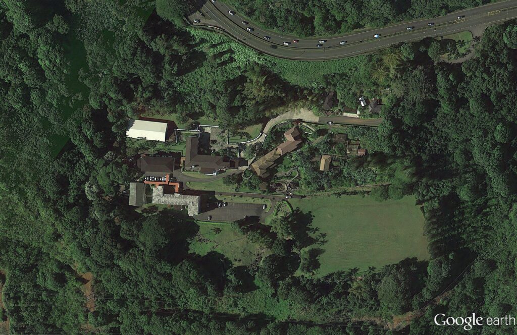
In 1927, Harold and his wife Alice Hedemann Castle built a home for themselves that overlooked much of their land holdings.  It was just below the hairpin turn, below the Pali.

They called the home Palikū (Lit., vertical cliff.)

Architect Bertram Grosvenor Goodhue designed it (Goodhue’s other work included Los Angeles Central Public Library, the Nebraska State Capitol and Saint Thomas Church, New York City;) there were 27 rooms with ornamental ironwork, redwood beams, plumbing and electricity – one of the first buildings on the windward side of the island to have those amenities. (Brennan, Honolulu Advertiser)

In 1946, the Castles sold the 22-acre Palikū to the Catholic Church for the Saint Stephen Seminary (the seminary closed in 1970; it’s now the St. Stephen’s Diocesan Center (the driveway is makai, just below the scenic lookout at the hairpin turn.))

St. Stephen’s Seminary was shut down for a time after a mysterious occurrence in October 1946.

Some suggest the seminary was haunted; when one night there were methodical clicking and tapping sounds; invisible pressure on a person in bed; dishes, pots and pans strewn all over – they suggest it was “diabolical obsession.”  Later, “I understand there was some kind of a blessing done,” said Bishop Joseph Ferrario, the retired bishop of Honolulu. (honoluluadvertiser)

After the seminary’s ultimate closure, the facility was transformed into a diocesan center housing various offices of the diocesan curia (a diocesan center (chancery) is the branch of administration which handles all written documents used in the official government of a Roman Catholic diocese.)

The former Castle home also serves as the residence of the Bishop of Honolulu, Clarence Richard Silva, popularly known as Larry Silva (born August 6, 1949), bishop of the Roman Catholic Church. He is the fifth Bishop of Honolulu, appointed by Pope Benedict XVI on May 17, 2005.

In 1962, Castle founded the Harold KL Castle Foundation. On his death in 1967, he bequeathed a sizeable portion of his real estate assets to the Foundation.

Throughout his life, Castle donated land for churches of all different denominations because he felt that churches would bring congregations, congregations would bring stability, and that would benefit the community that was growing around them.

Mr. Castle also donated land and money to Hawaii Loa College, Castle Hospital, ʻIolani School, Castle High School, Kainalu Elementary School and the Mōkapu peninsula land, which would become the Kāneʻohe Marine Corps Base.

His foundation has annually provided millions of dollars in support to worthy causes, a good chunk of it going to the windward side of Oʻahu.

© 2022 Hoʻokuleana LLC

Filed Under: Buildings, Prominent People, Economy Tagged With: Kailua, Kainalu, Harold Castle, Koolaupoko, Kaneohe Ranch, Windward, Mokapu, Paliku, Hawaii, Castle and Cooke, Oahu, Kaneohe

January 29, 2022 by Peter T Young Leave a Comment

Lāhainā Roads

It’s not about automobiles – this is the area where ships anchor off Lāhainā.

Lāhainā Roads, also called the Lāhainā Roadstead is a channel of the Pacific Ocean in the Hawaiian Islands. The surrounding islands of Maui and Lānaʻi (and to a lesser extent, Molokaʻi and Kahoʻolawe) make it a sheltered anchorage.

The central location of the Hawaiian Islands between the continent and Japan whaling grounds brought many whaling ships to the Islands.  Whalers needed food and the islands supplied this need from its fertile lands.

Between the 1820s and the 1860s, the Lāhainā Roadstead was the principal anchorage of the American Pacific whaling fleet.  During that time, up to 1,500 sailors at a time were on the streets of the small town.

One reason why so many whalers preferred Lāhainā to other ports was that by anchoring in a roadstead from half a mile to a mile from shore they could control their crews better than when in a harbor.

“This mountain barrier (West Maui Mountains) shuts off the trade wind, and Lahaina roadstead is as smooth as the proverbial millpond, though a brief time may bring the sailor to a wind-tossed portion of Neptune’s domain of a very different finality.”  (The Friend, April 1903)

“Four channels lead into this inland sea, from the north, from the west, from the south, and from the southeast, and each has its own significant name. The islands which make these channels are seen most comprehensively from the hill back of the town -“

“Molokai on the right, stretching westward; Lanai directly in front, blocking the ocean on the southwest; and Kahoolawe, long and low, on the left, running southwestward.”  (The Friend, April 1903)

“The anchorage being an open roadstead, vessels can always approach or leave it with any wind that blows.  No pilot is needed here.”

“Vessels generally approach through the channel between Maui and Molokai, standing well over to Lanai, as far as the trade will carry them, then take the sea breeze, which sets in during the forenoon, and head for the town.”  (The Friend, April 30, 1857)

“The anchorage is about ten miles in extent along the shore and from within a cable’s length of the reef in seven fathoms of water, to a distance of three miles out with some twenty-five fathoms, affording abundant room for as large a fleet as can ever be collected here.”  (The Friend, April 30, 1857)

“I shall never forget the finest sight of ships under sail I ever saw. It was a beautiful Sabbath morning at Lahaina. A very few ships were anchored off our place. The familiar cry of “Kail O!” was early heard and a glance towards the point towards Molokai revealed a ship under full sail coming down the channel.”  (Paradise of the Pacific, 1906 – referring to 1851-1861)

“It was soon followed by another and another until the increasing numbers ceased to be numbered. It was a fine sight as they came into view.  As if some common agreement they had all agreed to make the port the same time.  They had come from the Arctic and the Okhotsk sea”.  (Paradise of the Pacific, 1906 – referring to 1851-1861)

After whaling ended, the Roadstead continued to be used.

Since the 1930s, the US Navy had been using the Lāhainā roadstead between Maui and Lānaʻi as a protected deepwater anchorage for fleet deployment.

While the support facilities were limited on land, the location offered a convenient alternative to the crowded Pearl Harbor for temporary fleet basing.

Through the 1940s, Lāhainā Roads was as an alternative anchorage to Pearl Harbor.

While planning for the attack on the US Pacific Fleet, Japanese planners hoped that some significant units would be at anchor there because with Lāhainā’s deep water, those elements of the Pacific Fleet in all likelihood would never have been recovered.

The possibility that the Pacific Fleet would be at Lāhainā anchorage was taken seriously in the plan of the Japanese naval strike force for the attack on Pearl Harbor in 1941. Scout planes were dispatched from the fleet, and submarines were sent to Lāhainā Roads to inspect the anchorage.  (The ships were at Pearl Harbor.)

© 2022 Hoʻokuleana LLC

Filed Under: Economy, Sailing, Shipping & Shipwrecks Tagged With: Whaling, Maui, Pearl Harbor, Lahaina, Lahaina Roads, Lahaina Roadstead, Hawaii

January 26, 2022 by Peter T Young Leave a Comment

Kaʻahumanu Church

The church began on August 19, 1832; the first services were held under a thatched roof.

The present Kaʻahumanu Church is actually the fourth place of worship for the Wailuku congregation. The original congregation, under the leadership of the Reverend Jonathan S Green, was forced to hold their meetings in a shed.

During its first year, Queen Kaʻahumanu, the Kuhina Nui of the Kingdom and convert to Christianity, visited the congregation and asked that when the congregation built an actual church, it be named for her.

Queen Kaʻahumanu was Kamehameha’s favorite wife.  She was, at one time, arguably, the most powerful figure in the Hawaiian Islands, helping usher in a new era for the Hawaiian kingdom.

When Kamehameha died on May 8, 1819, the crown was passed to his son, Liholiho, who would rule as Kamehameha II.

Kaʻahumanu created the office of Kuhina Nui (similar to premier, prime minister or regent) and would rule as an equal with Liholiho.  She ruled first with Kamehameha II until his departure for England in 1823 (where he died in 1824) and then as regent for Kauikeaouli (Kamehameha III).

Ka‘ahumanu assumed control of the business of government, including authority over land matters, the single most important issue for the Hawaiian nation for many generations to come.  She later married Kauaʻi’s chief, Kaumualiʻi, who Kamehameha I had made a treaty with instead of fighting and thereby put all the islands under single control.

On December 4, 1825, Queen Kaʻahumanu was baptized and received her new name, Elizabeth, then labored earnestly to lead her people to Christ.

The congregation’s small shed meeting house soon proved too small as the service held there attracted as many as 3,000 worshippers. In 1834, a larger meeting house with a thatched roof was erected by the congregation.

The Reverend Richard Armstrong who had replaced the Reverend Green as pastor in 1836, supervised the construction of two stone meeting houses one at Haiku, and the other at Wailuku. The new Wailuku Church, completed in 1840, was 100 feet by 52 feet, and was two stories (actually one story and a gallery) in height.  Reverend Green returned to replace Armstrong in 1840.

In 1843, the Reverend Green was replaced by the Reverend EW Clark. Five years later, Clark was transferred to Kawaiahaʻo Church in Honolulu, and the Reverend Daniel Conde took over the pastorate at Wailuku.  Later, Reverend WP Alexander became pastor.

Active fundraising under Pastor William Pulepule Kahale led to the opportunity to finally build a permanent church.  Under the direction of Reverend Edward Bailey, in May, 1876, the new church, finally named the Kaʻahumanu Church, was completed.

Only a rock retaining wall that borders High Street in Wailuku is what remains of the old church.

The Kaʻahumanu Church is a large blue stone structure with wall more than two feet thick. It has a high-pitched gable roof with no overhang, but the eave terminates in a small molding adjacent to the top place along the wall.

The exterior is finished in plaster.  The church tower was not added until 1884 with a “fine tower clock from the U.S. costing $1,000.”  In 1892 the chandeliers were added to the interior.

The structure is four bays in depth with each bay having a single tall Gothic arched window with the interior of the window opening splayed.  Windows are multi-paned, double-hung wood frame with simple pattern in the upper part of the arch.

Adjoining the church is Honoliʻi Park.  It is believed that John Honoliʻi, a Native Hawaiian who had studied at Cornwall, Connecticut with Henry ʻŌpūkahaʻia and later sailed aboard the brig Thaddeus with the original Protestant missionaries in 1820, is buried in an unmarked grave in the Kaʻahumanu Church cemetery. (Honoliʻi died in 1838.)

© 2022 Hoʻokuleana LLC


Filed Under: Missionaries / Churches / Religious Buildings Tagged With: Hawaii, Maui, Kaahumanu, Wailuku, Kaahumanu Church, John Honolii, Wailuku Civic Center, Reverend Bailey

January 25, 2022 by Peter T Young Leave a Comment

Eleventh Century

There was conflict in various parts of the world …

It was nearing the end of the Heian period in Japan. The battle of Kawasaki was the first major battle of the Early Nine Years’ War (Zenkunen War) (1051-1063.) (The fighting lasted for twelve years (or nine if you subtract short periods of ceasefire and peace.))

The war was fought between the forces of the powerful Abe clan of the far northeast of the main island of Honshū, led by Abe no Sadato, and those of the Minamoto clan, acting as agents of the Imperial Court, and led by Minamoto no Yoriyoshi and his son Yoshiie.

In 1062, Minamoto no Yoriyoshi, along with his son, led an assault on an Abe fortress on the Kuriyagawa. They diverted the water supply, stormed the earthworks and stockade, and set the fortress aflame. After two days of fighting, Sadato surrendered.

At about this time, the seiitaishogun or shōgun became de facto rulers of Japan through powerful regional clans with support from samurai (bushi) serving as the military nobility.

Europe was at war as well; on September 28, 1066, William (William the Conqueror) of Normandy (Northern France) landed in England on Britain’s southeast coast, with approximately 7,000 troops and cavalry.

He then marched to Hastings; on October 14, 1066 William defeated King Harold (England) at the Battle of Hastings. After further military efforts, William was crowned king (the first Norman King of England) on Christmas Day 1066.

At the end of the century, Europe saw the first of the Crusades, launched on November 27, 1095 by Pope Urban II; it was a military expedition by Roman Catholic Europe to regain the Holy Lands taken in the Muslim conquests of the Levant, ultimately resulting in the recapture of Jerusalem in 1099. (Between 1095 and 1291 there were seven major crusades.)

Stuff was happening in the Pacific, as well.

Using stratigraphic archaeology and refinements in radiocarbon dating, recent studies suggest it was about this same time that “Polynesian explorers first made their remarkable voyage from central Eastern Polynesia Islands, across the doldrums and into the North Pacific, to discover Hawai‘i.” (Kirch)

“Most important from the perspective of Hawaiian settlement are the colonization dates for the Society Islands and the Marquesas, as these two archipelagoes have long been considered to be the immediate source regions for the first Polynesian voyagers to Hawai‘i. …”

“In sum, the southeastern archipelagoes and islands of Eastern Polynesia have a set of radiocarbon chronologies now converging on the period from AD 900–1000.” (Kirch)

Research indicates human colonization of Eastern Polynesia took place much faster and more recently than previously thought. Polynesian ancestors settled in Samoa around 800 BC, colonized the central Society Islands between AD 1025 and 1120 and dispersed to New Zealand, Hawaiʻi and Rapa Nui and other locations between AD 1190 and 1290. (Hunt; PVS)

With improved radiocarbon dating techniques and equipment to more than 1,400-radiocarbon dated materials from 47 islands, the model considers factors such as when a tree died rather than just when the wood was burned and whether seeds were gnawed by rats, which were introduced by humans. (PVS)

“There is also no question that at least O‘ahu and Kauai islands were already well settled, with local populations established in several localities, by AD 1200.” (Kirch)

Late and rapid dispersals explain remarkable similarities in artifacts such as fishhooks, adzes and ornaments across the region. The condensed timeframe suggests assumptions about the rates of linguistic evolution and human impact on pristine island ecosystems also need to be revised. (PVS)

While Europeans were sailing close to the coastlines of continents before developing navigational instruments that would allow them to venture onto the open ocean, voyagers from Fiji, Tonga and Samoa began to settle islands in an ocean area of over 10 million square miles.

The settlement took a thousand years and involved finding and fixing in mind the position of islands, sometimes less than a mile in diameter on which the highest landmark was a coconut tree. By the time European explorers entered the Pacific Ocean in the 16th century almost all the habitable islands had been settled for hundreds of years.

The voyaging was all the more remarkable in that it was done in canoes built with tools of stone, bone and coral. The canoes were navigated without instruments by expert seafarers who depended on their observations of the ocean and sky and traditional knowledge of the patterns of nature for clues to the direction and location of islands. (Kawaharada; PVS)

The canoe hulls were dug out from tree trunks with adzes or made from planks sewn together with a cordage of coconut fiber twisted into strands and braided for strength. Cracks and seams were sealed with coconut fibers and sap from breadfruit or other trees.

An outrigger was attached to a single hull for greater stability on the ocean; two hulls were lashed together with crossbeams and a deck added between the hulls to create double canoes capable of voyaging long distances.

The canoes were paddled when there was no wind and sailed when there was; the sails were woven from coconut or pandanus leaves. These vessels were seaworthy enough to make voyages of over 2,000 miles along the longest sea roads of Polynesia, such as the one between Hawai‘i and Tahiti.

And though these double-hulled canoes had less carrying capacity than the broad-beamed ships of the European explorers, the Polynesian canoes were faster: one of Captain Cook’s crew estimated a Tongan canoe could sail “three miles to our two.”

By the time Europeans arrived in Hawai‘i in the 18th-century, voyaging between Hawai‘i and the rest of Polynesia had ceased for more than 400 years, perhaps the last voyager being Pā’ao or Moʻikeha in the 14th-century. The reason for the cessation of voyaging is not known.

However, after the 14th-century, the archaeological evidence reveals a dramatic expansion of population and food production in Hawai‘i. Perhaps the resources and energies of the Hawaiian people went into developing their ‘āina; and ties with families and gods on the islands to the south weakened. (Kawaharada; PVS) (Lots of information here from Kirch, Kawaharada and Polynesian Voyaging Society.)

© 2022 Hoʻokuleana LLC

Filed Under: General, Ali'i / Chiefs / Governance, Hawaiian Traditions Tagged With: Hawaii, Canoe, Settlement

  • « Previous Page
  • 1
  • …
  • 262
  • 263
  • 264
  • 265
  • 266
  • …
  • 571
  • Next Page »

Images of Old Hawaiʻi

People, places, and events in Hawaiʻi’s past come alive through text and media in “Images of Old Hawaiʻi.” These posts are informal historic summaries presented for personal, non-commercial, and educational purposes.

Info@Hookuleana.com

Connect with Us

  • Email
  • Facebook
  • LinkedIn
  • Twitter
  • YouTube

Recent Posts

  • Lake Waiau
  • Silva’s Stores
  • Jones Act
  • Lady in Waiting
  • ‘For Manly Men’
  • Hawaiian Common Law
  • About 250 Years Ago … John Paul Jones

Categories

  • American Revolution
  • General
  • Ali'i / Chiefs / Governance
  • Buildings
  • Missionaries / Churches / Religious Buildings
  • Hawaiian Traditions
  • Military
  • Place Names
  • Prominent People
  • Schools
  • Sailing, Shipping & Shipwrecks
  • Economy
  • Voyage of the Thaddeus
  • Mayflower Summaries

Tags

Albatross Al Capone Ane Keohokalole Archibald Campbell Bernice Pauahi Bishop Charles Reed Bishop Downtown Honolulu Eruption Founder's Day George Patton Great Wall of Kuakini Green Sea Turtle Hawaii Hawaii Island Hermes Hilo Holoikauaua Honolulu Isaac Davis James Robinson Kamae Kamaeokalani Kameeiamoku Kamehameha Schools Lalani Village Lava Flow Lelia Byrd Liberty Ship Liliuokalani Mao Math Mauna Loa Midway Monk Seal Northwestern Hawaiian Islands Oahu Papahanaumokuakea Marine National Monument Pearl Pualani Mossman Quartette Thomas Jaggar Volcano Waikiki Wake Wisdom

Hoʻokuleana LLC

Hoʻokuleana LLC is a Planning and Consulting firm assisting property owners with Land Use Planning efforts, including Environmental Review, Entitlement Process, Permitting, Community Outreach, etc. We are uniquely positioned to assist you in a variety of needs.

Info@Hookuleana.com

Copyright © 2012-2024 Peter T Young, Hoʻokuleana LLC

Loading Comments...