Images of Old Hawaiʻi

  • Home
  • About
  • Categories
    • Ali’i / Chiefs / Governance
    • American Protestant Mission
    • Buildings
    • Collections
    • Economy
    • Missionaries / Churches / Religious Buildings
    • General
    • Hawaiian Traditions
    • Other Summaries
    • Mayflower Summaries
    • Mayflower Full Summaries
    • Military
    • Place Names
    • Prominent People
    • Schools
    • Sailing, Shipping & Shipwrecks
    • Voyage of the Thaddeus
  • Collections
  • Contact
  • Follow

February 11, 2023 by Peter T Young Leave a Comment

1783

“… at 5 o’clock we arrived there and saw a number of People, I believe between 2 and 300 … we still continued advancing, keeping prepared against an attack tho’ without intending to attack them … they fired one or two shots, upon which our Men without any orders rushed in upon them, fired and put ’em to flight; several of them were killed”. (Diary of Lt. John Barker, Library of Congress)

The first shot (“the shot heard round the world”) was fired just as the sun was rising at Lexington. The American militia were outnumbered and fell back; and the British regulars proceeded on to Concord.

On April 19, 1775, the Battles of Lexington and Concord were the first military engagements of the American Revolutionary War. The battles marked the outbreak of open armed conflict between the Kingdom of Great Britain and its thirteen colonies of British North America.

Following this, the Continental Congress adopted the Declaration of Independence and it was signed by 56-members of the Congress (1776.) The next eight years (1775-1783) war was waging on the eastern side of the continent. The main result was an American victory and European recognition of the independence of the United States.

The formal end of the war did not occur until the Treaty of Paris and the Treaties of Versailles were signed on September 3, 1783 and recognized the sovereignty of the United States over the territory bounded roughly by what is now Canada to the north, Florida to the south, and the Mississippi River to the west.

The treaty document was signed by John Adams, Benjamin Franklin and John Jay (representing the United States) and David Hartley (a member of the British Parliament representing the British Monarch, King George III.)

The last British troops left New York City on November 25, 1783, and the US Congress of the Confederation ratified the Paris treaty on January 14, 1784.

While the Colonists were battling the British, the Hawaiian Islands were divided into four chiefdoms: (1) the island of Hawaiʻi under the rule of Kalaniʻōpuʻu, who also had possession of the Hāna district of east Maui; (2) Maui (except the Hāna district,) Molokaʻi, Lānaʻi and Kahoʻolawe, ruled by Kahekili; (3) Oʻahu, under the rule of Kahahana; and at (4) Kauaʻi and Niʻihau, Kamakahelei was ruler.

Separate chiefdoms ruled separate parts of the Islands. However, conquest was in the air and battles and negotiations for power and control were going on.

In about 1781, through a well-planned campaign, Kahekili was able to regain possession of the Hāna district and this marked the beginning of the disintegration of Kalaniʻōpuʻu’s kingdom. (Kuykendall)

Kalaniʻōpuʻu died shortly thereafter (1782.) Before his death, Kalaniʻōpuʻu gave an injunction to Kiwalaʻo and Kamehameha, and to all the chiefs, thus: “Boys, listen, both of you. The heir to the kingdom of Hawaii nei, comprising the three divisions of land, Kaʻū, Kona and Kohala, shall be the chief Kiwalaʻo. He is the heir to the lands.” (Fornander)

“As regarding you, Kamehameha, there is no land or property for you; but your land and your endowment shall be the god Kaili (Kūkaʻilimoku.) If, during life, your lord should molest you, take possession of the kingdom; but if the molestation be on your part, you will be deprived of the god.” These words of Kalaniʻōpuʻu were fulfilled in the days of their youth, and his injunction was realized. (Fornander)

On Hawaiʻi Island, civil war broke out between Kīwalaʻō’s forces and the various chiefs under the leadership of Kamehameha. In the first major skirmish, the battle of Mokuʻōhai (a fight between Kamehameha and Kiwalaʻo in July, 1782 at Keʻei, south of Kealakekua Bay on the Island of Hawaiʻi,) Kiwalaʻo was killed.

The result of the battle of Mokuʻōhai was virtually to split the island of Hawaiʻi into three independent and hostile factions. The district of Kona, Kohala and portions of Hāmākua acknowledged Kamehameha as their sovereign. (Fornander)

The remaining portion of Hāmākua, the district of Hilo and a part of Puna, remained true to and acknowledged Keawemauhili as their Mōʻī; while the lower part of Puna and the district of Kaʻū, the patrimonial estate of Kīwalaʻō, ungrudgingly and cheerfully supported Keōua against the mounting ambition of Kamehameha. (Fornander)

On Maui, “At that time, Kahekili was plotting for the downfall of Kahahana and the seizure of Oʻahu and Molokaʻi, and the queen of Kauaʻi was disposed to assist him in these enterprises.” (Kalākaua)

Kahekili deceived Kahahana by having him believe Kaʻōpulupulu (his kahuna, priest) had offered the government and throne of Oʻahu to him (Kahekili), but that out of affection for his nephew he had refused; and he intimated strongly that Kaʻōpulupulu was a traitor to Kahahana.

Kahahana believed the falsehoods and it subsequently caused friction between Kahahana and Kaʻōpulupulu and the Oʻahu King turned a deaf ear to his kahuna’s advice and by the later part of 1782 or beginning of 1783, he arranged to have Kaʻōpulupulu killed.

Weakened, Kaʻōpulupulu commanded his wounded son, who had gained a point where a few steps would have placed him at the mercy of the angry sea: “E nui ke aho e kuʻu keiki a pa ke kino I ka ili kai a na ke kai ka ua ʻāina la” …

“Spend not your strength my son until your body strikes the surface of the ocean, for the land belongs to the sea.” This cryptic message culminated in the invasion of Oʻahu by Kahekili, aliʻi nui of Maui. (Nui; Cultural Surveys)

With his main obstacle removed, Kahekili prepared for an invasion against Oʻahu and Kahahana. He called on Kahahawai, his special friend, strategist and war chief. Kahekili’s warriors landed at Waikīkī in the beginning of 1783.

While Kahekili and his Maui army were camped near the heiau at ʻApuakehau, without authorization from Kahahana, the Eight of Oʻahu suddenly attacked the Maui warriors. The conflict was hand to hand, and in that respect was favorable to the eight men well-skilled in the use of spear and javelin.

Side by side, striking and smiting all before them, the little band forced its way into the heart of the body of its foes. It has been said that this was a fight “to which Hawaiian legends record no parallel.” Eight men attacked an army and for some time were victorious in their onslaught. (Westervelt)

Kahahana’s army was later routed, and he and his wife fled to the mountains. For nearly two years or more they wandered over the mountains, secretly aided, fed and clothed by his supporters. He was finally betrayed and killed by his wife’s brother. (Kanahele)

Kahekili and his eldest son and heir-apparent, Kalanikūpule, conquered Kahahana, adding Oʻahu under his control. (Kahekili’s son, Kalanikūpule, inherited his chiefdom; Oʻahu was later lost to Kamehameha in the Battle of Nuʻuanu (1795.))

The image shows a Herb Kane depiction of the sea portion of the land-sea battle of Mokuʻōhai.

© 2023 Hoʻokuleana LLC

Sea_battle_at_mokuohai-(HerbKane)

Filed Under: Ali'i / Chiefs / Governance, Hawaiian Traditions, Place Names Tagged With: Eight Of Oahu, Kalanikupule, 1783, Treaty of Paris, Hawaii, Kiwalao, Mokuohai, Kalaniopuu, Kamakahelei, Kahahana, Kamehameha

February 10, 2023 by Peter T Young Leave a Comment

Tsunami in Hawai‘i

A tsunami is a series of ocean waves generated by sudden displacements in the sea floor, landslides or volcanic activity.  In the deep ocean, the tsunami wave may only be a few inches high.  The tsunami wave may come gently ashore or may increase in height to become a fast moving wall of turbulent water several meters high.
 
In Hawaii, tsunamis have accounted for more lost lives than the total of all other local disasters.  In the 20th century, an estimated 221 people have been killed by tsunamis.  Most of these deaths occurred on the Big Island during the tsunamis of 1946 and 1960, two of the largest tsunamis to strike in the Pacific.
 
Here is a brief summary of some recent tsunami and their impacts in Hawai‘i:
 
1946
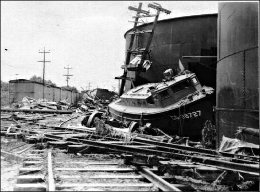
The tsunami of 1946 was generated by a magnitude 7.1 earthquake in the Aleutian Islands.  This tsunami struck the Big Island of Hawaii on April 1st.  The tsunami flooded the downtown area of Hilo killing 159 people and causing more than $26-million in damages.
 
1952
On November 4, 1952 a tsunami was generated by a magnitude 8.2 earthquake on the Kamchatka Peninsula in the USSR.  In Hawaii, property damage from these waves was estimated at $800,000-$1,000,000 (1952 dollars); no lives were lost.  The waves beached boats, caused houses to collide, destroyed piers, scoured beaches and moved road pavement.
 
1957
On March 9, 1957 a tsunami was generated by a magnitude 8.3 earthquake in the Aleutian Islands.  It generated a 24-foot tsunami that did great damage on Adak Island, especially to the fuel and oil docks.  The Hawaiian Islands incurred about $5,000,000 of damage in 1957 dollars.  The highest wave in Hawaii was 12-feet.
 
1960
The tsunami of May 23, 1960 was generated by a magnitude 8.3 earthquake in Chile.  The 35-foot tsunami struck Hilo, Hawaii causing severe damage.  61-deaths were recorded and $23-million in damage occurred.  In the area of maximum destruction, only buildings of reinforced concrete or structural steel and a few others sheltered by these buildings, remained standing – and even these were generally gutted.  Frame buildings were either crushed or floated nearly to the limits of the flooding.
 
1975
On November 29, 1975, an earthquake occurred off the coast of the Big Island of Hawaii.  When the quake-generated tsunami struck, 32 campers were at Halape Beach Park.  The sound of falling rocks from a nearby cliff, along with earth movement caused the campers to flee toward the ocean.  They were then forced back to the cliff by rising ocean waters.  The first wave was 5-feet high, but the second wave was 26-feet high and carried the unfortunate campers into a ditch near the base of the cliff, where they remained until the ordeal ended.  Two campers died and 19 suffered injuries.
 
2011
An earthquake measured at 9.0 magnitude, the sixth biggest since 1900, struck Japan on March 11, 2011.  The first tsunami waves reached Kaua‘i shortly after 3 a.m. and took about 30 minutes to sweep through the island chain.  Waves above 6-feet were recorded at Kahului on Maui and 3-feet at Haleiwa on the north shore of Oahu.  Lost homes, sunken boats, Kona Village Resort damage, and damaged piers and roads caused tsunami damage into the tens of millions of dollars; no one was killed or injured during the tsunami.
 
The earliest historical account of a Hawaii tsunami was from a 16th century Hawaiian chant that described a huge wave that struck the coast of Molokai.
 
The earliest confirmed tsunami was on Dec 21, 1812, when a wave from Southern California was observed at Ho‘okena on the west coast of the Big Island (Hawai‘i island). Maximum runups in excess of 15 m were measured for the 1946 and 1957 distant tsunamis and the 1975 local tsunami.
 
The record shows that damaging tsunamis from distant earthquakes reached Hawaii these years: 1837, 1841, 1868, 1869, 1877, 1883, 1906, 1918, 1923, 1933, 1946, 1957, and 1960. Other smaller tsunamis that caused no significant damage in Hawaii were generated by distant earthquakes in 1896, 1901, 1906, 1919, 1922, 1923, two in 1927, 1928, 1929, 1931, 1938, 1944, 1952, and 1964.
 
In a period of 157 years, a damaging or destructive tsunami struck the Hawaiian Islands on the average of once in every twelve years.
 
© 2023 Ho‘okuleana LLC

Filed Under: General Tagged With: Hawaii, Hilo, Tsunami, Kailua-Kona

February 8, 2023 by Peter T Young Leave a Comment

Currency Stamped with “HAWAII” during WWII

Like most people of his generation, my father saved stuff, especially “special” stamps, currency and coins – below is a $10 bill of his that he gave to me.
 
According to the Federal Reserve, with the start of World War II, the US started printing specialized military currency to provide economic stability for the US dollar in occupied countries.
 
In Hawaiʻi, the Treasury Department replaced all US currency with special issue notes as a precautionary measure in the event of a Japanese victory.
 
These notes were circulated only in Hawai‘i and their brown seals and serial numbers differentiated them from notes issued on the mainland.
 
Overprints of the word HAWAII were made; two small overprints to the sides of the obverse of the bill between the border and both the treasury seal and Federal Reserve Bank of San Francisco seal, and huge outlined HAWAII lettering dominating the reverse.
 
The hope was that, should there have been a Japanese invasion, the US Government could immediately declare any Hawai‘i-stamped notes worthless, due to their easy identification.
 
$1, $5, $10 and $20 San Francisco Reserve notes featured the seal and serial numbers that the Bureau of Engraving and Printing called the “Hawaiʻi Overprint” (from July 1942 until October 1944.)
 
Hawai‘i wasn’t the only place where special currency was distributed.  Similarly, special notes were issued for use by American troops during the invasion of North Africa in November 1942.
 
These notes were overprinted with distinctive yellow Treasury Seals to distinguish them from the regular Silver Certificates overprinted with blue seals.
 
Like the overprinted Hawai‘i notes, these distinctive certificates could be declared worthless if large amounts fell into enemy hands.
 
In addition to the Hawai‘i currency issued, the Bureau of Engraving and Printing produced or oversaw the private production of Allied military currency used in Italy, France, Austria, Germany and Japan during and after the war.
 
The Department of the Treasury redeems all genuine United States currency at face value only, and does not render opinions concerning the numismatic value of old or rare currencies.
 
However, numerous websites indicate premiums are being paid for these special bills.  (I am keeping mine as a reminder of my father.)
 
© 2023 Ho‘okuleana LLC

Filed Under: Military Tagged With: Hawaii, WWII, Currency

February 7, 2023 by Peter T Young Leave a Comment

Evolution of the Volcano House

All the known Hawaiian eruptions since 1778 have been at Mauna Loa and Kilauea Volcanoes, except for the 1800–1801 eruption of Hualālai Volcano on the west coast of Hawai‘i Island.

For the past 200 years, Mauna Loa and Kilauea have tended to erupt on average every two or three years, placing them among the most frequently active volcanoes of the world.

The individual Kilauea eruptions recorded historically are in addition to the nearly continuous eruptive activity within or near Halema‘uma‘u Crater, extending throughout the 19th century and into the early 20th century.

Simultaneous eruption of both volcanoes has been rare except at times when Kilauea was continuously active before 1924. The only post-1924 occurrence of simultaneous eruption was in March 1984, when activity at both volcanoes overlapped for one day.

Between 1934 and 1952, only Mauna Loa was active and, between 1952 and 1974, only Kilauea was. (Tilling)  Since July 1950, Hawaiian eruptive activity has been dominated by frequent and sometimes prolonged eruptions at Kilauea, while only a couple short lived eruptions have occurred at Mauna Loa (July 1975 and March-April 1984).

Except for the nearly continuous eruptive activity at Halema‘uma‘u for a century before 1924, and at Mauna Loa summit between 1872 and 1877, the Pu‘u ‘O‘o eruption became the longest lasting single Hawaiian eruption in recorded history.

“The wonderful volcano of Kīlauea, on the island of Hawaii, is the great attractive of visitors.  It is the only crater in the world that is constantly in action, and that can be safely approached at all times to the very edge of the precipice which encloses the boiling lava.”

“To reach Kīlauea necessitates a passage of thirty hours from Honolulu in a fine steamer to Hilo or Punalu‘u, then a ride of thirty miles in coaches takes visitors to a fine hotel, which overlooks the molten lava lake. It is a sight that will repay the effort and expense incurred ten times over, and one that will never be forgotten.” (Whitney)

The earliest structure associated with Volcano House can be traced back all the way to 1846 when Benjamin Pitman constructed a four walled thatched shelter “in the native style.” It was a simple, one-room 12-by-18-foot shelter made of grass and native ohia wood poles is built and later dubbed “Volcano House.” The name stuck.  (NPS)

The NPS records include a Volcano House Register, essentially a Guest Book; this started at Pitman’s Volcano House. Orramel H Gulick donated the first blank volume of the Volcano House Register. Gulick noted in the preface,

“Travelers and passersby are requested by the donor of this book to record their names in it and to note all, or any, volcanic phenomena that may come under their notice during their stay or at the time of their visit.  By so doing, this record may become of great value, some years hence, to the scientific world.”

The first entry of Volume 1 is dated February 8, 1864; here JB Swain starts, “Having been located in this vicinity for the year last past I have noticed that the volcano has been in greater activity the last month than at any time throughout the last year. Within the last few days jets of lava could be seen from the Volcano House during the day, a circumstance not before observed.”

Later (1866), a four-room wood frame, thatched-roof Volcano House replaced the original building. One of its early guests was Samuel Clemens (Mark Twain).

Mark Twain recounts his Volcano House stay in a November 16, 1866 Sacramento Daily Union article, “Neat, roomy, well furnished and a well kept hotel … The surprise of finding a good hotel at such an outlandish spot startled me, considerably more than the volcano did.”

Royal Geographical Society traveler Isabella Bird visited in 1872. Bird remarked “The inn is a grass and bamboo house, very beautifully constructed without nails.”

“It is a longish building with a steep roof divided inside by partitions which run up to the height of the walls. There is no ceiling. The joists which run across are concealed by wreaths of evergreens, from among which peep out here and there stars on a blue ground.”

In 1877, William Lentz, a carpenter from Baltimore, built a more permanent western-style Volcano House hotel; it was located on the flat area fronting the present Volcano Art Center.  King Kalākaua, Louis Pasteur and Robert Louis Stevenson are among its guests.

By 1891, the popularity of Volcano House hotel was booming. The hotel had traded hands again, this time to Lorrin A Thurston, a Honolulu businessman and controversial historic figure. Thurston formed the “Volcano House Company” in partnership with the steamship companies that operated in Hawaiʻi at the time.

In 1891, this partnership increased capacity of the hotel with a 2-story Victorian-style addition to the Ka‘ū side of the building. Even with the addition, space in the hotel was barely enough for demand. At times, the lodge was so crowded that the billiard table in the parlor would be used as a bed.

In 1912, Thomas Jaggar built the Hawaiian Volcano Observatory, which he located on edge of the crater (at the site of the existing Volcano House). The concrete vault of the observatory Jaggar was called the Whitney Laboratory of Seismology (named after Edward and Caroline Whitney, whose estate subscribed $25,000 for research into the science of volcanoes).

In 1921 the Volcano House grew again; in addition, the 1877 section of the building was removed from the 1891 Victorian addition and moved behind the new structure, back to where it currently is (the Volcano Art Center building).  A two-story wing was then added to the Victorian addition, bringing the number of rooms from 25 to 104.

A lack of tourism due to the Great Depression forced the company to sell the hotel at a sheriff’s auction.  George Lycurgus, sole bidder and a previous manager of the hotel, purchased the building for $300.

“Uncle George”, as he later became known, would go on to manage the hotel until his death in 1959. Lycurgus hosted celebrities such as Princess Victoria Ka‘iulani, President Franklin Delano Roosevelt and Amelia Earhart,

On February 7, 1940, tragedy struck; the Volcano House burnt to the ground. A kitchen fire raged out of control and claimed the entire building. The next day, Volcano House was open for business as the smaller 1877 building was pressed back into service to accommodate guests.

In 1941, NPS paid for the construction of a new 24-room wood-and-stone hotel; it is designed by noted architect Charles W Dickey.  The hotel was also relocated about 200 yards from its former site, across Crater Rim Drive on the caldera’s edge. (The 1941 Volcano House having been constructed over it.)

On November 8, 1941, the new hotel opened for business.  Over the years, the list of guests included Dwight D Eisenhower, Harry S. Truman, Dr. Charles W. Mayo, John F. Kennedy and Richard M. Nixon as well as many others.

The Park Headquarters (Administration Building) was built in June 1932; in 1949 it was turned over to the Volcano House Hotel. At that time, Lycurgus renamed the building the Ohia Wing and converted the interior into 10-guestrooms with private baths. In 1953, an eight-room wing was added to the main hotel building.

The legacy of this historic hotel continues. Today, the Volcano House Hotel has 33-guest rooms; in addition, the hotel manages 10 cabins and 16 campsites located at Nāmakanipaio Campground about 3-miles from the hotel.

As they have done for over centuries, people flock to Kīlauea to experience the wonder of nature at work. As it has always done, Volcano House Hotel provides a good meal and warm hearth to those that make the journey.

(In 1935, Ripley’s Believe It Or Not stated that the “fire in the fireplace in the Volcano House has been burning continuously for 61 years”; and, it continued to do so for many more years.  However, “the fabled fireplace was allowed to go out New Year’s Day 2010.” (Hawaii Magazine)) (Information here is from various documents of the NPS.)

© 2023 Ho‘okuleana LLC

Filed Under: General, Economy Tagged With: Hawaii, Volcano House, George Lycurgus

February 5, 2023 by Peter T Young Leave a Comment

Royal Residences

 
I have previously posted a number of images of some of the former Royal Residences in Hawai‘i.  This is not a complete listing, nor full set of images of these palaces, retreats and residences of Hawaiian royalty.
 
‘Iolani Palace
 
The Iolani Palace was built in 1882 by King David Kalakaua. His successor, Queen Liliuokalani, lived there until she was deposed in 1893.
 
The building was used as the capitol of the state of Hawaii until 1969, when it was restored and turned into a museum and state historic monument.
 
Hulihe’e Palace
 
The Hulihee Palace was built by Governor John Adams Kuakini in 1838, and until 1916 is was a vacation home for Hawaiian royalty. It is located on Ali‘i Drive in Kailua-Kona on the Big island of Hawaii.
 
Queen Emma’s Summer Palace
 
This home summer home of Queen Emma was called “Hanaiakamalama”. You can still see it today, just off the Honolulu end of the Pali Highway.
 
Washington Place
 
This home in the historic capital district of Honolulu was built by John Dominis and when his son (another John Dominis) married the future Queen Liliʻuokalani it was their home.
 
For many years it was used as the Governor’s mansion of Hawaii but today it is a museum that can be toured by the public.
 
Ainahau Estate in Waikiki
 
Ainahau was the name of the country home built on Waikiki land that was given to Princess Kaiulani when she was born.
 
Ainahau was built by Archibald Cleghorn for Princess Likelike and his daughter Princess Kaiulani. At first it was a country home but eventually it became their full-time home.
 
Ainahau was eventually sold to land investors and it was torn down in 1955 to make room for the Princess Kaiulani Hotel.
 
Keoua Hale
 
Keoua Hale was the palace of Princess Ruth Ke’elikōlani at 1302 Queen Emma Street in downtown Honolulu, Hawai’i. It was larger than Iolani Palace.
 
Moku‘ula
 
The Royal complex at Moku`ula was Lahaina’s “Sacred Island” situated in the middle of the 14 acre Mokuhinia Pond.
 
Located across the street from the ocean and 505 Front Street Shopping Center (near the intersection with Shaw Street), Moku`ula was both the sacred place for the seat of government and a sanctuary for the Hawaiian Royal families.
 
Kaniakapupu
 
Kaniakapupu (“the singing of the land shells”) is the now dilapidated summer palace of King Kamehameha III and his queen Kalama in upper Nu‘uanu, O‘ahu.

© 2023 Ho‘okuleana LLC

Filed Under: Ali'i / Chiefs / Governance, Buildings Tagged With: Royal Residences, Hawaii, Iolani Palace, Hulihee Palace, Keoua Hale, Kaniakapupu, Queen Emma Summer Palace, Washington Place, Ainahau, Mokuula

  • « Previous Page
  • 1
  • …
  • 212
  • 213
  • 214
  • 215
  • 216
  • …
  • 572
  • Next Page »

Images of Old Hawaiʻi

People, places, and events in Hawaiʻi’s past come alive through text and media in “Images of Old Hawaiʻi.” These posts are informal historic summaries presented for personal, non-commercial, and educational purposes.

Info@Hookuleana.com

Connect with Us

  • Email
  • Facebook
  • LinkedIn
  • Twitter
  • YouTube

Recent Posts

  • ʻĪmaikalani
  • About 250 years Ago … Give Me Liberty, Or Give Me Death
  • Herbert, William & Jack
  • Lake Waiau
  • Silva’s Stores
  • Jones Act
  • Lady in Waiting

Categories

  • Ali'i / Chiefs / Governance
  • Buildings
  • Missionaries / Churches / Religious Buildings
  • Hawaiian Traditions
  • Military
  • Place Names
  • Prominent People
  • Schools
  • Sailing, Shipping & Shipwrecks
  • Economy
  • Voyage of the Thaddeus
  • Mayflower Summaries
  • American Revolution
  • General

Tags

Albatross Al Capone Ane Keohokalole Archibald Campbell Bernice Pauahi Bishop Charles Reed Bishop Downtown Honolulu Eruption Founder's Day George Patton Great Wall of Kuakini Green Sea Turtle Hawaii Hawaii Island Hermes Hilo Holoikauaua Honolulu Isaac Davis James Robinson Kamae Kamaeokalani Kameeiamoku Kamehameha Schools Lalani Village Lava Flow Lelia Byrd Liberty Ship Liliuokalani Mao Math Mauna Loa Midway Monk Seal Northwestern Hawaiian Islands Oahu Papahanaumokuakea Marine National Monument Pearl Pualani Mossman Quartette Thomas Jaggar Volcano Waikiki Wake Wisdom

Hoʻokuleana LLC

Hoʻokuleana LLC is a Planning and Consulting firm assisting property owners with Land Use Planning efforts, including Environmental Review, Entitlement Process, Permitting, Community Outreach, etc. We are uniquely positioned to assist you in a variety of needs.

Info@Hookuleana.com

Copyright © 2012-2024 Peter T Young, Hoʻokuleana LLC

Loading Comments...