Images of Old Hawaiʻi

  • Home
  • About
  • Categories
    • Ali’i / Chiefs / Governance
    • American Protestant Mission
    • Buildings
    • Collections
    • Economy
    • Missionaries / Churches / Religious Buildings
    • General
    • Hawaiian Traditions
    • Other Summaries
    • Mayflower Summaries
    • Mayflower Full Summaries
    • Military
    • Place Names
    • Prominent People
    • Schools
    • Sailing, Shipping & Shipwrecks
    • Voyage of the Thaddeus
  • Collections
  • Contact
  • Follow

March 4, 2022 by Peter T Young Leave a Comment

Kīpapa Gulch

Place names help tell the stories of the place.

During the reign of Māʻilikūkahi, who ruled at about the same time Christopher Columbus crossed the Atlantic, invaders from Hawai‘i and Maui arrived on O‘ahu.

In the battles, the O‘ahu forces met the opposing forces in the uplands of Waipi‘o, and a great battle occurred.

Māʻilikūkahi was raised partly in Waialua and is said to have maintained a kulanakauhale (village) there.

Fornander writes, “He (Māʻilikūkahi) caused the island to be thoroughly surveyed, and boundaries between differing divisions and lands be definitely and permanently marked out, thus obviating future disputes between neighboring chiefs and landholders.”

Kamakau tells a similar story, “When the kingdom passed to Māʻilikūkahi, the land divisions were in a state of confusion; the ahupuaʻa, the ku, the ʻili ʻāina, the moʻo ʻāina, the pauku ʻāina, and the kihāpai were not clearly defined.”

“Therefore, Māʻilikūkahi ordered the chiefs, aliʻi, the lesser chiefs, kaukau aliʻi, the warrior chiefs, puʻali aliʻi, and the overseers (luna) to divide all of Oʻahu into moku, ahupuaʻa, ʻili kupono, ʻili ʻāina, and moʻo ʻāina.”

What is commonly referred to as the “ahupuaʻa system” is a result of the firm establishment of palena (boundaries.) This system of land divisions and boundaries enabled a konohiki (land/resource manager) to know the limits and productivity of the resources that they managed – and increase its productivity.

Māʻilikūkahi is also known for a benevolent reign that was followed by generations of peace. He prohibited the chiefs from plundering the makaʻāinana, with punishment of death. His reign “ushered in an era of benign rule lasting for several generations.”

Thrum notes that while Māʻilikūkahi was peacefully disposed, he proved to be a brave defender of his realm in thoroughly defeating the invading forces.

Fornander suggests it was not considered a war between the two islands, but, rather, it was a raid by some restless and turbulent chiefs. The invading force first landed at Waikīkī and proceeded to ʻEwa and marched inland.

At Waikakalaua (an upland ʻili of Waikele) they met Māʻilikūkahi and his forces, and a bloody battle ensued. The fight continued from there to the Kīpapa gulch – stretching across Kīpapa (an ʻili of Waipiʻo,) Waikakalaua and the place known as Punaluʻu.

Tradition has it that the body count from the invaders was so great that it is said the area was paved (kīpapa “placed prone”) with their bodies.

Punaluʻu, an upland ʻili, was named for one of the invading warrior-chiefs killed during the battle. Another warrior-chief, Hilo, was also killed in the battle.

Poʻohilo (an ʻili of Honouliuli) is named from events following a battle in the Kīpapa-Waikakalaua region in which the head of Hilo was placed on a stake at this site and displayed.

Kanupo‘o (an ʻili of Waikele) may be translated as meaning, “planted skull” and seems to imply an event of some importance – it may be tied to events of the battle at Kīpapa and the naming of Po‘ohilo at Honouliuli.

Today, people suggest the gulch is ruled by the spirits of fallen warriors; there are reports that this is one of the paths of the Huakaiʻpo (night marchers) and other reports suggest a woman dressed in white hitchhiking.

The area was also a temporary home to the Naval Air Station Kipapa Field / Kipapa Army Airfield. It was used because it could accommodate two 5,000′ runways free from obstructions (however, concerns were raised about increased air congestion due to its proximity between Pearl Harbor and Wheeler Field.)

The airfield site is located south the Mililani Golf Course between Meheula Parkway and Hokuala Streets – the runways extended out to the edge of the gulch. Mililani District Park is located near the intersection of the 2 main runways.

The use of this site by the Navy would permit the concentration of carrier-group training for Naval aviation on the south side of the island of Oahu including Barber’s Point, Kīpapa Gulch, and Ford Island.

But it was not until sometime after the United States entered World War II that Kipapa Airfield was developed; the exact start date is not clear, but 1943 maps note the facility.

During the war it apparently saw little use by the Navy due to the fact that carrier aircraft were constantly deployed during the war. The Army Air Corps became the principal user of the airfield by default.

Aircraft from this airfield searched & patrolled over the surrounding Pacific area, maintaining a 24-hour vigil to avert any attack with a large number and variety of squadrons are documented to have been stationed at Kipapa Airfield during World War II.

Kipapa Field was evidently closed at some point between 1959 and 1961 (it was no longer depicted on the 1961 and later mapping.)

© 2022 Hoʻokuleana LLC

Filed Under: Place Names Tagged With: Huakaipo, Hawaii, Oahu, Mailikukahi, Ahupuaa, Ewa, Waikele, Kipapa, Night Marchers, Mililani

March 3, 2022 by Peter T Young 4 Comments

Surfer Girl

“Surf-riding was one of the most exciting and noble sports known to the Hawaiians, practiced equally by king, chief and commoner. It is still to some extent engaged in, though not as formerly, when it was not uncommon for a whole community, including both sexes, and all ages, to sport and frolic in the ocean the livelong day.” (Malo)

By 1779, riding waves lying down or standing on long, hardwood surfboards was an integral part of Hawaiian culture. Surfboard riding was as layered into the society, religion and myth of the islands as baseball is to the modern United States.

Even the missionaries surfed.

Amos Cooke, who arrived in Hawaiʻi in 1837 – and was later appointed by King Kamehameha III to teach the young royalty in the Chief’s Childrens’ School – surfed himself (with his sons) and enjoyed going to the beach in the afternoon. “After dinner Auhea went with me, & the boys to bathe in the sea, & I tried riding on the surf. To day I have felt quite lame from it.” (Cooke)

Mark Twain sailed to the Hawaiian Islands and tried surfing, describing his 1866 experience in his book Roughing It. “I tried surf-bathing once, subsequently, but made a failure of it. I got the board placed right, and at the right moment, too; but missed the connection myself.”

“The board struck the shore in three quarters of a second, without any cargo, and I struck the bottom about the same time, with a couple of barrels of water in me.”

Missionary Hiram Bingham, noted of surfing (rather poetically,) “On a calm and bright summer’s day, the wide ocean and foaming surf … the green tufts of elegant fronds on the tall cocoanut trunks, nodding and waving, like graceful plumes, in the refreshing breeze …”

“… the natives … riding more rapidly and proudly on their surf-boards, on the front of foaming surges … give life and interest to the scenery.”

Although everyone, including women and children, surfed, it was the chiefs who dominated the sport. One of the best among Waikīkī’s chiefs was Kalamakua; he came from a long ancestry of champion surfers whose knowledge, skill and mana were handed down and passed on from generation to generation. (DLNR)

A notable wahine (woman) surfer was Kelea, sister of Kawao, King of Maui (about AD 1445) – “No sport was to her so enticing as a battle with the waves.” (Kalākaua)

She loved the water possibly because she could see her fair face mirrored in it – and became the most graceful and daring surf-swimmer in the kingdom. Kelea later married Kalamakua. (Kalākaua) But this story is not about Kelea.

This story is about another surfer girl.

Reportedly, Mrs James Cromwell became the first woman to take up competition surfing under the guidance of surfing champion and Olympic swimmer Duke Kahanamoku and his brothers.

Cromwell won “First Place” in a surfboard regatta staged at Waikīkī Beach (January 22, 1939.) She and beach boy Sam Kahanamoku won the tandem, open “malihini girls and beach boys” quarter-mile sprint. (Honolulu Advertiser, January 23, 1939)

She and Sam were a familiar team in Waikīkī, where they won tandem surfing and paddling competitions. A bronze medalist in the 100-meter free-style swim at the 1924 Olympics, Sam was also an avid surfer, paddler, musician and a great wit. (Their friendship continued until his death in 1966.)

By 1941, Cromwell had 13-boards in the household inventory. Each of the boards had a name or initials, including one named Lahilahi (thin or dainty,) an affectionate nickname given to her by the Kahanamokus.

All was not fun and games. Showing her husband her surfing skill while in Honolulu, Mrs Cromwell, in 1935, had a slight scalp wound as a result of being thrown from her 60-pound surfboard. An emergency hospital record showed she was treated and released. (St Petersburg Times, November 3, 1935)

She later had a more modern board, created by Dale Velzy, who is considered one of the men responsible for the rise of the California surfer culture in the years following World War II. Some suggest Velzy opened the first conventional surf shop at Manhattan Beach in California in 1949.

Her board is one of the first boards Velzy created using the new polyurethane foam material; boards were previously made of balsa wood.

Oh, by the way … Mrs Cromwell was more generally known as “the richest girl in the world,” Doris Duke.

Doris Duke, the only child of James Buchanan Duke, was born on November 22, 1912. Her father was a founder of the American Tobacco Company and the Duke Power Company, as well as a benefactor of Duke University. When Mr Duke died in 1925, he left his 12-year old daughter an estate estimated at $80-million.

In the late-1930s, Doris Duke built her Honolulu home, Shangri La, on 5-acres overlooking the Pacific Ocean and Diamond Head. Shangri La incorporates architectural features from the Islamic world and houses Duke’s extensive collection of Islamic art, which she assembled for nearly 60-years.

Her surfing legacy lives on.

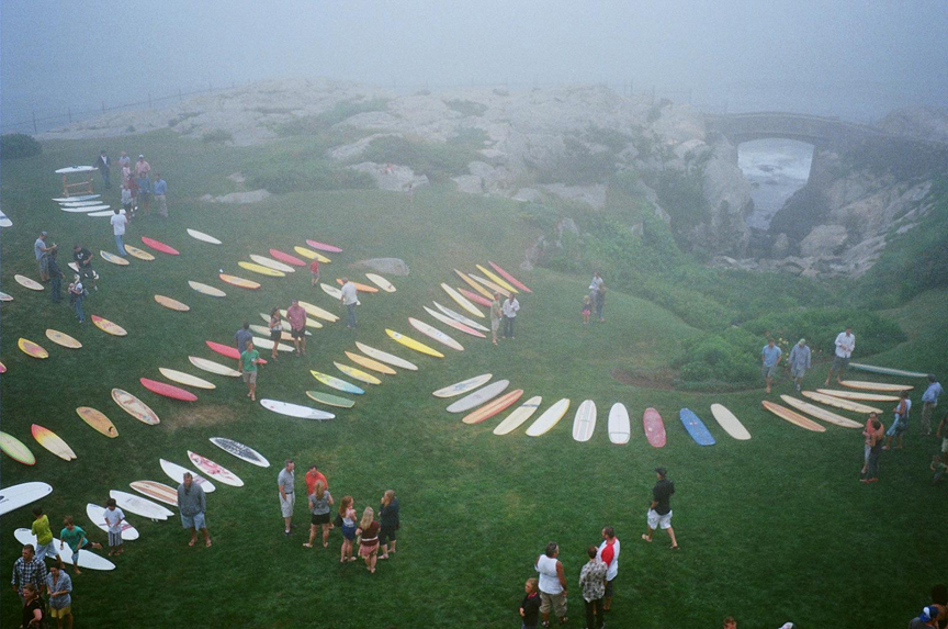
Rough Point has been the ‘home’ of the Doris Duke Surf Fest. It’s not really a surf contest; it’s more of a display of vintage surfboards on the grounds of Rough Point, one of Duke’s other homes (in Newport, Rhode Island, not far from the International Tennis Hall of Fame.)

Designed in the English manorial style, Rough Point was originally built for Frederick W Vanderbilt, sixth son of William H Vanderbilt. When it was commissioned in 1887, Rough Point was the largest house that the Newport summer colony had yet seen, replacing two wood-frame houses at the extreme southeast end of Bellevue Avenue.

Duke’s father bought it in 1922. On her death, she bequeathed the estate to the Newport Restoration Foundation with the directive that it be opened to the public as a museum (it opened for tours in 2000.) (Lots of information here from Shangri La Hawaiʻi and Newport Restoration Foundation.)

© 2022 Hoʻokuleana LLC
 

Filed Under: Place Names, Prominent People Tagged With: Kalamakua, Hawaii, Oahu, Surfing, Shangri La, Doris Duke, Rough Point, James Cromwell, Kelea

March 2, 2022 by Peter T Young Leave a Comment

Sugar in Hawai‘i in 1915

“Sugar is the commercial life blood of Hawai‘i. There are 46,000 persons actually on the pay roll of the Hawaiian sugar plantations, with twice as many more directly dependent on the industry, and almost the entire population indirectly dependent thereon.”

“It takes, with a few exceptions, from eighteen to twenty-four months, and on the higher lands, as many as thirty months to make a crop, instead of a year, as is the case in almost every other sugar country, with the consequent increase of cost …”

“… for all expense of upkeep and overhead charges for the longer time must come out of one crop. There are always two crops in the ground, and during several months of the year, three, all under care.”

“With the exception of certain districts, Hawai‘i is too dry to produce sugar cane without artificial irrigation. The cane from which one half of the sugar output is produced has to be irrigated every week or ten days. One-third of the employees of irrigated plantations are continuously engaged in watering the cane.”

“There is more water used per day for irrigating cane in Hawai‘i, than the daily . capacity of the New York aqueduct – 700,000,000 gallons.”

“Sixty per cent of the cost of sugar in Hawai‘i is for labor; and on sugar plantations in Hawai‘i, laborers are better and more expensively cared for, and are paid more than in any other cane producing country.”

“Under the United States coastwise shipping law, Hawaii is compelled to use high priced American ships only, to carry freight to and from the mainland; while other sugar producing countries can use the cheap freight rates of foreign shipping.”

“The opening of the Panama Canal has reduced the freight rate on sugar, from Hawai‘i to New York, from $9.50 to $8.50 per ton, and it may go somewhat lower; but the freight on Cuban sugar to New York, Hawai‘I’s chief competitor, is only $2.50 per ton.”

“The average cost of marketing a ton of Hawaiian sugar, covering freight, insurance, charges and commissions, is from $10 to $15 per ton.”

“The freight on merchandise from New York to Hawai‘i ranges from $8 to $20 per ton. The canal has reduced the rate by an average of about ten per cent. Later the reduction may be somewhat increased.”

“Hawaii has to plant cane anew about every third crop. In Cuba they are said to be still harvesting cane growing from cuttings planted by the grandfathers of the present sugar planters. It is common to continue harvesting annually in Cuba from cane planted ten to twenty years before.”

“There are other minor handicaps to Hawai‘I’s disadvantage, among them that Hawaii is so bedeviled with insect pests, and cane diseases …”

“… and the problems of meeting the naturally adverse conditions are so ever pressing and imperative, that the Hawaiian sugar planters are compelled to maintain, at their own expense, an experiment station, demonstration farm and corps of scientists that cost from $80,000 to $160,000 per annum.”

“The foregoing partially explains why it costs more to produce sugar in Hawai‘i than in any other sugar producing country in the world, except on the mainland of the United States.”

“The great world sugar producers, Cuba, Java and the European beet sugar countries; have cheap material, cheap labor and cheap freights.”

“Hawai‘i is inside the sacred circle of the American tariff, with its resulting higher basis of cost as to everything which enters into the production of sugar.”

“If it, too, can receive reasonable protection, it can continue, and better its past magnificent record of development; but it cannot buy and produce in a protected market and sell in the open market.”

“In this respect, Hawai‘i is in the same boat with the cane sugar industry of Louisiana and the beet sugar producers of the North and West.”

“Although Hawaii has some advantages over them, they also have advantages over the sugar producer in Hawai‘i, such as cheaper material, cheaper freights and near-by market.”

“There are forty-five complete sugar plantations in Hawai‘i. They are nearly all incorporated and owned by thousands of stockholders.”

“Twenty-four of these are listed on the stock exchange, and their financial affairs are open to all. They are a fair representation of the whole.” (Thurston, History of the Panama Canal, 1915) (Images from Babcock – 1926)

© 2022 Hoʻokuleana LLC

5221
5220
5206
5207
5208
5209
5210
5211
5212
5213
5214
5215
5216
5217
5218
5219
5222
5223
5224
5225
5226
5227

Filed Under: General, Economy Tagged With: Hawaii, Sugar

March 1, 2022 by Peter T Young Leave a Comment

Tour of Oʻahu – Feb/Mar 1818

James Hunnewell’s Journal covering portions of February and March of 1818 gives some descriptions of his tours on Oahu.

“Thursday, 12. In the morning rainy and dull, but clearing – away; at 10 a. m. left Hanarura in company with two white men and ten Indians, and traveled on a bad road through Palamar, Crehee (Kalihi), Monaraah (Moanalua), Halavar (Halawa), etc.

“In the course of the day we traveled through some beautiful valleys, well cultivated, and watered by small streams, and with some barren hills. At night we stopped at some huts, the residence of a white hermit (Moxley). We took refreshments and it coming on to rain, we put up for the night.

“Friday, February 13. Clearing away in the morning we continued our journey a short distance till we came to a river, which I had to swim (Waiawa). We then came into an uncultivated country, and in the course of the day saw but few huts; we crossed a number of small rivers.

“At dark arrived at Wyaruah (Waialua), and was sent for by the head chief of the place, and treated with fish and powie, and was accommodated with lodging in his own sleeping house.

“Saturday, 14th. Pleasant and clear. After refreshments we took leave of our new friends, traveled along the sea coast, and at noon arrived at Wymaah (Waimea), where stopped the remainder of the day to rest and refresh ourselves. We were here treated with a hog, some dogs, and potatoes. We took lodging here, but fleas were too plenty for sleep.

“Sunday, 15th, pleasant in the morning. Walked around the valley and visited the most remarkable places (some were caves in the rocks, and the spot where the missionaries were killed). [Lieut. Hergest and Mr. Gooch, an astronomer of the British ship ‘Daedalus,’ were murdered at Waimea in 1792.]

“At 10 a. m. took leave of Wymaah and continued our journey as far as [?]ipiruah, where we arrived before night and found the natives very poor, but they, however, brought two roasted dogs and some potatoes, and we put up for the night.

“Monday, 16th. Pleasant and clear. We went a short distance and got a small hog and some taro, and stopped till near noon, and then continued our journey along the sea coast under a ridge of mountains.”

“In the course of the day passed a number of small Indian settlements, some spots of cultivated land, but most of it lying waste. In rain at sundown arrived at a place called Punaru (Punaluu); took refreshments and put up for the night. The first part of the night many natives came to visit us.

“Tuesday, 17th. Pleasant and clear. At sunrise took leave of Punaru and traveled over hills and plains as far as Tahanah (Kahana), and took refreshments.

“Traveled around a long mountain, on the beach, to a place called Ta’aharvah (Kaaawa), and made another stop to rest and refresh, and then proceeded along the sea coast till dark, when we arrived at a place called Whyha (Waihee), and put up for the night; coming on to rain heavily we had little company for the night.

“Wednesday, 18th. Clearing away in the morning. We left Whyha and traveled inland over hills and plains for about ten miles, and stopped under trees to rest and refresh our selves.

“From this we began to ascend the Fall of Nawaur (Nuuanu), which is a precipice of about a thousand feet, nearly perpendicular. From this we traveled through a thick wood for a number of miles when we arrived in sight of Hanarura. We got into the village before sundown.

Another excursion, lasting for a week, was made in March, the account of which is as follows:

“Tuesday, March 24, 1818. At 2 a. m. hove out and found it raining. At 4 it continued raining, when I started from Hanarura in company with two white men and seven Indians, and traveled by moonlight.

“At sunrise we found ourselves in Mownaruah, when it held up raining. At 10, it cleared away pleasant. We stopped to see a chief by the name of Keikuavah (Keikioewa); he gave us a small hog, some fish and taro.

“After resting here we continued our journey. In the afternoon arrived at Waikelie (Waikele), at the residence of a white man by the name of Hunt. We here put up for the night.

“Wednesday, 25th. Pleasant and clear. I found myself very tired – stiff by traveling in the rain over a bad road, so we spent the day here in resting ourselves, and walking out to see the country, some of which I found cultivated, but mostly in waste.

“Thursday, 26th. Pleasant and clear. At 2 a. m. we left our white friend, and continued our journey by moonlight over an extensive plain to a high mountain, and at the dawn of day arrived at the top. (At the Kolekole Pass.)

“The mountains on each side are thickly wooded and full of singing birds, which are very melodious. After descending the mount and traveling over level country we arrived at the seashore at a place called Kohedeedee (deedee-liilii), which is a barren and sandy place. Stopped here for the night.

“Friday, 27th. Pleasant and clear. We went along the seashore as far as Whyany (Waianae) village, where we found a chief of our acquaintance who treated us well and accommodated us at his house, where we spent the remainder of the day, and the night.

“Saturday, 28th. Clear and pleasant; the weather hot. Spent the day in and about the village, making our home at the house of our friend. Whyany is a beautiful valley. In the centre is a large grove of cocoanut trees. It was formerly the residence of the king of this island. The ruins of the old morais are hardly visible.

“Sunday, 29th. Warm and pleasant. In the morning, going in to bathe I struck my head against a stone and cut it considerably. [He always retained the mark] Spent the heat of the day at the house, and in the afternoon walked as far as Koheedeedee and stopped for the night.

“Monday, 30th. Warm and pleasant. At 4 a. m. started for home by way of the sea-coast, which we found barren and sandy. In the course of the morning passed a number of Indian villages.

“We stopped on a place at the foot of a ridge of mountains to rest and refresh. We afterwards continued our journey over an extensive waste plain, in the burning sun, until noon, when we passed a number of valleys inhabited and cultivated.

“Stopped at Whikelie (Waikele), took refreshments, and continued our journey till dark. Stopped at some Indian houses for the night.

“Tuesday, 31st. Pleasant. At 4 a.m. started again by moonlight, and in the forenoon arrived at Hanarura.”

Note, in part, that his reference to ‘Indians’ uses a designation as old as the days of Columbus, when natives of the western world were supposed to be of India, and the name thus once given has not even yet been discontinued.

© 2022 Hoʻokuleana LLC

Oahu-Island-Emerson-Reg0445 (1833)

Filed Under: General Tagged With: Hawaii, Oahu, James Hunnewell, Timeline, 1818

February 27, 2022 by Peter T Young 1 Comment

Marianne Cope

“I am hungry for the work. … I am not afraid of any disease, hence it would be my greatest delight even to minister the abandoned ‘lepers.’”

Farmers Peter and Barbara Koob had five children in Germany and five children in the United States.  On January 23, 1838, their daughter, Barbara Koob (variants: Kob, Kopp and now officially Cope,) was born in the German Grand Duchy of Hess-Darmstadt.   The next year, the family immigrated to the United States to seek opportunity.

The Koob family settled in Utica, New York and became members of St. Joseph Parish, where the children attended the parish school.

In 1848, young Barbara received her First Holy Communion and was confirmed at St. John Parish in Utica when, in accordance with the practice of the time, the bishop of the diocese came to the largest church in the area to administer these two sacraments at the same ceremony.

After her father’s death, Barbara, in August, 1862, entered the Sisters of the Third Order of Saint Francis in Syracuse, NY, and, on November 19, 1862, she was invested at the Church of the Assumption. She soon became known as Sister Marianne.

As a member of the governing boards of her religious community, she participated in the establishment of two of the first hospitals in the central New York area, St. Elizabeth Hospital in Utica (1866) and St. Joseph’s Hospital in Syracuse (1869). These two hospitals were among the first 50 general hospitals in the US.

Sister Marianne began her new career as administrator at St. Joseph’s Hospital in Syracuse, NY in 1870 where she served as head administrator for six of the hospital’s first seven years.

In 1877, Sister Marianne was elected Mother General of the Franciscan congregation and given the title “Mother” as was the custom of the time.

In 1883, she received a letter from Father Leonor Fouesnel, a missionary in Hawaiʻi, to come to Hawaiʻi to help “procure the salvation of souls and to promote the glory of God.”

Of the 50 religious communities in the US contacted, only Mother Marianne’s Order of Sisters agreed to come to Hawaiʻi to care for people with Hansen’s Disease (known then as leprosy).

The Sisters arrived in Hawaiʻi on November 8, 1883, dedicating themselves to the care of the 200-lepers in Kakaʻako Branch Hospital on Oʻahu.  This hospital was built to accommodate 100-people, but housed more than 200.

The condition at the hospital were deplorable.  Each Sister-nurse learned to wash the wounds, to apply soothing ointment to the wounds, and to bring a sense of order to the lawlessness that prevails when there is abandonment of hope.

In 1884, Mother Marianne Cope and the Sisters of St. Francis came to Maui and with a royal bequest from Queen Kapiʻolani, established Malulani Hospital (“Protection of Heaven”) in Wailuku, next to the site of St. Anthony’s Church.  Malulani was the first hospital established on Maui.

In 1885, realizing that healthy children of leprous patients were at high risk of contracting the disease, yet had no place to live, she founded Kapiʻolani Home on Oʻahu for healthy female children of leprosy patients.  Because of her work, she was the recipient of the Royal Medal of Kapiʻolani.

In the summer of 1886, the Sisters took care of Father Damien (later Saint Damien) when he visited Honolulu during his bout with leprosy.  He asked the Sisters to take over for him when he died.

Mother Marianne led the first contingent of Sister-nurses to Kalaupapa, Molokaʻi, where more than a thousand people with leprosy had been exiled.  Upon arrival, on November 14, 1888, she opened the CR Bishop Home for homeless women and girls with Hansen’s Disease.  To improve the bleak conditions, Mother Marianne grew fruits, vegetables and landscaped the area with trees, thus creating a better environment among the residents.

While at Kalaupapa, Mother Marianne predicted that no Franciscan Sister would ever contract leprosy. Additionally she required her sisters use stringent hand washing and other sanitary procedures.

Upon the death of Saint Damien on April 15, 1889, Mother Marianne agreed to head the Boys Home at Kalawao.  The Board of Health had quickly chosen her as Saint Damien’s successor and she was thus enabled to keep her promise to him to look after his boys.

The Boys Home at Kalawao was completely renovated between 1889 – 1895 during her administration.  During the renovation, it was renamed Baldwin Home by the Board of Health in honor of its leading benefactor, HP Baldwin.

The two new Sisters who came to run the Home were accompanied on their boat journey by poet Robert Louis Stevenson, who stayed for a week.  During his stay, he wrote a poem for Mother Marianne and later donated a piano so that “there will always be music.”

Mother Marianne’s spirit of self-sacrifice enabled her to live and work with leper patients for 35 years.  Although there was not yet a cure, the Sisters could offer the lepers some semblance of dignity and as pleasant a life as possible.

Mother Marianne died in Kalaupapa on August 9, 1918.  The Sisters of St. Francis continue their work in Kalaupapa with victims of Hansen’s Disease.  No sister has ever contracted the disease.

On December 19, 2011, Pope Benedict signed and approved the promulgation of the decree for her sainthood and she was canonized on October 21, 2012.  (Information here is primarily from Cathedral of Our Lady of Peace.)

© 2022 Hoʻokuleana LLC

Filed Under: Missionaries / Churches / Religious Buildings, Prominent People Tagged With: Hawaii, Oahu, Molokai, Kakaako, Saint Damien, Kalaupapa, Kalawao, Saint Marianne

  • « Previous Page
  • 1
  • …
  • 201
  • 202
  • 203
  • 204
  • 205
  • …
  • 562
  • Next Page »

Images of Old Hawaiʻi

People, places, and events in Hawaiʻi’s past come alive through text and media in “Images of Old Hawaiʻi.” These posts are informal historic summaries presented for personal, non-commercial, and educational purposes.

Info@Hookuleana.com

Connect with Us

  • Email
  • Facebook
  • LinkedIn
  • Twitter
  • YouTube

Recent Posts

  • “Pele’s Grandson”
  • Bahá’í
  • Carriage to Horseless Carriage
  • Fire
  • Ka‘anapali Out Station
  • Lusitana Society
  • “Ownership”

Categories

  • Place Names
  • Prominent People
  • Schools
  • Sailing, Shipping & Shipwrecks
  • Economy
  • Voyage of the Thaddeus
  • Mayflower Summaries
  • American Revolution
  • General
  • Ali'i / Chiefs / Governance
  • Buildings
  • Missionaries / Churches / Religious Buildings
  • Hawaiian Traditions
  • Military

Tags

Albatross Al Capone Ane Keohokalole Archibald Campbell Bernice Pauahi Bishop Charles Reed Bishop Downtown Honolulu Eruption Founder's Day George Patton Great Wall of Kuakini Green Sea Turtle Hawaii Hawaii Island Hermes Hilo Holoikauaua Honolulu Isaac Davis James Robinson Kamae Kamaeokalani Kamanawa Kameeiamoku Kamehameha Schools Lalani Village Lava Flow Lelia Byrd Liliuokalani Mao Math Mauna Loa Midway Monk Seal Northwestern Hawaiian Islands Oahu Papahanaumokuakea Marine National Monument Pearl Pualani Mossman Queen Liliuokalani Thomas Jaggar Volcano Waikiki Wake Wisdom

Hoʻokuleana LLC

Hoʻokuleana LLC is a Planning and Consulting firm assisting property owners with Land Use Planning efforts, including Environmental Review, Entitlement Process, Permitting, Community Outreach, etc. We are uniquely positioned to assist you in a variety of needs.

Info@Hookuleana.com

Copyright © 2012-2024 Peter T Young, Hoʻokuleana LLC


Loading Comments...