Images of Old Hawaiʻi

  • Home
  • About
  • Categories
    • Ali’i / Chiefs / Governance
    • American Protestant Mission
    • Buildings
    • Collections
    • Economy
    • Missionaries / Churches / Religious Buildings
    • General
    • Hawaiian Traditions
    • Other Summaries
    • Mayflower Summaries
    • Mayflower Full Summaries
    • Military
    • Place Names
    • Prominent People
    • Schools
    • Sailing, Shipping & Shipwrecks
    • Voyage of the Thaddeus
  • Collections
  • Contact
  • Follow

April 21, 2023 by Peter T Young Leave a Comment

Ellery Chun’s Gift to Hawaiʻi

Ellery J Chun was born in Honolulu in 1909. He graduated from Punahou School in 1927, then went on to Yale University where he graduated in 1931 with a degree in Economics.

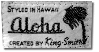
Returning to Honolulu, he was the owner of a Chinatown dry goods shop at 36 North King Street, that he renamed King-Smith Clothiers (the store was named after its location, near the intersection King and Smith Streets.)

With the great depression underway, he looked for ways to increase business; he got the idea to promote a local-style shirt.  Using leftover kimono material, he patterned a shirt after the plantation workers’ palaka shirt (short sleeved, un-tucked square bottom.)  They had a few dozen made and hung them in the window.

He called them “Aloha Shirts.”

“Since there was no pre-printed Hawaiian fabric around, I took patterned Japanese yukata cloth and had a few dozen short-sleeve, square-bottomed shirts made up for me. I put the shirts in the front window of the store with a sign that said Aloha Shirts.’ They were a novelty item at first, but I could see that they had great potential.”  (Chun, 1987 Interview, Star-Bulletin)

They started small, having a few dozen bright printed Hawaiian patterns with hula dancers, palm trees and pineapples.  His store became a mecca for a wide range of customers.

In 1936, Chun registered the “Aloha Shirt” trademark.
“It turned out well.”

That year, two firms, Branfleet (the original company was founded in 1936 as a partnership between the Frenchman George Brangier and a Californian, Nat Norfleet; later known as Kahala Sportswear) and the Kamehameha Garment Company, began to shift the focus of the garment industry to a larger and more export-oriented market.

Their products, factory-made sportswear, provided the direction and product line that continues to dominate large segments of the industry today.  (Chinen)

A shipping strike in 1936 forced the companies to explore the local island market which brought them renewed success. The years 1936-1939 were big growth years for the garment industry in general and each company typically came out with 15 or more new shirt designs each year.

Paradise of the Pacific published its first photograph of a man wearing an aloha shirt in 1938. Soon thereafter, movie stars took up the fad. By 1940, officials of the Territorial and City and County governments were allowing their employees to wear aloha shirts, at least in warm weather.  (Schmitt)

After World War II, a gradual change in aloha wear took place with the breakdown of rigid dress requirements for business attire. The business tie and jacket certainly were not comfortable in Hawaiʻi’s summer climate. In 1946, the Honolulu Chamber of commerce appropriated $1,000 to study aloha shirts and prepare suitable designs for clothing businessmen could wear. (Art of the Aloha Shirt)

In 1947, the Hawaiʻi Chamber of Commerce organized an annual event called Aloha Week, during which office workers were encouraged to shed their suits and wear Alohas to work. In the 1960s, the chamber invented Aloha Fridays, which led to casual Fridays.  (Washington Post)

By 1950, however, “screen printing” had emerged, led by companies like Alfred Shaheen and Von Hamm Textiles. This procedure permitted the printing of smaller yardages, expressly for local designers. More important, it permitted brighter and more shaded prints which, from 1947 on, received greater national and international exposure through yearly Aloha Week publicity events.  (Chinen)

Up to the middle to late-1950s was considered the Golden Age of aloha shirts.  Rayon with smooth finish and Hawaiian prints became the pinnacle of aloha shirts. Complicated eye popping patterns containing all aspects of Hawaiian culture and artifacts were included on the aloha shirts, often referred to as “chop suey” prints because of the mixture of content in the design.  (Art of the Aloha Shirt)

The modern era of aloha shirts is considered the 1960s and beyond. In 1962 the Hawaiian Fashion guild staged “Operation Liberation”, giving two aloha shirts to each man in the State House and Senate. The Senate passed a resolution urging the regular wearing of aloha attire from Lei Day, May 1st, and throughout the summer months.

Aloha Friday officially began in 1966, and by the end of the 1960s, the wearing of aloha shirts for business dress any day of the week was accepted.   (Art of the Aloha Shirt)

According to Alfred Shaheen, “It (Aloha dress) was really provincial in Hawaiʻi then; the old timers were into formality.  They weren’t far from missionaries; in fact, many were descendants of the missionaries so they were still pretty strict and puritanical about things. …  So it was a new breed, the younger guys who were ready for a new style.”  (Art of the Aloha Shirt)

With aloha dress accepted as every-day wear, Reyn Spooner shirts came on the scene in the early-1960s.  Reyn McCullough liked Pat Dorian’s original “reverse” print shirt and started to market it in his Ala Moana Center store.  It was a more conservative, “traditional” pullover reverse shirt with a button-down-collar and tails to tuck into slacks.  (Tim McCullough)

“Aloha attire is a pan-ethnic expression.  What it does is show varied influences coming to Hawai’i. Clothing shows us that all the ethnicities have an impact on what we wear.”  (Arthur, UH)

Ellery Chun eventually closed his store and became a bank vice president.  He died in 2000; that year, Governor Ben Cayetano proclaimed “The Year of the Aloha Shirt.”  (Lots of information here from Aloha Shirts of Hawaiʻi, The Art of the Aloha Shirt and Chinen.)

Chun’s legacy lives on.

© 2023 Hoʻokuleana LLC

Filed Under: Economy, General, Prominent People Tagged With: Hawaii, Reyn McCullough, Ellery Chun, Aloha Shirt

April 18, 2023 by Peter T Young Leave a Comment

What Had Long Been Feared

“What has long been feared by some, and considered a certain event by others, has happened. The Chinese quarter of Honolulu has been devastated by a fire, that, gaining headway in the dense aggregation of wooden buildings, was quickly beyond control and sweeping in all directions.” (Daily Bulletin – April 19, 1886)

It started on April 18, 1886.  A few minutes before 1 o’clock the fire started in a Chinese cook house on the corner of Hotel street and Smith’s lane. It started accidentally by the owner of the premises in lighting his fire for cooking.

“Although not a breath of wind stirred … quicker than can be told the fire was leaping from roof to roof, gliding along verandahs, entwining itself about pillars and posts, festooning doors and windows . … In the calm the smoke rose in a vast volume . . . . Both [Smith and Hotel] were soon lanes of fire.”  (Daily Bulletin – April 19, 1886)

After a seven-hour ordeal-about half of it in darkness-the walls of the last building to collapse fell in. It was exactly 11:20 and the place was the makai side of the King Street bridge leading across to the Palama district.

As the embers cooled, tempers flared.

Hawaiians of Chinatown, especially around the ʻEwa side of Maunakea Street, where they had been the greatest losers, were bitter.  They blamed it all on the Chinese.

By midnight a mob of perhaps 3,000 crowded around the King Street bridge and back to the Chinese theater. As Hawaiians itched for a fight, things could get nasty – fortunately, cooler heads prevailed and while skirmishes occurred, a full-on riot was avoided.

Honolulu’s Chinatown, then and now, is the approximate 36-acres on the ʻEwa side of Downtown Honolulu.  It developed into a Chinese dominated place, following the in-migration of Chinese to work on the sugar plantation, starting in 1852.

Between 1852 and 1876, 3,908 Chinese were imported as contract laborers, compared with only 148 Japanese and 223 South Sea Islanders. Around 1882, the Chinese in Hawaii formed nearly 49% of the total plantation working force, and for a time outnumbered Caucasians in the islands.

It had been noted, according to one observer in 1882, for the fact that the great majority of its business establishments “watchmakers’ and jewelers’ shops, shoe-shops, tailor shops, saddle and harness shops, furniture-shops, cabinet shops and bakeries, (were) all run by Chinamen with Chinese workmen.”

By 1884, the Chinese population in Honolulu reached 5,000, and the number of Chinese doing plantation work declined.   As a group they became very important in business in Hawaii, and 75% of them were concentrated in Chinatown where they built their clubhouses, herb shops, restaurants, temples and retail stores.

By 1886, there were 20,000 people living in the area between Nuʻuanu Stream, Nuʻuanu Avenue, Beretania Street and Honolulu Harbor.

Most of the structures were one- and two-story wooden shacks crammed with people, animal and pests. Chinatown had a poor water supply system and no sewage disposal.

Although the fire intensified anti-Chinese feeling, this group had long been under attack. During the 1880s, spurred by what was considered an alarming influx, the Hawaiian government had limited – and for a time halted – their coming.

The year before the fire, massive Japanese immigration started. It had been conceived and encouraged not only to man plantation fields, but also to provide a counterbalance to the Chinese.

The 1886 blaze destroyed eight blocks of Chinatown. While the government soon after established ordinances to widen the narrow streets and limit building construction to stone or brick, nothing was enforced. More ramshackle buildings went up, laying the groundwork for future disaster and disease.

The 1886 fire started at the corner of Hotel and Smith Streets.

They rebuilt.

In 1900, fire struck again.  However, in 1900, the Board of Health intentionally set “sanitary” fires to prevent further spread of the bubonic plague.  Those got out of control.

The 1900 fire caused the destruction of all premises bounded by Kukui Street, River Street, Queen Street (presently Ala Moana Boulevard) and Nuʻuanu Avenue.

Today, the majority of buildings in Chinatown date from 1901 with very few exceptions which escaped the January 20, 1900 fire.

© 2023 Hoʻokuleana LLC


Filed Under: General, Economy Tagged With: Hawaii, Oahu, Chinatown

April 17, 2023 by Peter T Young Leave a Comment

The Battle of Hōkūʻula

Prominent features rising above the town of Waimea on the Big Island are the puʻu (cinder cones) in the surrounding pasture.  The South Kohala community made special note of these physical features in the Community Development Plan noting, “the Puʻu define the special landscape ‘sense of place’ of Waimea.”

One of these, Hōkūʻula (red star,) played a prominent role in battles between warring leadership from the islands of Maui and Hawaiʻi.  This story dates back to about the mid-1600s.

To put this timeframe in global perspective, around this time: the Ming Dynasty in China ended and the Manchus came into power and established the Qing dynasty; the Taj Mahal was completed in India: British restored the monarchy and Charles II was crowned king of England; and the Massachusetts Bay colony was forming after the recent landing of the Pilgrims at Plymouth Rock.

In the islands, Lonoikamakahiki (Lono) was the Mōʻi (Chief) of Hawai‘i.  He was a descendant of Pili (a high chief from Tahiti from the 13th century.  Lono was grandson of ʻUmi (and great grandson of Līloa.))

“Lono-i-ka-makahiki was a son of Keawe-nui-a-Umi, and was chief of Ka-u and Puna. He was sole ruler over those two districts on Hawaii. He was married to a chiefess, named Ka-iki-lani-kohe-paniʻo, who was descended from Laea-nui-kau-manamana. To them were born sons, Keawe-Hanau-i-ka-walu and Ka-ʻihi-kapu-mahana.”   (Kamakau)

Through marriage and victories over other chiefs, Lonoikamakahiki became the ruler of the Island of Hawaiʻi.  “During Lono’s reign, when he tended to the affairs of his kingdom, the chiefs and commoners lived in peace.”  (Kamakau)

Lono visited the Mōʻi of the various islands, including Kamalālāwalu, ruling chief of Maui.  “Lono-i-ka-makahiki sought the good will of these chiefs when he came to meet and associate with them in a friendly manner. There were to be no wars between one chief and another.”  (Kamakau)

Kamalālāwalu (Kama) met him and welcomed him royally.  The chiefly host and guest spent much time in surfing, a sport that was enjoyed by all.  Lono was lavishly entertained by Kamalālāwalu.

Not long after Lono’s departure and return to Hawai‘i, however, Kamalālāwalu, driven by ambition, decided to invade and conquer the nation of Island of Hawai‘i.  He sent spies to survey the opposition; they reported there were few men in the Kohala region.

When Kamalālāwalu heard the report of his spies, he was eager to stir his warriors to make war on Hawaiʻi.  Most of the prophets and seers supported the chief’s desire and gave dogs as their omen of victory [said that clouds taking the form of dogs foretold victory]. The dogs were a sign of fierceness, and so would the chief fiercely attack the enemy and gain the victory with great slaughter of the foe.

Part of the prophets and seers came to the chief with prophecies denying his victory, and urging him not to go to fight against Hawaiʻi.  When Lanikāula, a high priest from Moloka‘i, warned Kamalālāwalu of the dangers of an assault, an irate Kamalālāwalu replied “when I return, I will burn you alive.” (Fornander)

Kamalālāwalu’s fleet landed in Puakō and met no opposition. Lono’s oldest brother, Kanaloakuaʻana, was in residence Waimea at the time, and, upon hearing of the invasion, marched toward Puakō with what forces he had at hand. A battle ensued at Kauna‘oa (near the present-day Mauna Kea Resort), and Kanaloakuaʻana’s forces were defeated, with Kanaloakuaʻana himself being taken prisoner and eventually killed.

After this initial success, Kamalālāwalu and his Maui warriors marched boldly inland and took up a position above Waimea on top of the puʻu called Hōkūʻula and awaited Lono’s forces.

During the night, Lono’s warriors from Kona arrived and occupied a position near Puʻupā (the large cinder cone makai of the Waimea-Kohala Airport.) His warriors from Kaʻū (led by its high chief and Lono’s half-brother, Pupuakea) and Puna were stationed from the pu‘u called Holoholoku (the large cinder cone out in the plains below Mauna Kea,) those from Hilo and Hāmākua were stationed near Mahiki, and those from Kohala were stationed on the slopes of Momoualoa.

That morning, from his position atop Hōkūʻula, Kamalālāwalu could see that the lowlands were literally covered with the countless warriors of Lono, and realized that he was outnumbered. For three days the armies skirmished, with the actions of the Maui warriors being dominated by Kamalālāwalu’s nephew and chief, Makakuikalani.

“Short and long spears were flung, and death took its toll on both sides. The Maui men who were used to slinging shiny, water-worn stones grabbed up the stones of Puʻoaʻoaka. A cloud of dust rose to the sky and twisted about like smoke, but the lava rocks were light, and few of the Hawaii men were killed by them.”  (Kamakau)

“The warriors of Maui were put to flight, and the retreat to Kawaihae was long. [Yet] there were many who did reach Kawaihae, but because of a lack of canoes, only a few escaped with their lives. Most of the chiefs and warriors from Maui were destroyed.”  (Kamakau)

While Kamakau notes Kamalālāwalu died on the grassy plain of Puakō, other tradition suggests that after Lonoikamakahiki defeated Kamalālāwalu at Hōkūʻula, he brought the vanquished king of Maui to Keʻekū Heiau in Kahaluʻu and offered him as a sacrifice.

The spirits of Kamalālāwalu’s grieving dogs, Kauakahiʻokaʻoka (a white dog) and Kapapako (a black dog,) are said to continue to guard this site.  Outside the entrance to the heiau and towards the southwest are a number of petroglyphs on the pāhoehoe.  One of them is said to represent Kamalālāwalu.

So ended the first of the major wars between the nations of Maui and Hawai‘i, and a turning point in the history of Hawai‘i.

(Puʻu Hōkūʻula is sometimes referred as “”Buster Brown.”  Apparently, while training at Camp Tarawa in Waimea, Marines named it Buster Brown Hill after the former section manager for Parker Ranch, who lived just below the hill.)

© 2023 Hoʻokuleana LLC

Filed Under: Ali'i / Chiefs / Governance, Hawaiian Traditions Tagged With: Umi-a-Liloa, Waimea, Camp Tarawa, Kawaihae, Puako, Hokuula, Kamalalawalu, Kamuela, Hawaii, Lonoikamakahiki, Maui

April 16, 2023 by Peter T Young Leave a Comment

St Peter’s Chapel

“There are a few, very small fishing villages, Alae, Alika and Papa, which are reached by poor trails from the mauka road. It is necessary to travel from Hookena mauka to the main road to Papa, and thence by either road or trail to Hoopuloa, the last steamship landing in Kona.”

“This is another village which is dwindling in population, only a few Hawaiians and a couple of Chinese storekeepers remaining. A fair road leads across a barren a-a flow to Miloli‘i, the largest and best specimen of an exclusively Hawaiian village on the Island, which is seldom visited.”

“It is splendidly situated by a sand beach, the sea coming right up to the yard wall, and is inhabited by a rather large population of Hawaiians, who prosper through the fishing which is almost phenomenally good…”

“This region is seldom visited. Its chief points of interest are the remains of a heiau, mauka of the Catholic church at Milolii, some fine papa konane at the south end of the same village a well preserved kuula (still used) where fishermen offer offerings of fruit to insure a good catch, by the beach south of Milolii, where the Honomalino Ranch fence crosses the trail; while all along the trail are smaller kuulas, and at many points the foundations of villages, where old implements may still be found.” (Kinney, 1913)

“Hoopuloa was one of the few typically Hawaiian villages remaining in Hawaii. It comprised of a cluster of 10 to 15 homes of old Hawaiian style and boasted a population of approximately 100 persons … The wharf was a port of call for the Inter-Island steamers”. (Honolulu Star Bulletin, April 19, 1926)

Then … “The number of earthquakes recorded for April [1926] was 671 (compared with monthly average of 52 for the preceding 3 months. … The maximum daily frequency of earthquakes in the 1926 eruption was on April 15 (86 shock), the first day of free-flowing flank eruption …” (Jaggar)

Edward G Wingate, USGS topographical engineer, was mapping the summit of Mauna Loa in 1926, changing campsites as the work progressed. On April 10 his camp was along the 11,400-foot elevation, well into the desolate upland above the Kau District.

An earthquake wakened the campers about 0145; as they drifted back to sleep, a further series of quakes had them sitting up, talking, and wondering. About 0330 Wingate braved the cold and wind; with a blanket wrapped around him, he went outside and stood bathed in reddish light.  (USGS)

There was a brief summit eruption, followed by 14 days of eruption on the southwest rift zone.  “About 3 am April 10 (1926,) glowing lava spouted along the upper 3 miles of cones and pits of the Mauna Loa rift belt, immediately south of Mokuʻāweoweo, the summit crater.  … The actual beginning shown at Kilauea by seismographic tremor was 1:36 am, followed by two pronounced earthquakes.”    (Jaggar)

For three days the HVO party surveyed the sources of the eruption; then they descended and moved into Kona District, where roads, houses, and other property were threatened by the flows. Wingate and his crew stayed behind. Much of the area already mapped was under fresh lava, and there was a lot of remapping to do.  (USGS)

“A crack only 1 to 3 feet wide opened southward from a point tangent to the ease edge of the bottom of the south pit of Mokuʻāweoweo, vomited out pumiceous silvery pāhoehoe froth lava, and extended itself S.30oW. past the next two pits and over the brow of the mountain down to an elevation of 12,400 feet.”  (Jaggar)

“Fortunately the main gushing of this first phase ceased about 5 am the same forenoon, after flowing 5 hours. … (Then,) The vent crack was splitting itself open downhill. The source pāhoehoe changed itself by stirring into scoriaceous aa half a mile from the vents”. (Jaggar)

“When it got close to the upland of Hoʻopuloa, the flow of lava separated into two, and one of the flows went straight for the village of Hoʻopuloa and the harbor, and the second flow went towards the village of Miloliʻi.”  (Hoku o Hawaii, April 20, 1926)  

“(T)he Honomalino flow to the west finally dominated, … This was also aa. … It crossed the belt road at 12:22 pm April 16, 3 miles above Hoʻopuloa village.” (Jaggar)

On April 16, Jaggar scratched marks about a foot apart across the rutted, gravel road (the only road) between the Kona and Kau Districts. A lava flow was approaching, and Jaggar wanted to measure the flow’s speed as it crossed the road.

St Peter’s Chapel, sometimes referred to as Ho‘opuloa Catholic Church, was on the makai side of the road.  Perhaps a hundred people were waiting around the Hoʻopuloa Church, on the uphill side of the road, and at the Kana‘ana house opposite, on the downhill side of the road.

They had seen and heard the flow, 15-20 feet high and more than 500 feet wide, as it moved through the forest uphill.  When it neared the road, people who lived on the Kona side of the flow moved off to the north, and those who lived on the Ka‘u side moved to the south, so they could go home after the road was closed.  (USGS)

Jaggar recorded that it reached the uphill, inland side of the road at 12:22 at an estimated speed of about 7 feet/minute; within two minutes the road was crossed. Jaggar and his assistant, HS Palmer, stayed on the Ka‘u side.  (USGS)  St Peter’s Chapel, sometimes referred to as Ho‘opuloa Catholic Church, was on the makai side of the road.

“The Catholic church, where many Hawaiians worshipped, was one of the first building to be destroyed in the flow which buried Hoopuloa.”  (The Star, NZ, May 21, 1926)

“It is true that I saw the church destroyed by the lava tide, which moved onward with irrevocable majesty, entering the house of worship by way of the open front door.”

“Through the windows I observed the red mass proceed to the alter as the whole structure, capable of seating 20 worshipers, burst into flames.”

“Most dramatic of all was the moment when the slow moving red-hot deluge, pressed on by the mass of lava from the rear, tipped the church from its foundations and set it careening upon the molten river.”

“Straightaway, the bell, which hung in an open steeple, began ringing. It pealed above the roar of the flames and the grinding of the blazing substance surging onward.”

“A dozen doleful strokes of the iron tongue echoed farewell before it fell from the cross beam ringing its own requiem.”  (Father Eugene Oehman, Honolulu Advertiser, July 31, 1932)

A memorial to the church was erected; the plaque on the monument reads “1926 Hoopuloa Catholic Church.” “Under the cross, 25 feet below the surface is all that remains of a small Catholic church, over which the lava flowed without a moment’s halt.” (Honolulu Advertiser, July 31, 1932)

“The fiery lava engulfed the harbor and village of Hoʻopuloa, and now they are but a heap of pāhoehoe lava.” (Hoku o Hawaii, April 20, 1926)

“Families of Ho‘opuloa were forced out of their homes by the flow, and many eventually settles in Miloli‘i on state land.  The displace families remained on the land although they had no legal title to the property.” (Hawaii Tribune Herald, July 10, 1985)

In 1932, St. Peter’s Catholic Church at Miloli‘i was built by Father Steffen to replace an earlier St. Peterʻs destroyed by the 1926 lava flow. (PaaPonoMilolii)

In 1982, the State Legislature passed Act 62 which designated 52.6 acres of state land to be leased to the refugees and the descendants of the Ho‘opuloa lava flow.”

The Act also created the criteria by which people could qualify fo5 65-year leases”  Initial implementation of the Act took place July 12, 1985 with the signing of 12 long-term leases for families living on the designated property.  (Hawaii Tribune Herald, July 10, 1985)

© 2023 Ho‘okuleana LLC

Filed Under: General, Missionaries / Churches / Religious Buildings Tagged With: St Peter's Chapel, Hoopuloa Catholic Church, 1926, Hawaii, Eruption, Mauna Loa, Hoopuloa, South Kona

April 15, 2023 by Peter T Young Leave a Comment

Wind, Wings and Waves

Hawaiʻi is the world’s most-isolated, populated-place, we are about: 2,500-miles from the US mainland, Samoa & Alaska; 4,000-miles from Tokyo, New Zealand & Guam, and 5,000-miles from Australia, the Philippines & Korea.
 
We are surrounded by a vast ocean and sometimes naively feel isolated, separated and protected from outside threats and negative impacts.  Unfortunately, we take too much for granted.
 
Formation of Hawaiian Island chain started more than 70 million years ago.  Yet despite millions of years of isolation, plants, animals and insects found their way to Hawaiʻi … on Wind, Wings and Waves.
 
Some seeds, spores and insects arrived on the wind.  A few birds flew or were blown off course; in them or stuck to their feathers were more seeds.  Some seeds managed to float here on ocean currents or waves.  Ocean currents also carried larval forms of fish, invertebrates, algae and even our freshwater stream species.
 
It is estimated that one plant or animal arrived and successfully colonized every 30,000 years.  Over millions of years in isolation, these original plant and animal species changed, forming into our native species.
 
The first alien species arrived with Polynesians in the year 300 A.D. or so. In 1778, Hawaiʻi was placed on the world map; and so started new invasive species pathways.
 
It is estimated that in the last 230+ years, as many as 10,000 plants have been introduced: 343 new marine/brackish water species; Hawaiʻi went from 0 native land reptiles to 40; 0 amphibians to 6 (including coqui) and there is a new insect in Hawaiʻi every day.
 
The greatest threat to Hawaiʻi’s native species is invasive species.
 
Hawaiʻi has the dubious distinction of being called the endangered species capital of the world and unfortunately leads the nation in endangered species listings with 354 federally listed threatened or endangered listed species.
 
With only 0.2% of the land area of the United States, nearly 75% of the nation’s historically documented plant and bird extinctions are from Hawaiʻi.  We have more endangered species per square mile on these islands than any other place on Earth.
 
Impacts from invasive species are real and diverse: Tourism and agriculture-based economy; Forests’ ability to channel rainwater into our watersheds; Survival of native species found nowhere else; Health of residents and visitors; and Quality of life that makes Hawaiʻi a special place.
 
Today, the pathways to paradise are diverse, including: air & ship cargo; ship hulls & ballast water; hand-carry/luggage; mail & freight forwarders; forestry activities; horticulture trade; aquaculture; pet trade; botanical gardens and agriculture experiment stations (or simply on you and your clothing.)
 
While I was at DLNR, we formed and I co-chaired the Hawai‘i Invasive Species Council, a multi-jurisdictional agency, established to provide policy level direction, coordination, and planning among state departments, federal agencies, and international and local initiatives.
 
Our focus was primarily on two actions: the control and eradication of harmful invasive species infestations throughout the State; and prevention the introduction of other invasive species that may be potentially harmful.
 
We must continue to be vigilant in stopping new pests from coming in and eradicating those that have already made it to our shores.
 
We share a common goal.  Whether your concern is in having enough water, healthy reefs, diverse forests, a healthy economy or a healthy family, we all want the same thing:  To make and keep Hawaiʻi a great place to live.
 
© 2023 Ho‘okuleana LLC
 

Filed Under: General Tagged With: Invasive Species, Native Species, HISC, Hawaii Invasive Species Council, Hawaii

  • « Previous Page
  • 1
  • …
  • 173
  • 174
  • 175
  • 176
  • 177
  • …
  • 560
  • Next Page »

Images of Old Hawaiʻi

People, places, and events in Hawaiʻi’s past come alive through text and media in “Images of Old Hawaiʻi.” These posts are informal historic summaries presented for personal, non-commercial, and educational purposes.

Info@Hookuleana.com

Connect with Us

  • Email
  • Facebook
  • LinkedIn
  • Twitter
  • YouTube

Recent Posts

  • About 250 Years Ago … ‘Give Me Liberty, Or Give Me Death’
  • About 250 Years Ago … Stamp Act
  • Telling Time
  • Arterials
  • Place Names
  • Hawaiʻi Statehood Address – Aloha ke Akua
  • Eleanora and Fair American

Categories

  • General
  • Ali'i / Chiefs / Governance
  • Buildings
  • Missionaries / Churches / Religious Buildings
  • Hawaiian Traditions
  • Military
  • Place Names
  • Prominent People
  • Schools
  • Sailing, Shipping & Shipwrecks
  • Economy
  • Voyage of the Thaddeus
  • Mayflower Summaries
  • American Revolution

Tags

Albatross Al Capone Ane Keohokalole Archibald Campbell Bernice Pauahi Bishop Charles Reed Bishop Downtown Honolulu Eruption Founder's Day George Patton Great Wall of Kuakini Green Sea Turtle Hawaii Hawaii Island Hermes Hilo Holoikauaua Honolulu Isaac Davis James Robinson Kamae Kamaeokalani Kameeiamoku Kamehameha Schools Lalani Village Lava Flow Lelia Byrd Liberty Ship Liliuokalani Mao Math Mauna Loa Midway Monk Seal Northwestern Hawaiian Islands Oahu Papahanaumokuakea Marine National Monument Pearl Pualani Mossman Quartette Thomas Jaggar Volcano Waikiki Wake Wisdom

Hoʻokuleana LLC

Hoʻokuleana LLC is a Planning and Consulting firm assisting property owners with Land Use Planning efforts, including Environmental Review, Entitlement Process, Permitting, Community Outreach, etc. We are uniquely positioned to assist you in a variety of needs.

Info@Hookuleana.com

Copyright © 2012-2024 Peter T Young, Hoʻokuleana LLC


Loading Comments...