Images of Old Hawaiʻi

  • Home
  • About
  • Categories
    • Ali’i / Chiefs / Governance
    • American Protestant Mission
    • Buildings
    • Collections
    • Economy
    • Missionaries / Churches / Religious Buildings
    • General
    • Hawaiian Traditions
    • Other Summaries
    • Mayflower Summaries
    • Mayflower Full Summaries
    • Military
    • Place Names
    • Prominent People
    • Schools
    • Sailing, Shipping & Shipwrecks
    • Voyage of the Thaddeus
  • Collections
  • Contact
  • Follow

December 16, 2022 by Peter T Young Leave a Comment

Ka Wailele ʻO Waiānuenue

The Wailuku is the longest river in Hilo (twenty-six miles.) Its course runs from the mountains to the ocean along the divide between Mauna Kea and Mauna Loa. The Wailuku is the boundary between Hilo Palikū in the north and Hilo One on the south.

The earliest recorded bridge in Hawai‘i was a crude footbridge across the Wailuku River in Hilo and was reported by missionary C. S. Stewart in 1825. (The first major bridge on O‘ahu appears to have been one extending North Beretania Street across Nuʻuanu Stream, erected in 1840.) (ksbe)

“About a hundred yards above the beach, it (the stream) opens into a still deep basin, encircled by high cliffs. Into this basin the whole stream is projected by two cascades … A rude bridge crosses the stream just above the falls; and it is a favorite amusement of the natives to plunge from it, or from the adjoining rocks, into the rapids, and pass head foremost over both falls, into the lower basin.” (Stewart, Schmitt)

The Wailuku River bridge must have existed for only a short time, and it was quickly forgotten. Sereno Bishop, born on the Big Island in 1827, later recalled, “There were no bridges in these islands until after 1840.” Titus Coan, the pioneer missionary who settled in Hilo in 1835, wrote, “For many years after our arrival there were no roads, no bridges, and no horses in Hilo”. (Schmitt)

Hilo’s Wailuku River was finally spanned again in September 1859, this time by a 196-foot-long suspension bridge. Less than seven weeks after it was opened, this bridge collapsed while a party of eight or ten persons and their horses were attempting to cross. The group narrowly averted drowning and death by falling timbers.

This was not the first disaster or near-disaster at the site of the Wailuku Bridge. Weakened by earthquakes and a tsunami, the railroad bridge over the Wailuku River collapsed on March 31, 1923 – immediately after a loaded passenger train had crossed and another was approaching.

Two of the largest bridges on the Hawai‘i Consolidated Railway were destroyed by the 1946 tsunami, a disaster which effectively put that railroad out of business. (ksbe)

Waiānuenue Avenue (rainbow (seen in) water) in Hilo town is named for the most famous waterfall in Hilo, Ka Wailele ʻO Waiānuenue, Rainbow Falls. There is a legend about this falls, the goddess Hina, her son Māui and the lizard-man Kuna.

Hina once lived in the cave beneath and behind the waterfall. Kuna would throw logs and boulders over the edge of the falls to try to cause harm to Hina. She called to her son Māui and he came quickly to her aid. He chased Kuna upland along the river, where they engaged in many battles.

Finally, Māui emerged the victor, though only because he was aided by the volcano goddess Pele. Hina was now safe. Many places along the Wailuku were named to commemorate different parts of the story so that the legend would not be forgotten. (Zane)

The local utility Hawaii Electric Light Co (HELCO) owns and operates two hydroelectric facilities arranged in tandem along the lower reach of the Wailuku River near Hilo. The Waiau plant was constructed in 1920 and upgraded in 1947. The Puʻueo plant downstream was built in 1910 and upgraded in 1941. The Wailuku River Hydroelectric Power Company plant began commercial operation in 1993. It is located at the junction of the Wailuku River and the Kaloheahewa Stream.

A 6-foot-diameter intake pipe for HELCO is located about 100 feet above Ka Wailele ʻO Waiānuenue. The intake feeds the utility’s Puʻueo Hydroelectric Plant located down on Wainaku Street, several blocks from the ocean.

About a mile upstream is a section of river called Boiling Pots, as well as the Peʻepeʻe Falls.

© 2022 Hoʻokuleana LLC

Filed Under: Place Names Tagged With: Hawaii, Hilo, Wailuku River, Rainbow Falls

December 14, 2022 by Peter T Young Leave a Comment

David Kamehameha

Mataio Kekūanāoʻa (1793–1868) and Kīnaʻu (1805-1839) each served as Kuhina Nui, a position generally described as “Prime Minister,” “Premier” and “Regent.”  They were each born of chiefs; Kekūanāoʻa was son of an Oʻahu chief; Kīnaʻu was the daughter of Kamehameha I.

They were also husband and wife.

They had five children: four boys, David Kamehameha (1828–1835), Moses Kekūāiwa (1829-1848,) Lot Kapuāiwa (1830–1872,) Alexander Liholiho (1834–1863,) and a girl, Victoria Kamāmalu (1838–1866.)

Consistent with custom, each of the sons were hānai (adopted) to other families – David by Kaʻahumanu, Moses by Kaikioʻewa, Lot by Nahiʻenaʻena, and Alexander by Kauikeaouli.  (Luomala)

When Kīna‘u’s last child, Victoria Kamāmalu, was born she refused her maternal uncle Kuakini’s request to take the child to the island of Hawaiʻi to rear. Defying custom, she herself nursed her and her adopted daughter Pauahi (but made John Papa ʻĪ‘ī and his wife Sarai her child’s kahu.)  (Luomala)

We hear a lot about two of Kekūanāo’a and Kīnaʻu’s sons – Alexander Liholiho became Kamehameha IV and Lot Kapuāiwa became Kamehameha V (daughter Victoria Kamāmalu became Kuhina Nui, like her parents.)

We do not often hear about David Kamehameha.

Some suggest David’s birth had helped reconcile differences between Ka‘ahumanu and Kīnaʻu.

It was the wish of Kamehameha the Great that Kīnaʻu and Kamāmalu, his daughters by Kaheiheimalie, marry his sons by Keōpūolani, the highest ranking chief of the ruling family in the kingdom during her lifetime, to continue his line.

Kamāmalu became the wife of Liholiho (Kamehameha II.)  Kīnaʻu had refused to marry Kauikeaouli (Kamehameha III.)  (Luomala)

When Kīnaʻu and Kekūanāoʻa were married, Kaʻahumanu was furious; “she ground her teeth and spit fire. … It was not until Kīnaʻu became pregnant with her first child that Kaʻahumanu became reconciled to what had taken place.” (Kamakau)

As was the custom, the child was hānai (adopted) by others.  Pukui, emphasizing the permanency of the hānai relationship, has stated that a child “is the hānai of his permanent, adoptive parents” and the relationship is as permanent as that in modern legal adoption.  (Luomala)

At his birth (May 20, 1828,) Kīnaʻu presented her first-born, Prince David Kamehameha, to Kaʻahumanu, “a boy fine enough for any mother not of the seed royal to glory in.”  (Judd)

A second grandchild whom Kaʻahumanu had charge of at this time was Princess Ruth Keʻelikōlani. (Kamakau)

Kaʻahumanu clashed with Boki (Governor of Oʻahu.)

“He (Boki) accused Kaʻahumanu of appropriating to herself the private estate of the young king (Kauikeaouli – Kamehameha III) so that he could have no land, and of reviling him by calling him a servant of David Kamehameha and of Ruth, the daughter of Kekūanāoʻa and Pauahi, who had been one of the wives of Liholiho. But these slanders recoiled on the governor, whose folly and wickedness contrasted strongly with the prudence and inoffensiveness of the queen regent.”  (Bingham)

When Kaʻahumanu received word that Boki may try to kill her, Kaʻahumanu said, “I do not fear death planned by this son of ours, but he will have to (come) himself to kill me and these grandchildren of mine who will stay by me.” (These were David Kamehameha and Ruth Keʻelikōlani.)  (Boki later gave up the idea of killing Kaʻahumanu.) (Kamakau)

When David was four, in 1832, Kaʻahumanu died at her house in Mānoa Valley, and afterwards, David was raised by Kekāuluohi (Kīnaʻu’s half sister, who became Kuhina Nui of Hawaiʻi on April, 5, 1839 and took the name Kaʻahumanu III.)

Hiram Bingham noted David Kamehameha was “the favorite little son of Kekāuluohi;” although it is likely Kīnaʻu still had a hand in his upbringing.

Kekāuluohi joined Kawaiahaʻo Church on March 2, 1828 the third occasion in the history of the church on which members were received into it, and Kīnaʻu on March 7, 1830. These chiefesses were of the same firmness of character as Kaʻahumanu, and their husbands took a similar stand. They too were like parents to the people.  (Kamakau)

Prince David Kamehameha died of unknown causes at the age of seven, December 15, 1835.  He was buried at Pohukaina on what is now the ʻIolani Palace grounds and was later transported and buried at the Mauna ʻAla Royal Mausoleum.

On November 16, 1836, High Chief Kahana Kapaʻahea and the High Chiefess Analeʻa Keohokālole had their third son, David Kalākaua; it has been suggested that he was named in honor of David Kamehameha.

© 2022 Hoʻokuleana LLC

Filed Under: Ali'i / Chiefs / Governance Tagged With: Moses Kekuaiwa, Hawaii, Kalakaua, Victoria Kamamalu, Lot Kapuaiwa, Alexander Liholiho, Kaahumanu, Mataio Kekuanaoa, David Kamehameha, Kinau, Kekauluohi

December 13, 2022 by Peter T Young Leave a Comment

Hawaii Geologic Setting

Tiny dots upon a map of the Pacific, the Hawaiian Islands are in reality the tops of a range of mighty mountains, perhaps the greatest mountain range on earth, built up from the sea floor by thousands upon thousands of volcanic eruptions. The average depth of the floor of the ocean on the two sides of the island chain is about 15,000 feet.

Thus the lowest of the islands are mountains more than 15,000 feet high; and Mauna Kea, on the island of Hawaii, rises some 30,000 feet above its base. It is certainly the highest island peak in the world, and quite probably is the world’s highest mountain in terms of elevation above the ocean floor.

Fifteen hundred miles across the central Pacific stretches the line of islands that we call the Hawaiian Archipelago. From Ocean (Kure) Island at the northwest, we pass southeastward by Midway and Gardner Islands, French Frigates Shoal, Necker, Nihoa, and Kaula Islands, all of which are small low islands, until at Niihau we reach the first of the large islands of the Hawaiian group.

There are eight of these major islands. In order southeastward they are: Niihau, Kauai, Oahu, Molokai, Lanai, Kahoolawe, Maui, and Hawaii. Most of the larger islands are well watered and clothed in tropical vegetation—green jewels set in a hand of sparkling white surf, and laid in the blue plush of the ocean.

The small islands northwest of Niihau—the so-called Leeward Islands—are too small to collect a toll of moisture from the passing winds. They are barren and waterless. Lanai and Kahoolawe also are dry, because the high islands to windward of them extract the water from the wind before it reaches them.

The Hawaiian mountains were born when a fissure opened in a northwest-southeast direction across the floor of the Pacific Ocean. How long ago this happened we have no way of knowing.

We believe the oldest rocks of the major islands now visible above sea level may date from the late Tertiary period of geologic time, some 30 or 40 million years ago. Obviously the oldest rocks, at the base of the heap on the ocean floor, must be very much older, perhaps 60 million years old, or even more.

Through most of the period of the islands’ growth upward through the ocean water the building force of volcanism met little opposition.

But as the top of the mountain reached into shallower water near the surface of the sea first currents and then waves began to attack the growing mass, knocking fragments of lava rock loose and washing them away into deeper water.  When eventually the volcanoes thrust their heads above the sea their struggle for existence became still more intense.

Then began the great battle between the constructive forces of volcanism, ever striving to build the island upward and outward with flow upon flow of new lava, and the destructive forces of wave, stream, wind, and even ice erosion, carving away the land and carting away the debris to dump it into the ever-hungry abysses of the ocean.

So long as volcanism continued fully active the islands continued to grow, but when volcanic activity weakened and finally died out the powers of erosion seized control. Great canyons were carved into the slopes by streams, waves battered away at the shores, cutting them back into high cliffs with broad shallowly submerged platforms at their bases, and the whole land mass was gradually worn away.

The ultimate end of this process is a broad, nearly flat platform cutting across the volcanic cone a few tens of fathoms below sea level. All that is left of the former islands is a shoal.

Before this final stage of erosion is reached, however, a new agent of construction appears. On the shallowly submerged platforms, organisms such as corals start to grow in abundance, and secrete their limy skeletons to form reefs. In early stages these reefs surround a central volcanic island, and are known as fringing reefs.

In later stages the volcanic island may disappear entirely leaving only a limestone reef, slightly submerged to form a shoal, or projecting slightly above the water to form an island. Such “coral” islands are ring-shaped and are known as atolls.

Volcanism appears to have progressed southeastward along the great fissure in the ocean floor. At least, the volcanoes at the northwestern end of the Hawaiian chain ceased activity long before those at the southeastern end.

The northwesternmost volcanic mountains have been eroded away until no more volcanic rock can be seen. The visible parts of Ocean (Kure) and Midway Islands are formed entirely of organic limestone and calcareous sand, the remains of lime-secreting sea animals and plants.

We feel quite certain, however, that at some comparatively small depth the limestone rests on the truncated summits of great volcanic mountains.

At French Frigates Shoal, La Perouse Rock is a tiny remaining pinnacle of volcanic rock projecting through the limy reefs. Necker and Nihoa Islands are remains of once much larger volcanic islands, and Niihau has lost a great slice of its eastern slope through marine erosion.

Kauai and Oahu Islands were deeply eroded by streams and waves before a renewal of volcanic activity buried much of their lowlands beneath floods of late lavas. On Maui, the volcanic mountain comprising the western part of the island has been deeply dissected by streams, with the formation of huge valleys such as Iao.

Haleakala Volcano, forming the eastern part of Maui, also had great valleys cut into it by stream erosion before renewed volcanism partly buried the work of the streams.

Hawaii is the southernmost and largest of the islands and also the youngest. Of the five great volcanoes  that built this largest of deep-sea islands, Kohala Volcano at the northern end of the island is the oldest.

Streams have cut huge spectacular canyons into its rainy northeastern slope, and waves driven by the nearly constant trade winds have cut high cliffs along its northeastern shore.

Next to the south, Mauna Kea has not been active since the arrival of the Hawaiian people, but has erupted since its summit was covered by a small glacier during the last great period of glaciation, perhaps within the last 15,000 years.

Hualalai, on the western part of the island, has erupted once in historic time, in 1801. The two southernmost volcanoes, Mauna Loa and Kilauea, are still in their full vigor of activity and for the most part are almost unmarred by erosion.  (All here is copied from Hawaii Nature Notes, Hawaii National Park, May 1951)

© 2022 Ho‘okuleana LLC

Filed Under: General Tagged With: Hawaii, Geology

December 12, 2022 by Peter T Young Leave a Comment

Kalauao

At the time of Cook’s arrival (1778,) the Hawaiian Islands were divided into four kingdoms: (1) the island of Hawaiʻi under the rule of Kalaniʻōpuʻu, who also had possession of the Hāna district of east Maui; (2) Maui (except the Hāna district,) Molokaʻi, Lānaʻi and Kahoʻolawe, ruled by Kahekili; (3) Oʻahu, under the rule of Kahahana; and at (4) Kauaʻi and Niʻihau, Kamakahelei was ruler.

“At that time Kahekili was plotting for the downfall of Kahahana and the seizure of Oahu and Molokai, and the queen of Kauai was disposed to assist him in these enterprises.”  (Kalākaua)  Kamakahelei was married to Kāʻeokūlani (Kāʻeo – younger brother of Kahekili.)  Kamakahelei and Kāʻeo had a son Kaumualiʻi (born in 1778 at Holoholokū.)

Kahekili and his eldest son and heir-apparent, Kalanikūpule, conquered Kahahana, adding Oʻahu under his control.  And, in the late-1780s into 1790, Kamehameha conquered the Island of Hawai‘i and was pursuing conquest of Maui and eventually sought to conquer the rest of the archipelago.

The rich resources of the region, the shoreline fishponds, the numerous springs, and the fertile lands along the streams made ‘Ewa a prize for competing chiefs. Battles were fought for and on ‘Ewa lands, sometimes from competing O‘ahu chiefs, and sometimes by invading chiefs from other islands.  (Cultural Surveys)

At the death of Kahekili in 1793, Kāʻeo became ruling chief of Maui, Molokaʻi and Lānaʻi.  Kalanikūpule was ruler of Oʻahu.  Homesick for his friends, Kāʻeo set out to return to Kauaʻi by way of Waialua and then to Waimea.  He learned of a conspiracy to kill him and by November, 1794, Kāʻeo and Kalanikūpule were ready to fight.  (Kamakau)

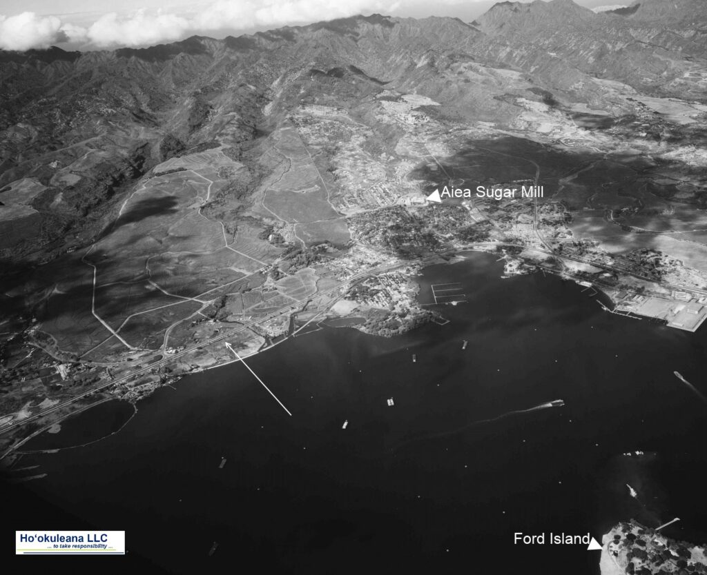
Kāʻeo was successful after some initial skirmishes.  On December 12, 1794, a great battle was fought in the area between Kalauao and ‘Aiea in ‘Ewa.  Kalanikūpule’s forces surrounded Kāʻeo.  (Cultural Surveys)

Kāʻeo with six of his men escaped into a ravine below ‘Aiea and might have disappeared there had not the red of his feather cloak been seen from the boats at sea and there shots drawn the attention of those on land. Hemmed in from above, he was killed fighting bravely.  (Kamakau)

This war, called Kukiʻiahu, was fought from November 16 to December 12, 1794 at Kalauao in ‘Ewa.  (Kamakau)  (It wasn’t long after that Kalanikūpule battled Kamehameha, again; and lost to Kamehameha at the Battle of Nuʻuanu.)

Kalauao Ahupua‘a (the multitude of clouds) extends from the East Loch of Pearl Harbor to the crest of the Koʻolau Range, generally following Kalauao Stream. Kalauao Spring is located near the Pearl Harbor coast.

The Kalauao Spring included two natural springs of percolating water.  In ancient times, the springs irrigated taro loʻi.  Later, the ancient taro lo‘i and ʻauwai (irrigation ditches) were modified and expanded to support rice cultivation.

In 1904, the area was described as, “On the morning of June 2nd, for instance, our destination was Aiea. At ten minutes past seven we boarded the first passenger train going towards Honolulu.”

“For a distance of eight miles the road skirts the shore and then turns landwards or mauka through rice and sugar plantations, Ewa Mill, Waipahu, Pearl City. …”

“Like all rice fields in Hawaii, this one is worked entirely by Chinamen, they alone being able to endure the conditions of location and climate necessary for the cultivation of this cereal.”

“On one side of the railroad track was the broad, muddy inland lake or bay of salt water, Pearl Harbor; on the other side were the terraced plots or fields, flooded to a depth of several inches with water and separated by narrow raised earthen ridges on which the careful Chinaman doubtless succeeded in walking, but which many times proved treacherous to our unsteady feet.”

“A rice plantation, laid out as it generally is on the low flats at the foot of a valley, where mountain streams empty into the sea, is an ideal collecting ground for certain kinds of algae.”  (Thrum 1904)

In 1928, Moriichi and Makiyo Sumida began farming assorted wetland produce on a two-acre plot of land at the springs.  Back then, the area of the springs contained many small farms growing similar produce — bananas, taro, rice, and watercress. Through the ensuing years, the Sumida property grew as they acquired neighboring leases and, by 1950, watercress became the sole crop.  (NPS)

A small waterfall along Kalauao Stream, named Kahuawai (or Kahuewai), was located along the coastal trail connecting Honolulu to Waiʻanae.  Kahuawai (water gourd container) was indicated to have been “a favorite resting place exclusively for chiefs”.  (Cultural Surveys)

Kahuawai was a noted bathing place since ancient times and was guarded so that any one did not bathe in it except the chiefs. Later it was used by all. Kākuhihewa’s daughters and the hero Kalelealuaka (their husband) bathed in this pool. Kāʻeokūlani, the chief of Kauaʻi also bathed here when he came to war here on Oʻahu.  (Cultural Surveys)

Loko Opu, a large fishpond (approximately 10.5-acres in size) located in Kalauao along the Pearl Harbor coast, is said to have been built by the chiefess Kalamanuʻia.  (Cultural Surveys)

During the Māhele, much of the lands in the ahupua‘a of ‘Ewa, as in other districts, were awarded to Ali‘i Nui (high chiefs), who were either the grandchildren or great-grandchildren of Kamehameha I.

Half of the ahupua‘a of Kalauao was awarded to Laura Konia (either granddaughter or grandniece of Kamehameha I;) the other half of Kalauao Ahupua‘a was awarded to John Meek, an important merchant in the sandalwood trade.

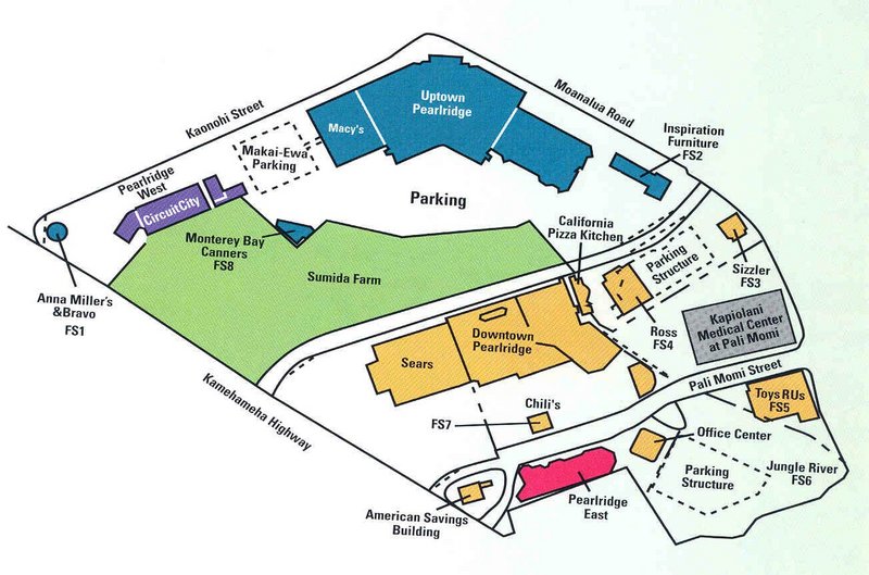
Today, the Pearl Country Club covers much of the lower section of Kalauao.   Pearlridge Shopping Center is on the lowest side of Kalauao (Pearlridge Uptown was opened in 1972, with an expansion in 1976 to include Pearlridge Downtown.)  Pearlridge surrounds the evidence of the water resources of old, Kalauao Spring that benefits the Sumida watercress farm.

© 2022 Hoʻokuleana LLC

Filed Under: Place Names Tagged With: Pearlridge, Hawaii, Oahu, Kalanikupule, Ahupuaa, Kaeo, Ewa, Sumida Watercress, Kalauao

December 11, 2022 by Peter T Young Leave a Comment

Hero of a Hundred Passages

“Resolved, That, in consideration of the long and meritorious services of Capt John Paty, as a ship master out of Honolulu, and the valuable assistance rendered by him in the furtherance of commercial intercourse between the Hawaiian Islands and adjacent ports in foreign countries, as evidenced by the accomplishment of his one hundredth passage across the Pacific,”

“We, American residents and others, in Honolulu, in meeting assembled deem him entitled to be hailed as the Commodore of the Merchant Marine, at the Sandwich Islands, and as such to fly some ensign, emblematical of the rank thus bestowed upon him … on his arrival from San Francisco, and that on its presentation, he shall be saluted with the customary salute of 13 guns.”  (The Friend, November 1, 1860)

“Capt. Paty is a native of good old Plymouth, Mass., and for aught we know, the blood of the master of the May Flower runs in his veins.  (He) is one of those Cape Cod boys, of whom it has been eloquently said, ‘They leap from the cradle to the shrouds without holding on to their mother’s apron strings.’”  (The Friend, November 1, 1860)

They presented him with a commodore’s broad pennant of blue silk, with the figure 100, encircled by ten white stars representing the ten Hawaiian Islands, and with a chronometer; tokens of the community’s appreciation of his years of reliable service.  (Hackler)

Let’s look back.

John Paty was born February 22, 1807 in Plymouth, Massachusetts. His father was a seaman and his mother came of a seafaring family; his father died when John as 7 and his mother, when he was 11.

His first sea-voyage was made in 1821 (at the age of 15,) in the Brig Gov. Winslow, from Boston to Amsterdam with his uncle, Captain Ephraim Paty.  He quickly learned the rigors of life aboard ship, for his relative showed him no favors.

Looking back on his early days at sea, “But when I got on board ship with a hard old shell-back, I found the contrast very great, and my feelings were such, at times, as to induce me to commit almost any deed of violence for the sake of revenge. At other times I wished that I had never been born.”  (Paty; Day)

“His earlier voyages were to the Mediterranean and West Indies, and, it is said, young as he then was, the owners for whom he sailed reposed so much Confidence in his integrity, good judgment, and nautical skill, that they were in the habit of giving him no instructions other than the general and verbal one, to act according to his own discretion.”  (Daily Alta California, February 3, 1869)

He was married in the year 1831 (to his childhood sweetheart, Mary Ann Jefferson of Salem, Massachusetts;) they made their home in Plymouth.  Two years later John’s younger brother Henry returned from the Sandwich Islands. He persuaded John to buy a part interest in the brig Avon and sail in it to Hawai’i.

In 1834, John and Mary Ann sailed for the Sandwich Islands, in the brig Avon, of which he was master and part owner, accompanied by his wife and brother, and arrived at Honolulu in June of that year.  (They had three children while in Hawaiʻi, John Henry Paty (1840,) Mary Francesca Paty (1844) and Emma Theodora Paty (1850.)

He took various voyages back and forth to the continent; on one, he landed in San Francisco in December, 1837 (it was part of Mexico at the time.)  The only buildings in San Francisco were an unfinished adobe belonging to Capt. Wm. Richardson (an Englishman,) and a board shanty near it owned by Jacob P. Leese (an American.)  These two were the only foreign residents there.  (Day; Hesperian)

“Since that time, with the exception of one or two voyages to Atlantic ports previous to 1839, he had been constantly employed in the Pacific, and, principally, between the Hawaiian Islands and parts of Mexico and California.”  (Daily Alta California, February 3, 1869)

In 1857 King Kamehameha IV asked Paty to take the Manuokawai on a voyage of exploration, in the course of which he took possession of Laysan, Necker, Gardener’s Islands and Lysiansky Islands for the Hawaiian Kingdom.  He also corrected old charts, “… a considerable portion of my time has been consumed by calms and looking for banks and islands which do not exist, or are erroneously marked ….”  (Paty; Hackler)

After 168 crossings, in command of the Don Quixote, the Frances Palmer, the Yankee, the Speedwell, the Young Hector, and the Comet, Paty could assert with pride that he never lost a passenger or a seaman, never lost a ship, and never had a serious accident at sea.  (Hackler)

“Old salt,” Capt. John Paty, so long and favorably known throughout the Pacific as one of the most obliging and successful shipmasters that ever commanded a vessel … He has been employed in almost every kind of sea service, in nearly every part of the world, and has universally given most unqualified satisfaction.”  (Polynesian, October 13, 1860)

“Those sailing with him always considered themselves fortunate and secure; and his quiet, amiable disposition, unalloyed good-nature, and uniform courtesy and kindness of manner, made it a pleasure to be a passenger and guest on board the vessel where he was master and host.”  (Daily Alta California, February 3, 1869)

Paty had his home, ‘Buena Vista,’ in Nuʻuanu (on the east side of Nuʻuanu Avenue at Wyllie Street).  (That site is now covered by the Nuʻuanu-Pali Highway interchange.)

John Paty continued to ply the Pacific until four months before his death from cancer, on November 11, 1868.

© 2022 Hoʻokuleana LLC

Filed Under: Economy, Prominent People Tagged With: Hawaii, Kamehameha IV, John Paty, Buena Vista, Nuuanu

  • « Previous Page
  • 1
  • …
  • 161
  • 162
  • 163
  • 164
  • 165
  • …
  • 562
  • Next Page »

Images of Old Hawaiʻi

People, places, and events in Hawaiʻi’s past come alive through text and media in “Images of Old Hawaiʻi.” These posts are informal historic summaries presented for personal, non-commercial, and educational purposes.

Info@Hookuleana.com

Connect with Us

  • Email
  • Facebook
  • LinkedIn
  • Twitter
  • YouTube

Recent Posts

  • Carriage to Horseless Carriage
  • Fire
  • Ka‘anapali Out Station
  • Lusitana Society
  • “Ownership”
  • ‘Holy Moses’
  • Mikimiki

Categories

  • Mayflower Summaries
  • American Revolution
  • General
  • Ali'i / Chiefs / Governance
  • Buildings
  • Missionaries / Churches / Religious Buildings
  • Hawaiian Traditions
  • Military
  • Place Names
  • Prominent People
  • Schools
  • Sailing, Shipping & Shipwrecks
  • Economy
  • Voyage of the Thaddeus

Tags

Albatross Al Capone Ane Keohokalole Archibald Campbell Bernice Pauahi Bishop Charles Reed Bishop Downtown Honolulu Eruption Founder's Day George Patton Great Wall of Kuakini Green Sea Turtle Hawaii Hawaii Island Hermes Hilo Holoikauaua Honolulu Isaac Davis James Robinson Kamae Kamaeokalani Kamanawa Kameeiamoku Kamehameha Schools Lalani Village Lava Flow Lelia Byrd Liliuokalani Mao Math Mauna Loa Midway Monk Seal Northwestern Hawaiian Islands Oahu Papahanaumokuakea Marine National Monument Pearl Pualani Mossman Queen Liliuokalani Thomas Jaggar Volcano Waikiki Wake Wisdom

Hoʻokuleana LLC

Hoʻokuleana LLC is a Planning and Consulting firm assisting property owners with Land Use Planning efforts, including Environmental Review, Entitlement Process, Permitting, Community Outreach, etc. We are uniquely positioned to assist you in a variety of needs.

Info@Hookuleana.com

Copyright © 2012-2024 Peter T Young, Hoʻokuleana LLC


Loading Comments...