Images of Old Hawaiʻi

  • Home
  • About
  • Categories
    • Ali’i / Chiefs / Governance
    • American Protestant Mission
    • Buildings
    • Collections
    • Economy
    • Missionaries / Churches / Religious Buildings
    • General
    • Hawaiian Traditions
    • Other Summaries
    • Mayflower Summaries
    • Mayflower Full Summaries
    • Military
    • Place Names
    • Prominent People
    • Schools
    • Sailing, Shipping & Shipwrecks
    • Voyage of the Thaddeus
  • Collections
  • Contact
  • Follow

November 26, 2021 by Peter T Young Leave a Comment

Haleakalā

On the morning of November 26, 1778, Captain James Cook awoke to the sight of the northern coast of Maui. “Next morning there lay the land, the island of Maui, with its ‘elevated saddle hill’ – the extinct 10,000 foot volcano Haleakala …”

“… rising to its summit above the clouds, and descending gently towards the deep ravines and falling waters of that steep rocky coast, where the trade wind hurled other waters into perpetual surf.” This was the first documented sighting of the island. (Fredericksen)

Haleakalā was thought to have been known to the ancient Hawaiians by any one of five names: “Haleakalā,” “Haleokalā,” “Heleakalā,” “Aheleakalā” and “Halekalā.” (Hawaiʻi National Park Superintendent Monthly Report, December 1939)

Historian Abraham Fornander wrote that “Haleakalā” was a misnomer and that the ancient name for the crater was “Aheleakalā,” which meant “rays of the sun,” and…th[o]se which the demigod Māui snared and broke off to retard the sun in its daily course so that his mother might be able to dry her kapas. Fornander further noted that Lemuel KN Papa, Jr., insisted that the correct name was Alehelā “on account of Māui’s snaring the rays of the sun.” (Fredericksen)

“Of course Haleakalā is the sacred home of our Sun, and the ancient Path to Calling the Sum as depicted in its ancient name: Ala Hea Ka La. Why is this critical to our survival?”

“The Sun’s energy is the source of all life, and governs our most basic rhythm of day and night. Ancient cultures have venerated its being, and we as a human race follow its course without thought and are insignificant in respect of its power.”

“However, our Native Hawaiian Culture praises its existence, until this very day the sun is praised for its cycle.” (Maxwell, Fredericksen)

Haleakalā is best known in stories related of the demi-god Māui; he is best known for his tricks and supernatural powers. In Hawaiʻi, he is best known for snaring the sun, lifting the sky, discovering the secrets of fire, fishing up the islands and so forth. (Fredericksen)

In addition to Māui, Haleakalā stories recall Pele who fled the Big Island and while in exile, Pele stopped for a brief time on Maui, where she dug a pit with her pāoa (divining rod) and started a fire. Haleakala is such a huge pit that she found it difficult to keep the fire going to keep warm.

Sometime later the two sisters (Pele and Namakaeha) engaged in a fierce battle, and Pele was weakened – her body torn to pieces and scattered along the coast into huge mounds of broken lava at the base of Haleakalā, on the east side, near Hāna. This place is now known as “Na Iwi o Pele”—the bones of Pele. (Fornander)

Another deity connected with Haleakala is Poliʻahu—the snow goddess and another rival of Pele. Her younger sister is Lilinoe – goddess of the mists. She is sometimes referred to as the goddess of Haleakalā. She was able to check the eruptions that could break forth in old cinder cones on the floor of the crater. Her presence is noted in heavy mists that shroud the mountain. (Fredericksen)

The slopes of Haleakalā had originally been covered with forests but had been logged out for sandalwood for the China Trade (1788–1838), then for koa, ʻōhia and other indigenous trees for uses ranging from railroad ties to firewood.

The lands were then utilized to grow sugar cane and vegetable crops, or were left as pastureland and served as the locations of a number of small plantation or ranch settlements. (NPS)

“Platforms related to traditional Hawaiian ceremony [were] predominantly found along the crater floor and at high promontory locations. Caves [were] often found on the crater rim.”

“Temporary shelters built against rock outcrops or boulders [were] found scattered along the crater rim and within the crater, but [were] concentrated on the leeward sides of cinder cones such as Pakaoa‘o. Cairns or ahu [were] scattered over Haleakalā.” (Hammatt, NPS)

The first visit to Haleakalā by non-Hawaiians occurred in August 1828 when missionaries Lorrin Andrews and Jonathan Green, along with Dr. Gerrit P. Judd, physician, visited the crater.

They were followed by a US Navy expedition led by Commander Charles Wilkes in 1841, and later, others. Significant public interest was generated by written accounts of these visits that determined that Haleakalā would eventually become a destination for tourism. (NPS)

Homesteading on the slopes of Haleakalā as well as other public lands in Hawai`i had been encouraged by the Territorial Government in 1910. This prompted a “rush for homesteads,” applications which were filed and adjudicated by a land court in Honolulu, including one petition by an unidentified applicant who attempted to acquire the entire “floor of Haleakalā Crater” (Maui News, 8 August 1910) (NPS)

The largest tracts were held by ranches, among them: Grove Ranch (Kaonoulu Ranch), owned by the Baldwins and later sold to Senator Harold W. Rice; Kaupo Ranch, owned by Dwight Baldwin; Ulupalakua Ranch, owned by J.I. Dowsett and then J.H. Raymond, then was purchased by the Baldwins; and Haleakalā Ranch, owned by Harry A. and Frank F. Baldwin and managed by S.A. Baldwin. (NPS)

Until 1935, the primary means of getting to Haleakalā was on horseback, and this continued to be the case for the first three decades of the twentieth century. As late as 1932, the Inter-Island Steamship Company and the Maui Chamber arranged trips on horseback to Haleakalā Crater. (NPS)

Thomas Vint described the trip by horseback that he made in 1930: “The trip is now made from the town of Wailuk[u] which contains the principle hotel on the island of Maui that caters to tourist travel …The combined auto and horse back trip to the 10,000-foot summit may be made from noon to noon from Wailuku, spending the night at the top.”

“Trips into the crater are made from the rim rest house as a base.” Vint concluded that “another rest house at the far end of the crater is needed. To see the crater properly, one should camp overnight, making a two-day trip from the present rest house.” (NPS)

Haleakalā Road (now known as Haleakalā Highway) was finally completed on November 29, 1935, and the number of visitors increased substantially, reaching 16,300 within a year. In 1938, the numbers decreased slightly to 14,156 because of a maritime and shipping strike, but continued to rise in the following years until reaching 29,935 in 1940. (NPS)

The increase in visitors was “greatly in excess of expectations…compared with the few hundreds who visited the crater before construction of the Haleakalā [R]oad (Hawaii National Park Superintendent Annual Report 1935, NPS)

The Civilian Conservation Corps (CCC) began in 1937, succeeding the Emergency Conservation Work agency, which started in 1933. In 1939, the CCC became part of the Federal Security Agency. It was eliminated in 1943. (UH Mānoa)

From April 1934 until May 13, 1941, the CCC operated a “side camp” in the Haleakalā Section of the Hawaiʻi National Park; CCC participants were housed in tents and moved to where the work areas were. (NPS)

Major park improvements through the CCC program on Haleakalā included the construction of the approximately 11-mile Haleakalā Road, Haleakalā Observation Station, two Comfort Stations (public toilets) and the Checking Station and Office at the park entrance. Several trail projects were completed within the Park. (NPS)

On August 1, 1916, President Woodrow Wilson signed the country’s 13th national park into existence – Hawaiʻi National Park. At first, the park consisted of only the summits of Kīlauea and Mauna Loa on Hawaiʻi and Haleakalā on Maui.

Eventually, Kilauea Caldera was added to the park, followed by the forests of Mauna Loa, the Kaʻū Desert, the rain forest of Olaʻa, and the Kalapana archaeological area of the Puna/Kaʻū Historic District.

On, July 1, 1961, Hawaiʻi National Park’s units were separated and re-designated as Haleakalā National Park and Hawaiʻi Volcanoes National Park.

© 2022 Hoʻokuleana LLC

Filed Under: General, Place Names Tagged With: Gerrit Judd, Haleakala National Park, Kaupo, Ulupalakua, Civilian Conservation Corps, CCC, Kaupo Gap, Hawaii, Haleakala, Maui, Hawaii Volcanoes National Park

November 7, 2016 by Peter T Young Leave a Comment

Craigielea

“Nui ke anu! Nui ka uku!! Nui ka wauwau!!! Nui ka walaau!!!! Nui ka hiamoe ole!!!!
“It was so very cold! There were so many fleas!! There was so much scratching!!! There was so much talking!!!! There was so little sleep!!!!” (Charles E King, 1896; Engledow; Raymond, NPS)

“An undesirable pest has publicized its presence high above the park entrance by leaving its name on two caves which early visitors found convenient for shelter.”

“Big Flea and Little Flea Caves often appear in accounts of early trips, but never without mention of the annoyance that was caused by their permanent occupants.” (NPS)

Then, the first facility at the National Park was built in 1894 near the summit of Haleakala, a rest house at Kalahaku. The building was constructed by the Maui Chamber of Commerce to give tourists a rough shelter from the unpredictable climate. (NPS)

CW Dickey, acting upon the inspiration of his late father, circulated a subscription list on Maui, and secured $850 for the construction of a rest house on the crater rim.

Prior to its construction, visitors were staying in the caves known as “Little Flea” and “Big Flea” caves. The rest house was called “Craigielea” after a place in Scotland, which the builders knew. (Xamanek)

“The long anticipated pleasure of a ‘house warming’ at Craigielea, the new crater house, was realized on Friday night, Nov. 10th, by a jolly party of twenty-four. The clear, mild weather, the beautiful sunset and sunrise, the grand, old crater In all its varied hues, and the ever-changing cloud effects, all combined to make the occasion most enjoyable.”

“Thirteen of the party, Mrs. CW Dickey, Mrs. D. C. Lindsay, Ethel Mossman, Eva Smith, Grace Dickey, Lottie Baldwin, J. J. Hair, George Aiken, Fred. Baldwin, Sam Baldwin, Harry Mossman, Sylvin Crooke and CW Dickey, spent Thursday night at Olinda, getting an early start for the top on Friday morning.”

“The day slipped quickly away, and at five o’clock a cloud of dust far down the mountain slde announced the approach of HP Baldwin, Helen Chamberlain, Lillian Aiken, Mrs. HG Alexander, Nellie Alexander and Worth Aiken, who were soon followed by J. W. Colvill e, Miss Watson and Miss Hammond.”

“About seven o’clock two more cold and hungry travelers, D. C. Lindsay and F. “W. Armstrong, arrived. The night was too beautiful for any one to think of staying in the house, so, wrapping gay colored blankets about their shoulders, the whole party rallied forth to view the grand, old crater of Haleakala by moonlight.” (Pacific Commercial Advertiser, November 19, 1894)

“Here at Craigie Lea, on the brink of this cold furnace, overlooking the sea ten thousand feet below, or turning to gaze into the bottom of the crater two thousand feet beneath us, we ate our luncheon. Although it was deliciously cool, the rarified atmosphere made eating and drinking an indifferent pleasure.” (Overland Monthly, 1903)

“It is constructed of stone, the walls being twenty inches thick, and is covered with an iron roof. The principal entrance is at the west end, with a deep fireplace at the other end.”

“On either side are two pair of casement windows, each pair separated by a narrow stone pier, making the openings too small to serve as an entrance for vagrants. A small door on the mauka side, near the fireplace, furnishes a convenient exit for those occupying that end of the building.”

“The furniture consists of sixteen canvas cots which can be folded and put out of the way, two tables hung by hinges under two of the windows, so as to be let down when not in use, a cupboard with six shelves, and a full set of rough cooking utensils and tin table ware.”

“Near the house is a comfortable shed enclosed by crude stone walls, which can be used as a saddle house and be occupied by servants. Just makai of this shed is a shelter for horses. An oval cistern sir by ten by nine feet deep will provide plenty of water when the winter rains have filled it.”

“The house is securely locked so that no one can obtain access except in the use of a key, twenty of which have been provided, and distributed among the various plantations offices and other places convenient to the public.”

“Any respectable person will have no difficulty in obtaining a key before he climbs the mountain. It is now an easy undertaking to ride from Makawao to the summit, view the sunset and sunrise, and return to civilization on the following day.” (Pacific Commercial Advertiser, November 19, 1894)

This first rest house was completed in two months and served for some three years until a heavy storm unroofed it. Sometime later, Worth O Aiken, Chairman of the Haleakala Rest House Committee for many years, raised another community fund which was used to reroof the building, lay a concrete floor, and equip it with a metal door, window frames and shutters.

With the increasing number of visitors to the crater, the rest house became inadequate and, at the Territorial Civic Convention of 1914, which was held on Maui, a new subscription list was started for a new rest house.

With this money, the new building was constructed and made ready for occupancy by the spring of 1915. It was later demolished in 1957. (NPS)

Follow Peter T Young on Facebook 

Follow Peter T Young on Google+ 

Follow Peter T Young on LinkedIn  

Follow Peter T Young on Blogger

© 2016 Hoʻokuleana LLC

Craigielea-Maui Historical Society-1904
Stairway-Kalahaku Overlook-NPS
Craigielea-NPS
Craigielea-NPS
Kalahaku Overlook-NPS
Rest House-NPS
Rest House-NPS
Rest_House-NPS
Rest_House-NPS
Rest_House-Before Road Construction-NPS
Rest_House-After Road Construction-NPS

Filed Under: Economy, General, Buildings Tagged With: Maui, Haleakala National Park, Dickey, Craigielea, Hawaii, Haleakala

July 29, 2014 by Peter T Young Leave a Comment

ʻOheʻo

Although the canoe was a principal means of travel in ancient Hawaiʻi, extensive cross-country trail networks enabled gathering, harvesting other necessities for survival.

Famed for his energy and intelligence, King Piʻilani and his son Kiha constructed the legendary Alaloa or long trail known as the King’s Highway.

It was built about the time Christopher Columbus was crossing the Atlantic, before there were roads in Hawaiʻi.  Back then, they were trails and Piʻilani was ruler of Maui.

According to oral tradition, Piʻilani unified the entire island of Maui, bringing together under one rule the formerly-competing eastern (Hāna) and western (Wailuku) multi-district kingdoms of the Island.   Piʻilani ruled in peace and prosperity.

Four to six feet wide and 138-miles long, this rock-paved path facilitated both peace and war.  It simplified local and regional travel and communication, and allowed the chief’s messengers to quickly get from one part of the island to another.  The trail was used for the annual harvest festival of Makahiki and to collect taxes, promote production, enforce order and move armies.

The southeastern section of the island of Maui, comprising the districts of Hāna, Kīpahulu, Kaupo and Kahikinui, was at one time a Royal Center and central point of kingly and priestly power – Piʻilani ruled from here (he built Hale O Piʻilani – near Hāna.)  This section of the island was also prominent in the later reign of Kekaulike.

Royal Centers were where the aliʻi resided; aliʻi often moved between several residences throughout the year. The Royal Centers were selected for their abundance of resources and recreation opportunities, with good surfing and canoe-landing sites being favored.

Long before the first Europeans arrived on Maui, Kīpahulu was prized by the Hawaiian aliʻi for its fertile land and abundant ocean.  The first written description of the region was made by La Pérouse in 1786 while sailing along the southeast coast of Maui in search of a place to drop anchor:

“I coasted along its shore at a distance of a league (three miles) …. The aspect of the island of Mowee was delightful.  We beheld water falling in cascades from the mountains,  and running in streams to the sea,  after having watered the habitations of the natives,  which  are  so numerous  that a  space of  three or four leagues (9 – 12 miles, about the distance from Hāna to Kaupō) may be  taken for  a single village.” (La Pérouse, 1786; Bushnell)

“But all the huts are on the seacoast, and the mountains are so near, that the habitable part of the island appeared to be less than half a league in depth.  The trees which crowned the mountains, and the verdure of the banana plants that surrounded the habitations, produced inexpressible charms to our senses…”

“… but the sea beat upon the coast with the utmost violence, and kept us in the situation of Tantalus, desiring and devouring with our eyes what it was impossible for us to attain … After passing Kaupō no more waterfalls are seen, and villages are fewer.” (La Pérouse, 1786; Bushnell)

With the development of the whaling industry on the island in 1880s the southeastern Maui population started to decline as people moved to main whaling ports, such as Lāhainā.  In the early-1900s, one of the regular ports of call for the Inter-Island Steam Navigation Company was here at Kīpahulu. Steamships provided passenger service around Maui and between the islands.

Kīpahulu Landing also provided a way for growers and ranchers to ship their goods to markets. (Today the land where Kīpahulu Landing existed is private but protected with a conservation easement, overseen by the Maui Coastal Land Trust (now part of the Hawaiian Islands Land Trust.))

The Hāna Sugar Plantation, formed in 1864, gradually increased production by expanding cane plantings toward Kīpahulu Valley.  (Cusick)

However, shortly after World War II, Paul I Fagan, an entrepreneur from San Francisco, bought the Hāna Sugar Co, formed a ranch and started tourism on this part of Maui.

It had been only 20-years since Hāna was linked to the outside world by a rough dirt road, and it would be almost two decades more before it was paved.

In 1946, Fagan built a small six-room inn, called Kaʻuiki Inn (it was later expanding and is now the Travaasa Hotel Hana.) Fagan’s guests consisted of his friends as well as sportswriters, one of which gave Hana the current name of “Heavenly Hana.”  (Maui College)

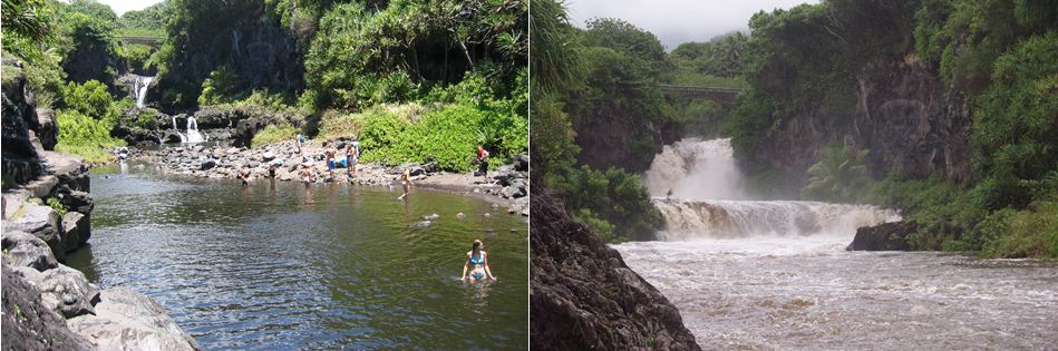
Near here was ʻOheʻo; here was a succession of several waterfalls tumbling from one pool into another and so on up the gulch.  (One interpretation of the name Oheo is “moving origin” – suggesting all pools as one (Yardley.))

In order to entertain guests and promote tourism in East Maui, employees at Fagan’s Inn crafted a legend that these pools had been reserved exclusively for Hawaiian Royalty and, therefore, were considered a sacred site.  (Cusick)

Billed as Hawaiʻi’s “Seven Sacred Pools” to attract tourists, ʻOheʻo Gulch actually has a series of 24 bowls that carry water down the slopes of 10,023-foot Mount Haleakalā to the sea.  (NY Times)

Then in the 1960s, Kīpahulu residents Charles Lindbergh and Sam Pryor, and philanthropist Laurance Rockefeller, concerned that public use of this area may be lost, worked to protect it.  Through their efforts, Kīpahulu Valley and ʻOheʻo Gulch became the Kīpahulu District of Haleakala National Park on January 10, 1969.  (NPS)

This part of the Park is located about 15-minutes past Hāna town, near mile marker 42 on the Hāna Highway (Road to Hana) after it turns into Highway 31.   Attractions include the ʻOheʻo Pools, a car-accessible campground and several maintained trails, such as the four-mile Pipiwai Loop Trail to Waimoku waterfall.

The image shows some of the ʻOheʻo pools.  In addition, I have added some other images in a folder of like name in the Photos section on my Facebook and Google+ pages.

Follow Peter T Young on Facebook  

Follow Peter T Young on Google+    

Follow Peter T Young on LinkedIn  

© 2014 Hoʻokuleana LLC

Filed Under: Place Names, Economy Tagged With: Kaupo, Oheo, Hawaii, Hana, Haleakala, Maui, Piilani, Paul Fagan, Seven Sacred Pools, Haleakala National Park, Hotel Hana, Kipahulu

Images of Old Hawaiʻi

People, places, and events in Hawaiʻi’s past come alive through text and media in “Images of Old Hawaiʻi.” These posts are informal historic summaries presented for personal, non-commercial, and educational purposes.

Info@Hookuleana.com

Connect with Us

  • Email
  • Facebook
  • LinkedIn
  • Twitter
  • YouTube

Recent Posts

  • Nāhiku Rubber Company
  • For the Birds
  • James Otis
  • Raising the United States Flag
  • Kamehameha III’s Secret Agreement of US Annexation
  • Daguerreotype
  • Wahiawā

Categories

  • General
  • Ali'i / Chiefs / Governance
  • Buildings
  • Missionaries / Churches / Religious Buildings
  • Hawaiian Traditions
  • Military
  • Place Names
  • Prominent People
  • Schools
  • Sailing, Shipping & Shipwrecks
  • Economy
  • Voyage of the Thaddeus
  • Mayflower Summaries
  • American Revolution

Tags

Air Mail Alii Andrew Johnson Charles James McCarthy Common Law cork Economy Environmental Education Famine Foods Farming Fort Weaver Future Farmers of America General Meeting Greek Greek Orthodox Hakipuu Halekii Heiau Holoku Hotel Lexington Ice Floe Isaac Harbottle John Lewis Joseph Atherton Richards Kalaihaohia Kaunakakai Kealakekua Bay Lanikai Store Luluku Manapua Mary Castle Maui High School Middle School Nationality Navy Niitakayama Nobore Pacific Fur Company Pahua Pele's Hair Ranching School Thomas ap Catesby Jones Tutasi Universal Remedy Volcano Stables War Memorial Municipal Auditorium

Hoʻokuleana LLC

Hoʻokuleana LLC is a Planning and Consulting firm assisting property owners with Land Use Planning efforts, including Environmental Review, Entitlement Process, Permitting, Community Outreach, etc. We are uniquely positioned to assist you in a variety of needs.

Info@Hookuleana.com

Copyright © 2012-2021 Peter T Young, Hoʻokuleana LLC


Loading Comments...