The south-eastern section of the island of Maui, comprising the districts of Hāna, Kīpahulu, Kaupo and Kahikinui, was at one time a Royal Center and central point of kingly and priestly power.
This section of the island was prominent in the reign of Kekaulike, and has Maui’s largest heiau (Piʻilanihale Heiau – near Hāna.) Others also seated their power here.
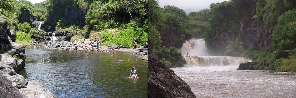
Long before the first Europeans arrived on Maui, Kīpahulu was prized by the Hawaiian aliʻi for its fertile land and abundant ocean.
The first written description of Kīpahulu was made by La Pérouse in 1786 while sailing along the southeast coast of Maui in search of a place to drop anchor:
“I coasted along its shore at a distance of a league (three miles) …. The aspect of the island of Mowee was delightful. We beheld water falling in cascades from the mountains, and running in streams to the sea, after having watered the habitations of the natives, which are so numerous that a space of three or four leagues (9 – 12 miles, about the distance from Hāna to Kaupō) may be taken for a single village.” (Bushnell)
“But all the huts are on the seacoast, and the mountains are so near, that the habitable part of the island appeared to be less than half a league in depth. The trees which crowned the mountains, and the verdure of the banana plants that surrounded the habitations, produced inexpressible charms to our senses …”
“… but the sea beat upon the coast with the utmost violence, and kept us in the situation of Tantalus, desiring and devouring with our eyes what it was impossible for us to attain … After passing Kaupō no more waterfalls are seen, and villages are fewer.” (Bushnell)
With the development of the whaling industry on the island in 1880s Kīpahulu population started to decline as people moved to main whaling ports, such as Lāhainā.
In the early-1900s, one of the regular ports of call for the Inter-Island Steam Navigation Company was Kīpahulu. Steamships provided passenger service around Maui and between the islands.
Kīpahulu Landing also provided a way for growers and ranchers to ship their goods to markets. Today the land where Kīpahulu Landing existed is private but protected with a conservation easement, overseen by the Maui Coastal Land Trust (now part of the Hawaiian Islands Land Trust.)
A famous Kīpahulu resident was Charles Lindbergh. He was the first to make a solo nonstop flight across the Atlantic Ocean. Other pilots had crossed the Atlantic before him; but Lindbergh was the first person to do it alone nonstop.
“Early in the morning on May 20, 1927 Charles Lindbergh took off in The Spirit of St. Louis from Roosevelt Field near New York City. Flying northeast along the coast, he was sighted later in the day flying over Nova Scotia and Newfoundland.”
“From St. Johns, Newfoundland, he headed out over the Atlantic, using only a magnetic compass, his airspeed indicator, and luck to navigate toward Ireland.” (New York Times, May 21, 1927)
“On the evening of May 21, he crossed the coast of France, followed the Seine River to Paris and touched down at Le Bourget Field at 10:22 pm. … A frenzied crowd of more than 100,000 people gathered at Le Bourget Field to greet him. ” (New York Times, May 21, 1927)
Lindbergh was introduced to Maui by his friend Sam Pryor, a Pan American Vice President and supporter of his flight across the Atlantic. Having first visited Pryor’s home near Hana, Lindberg later acquired land next to him and built his house.
Lindbergh died of cancer on Aug. 26, 1974, in his home on Maui. He was buried on the grounds of the Palapala Hoʻomau Church. (Pryor died in 1985 and is buried there, too – as well as Sam’s six gibbons.)
Kīpahulu’s Palapala Hoʻomau Church started construction in 1857 and was completed in 1862; it was restored in 1965 (with a lot of help from Lindberg and Pryor.)
In January 2012, the Palapala Hoʻomau Preservation Society was created to care for the Church. For many years, an endowment administered by the Hawai‘i Conference Foundation, set up by the Lindbergh and Pryor families, provided funds for maintenance and upkeep of the property. (hcucc)
In recent years, the need for restoration work on the church has gone beyond what the endowment fund can provide. Although there is no regular worshipping community at Palapala Hoʻomau, the historical significance of the church and graveyard, as well as the number of visitors who come to the property each year, led the Hawai‘i Conference Foundation to find a solution. (hcucc)
Mike Love of the Beach Boys later bought the Lindberg home, a 5-acre estate, down a twisting, scenic road a few miles from Hāna. Love also purchased the Pryor’s 14-acre adjacent site and house. (Los Angeles Times, December 31, 1989)