Images of Old Hawaiʻi

  • Home
  • About
  • Categories
    • Ali’i / Chiefs / Governance
    • American Protestant Mission
    • Buildings
    • Collections
    • Economy
    • Missionaries / Churches / Religious Buildings
    • General
    • Hawaiian Traditions
    • Other Summaries
    • Mayflower Summaries
    • Mayflower Full Summaries
    • Military
    • Place Names
    • Prominent People
    • Schools
    • Sailing, Shipping & Shipwrecks
    • Voyage of the Thaddeus
  • Collections
  • Contact
  • Follow

July 12, 2022 by Peter T Young 1 Comment

Fort Street Mall

In 1815, Kamehameha I granted Russian representatives permission to build a storehouse near Honolulu Harbor.  But, instead, directed by the German adventurer Georg Schaffer (1779-1836,) they began building a fort and raised the Russian flag.

They built their blockhouse near the harbor, against the ancient heiau of Pākākā and close to the King’s complex.  There are reports that the Russians used stones from Pākākā in building their facility.  (Pākākā was the site of Kaua‘i’s King Kaumuali‘i’s negotiations relinquishing power to Kamehameha I, instead of going to war, and pledged allegiance to Kamehameha, a few years earlier in 1810.)

When Kamehameha discovered the Russians were building a fort (rather than storehouses) and had raised the Russian flag, he sent several chiefs (including Kalanimōku and John Young (his advisor,)) to remove the Russians from Oʻahu by force, if necessary.

The Russian personnel judiciously chose to sail for Kaua‘i instead of risking bloodshed.  On Kaua‘i, there they were given land by Kaua‘i’s King Kaumuali‘i; the Russian Fort Elizabeth was built soon after on Kaua‘i.

The partially built blockhouse at Honolulu was finished by Hawaiians under the direction of John Young and mounted guns protected the fort.  Its original purpose was to protect Honolulu by keeping enemy or otherwise undesirable ships out.  But, it was also used to keep things in (it also served as a prison.)

By 1830, the fort had 40 guns mounted on the parapets all of various calibers (6, 8, 12 and probably a few 32 pounders.)  Fort Kekuanohu literally means ‘the back of the scorpion fish,’ as in ‘thorny back,’ because of the rising guns on the walls.  In 1838 there were 52 guns reported.

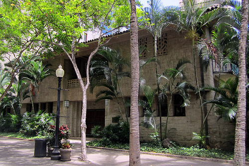
Fort Street is named after this fort; it is one of the oldest streets in Honolulu.  Today, the site of the old fort is the open space called Walker Park, a small park at the corner of Queen and Fort streets (also fronting Ala Moana/Nimitz.)

Fort Street gradually became the retail and business center of the Island throughout the 1800s and into the 1950s; it hosted several of the largest department stores in Hawaii including Kress, Liberty House and Woolworth’s.  Other stores were located along its streets.

However, by the 1940s, some foresaw the decline of downtown.  Traffic congestion, inadequate parking and competition from suburban shopping centers drained business from downtown.

In 1949, the Hawaiʻi Chapter of the American Institute of Architects made the first proposal to close Fort Street to vehicular traffic.  Nothing happened; then, with the announcement of the planned Ala Moana Shopping Center, many feared a mass exodus from downtown.

In response, the Downtown Improvement Association was formed in 1958.  It developed a master plan for downtown.  Little happened, for another 6-years.  Then, a pilot project closed Fort Street, in conjunction with the Golden Harvest Celebration.

While downtown business declined with the opening of Ala Moana Center, more studies and plans were prepared, until, finally, the City Planning Commission hired Gruen to develop a plan.

The plan called for downtown super blocks, with a system of pedestrian malls.  In January 1968, the City Council approved Gruen mall plan, after 75% of adjoining owners indicated their consent.

Fort Street Mall is 5-blocks in length (1,738-feet,) extending from Queen Street up to Beretania Street.  Construction began in June 1968 and was completed in February 1969, at a cost of $27-millon.

The architect of the Mall was Victor Gruen Associates.  The project was funded by the City & County (55%,) private owners (44%) and Board of Water Supply (1%.)

Its average width is 50-feet, at the King Street Plaza it widens to 83-feet and at Father Damien Plaza on Beretania Street it becomes 93-feet.  There are cross streets at Merchant, King and Hotel with a pedestrian underpass (and Satellite City Hall) on King Street.

Today, the Fort Street Mall Business Improvement District Association, a nonprofit corporation consisting of property owners and ground lessees adjacent to the Mall, manages the Mall by supplementing the services (primarily maintenance and security) currently provided by the City and County of Honolulu.

Like most urban settings, Fort Street Mall’s character changes block by block.  As you walk along the Mall, the businesses and the patrons indicate changes in the Mall’s identity.

Across from the Cathedral of Our Lady of Peace at the mauka end of the Mall, the Hawaii Pacific University presence gives the Mall a college feel.  Students periodically fill the Mall when classes let out and they stroll to one of the many buildings that HPU occupies on the Mall.

(Information here if from Pedestrian Malls, Streetscapes, and Urban Spaces, Harvey M. Rubenstein and The Fort Street Mall Business Improvement District Association.)

© 2022 Hoʻokuleana LLC


Filed Under: Economy, Buildings, Place Names Tagged With: Fort Kekuanohu, Fort Street, Hawaii, Oahu, Downtown Honolulu

July 6, 2022 by Peter T Young Leave a Comment

Bishop Street

On the continent or in the Islands, in the early-1800s there was limited private and public transportation and it was expensive. Thus, workers’ homes were always within two miles of downtown – less than an hour’s walk.   For these reasons cities of the mid-1800s were virtually all small, dense and on the water.

Hawaiʻi’s streets, for the most part, started out as trails that were widened and straightened, as horses, buggies and then transit became available.  In Honolulu, over time, trails headed mauka following and crossing the Nuʻuanu River, or headed southerly (to Kālia – Waikīkī) or easterly (toward Mānoa.)

Some of the present downtown Honolulu street alignments have origins dating back to 1809. It was about this time that Kamehameha the Great moved his capital from Waikīkī to what is now downtown Honolulu.

A large yam field (pa uhi), footpaths and other sites that existed then, served as the alignment for future streets.  The field’s rock walls along its edges would later border King, Alakea, Beretania and Nuʻuanu Streets.

In 1825, Andrew Bloxam (naturalist aboard the HMS Blonde) noted in Honolulu that, “The streets are formed without order or regularity.  Some of the huts are surrounded by low fences or wooden stakes … As fires often happen the houses are all built apart from each other.  The streets or lanes are far from being clean …” (Clark, HJH)

In 1838, a major street improvement project was started. Honolulu was to be a planned town. Kinaʻu (Kuhina Nui Kaʻahumanu II) published the following proclamation: “I shall widen the streets in our city and break up some new places to make five streets on the length of the land, and six streets on the breadth of the land… .” She designated her husband, Governor Mataio Kekūanāoʻa, to head the project.

As early as 1838, sidewalks along Honolulu streets were constructed, usually of wood.  Paved streets were unknown until 1881; in that year, Fort Street was paved.

In 1845, Commander Charles Wilkes criticized the city by saying: “The streets, if so they may be called, have no regularity as to width, and are ankle-deep in light dust and sand … and in some places, offensive sink-holes strike the senses, in which are seen wallowing some old and corpulent hogs.”

It wasn’t until 1850 that streets received official names.  On August 30, 1850, the Privy Council first named Hawaiʻi’s streets; there were 35-streets that received official names that day (29 were in Downtown Honolulu, the others nearby.)

Before that, many of the streets had multiple names – mostly related to who or what was on them.  Honolulu’s first street names were printed on wooden sign posts, in both English and Hawaiian.  In that same meeting, they officially named the City of Honolulu and designated it the capital of the kingdom.

The first sidewalk made of brick was laid down in 1857 fronting a shop on Merchant Street; Hawaiʻi’s first concrete sidewalk (it already had a brick sidewalk) was poured in front of a store on Queen Street in 1886.

As Honolulu grew, so did the number of streets.  One relative latecomer to that list was Bishop Street – running mauka-makai, through what is now the core of the downtown business district.

In earlier times, the main streets were Fort or Nuʻuanu (mauka-makai) and Beretania, Merchant and Queen (heading relatively northwest-southeast.)  Back then, if you wanted to go up to Nuʻuanu, you took … Nuʻuanu Street.

Bishop Street came into existence around the turn of the century (about 1900.)  Initially, it was only a couple of blocks long, between Queen and Hotel Streets.

By 1923, it extended makai to the harbor (absorbing (and realigning) the former Edinburgh Street) – still no further extension mauka.  By 1934, it extended mauka to Beretania (it absorbed (and realigned) Garden Street.)

In 1949, Bishop only went to Beretania – with no further mauka extension (it finally popped through and extended/connected to the Pali Highway and became the windward gateway into “Town.”)

Named for Charles Reed Bishop (1822 – 1915), banker, financer, philanthropist and public official and his wife Princess Bernice Pauahi Bishop (1831-1884), great-granddaughter of King Kamehameha I and last surviving heir – whose will and landholdings established the Kamehameha Schools.

The couple lived for many years near the site of Bishop Trust Building (1000 Bishop Street) – their property was known as Haleʻākala (built by Pauahi’s father Abner Paki;) the building itself is called Aikupika.)  When Bishop Street was created, it cut through their property.

CR Bishop came to Honolulu just before the California gold rush of 1849. Mr. Bishop married Bernice Pauahi Paki, daughter of high chief Abner Paki.  In 1853, he founded Bishop and Company Bank, now First Hawaiian Bank.

Do you remember the Big Five?

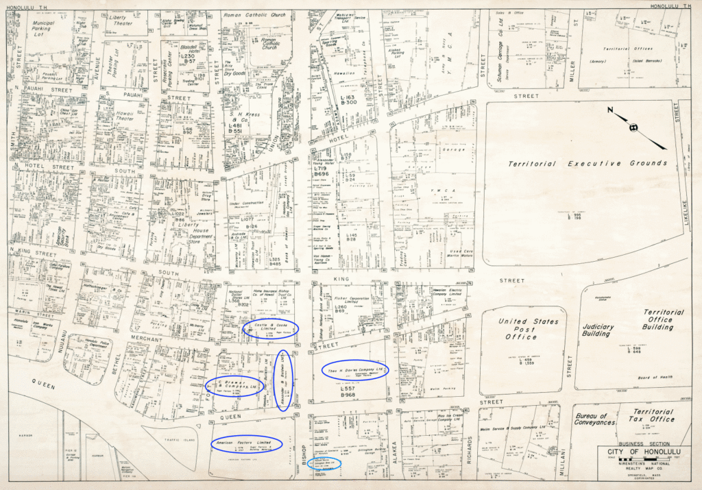
Look at the 1950 map of Honolulu.  Did you notice their placement on Bishop Street (and to each other) back then?

Five major companies emerged to provide operations, marketing, supplies and other services for the plantations and eventually came to own and manage most of them.  They became known as the Big 5: Amfac – Hackfeld & Company (1849;) Alexander & Baldwin (1870;) Theo H. Davis (1845;) Castle & Cooke (1851) and C. Brewer – (1826.)

Although it took a while to be formed, Bishop Street was and continues to be the center of Hawai‘i commerce and banking – and “the” address to have for your business.

The image is a view toward Diamond Head looking from Fort Street down King Street;   Haleʻākala (the Bishop’s house, is marked as “2”.  This was taken in 1855.

© 2022 Hoʻokuleana LLC

Filed Under: Prominent People Tagged With: Bishop Street, Hawaii, Bernice Pauahi Bishop, Honolulu, Downtown Honolulu, Paki

June 1, 2022 by Peter T Young 1 Comment

Size Matters

In expanse, Honolulu is the “largest” city in the world. Whoa … let’s take a look at what this means.

Downtown Honolulu used to be known as Kou, a district roughly encompassing the area from Nuʻuanu Avenue to Alakea Street and from Hotel Street to Queen Street (which, then, was the edge of the waterfront) – essentially the heart of the present downtown.

Honolulu Harbor, known as Kuloloia, was entered by the first foreigner, Captain William Brown of the English ship Jackall, in 1794. He named the harbor Fair Haven (some other foreign captains referred to it as Brown’s Harbor.)

The name Honolulu (with numerous variations in spelling) soon came into use. In the 1800s, the City of Honolulu was the area near the harbor which is now referred to as downtown Honolulu.

Today, some of us simply call it “Town.”

OK, so what really makes up the present day City & County of Honolulu … and how big is it?

In expanse, Honolulu is the “largest” city in the world.  We know it includes the island of Oʻahu; but that’s not all.  Let’s take a look at how and what makes up Honolulu – to get there, though, we first need to wade through some political and legal mumbo jumbo.

The State Constitution states that the area of the State includes the land, reefs and archipelagic waters:
“Hawaiʻi Constitution; Article XV – State Boundaries; Section 1.  The State of Hawaiʻi shall consist of all the islands, together with their appurtenant reefs and territorial and archipelagic waters, included in the Territory of Hawaiʻi on the date of enactment of the Admission Act, except the atoll known as Palmyra Island, together with its appurtenant reefs and territorial waters; but this State shall not be deemed to include the Midway Islands, Johnston Island, Sand Island (offshore from Johnston Island) or Kingman Reef, together with their appurtenant reefs and territorial waters.”

The Constitution also gives the legislature the authority to create Counties and other political subdivisions: “Article VIII – Local Government Creation; Section 1.  The legislature shall create counties, and may create other political subdivisions within the State, and provide for the government thereof.  Each political subdivision shall have and exercise such powers as shall be conferred under general laws.”

State law (Hawaiʻi Revised Statutes) says the archipelagic waters and smaller islands are included when describing districts: Hawaiʻi Revised Statutes – §4-3 Districts include archipelagic waters, etc.  Each of the districts includes archipelagic waters and smaller islands adjacent thereto.  (Archipelagic means an expanse of water with many scattered islands.  (Lee))

So, before we see what “Honolulu” really is, let’s look at the make-up of the State.

Hawaiʻi is geographically an archipelago. It consists of eight main islands, plus a chain of islands extending 1,100-miles to the northwest.  Johnston Atoll (Kalama), Palmyra Island and Kingman Reef to the south of Hawaiʻi were part of the Kingdom of Hawaiʻi, but the Admission Act excluded these from the geographical boundaries of the State of Hawaiʻi. (Van Dyke)

The Main Hawaiian Island group consists of the following islands:  Hawaiʻi, Maui, Oʻahu, Kauaʻi, Molokai, Lānaʻi, Niʻihau, Kahoʻolawe, Molokini, Lehua and, Kaʻula.

Papahānaumokuākea (Northwestern Hawaiian Islands) consists of all islands, atolls, reefs and shoals in the Hawaiian Archipelago northwest of Kauaʻi and Niʻihau.   All islands, atolls, reefs and shoals in the Hawaiian Archipelago, except for the Midway Islands, are included in the State of Hawaiʻi under the Admission Act, the State Constitution and the Hawaiʻi Revised Statutes.

Nine larger islands, or island groups, in the Northwestern Hawaiian Islands are: Nihoa, Necker Island, French Frigate Shoals, Gardner Pinnacles, Maro Reef, Laysan Island, Lisianski Island, Pearl and Hermes Atoll, and Kure Atoll (southeast to northwest.)

Many of these islands, or groups of islands, actually consist of many islets; for example, French Frigate Shoals contains 13 specific islets. The nine major islands, or groups of islands, range in size from Maro Reef with less than one acre to Laysan Island with 913 acres.

OK, some more political and legal mumbo jumbo.  The origin of county government within the American context is found in the Organic Act (June 14, 1900) which created the Territory of Hawaiʻi and which gave it the authority to establish municipalities.

The Territorial Legislature made a first attempt at creation of the four counties in 1903 (Act 31;) however, in 1904, the Territorial Supreme Court voided that effort on procedural grounds. The Legislature’s second attempt in 1905, “The County Act” (Act 39,) was successful, though it required an override of a veto by the Territorial Governor.  (Konishi)

The City and County of Honolulu consists of the island of Oʻahu, all other islands not included in any other county and adjacent waters thereto. (Legislative Reference Bureau)  Essentially, this means the City and County of Honolulu (“Honolulu”) covers all of Oʻahu (and its surrounding islets) plus the Northwestern Hawaiian Islands (except Midway.)

As an example of the expansive size of the archipelago, if you put the Big Island on Washington DC, Kure Atoll would be in Bismarck North Dakota.  San Francisco to New York is 2,800 to 2,900 miles; the entire Hawaiʻi chain stretches over 1,500 miles – more than halfway across the continent.  (Much of that is “Honolulu.”)

While Hawaiʻi is the world’s most-isolated, populated-place, we are about: 2,500-miles from the US mainland, Samoa & Alaska; 4,000-miles from Tokyo, New Zealand & Guam, and 5,000-miles from Australia, the Philippines & Korea.  We sometimes overlook the size of our largest City, Honolulu.

There are some things that get in the way of determining the actual “area” of Honolulu.  In part, there is disagreement on the status of the archipelagic waters (and whether it is appropriate to include these in the “area” of Honolulu) – especially in the marine expanse between Kure and Kauaʻi.

The international community has recognized the special links between coastal peoples and their adjacent waters repeatedly, and the 200-nautical-mile exclusive economic zone and the expanded 12-nautical-mile territorial sea are premised upon these links.  (Van Dyke)

Some have suggested the linkage of “historic waters” (in and around the islands, including the connecting channels in between.) The linkages are clearer within the Main Hawaiian Islands, maybe not so much to the northwest.  If not in overall area (land and connecting water,) Honolulu is clearly the largest city in expanse from Kure to Oʻahu.

© 2022 Hoʻokuleana LLC

Filed Under: General, Place Names Tagged With: Northwestern Hawaiian Islands, Papahanaumokuakea Marine National Monument, Honolulu, Oahu, Downtown Honolulu, Kou, Hawaii

April 21, 2022 by Peter T Young 1 Comment

Sliver of a Building

In 1841, on the makai side of the road (Merchant Street,) from Nuʻuanu to Kaʻahumanu Street (now the breezeway through the Harbor Court,) were empty lots, with blocks of coral for fences near the corner of Merchant and Fort streets, on the makai side of the street, were the premises of Mr. William French.  (Maly)

French first came to Hawaiʻi in 1819.  He settled in Honolulu and established himself as a leading trader. Financial success during the next decade made French known as “the merchant prince.”  He also had property in Kawaihae, on the Island of Hawaiʻi.  There, in 1835, French hired John Parker as bookkeeper, cattle hunter and in other capacities.  (Wellmon)

John Parker later purchased 640-acres (1850,) then another 1,000-acres (1851) and leased land in the Waikoloa region from Kamehameha III – these formed the foundation for the future Parker Ranch.

By 1840, French made numerous shipments of live cattle to Honolulu. These cattle were fattened in the pasture close to Waimea then driven to Kawaihae and transported to Honolulu to supply the numerous whaling ships that visited the port each fall.  (Wellmon)

French’s Honolulu premises extended from Kaʻahumanu to Fort Street, surrounded by a high picket fence with some hau trees standing just within the line of the fence. The building was quite a sizable one of wood, with a high basement and large trading rooms above. Mr. French was one of the oldest residents and a person of considerable influence.  (Maly)

The property was sold to James Austin, who sold it in 1882 to James Campbell, who owned the adjacent land on the Diamond Head side (fronting Fort Street.)  He built the “Campbell Block,” a large building that included uses such as storage, shops and offices.

Merchant Street was once the main street of the financial and governmental functions in the city, and was Honolulu’s earliest commercial center.  Dating from 1854, the remaining historic buildings along this road help tell the story of the growth and development of Honolulu’s professional and business community.

A great deal of the economic and political history of Hawaiʻi was created and written by the previous occupants of these buildings. Ranging from banks to bars and post office to newspapers, they have paid silent witness to the creation of present day Hawaiʻi.  (NPS)

Today, we still see these remnants of the past:  Melchers (1854,) the oldest commercial building in Honolulu; Kamehameha V Post Office (1871;) Bishop Bank (1878,) now known as the Harriet Bouslog Building; The Friend Building (1887 and 1900,) the site of the Oʻahu Bethel Church established in 1837; Royal Saloon (1890,) now Murphy’s; TR Foster Building (1891,) forerunner to Hawaiian Airlines;  Bishop Estate Building (1896;) Stangenwald Building (1901,) the tallest structure in Hawaiʻi until 1950; Judd Building (1898;) Yokohama Specie Bank (1909) and Honolulu Police Station (1931,) one of the earliest police forces in the world, dating to 1834.

Then, in 1902, near tragedy struck when “One of the hardest fights in the history of the Honolulu Fire Department was experienced Saturday afternoon, when a fire broke out in the middle of the Hawaiian Hardware Company’s warehouse.  For two hours the whole block bounded by Merchant and Queen, Fort and Kaahumanu streets, was in danger.” (Hawaiian Star, August 25, 1902)

“The fire is said to have been caused by an accident with gasoline in the warehouse. An order for gasoline for Young Bros. launch had been received and was being filled.”  (Hawaiian Star, August 25, 1902)

The Campbell Block survived (at least that fire.)

Then, on October 11, 1964, the Sunday Star-Bulletin and Advertiser noted, “Office-Parking Building Planned by Campbell Estate on Fort Street.”

Plans called for a combined office and parking structure to replace the 2-story Campbell Block on Fort and Merchants Streets; this new building was considered an important part of the redevelopment of downtown Honolulu.  (Adamson)   The new building was completed in May 1967.

So, the Campbell Block is gone … well, sort of.

You see, a fragment of the Campbell Block remains.  It was interconnected with the adjoining Bishop Estate Building and removing it all would harm its neighbor; so, a part was retained in-place.

As you walk down Merchant Street, between Fort and Bethel (across from the Pioneer Plaza loading and parking structure access,) take a look at the (now obvious) sliver of a building; it was once the Campbell Block (and the area of the former establishment of merchant William French.)

© 2022 Hoʻokuleana LLC

Filed Under: Buildings, Economy, Prominent People Tagged With: Merchant Street, Campbell Block, William French, John Parker, Hawaii, Honolulu, Oahu, Downtown Honolulu, James Campbell

March 10, 2022 by Peter T Young 1 Comment

“Build me a house like that”

Princess Ruth wrote to Lot Kamehameha and asked that he “fence the lot at Kaakopua with boards and to put up a gate large enough for carriages to enter”, as well as “furnish lumber for a house”.  (Zambucka)

“The two storied wooden frame residence of Emma St. of Princess Ruth was destroyed by fire during the absence in Hawaiʻi.  A valuable wardrobe, mementos of chief families, jewelry etc. was lost.”  (Honolulu Advertiser, October 18, 1873; Zambucka)

Having lost her house, Princess Ruth Luka Keanolani Kauanahoahoa Keʻelikōlani sought to rebuild.  The area where the home was located was known as Kaʻakopua.

“It is said … that in looking over various plans for the construction of a mansion on Emma Street, she was particularly struck with those of a normal school building in the States.”  (Hawaiian Gazette, October 1, 1895)

“Drawing those plans from among many others she said in her imperious manner to the architect standing nearby, ‘Build me a house like that.’”    (Hawaiian Gazette, October 1, 1895)  Thus began the construction of a home; she named it Keōua Hale.

The main architect behind new structure was Charles J. Hardy, an American from Chicago, employed at the Enterprise Planing Mill in Honolulu. The gaslit interior of the mansion was celebrated for its ornate plaster work and frescoes.  It was the most expansive residence of the time; it was larger than ʻIolani Palace.

The house was completed in 1883; however, Princess Ruth Keʻelikōlani never lived in the palace. She became ill immediately after the house warming and birthday luau.

She returned to Huliheʻe, her Kailua-Kona residence, where they believed she would more quickly regain her health.  On May 24, 1883, Keʻelikōlani died at the age of fifty-seven, in her traditional grass home in Kailua-Kona.

At her death, Keʻelikōlani’s will stated that she “give and bequeath forever to my beloved younger sister (cousin), Bernice Pauahi Bishop, all of my property, the real property and personal property from Hawaiʻi to Kauaʻi, all of said property to be hers.” (about 353,000 acres, which established the land-base endowment for Pauahi’s subsequent formation of Kamehameha Schools.)

The palace was inherited by Princess Bernice Pauahi Bishop; she and her husband, Charles Reed Bishop lived in house.  Pauahi passed away in the house a year later (October 16, 1884.) “(F)rom the hour of her death until the morning of her funeral, it rained continuously, until, at the appointed time the heavens cleared, and the sun shone brightly”.  (KSBE)

In her will, Pauahi initially intended to devise Kaʻakopua to Queen Emma.  However, in her later codicils (amendments,) Pauahi devised “the Ili of “Kaʻakopua”, extending from Emma to Fort Street and also all kuleanas in the same, and everything appurtenant to said premises” to her husband, “to hold for his life, remainder to my trustees.”  (KSBE)

On April 9 1885, the first meeting of the Bernice Pauahi Bishop Trust Board of Trustees was held at Keōua Hale 21 Emma Street with Bishop chosen chairman for the evening.  (KSBE)

But the house was not destined to be the home for Kamehameha Schools.  Rather, it had the honor of serving as the campus of the first public high school in Honolulu.

“The Board of Education used every means in its power to obtain the building” (Hawaiian Gazette, October 1, 1895)  “(D)uring talks to make the house into a school, there soon were people approving and praise this conversion into a high school. The Board of Education immediately sought to obtain the house, and were fortunate to get it at a fair price ($600,000.)”  (Kuokoa, October 12, 1895)

However, the idea of the purchase was not without its detractors.

“The stupidity of the Board of Education has been made clear. The Legislature has not approved the money to purchase Kaʻakopua and Keōua Hale. This is a huge sum of money, and it is better if they purchased some other land and built buildings for the high school, and not that beautiful house which will cost a lot to clean it up, as a place for a few people to live haughtily and snobbily off the money of the Government. It is true!”  (Makaʻāinana, 8/12/1895)

The DOE purchased the property from the Bishop Estate on June 27, 1895.  (DOE, Star Advertiser)  “(E)verything (moved) forward, expeditious preparations (were) made to begin school soon, when regular school starts. The nation is proud to obtain this schoolhouse to enroll and teach children in higher learning than that taught at the other schools which teach general knowledge.”  (Kuokoa, October 12, 1895)

So began Kula Kiekie o Honolulu (Honolulu High School.)

“The instructors of this school are, Prof. M. M. Scott, principal; J. Lightfoot, teacher of Mathematics and Latin; Miss Brewer and Miss Needham, grammar teachers; Miss Beckwith, art teacher; and Miss Tucker, a teacher of singing.”  (Kuokoa, October 12, 1895)

“This institution has been developing satisfactorily during the period under review. It is not accredited at any of the universities of America, and in my opinion it is not desirable that it be so accredited. The plan of leaving each of our graduates to enter college or fail to do so on his own merits, as recent experience indicates, will produce results creditable to all concerned.”

“Besides, the preparation of candidates for college entrance examinations is but a small part of the work of a high school in Honolulu. The course of study should be such as will fit for life, and the matter of fitting for college should be relegated to its own subordinate place.”

“The Honolulu High School is especially adapted to the needs of those who speak the English language as a mother tongue and to no others. It accommodates but passably a few of the exceptionally bright pupils of the much larger class who have the language to learn after entering school. Taking into account the number of English speaking persons in Honolulu, it will be observed that the high school is of very creditable size.”  (Report of the Minister of Public Instruction, 1899)

In 1907, Honolulu High School moved out of Keōua Hale to the corner of Beretania and Victoria Streets. The school’s name was then changed to President William McKinley High School, after President William McKinley, whose influence brought about the annexation of the Hawaiian Islands to the United States.

The educational needs of Honolulu exceeded the space of Princess Ruth’s palace for several reasons. In 1920, a report was published on the survey of schools conducted by the Bureau of Education of the Federal Department of the Interior.

The report noted that typical middle class families in America were sending their children to public secondary schools, but in Hawaii, public schools were so few and geographically isolated, that many had to go to private schools or were forced to drop out.

Therefore, the commission recommended the establishment of secondary or junior high schools which should offer more academic and vocational choices to feed various high schools. And Hawaii, at this time, tried very hard to be American. (NPS)

Later, at Kaʻakopua, new school buildings replaced Keōua Hale.  Upon its official opening in 1927, the Advertiser news article described the layout which has remained relatively intact:

“Entering the main portal of the new plant, the visitor finds the principal’s office at the left and teachers’ room at the right. … Four large classrooms flank the main corridor and behind them are the kitchen and the dining pavilions. …”

“There are 11 classrooms in the old wing and in the new wing there are six classrooms on the main floor and seven on the second story. … The 31 classroom building had room for 1,500 pupils.”  (NPS)

Though called Central Middle School, as you drive down South Kukui Street (between Queen Emma Street and Nuʻuanu Pali Highway) the name “Keʻelikōlani School” is noted on the building.

DOE suggests the school there was never called that.  (Unfortunately, DOE records were lost in a fire.)  However, a July 2, 1917 Star Bulletin article notes Pedro Augusta as the Keʻelikōlani School janitor (no other school was named Keʻelikōlani.)

In October of 1994 the buildings of Central Intermediate were placed on the Hawaiʻi Register of Historic Places. The school continues to honor Princess Ruth’s generosity in providing a location for their school by celebrating her birthday February 9 of each year.  (Central Middle School)

In September 2021, the Hawaiʻi State Board of Education (BOE) approved the restoration of Central Middle School to its former name honoring Princess Ruth Keanolani Kanāhoahoa Keʻelikōlani. The change was effective immediately. Princess Ruth Keʻelikōlani Middle School currently serves 336 students in grades six through eight.

© 2022 Hoʻokuleana LLC

Filed Under: Ali'i / Chiefs / Governance, Place Names, Schools Tagged With: Hawaii, Oahu, Downtown Honolulu, Princess Ruth, McKinley High School, Honolulu High School, Keoua Hale, Princess Ruth Keelikolani

  • « Previous Page
  • 1
  • 2
  • 3
  • 4
  • 5
  • 6
  • …
  • 9
  • Next Page »

Images of Old Hawaiʻi

People, places, and events in Hawaiʻi’s past come alive through text and media in “Images of Old Hawaiʻi.” These posts are informal historic summaries presented for personal, non-commercial, and educational purposes.

Info@Hookuleana.com

Connect with Us

  • Email
  • Facebook
  • LinkedIn
  • Twitter
  • YouTube

Recent Posts

  • Mikimiki
  • Doubtful Island of the Pacific
  • John Meirs Horner
  • Prostitution
  • Malukukui
  • Fight for Parker Ranch
  • Kilauea Masonic Lodge

Categories

  • Mayflower Summaries
  • American Revolution
  • General
  • Ali'i / Chiefs / Governance
  • Buildings
  • Missionaries / Churches / Religious Buildings
  • Hawaiian Traditions
  • Military
  • Place Names
  • Prominent People
  • Schools
  • Sailing, Shipping & Shipwrecks
  • Economy
  • Voyage of the Thaddeus

Tags

Albatross Al Capone Ane Keohokalole Archibald Campbell Bernice Pauahi Bishop Charles Reed Bishop Downtown Honolulu Eruption Founder's Day George Patton Great Wall of Kuakini Green Sea Turtle Hawaii Hawaii Island Hermes Hilo Holoikauaua Honolulu Isaac Davis James Robinson Kamae Kamaeokalani Kamanawa Kameeiamoku Kamehameha Schools Lalani Village Lava Flow Lelia Byrd Liliuokalani Mao Math Mauna Loa Midway Monk Seal Northwestern Hawaiian Islands Oahu Papahanaumokuakea Marine National Monument Pearl Pualani Mossman Queen Liliuokalani Thomas Jaggar Volcano Waikiki Wake Wisdom

Hoʻokuleana LLC

Hoʻokuleana LLC is a Planning and Consulting firm assisting property owners with Land Use Planning efforts, including Environmental Review, Entitlement Process, Permitting, Community Outreach, etc. We are uniquely positioned to assist you in a variety of needs.

Info@Hookuleana.com

Copyright © 2012-2024 Peter T Young, Hoʻokuleana LLC


Loading Comments...