Images of Old Hawaiʻi

  • Home
  • About
  • Categories
    • Ali’i / Chiefs / Governance
    • American Protestant Mission
    • Buildings
    • Collections
    • Economy
    • Missionaries / Churches / Religious Buildings
    • General
    • Hawaiian Traditions
    • Other Summaries
    • Mayflower Summaries
    • Mayflower Full Summaries
    • Military
    • Place Names
    • Prominent People
    • Schools
    • Sailing, Shipping & Shipwrecks
    • Voyage of the Thaddeus
  • Collections
  • Contact
  • Follow

January 12, 2024 by Peter T Young Leave a Comment

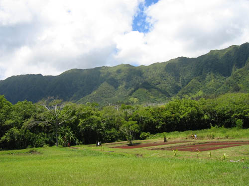
Maunawili

While the valley is known as Maunawili, the word itself is a contraction of “twisted mountain.”

Archaeologists tell us that inland migration in the eleventh and twelfth centuries generally followed Maunawili and Kahanaʻiki streams into Maunawili valley with population concentrated at Kukanono (around the Castle Hospital area) and Maunawili, where fresh water was plentiful in both places.

In ancient times, the natural springs of Maunawili fed a network of streams that laced the valley: Makawao, furthest back in the valley; Ainoi, Maunawili, Omao and Palapu, all of which flowed into a common tributary to Kawainui.  A separate branch further toward the Pali, Kahana’iki, also fed the marsh.

Irrigated loʻi – interspersed with ti and popolo (black nightshade herb) plantings – stretched to Kawainui’s fishponds. There the streams fed nutrient-rich water into the ponds to nurture limu (algae) for the fish as well as to sustain lepo’ai’ai, edible mud the color of poi and the texture of haupia.

James Boyd, a British seaman (and Kamehameha confidant) is believed to be the first white landowner in the Kailua area. He and his descendants operated the Maunawili Ranch until it was acquired by William G. Irwin, a sugar factor.

The ranch was one of the largest cattle operations on Windward Oahu in the 19th century.  Irwin bought up the valley in the early-1890s as watershed to irrigate a Waimanalo sugar plantation.

In addition, he and others experimented with other crops.  At first, rice paddies replaced the taro lo’i (starting in about the 1860s.)  In 1894, Irwin’s Maunawili ranch manager, George Gibb, began planting coffee.

He expanded his planting each year thereafter until 1900, by which time over 110-acres were planted in Liberian beans (a coffee mill was later added.)  Gibb’s records show he planted “300 Carica papaya” in December of 1902, suggesting he was the first to plant solo papayas in Hawai’i.

Avocado and cacao were planted the following year.  In 1904, Kona oranges were attempted along with Eucalyptus Robusta; more Kona oranges and mangosteen, possibly for the first time in Hawaii, were tried in 1905. Koa and Chinese banyan were planted in 1906 and Kola nut in 1910.

Some of these early plantings took decades to mature. In April of 1939, the ranch manager reported fruits on trees dating back to 1905. But by then he had lost hope for Brazilian Cherries dating to 1903, an Apple variety of approximately the same time, and several other trees going back as far as 1900.

All this experimentation was a sideline to Maunawili’s value as the only promising water source for the perpetually-parched Waimanalo plantation. In 1900, to explore that promise Irwin retained M. M. O’Shaughnessy, a civil engineer celebrated for building early dams and tunnels in California and Hawaii.

O’Shaughnessy learned that, in addition to 43 inches of average annual rainfall, the plantation was irrigated by Maunawili spring “and all springs and streams east of it to the Ranch boundary, amounting in all to 1.5 million (gallons) in ordinary times and in dry seasons to one million gallons.”

If Maunawili could be tapped for another four million gallons during a four-month dry season, plantation manager George Chalmers forecast another 1,000 tons in annual sugar production.

C Brewer acquired a stake in the valley in 1910 when the sugar factor acquired Irwin’s business when he retired.  In a June 27, 1924 report, the ranch was described as “sparsely forested foothills close to the mountain wall” with indigenous Hawaiian trees: koa, kukui and some lehua.

The remaining area was largely “overrun with staghorn fern, and lower portions have a substantial growth of low guava.”

The report continued: “Here and there Java plum, waiawi, a few eucalyptus, iron wood, coffee and rubber trees are apparently thriving.”

A forest reserve line was proposed that would take in ranch land then used for pasturage, “a large portion of which . . . suitable for pineapple cultivation.” But the benefits of a reforestation program to stabilize water flow for the summer months at Waimanalo out-weighed this consideration.

Under Brewer, from 1924 through 1926, there was a massive cultivation effort with nearly 80,000 trees in the three year period. Juniper, Mahogany, Australian cedar and tropical ash were among them.

From 1927 through 1932 a total of 45 different varieties of fruit trees were introduced to the valley by Brewer ranging from Allspice to water apple. By 1931, a large number of solo papaya trees and many varieties of banana were growing plus a total of nearly 11,000-cashew trees.

The cashew plantings had resulted in “excellent growth” but a serious blight affected the blossom “if the blossom season occurs during wet weather;” the cashew nut crops had been poor.

Australian Macadamia plantings were placed between the solo papaya trees in 1936; at that time, avocados, limes, banyan and coconut trees also were carried on the ranch’s rolls.

In the summer of 1939 the UH College of Agriculture advised Brewer to embark on the cultivation of papaya at Maunawili on a large scale and the ranch manager was instructed to give the proposal serious evaluation.

That fall, the Territorial Board of Agriculture & Forestry asked for Hayden mango tree branches for propagation and permission to release pheasants in the valley.

The ranch manager was against introducing any further pheasants because they damaged young growing plants, especially papaya, and suggested doves as a better choice because they fed on weed seeds rather than plants.

Lili‘uokalani used to visit friends at the Boyd estate in Maunawili.  She and her brother King David Kalākaua were regular guests and attended parties or simply came there to rest.  Guests would walk between two parallel rows of royal palms, farewells would be exchanged; then they would ride away on horseback or in their carriages.

On one trip, when leaving, she witnessed a particularly affectionate farewell between a gentleman in her party and a lovely young girl from Maunawili.

As they rode up the Pali and into the swirling winds, she started to hum a melody weaving words into a romantic song.  The Queen continued to hum and completed her song as they rode the winding trail down the valley back to Honolulu.

She put her words to music and as a result of that 1878 visit she wrote “Aloha ‘Oe.”  (Lots of info here from Maunawili Community Association.)  The image shows ‘Maunawili Peaks (Olomana) from Kailua’ by D Howard Hitchcock (1910s.)

© 2024 Hoʻokuleana LLC

Filed Under: Ali'i / Chiefs / Governance, Place Names Tagged With: Olomana, Aloha Oe, Hawaii, Oahu, Liliuokalani, Kailua, Maunawili, James Boyd, Kawainui

January 10, 2024 by Peter T Young Leave a Comment

Honolulu Described in the First Decade of the Unified Hawaiian Islands

1810 marked the unification of the Hawaiian Islands under single rule when negotiations between King Kaumuali‘i of Kauai and Kamehameha I at Pākākā took place.  Kaumuali‘i ceded Kauai and Ni‘ihau to Kamehameha and the Hawaiian Islands were unified under a single leader.  There was peace in the Islands.

On the American and European continents, war was waging.  Twenty-nine years after the end of the American Revolution, conflict between the new US and Britain flared up, again – it lasted until 1815.

A lasting legacy of the War of 1812 was the lyrics of “The Star-Spangled Banner,” the US national anthem. They were penned by the amateur poet Francis Scott Key after he watched American forces withstand the British siege of Fort McHenry, Baltimore (named for James McHenry, Secretary of War, 1796 – 1800.)

In Europe, in 1804, Napoleon Bonaparte was crowned Emperor of France.  In 1815, as part of ongoing series of conflicts and wars in Europe, African and the Middle East, Napoleon was defeated by the Duke of Wellington at Waterloo (in what is now present-day Belgium.)

Back on the American continent, later in the decade (1818,) the US and Canada came to an agreement on their common boundary and used the 49th parallel to mark their border.  The next year, Spain ceded Florida to the US.

In the Islands, Kamehameha I, who had been living at Waikiki, moved his Royal Residence to Pākākā at Honolulu Harbor in 1809.

That year, Archibald Campbell described the Honolulu surroundings:  “Upon landing I was much struck with the beauty and fertility of the country … The village of Hanaroora (Honolulu,) which consisted of several hundred houses, is well shaded with large cocoa-nut trees.”

“The king’s residence, built close upon the shore, and surrounded by a palisade upon the land side, was distinguished by the British colours and a battery of sixteen carriage guns …”

“This palace consisted merely of a range of huts, viz. the king’s eating-house, a store, powder magazine, and guard-house, with a few huts for the attendants, all constructed after the fashion of the country.”

Kamehameha’s immediate court consisted of high-ranking chiefs and their retainers.  Those who contributed to the welfare and enjoyment of court members also lived here, from fishermen and warriors to foreigners and chiefs of lesser rank.

Today, the site is generally at the open space now called Walker Park at the corner of Queen and Fort streets (there is a canon from the old fort there) – (ʻEwa side of the former Amfac Center, now the Topa Financial Plaza, near the fountain.)

ʻEwa side of Pākākā (where Nuʻuanu Stream empties into the harbor) was the area known as Kapuʻukolo.  This is “where white men and such dwelt.”  Of the approximate sixty white residents on O‘ahu at the time, nearly all lived in the village, and many were in the service of the king.

Among those who lived here were Don Francisco de Paula Marin, the Spaniard who greatly expanded horticulture in Hawaiʻi, and Isaac Davis (Welch,) friend and co-advisor with John Young (British) to Kamehameha.

Campbell noted, “(Isaac Davis’) house was distinguished from those of the natives only by the addition of a shed in front to keep off the sun; within, it was spread with mats, but had no furniture, except two benches to sit upon. He lived very much like the natives, and had acquired such a taste for poe (poi,) that he preferred it to any other food.”

In those days, this area was not called Honolulu.  The old name for what is now the heart of downtown Honolulu was said to be Kou, a district roughly encompassing the present day area from Nuʻuanu to Alakea Streets and from Hotel to Queen Streets.

Honolulu Harbor, also known as Kuloloia, was entered by the first foreigner, Captain William Brown of the English ship Butterworth, in 1794.  He named the harbor “Fair Haven.”  The name Honolulu (meaning “sheltered bay” – with numerous variations in spelling) soon came into use.

A large yam field (what is now much of the core of downtown Honolulu – what is now bounded by King, Nuʻuanu, Beretania and Alakea Streets) was planted to provide visiting ships with an easily-stored food supply for their voyages (supplying ships with food and water was a growing part of the Islands’ economy.)

A couple years later, John Whitman noted in his journal (1813-1815,) “… Honoruru is the most fertile district on the Island. It extends about two miles from the Harbour where it is divided into two valleys by a ridge of high land. The district is highly cultivated and abounds in all the productions of these Islands.”

“The village consists of a number of huts of different sizes scattered along the front of the Harbour without regularity and the natives have lost much of the generous hospitality and simplicity that characterize those situated more remotely from this busy scene.”

Whitman goes on to note, “… everything necessary for the subsistence and comfort of man is found in the (Nuʻuanu) valley, watered by a rivulet it produces the best taro in great abundance, the ridge dividing the taro patches are covered with sugar cane.”

“The high ground yields sweet potatoes and yams and all the other productions of the Island are found in the various situations and soils adapted to their nature.”

In 1816-1817, Otto Von Kotzebue in command of a Russian exploratory expedition spent three weeks in the “Sandwich Islands.”  He gave a description of the loʻi kalo in the Nuʻuanu area:

“The valley of Nuanu (Nuʻuanu,) behind Hanarura (Honolulu,) is the most extensive and pleasant of all. … The cultivation of the valleys behind Hanarura is remarkable.  Artificial ponds support, even on the mountains, the taro plantations, which are at the same time fish-ponds; and all kinds of useful plants are cultivated on the intervening dams.”

In 1818, Peter Corney, who resided on O‘ahu as a representative of the Northwest Company and engaged in the sandalwood and other trade, noted:

“The Island of Woahoo (Oʻahu) is by far the most important of the group of the Sandwich Island, chiefly on account of its excellent harbours and good water. It is in a high state of cultivation; and abounds with cattle, hogs, sheep, goats, horses, etc., as well as vegetables and fruit of every description.”

“The ships in those seas generally touch at Ohwhyhee, and get permission from Tameameah (Kamehameha,) before they can go into the harbor of Woahoo.”

“He sends a confidential man on board to look after the vessel, and keep the natives from stealing; and, previous to entering the harbor of Honorora (Honolulu), they must pay eighty dollars harbor duty, and twelve dollars to John Harbottle, the pilot…”

“The village consists of about 300 houses regularly built, those of the chiefs being larger and fenced in. Each family must have three houses, one to sleep in, one for the men to eat in, and one for the women, – the sexes not being allowed to eat together.”

“Cocoanut, bread-fruit, and castor-oil-nut (kukui) trees, form delicious shades, between the village and a range of mountains which runs along the island in a NW and SE direction.” (Corney)

Jacques Arago, who visited Hawai‘i in 1819 with Captain Louis Claude de Saulses de Freycinet on the French ships L’Uranie and L’Physicienne, described some of the daily activities:


“At sunrise, men, women, and children quit their dwellings; some betake themselves to fishing (chiefly the women) on the rocks, or near the shore; others to the making of mats …”

“… the rest offer their little productions to, or solicit employment from, strangers, in exchange for European articles; while the masters of families repair to the public square, to witness or participate in amusements, of which they are astonishingly fond…”

The first decade of the Islands under single rule ended with the death of Kamehameha.  Prior to his death (May 8, 1819,) Kamehameha decreed that that his son, Liholiho, would succeed him in power; he also decreed that his nephew, Kekuaokalani, have control of the war god Kūkaʻilimoku.

© 2024 Hoʻokuleana LLC

Filed Under: General, Ali'i / Chiefs / Governance, Place Names Tagged With: Honolulu Harbor, Kamehameha, Hawaii, Honolulu, Oahu, Fort Kekuanohu, Kou

December 29, 2023 by Peter T Young Leave a Comment

Kūpikipikiʻō

An eruption from a vent southeast of Lēʻahi (Diamond Head) poured dense lava into the sea to build a headland. The Hawaiians called it Kūpikipikiʻō (rough (sea) or agitated (wind or storm)) because of its turbulent waters.

The waves attack the headland directly, but the shore on either side of it is protected by a reef. (MacDonald)  The black lava that formed there prompted its modern name, Black Point.

When Kamehameha and his warriors made their attack in Oʻahu in 1795, they landed from Waikīkī to Maunalua – right in this area.  More than 100-years later, around 1901, one of Black Point’s first houses was built by developer Fred Harrison.  (Star-Bulletin)

In January 1905, President Teddy Roosevelt instructed Secretary of War William H. Taft to convene the National Coast Defense Board (Taft Board) “to consider and report upon the coast defenses of the United States and the insular possessions (including Hawai‘i.)”

Based on recommendation of the Secretary of War, on January 18, 1906, President Teddy Roosevelt signed Executive Order 395-A, setting aside public lands at Kūpikipikiʻo Point for military purposes.

“From Kūpikipikiʻo Point to Waipiʻo Peninsula the line of defense is to be strengthened with field fortifications, batteries and searchlights, and as soon as the money becomes available the dirt will begin to fly and the concrete to take form, under the supervision of the army engineers.”  (Star-Bulletin, February 4, 1914)

Fort Ruger Military Reservation was established at Lēʻahi in 1906.  The Reservation was named in honor of Major General Thomas H Ruger, who served from 1871 to 1876 as the superintendent of the United States Military Academy at West Point.

The fort included Battery Harlow (1910-1943); Battery Birkhimer (1916-1943); Battery Granger Adams (1935-1946); Battery Dodge (1915-1925); Battery Mills (1916-1925); Battery 407 (1944); Battery Hulings (1915-1925) and Battery Ruger (1937-1943.)

Battery Mills was built on a 3-acre tract in the Kūpikipikiʻo Point Reservation.   Battery Mills was not technically part of Fort Ruger, but was administered by it.  The battery was armed with two 5-inch Seacoast guns.

There was a reinforced magazine for munitions, a plotting room/command bunker and an underground power room which had a generator. Those guns were later eliminated from the Army’s inventory, so the Battery was decommissioned.

Battery Granger Adams (1933 and 1935) replaced Battery Mills and consisted of two 8-inch railway guns on either side of a protected powder and shell magazine, along with a Commander’s Station and power room (it was felt that there was still a need for a gun battery at that location – it was later decommissioned in 1946.)

The conclusion of World War II and the advent of nuclear and missile warfare made the coastal batteries obsolete. Thus, in December 1955 the majority of the land was turned over to the State of Hawai‘i.

Nearby Kaʻalāwai Beach lies at the base of Diamond Head’s eastern slope, between Kuilei Cliff Beach Park (“lei stringing”) to the west and Black Point to the east.

Kaʻalāwai (“the watery rock”) is a narrow, white-sand beach with a shallow reef offshore, which makes for generally poor swimming conditions. There are only a few scattered pockets of sand on the nearshore ocean bottom.

Freshwater bubbles up between the rocks of the reef. The beach is mainly used by surfers, who paddle out to the surf spot called Brown’s, which is located just behind the reef.

An old Beach Road fronted the Kaʻalāwai oceanfront properties.  In 1959, owners of the abutting properties claimed the ownership of the old beach road; after a series of lawsuits, many of them obtained declaratory judgments which allowed them to buy the road right-of-way.

At the east end of the beach near Black Point is Shangri-La, a mansion turned museum, built by Doris Duke, the daughter of James Buchanan Duke, the founder of the American Tobacco Company, and her husband, James Cromwell, in 1937.

Upon her father’s death, Doris Duke received large bequests from her father’s will when she turned 21, 25, and 30; she was sometimes referred to as the “world’s richest girl.”

In the late 1930s, Doris Duke built her Honolulu home, Shangri La, on 5-acres overlooking the Pacific Ocean and Diamond Head.  Shangri La incorporates architectural features from the Islamic world and houses Duke’s extensive collection of Islamic art, which she assembled for nearly 60 years.

Today, Shangri La is open for guided, small group tours and educational programs. In partnership with the Doris Duke Foundation for Islamic Art – which owns and supports Shangri La – the Honolulu Museum of Art serves as the orientation center for Shangri La tours.

To get to Kaʻalāwai Beach and Cromwell’s Cove take Diamond Head Road east and turn right on Kulamanu Street and park curbside.  The beach access is at the end of Kulamanu Place.

A later building boom by the wealthy turned Black Point into one of the world’s most exclusive and expensive community.

© 2023 Hoʻokuleana LLC

Filed Under: General, Buildings, Place Names, Economy Tagged With: Doris Duke, Kaalawai, Kupikipikio, Fort Ruger, Black Point, Hawaii, Oahu, Leahi, Diamond Head, Shangri La

December 17, 2023 by Peter T Young 1 Comment

Queen’s Surf

“Hamohamo is justly considered to be the most life-giving and healthy district in the whole extent of the island of Oʻahu; there is something unexplainable and peculiar in the atmosphere of that place, which seldom fails to bring back the glow of health to the patient, no matter from what disease suffering.” (Queen Liliʻuokalani)

The Queen “derived much amusement, as well as pleasure: for as the sun shines on the evil and the good, and the rain falls on the just and the unjust, I have not felt called upon to limit the enjoyment of my beach and shade-trees to any party in politics … While in exile it has ever been a pleasant thought to me that my people, in spite of differences of opinions, are enjoying together the free use of my seashore home.”

Because of her nearby homes, they called the coastal area in this part of Waikīkī Queen’s Surf Beach.

In 1914, Mr & Mrs WK Seering of the International Harvester Co in Illinois built a home there.  A couple decades later, Fleischman’s Yeast heir, Mr CR Holmes, bought the home (he also had other Hawaiʻi property, including Coconut Island in Kāneʻohe Bay.) (ilind)

During WWII, the house was used for military retreats and other military uses.  Admiral Nimitz, General Douglas McArthur and staffs spent time there.

After World War II (and following Holmes’ death,) the City & County of Honolulu bought the property and leased it to the Spencecliff Corporation restaurant chain; it became their flagship property and operated it as the hugely popular Queen’s Surf Restaurant and Nightclub.

Sterling Edwin Kilohana Mossman (February 3, 1920 to February 21, 1986) headlined at its upstairs Barefoot Bar.  A man as versatile as he was talented, literally led a double life. A detective with the Honolulu Police Department during the day, after dark he was one of Hawaiʻi’s most popular entertainers. His diversified careers earned him the nickname “Hula Cop”. (TerritorialAirwaves)

The Barefoot Bar was ground zero for this new brand of local comedy. Mossman was the ringleader, along with the likes of Lucky Luck, a zany radio personality, and Kent Bowman, known as KK Kaumanua.  They told stories, sang songs and, when a celebrity from the Mainland happened to come by (and they did a lot), they became part of the show.  (HonoluluMagazine)

Mossman sang and did comedy and included a lot of others in the evening’s entertainment.  The footprints of many of these Island and internationally known entertainers lined the stairway up to the second floor bar.

For a while, downstairs, at the Surf Lanai, Kuiokalani (Kui) Lee sang for the crowds – inside and out of the restaurant.  During the day, the beach was crowded with sun bathers; at night it was full of Island residents listening in on Kui Lee’s long list of local favorites (he’d turn to the ocean and sing a final song to the folks on the beach.)

Born in Shanghai, China, the third child and only son of Hawaiian entertainers Billy and Ethel Lee, Kui Lee was a prolific songwriter.  Folks like Don Ho, Elvis, Tony Bennett and Andy Williams recorded and performed his songs: “I’ll Remember You,” “One Paddle, Two Paddle”, “She’s Gone Again”, “No Other Song”, “If I Had To Do It All Over Again”, “Yes, It’s You”, “Rain, Rain Go Away”, “Get On Home”, “The Days Of My Youth” and “Lahainaluna.”

“Kui was very brash, very positive about his songs,” said Kimo McVay, owner of Duke Kahanamoku’s nightclub from 1961 to ’71 and manager/promoter of Don Ho from 1963 to ’66. “He gave them to Don, and Don, of course, made them hits. When Don became a star because of that material, a national star, that’s what launched Kui. And Kui became the star of Queen’s Surf.” (star-bulletin)

Here is Kui Lee singing Days of My Youth (a reminder for me of growing up in the Islands, and the one time I was able to sit on the beach and listen to Kui Lee perform – unfortunately, Kui Lee died of cancer at the age of 34 in 1966.)  Click HERE for a YouTube for one of Kui Lee’s songs.

Queen’s surf also offered a regular lūʻau on the property.

The stories vary on the cause, but later there was a lease dispute with the City and the Queen’s Surf and the neighboring Kodak Hula Show were evicted, the Queen’s Surf was torn down (1971) and the Waikīkī beachfront area was turned into a public park.

© 2023 Hoʻokuleana LLC


Filed Under: Economy, Buildings Tagged With: Spencecliff, Hamohamo, Queen's Surf, Hawaii, Waikiki, Oahu, Queen Liliuokalani

December 7, 2023 by Peter T Young 4 Comments

Postcards, Sails, Sheets, Lights, Ads, Fires and Radio Signals

The attack on the US military installation at Pearl Harbor and other parts of Oʻahu by Japan’s Imperial military was one of the most successful surprise attacks in military history.

But an often-overlooked component of the successful attack is that the Japanese Empire had contracted with Bernard Otto Julius Kuehn, a German Nazi, to spy on the American military operations at Pearl Harbor from 1935 (an early ‘sleeper agent’ in espionage.)

The family had been contracted as agents of the Japanese government with the assistance of the Nazi Propaganda Minister Joseph Goebbels. The arrangement was promoted and negotiated by Goebbels as a byproduct of his relationship with Kuehn’s attractive 17-year old daughter, Susie Ruth.  (Washington Times)

The execution of the plan was reminiscent of “one, if by land, and two, if by sea,” the phrase coined by American poet, Henry Wadsworth Longfellow in his poem, Paul Revere’s Ride.

It references the secret signal during Revere’s ride from Boston to Concord on the verge of American Revolutionary War alerting patriots about the route the British troops would take to Concord (two lanterns were shown, the British rowed over to Cambridge.)

The Kuehns arrived in Hawaiʻi in 1935; they started their spying then.  They blended in, and waited.

No one seriously suspected that Caucasians would carry on espionage for the Empire of Japan, so Kuehn, his wife Friedel, their daughter and son, Hans Joachim, were virtually inconspicuous as a white family on the windward side.

Kuehn had houses in Hawaiʻi, lots of money, but no real job. Investigations by the Bureau and the Army, though, never turned up definite proof of spying.  (FBI)

However, every member of the family contributed towards collecting and documenting military activities at Pearl Harbor from 1935 right up to the day the bombs fell from Japanese aircraft.

Paid for his services, in three years he banked more than $70,000; one payment was $14,000 in $100 bills. They had houses in Lanikai and Kailua; these later served as the means of their intricate, yet simple, signaling system.  (Pearl Harbor Board)

The Kuehn family took various means to gather information.

Kuehn would scout the ships at Pearl Harbor.  Daughter Susie Ruth set up a beauty parlor and used it to gather gossip and random information from wives and girlfriends of the military men stationed at Pearl Harbor.  Mother Friedel kept track of all the notes.

Ten-year-old Hans was dressed in a sailor suit and with his father would walk down near the docks.  Many of the sailors thought the little guy was quite cute and some gave him unofficial “tours” of their ships.

Coached by his father, he would ask specific questions and observe everything he saw. Later he would be systematically debriefed by his parents.

The Kuehn family was not working alone; they worked with other Japanese spies attached to the Japanese consulate.

If the Consulate wanted to contact Kuehn, they would send a postcard signed “Jimmie” to his Post Office Box 1476 in Honolulu.  (Pearl Harbor Board)

On December 2, days before the attack, he provided specific – and highly accurate – details on the fleet in writing. That same day, he gave the consulate the set of signals that could be picked up by nearby Japanese submarines.  (FBI)

The set of signals contained eight combinations, each signal represented a number and each number represented the status of the naval fleet at Pearl Harbor.

No. 1 – battle fleet prepared to leave
No. 2 – scouting force prepared to leave
No. 3 – battle fleet left 1 to 3 days ago
No. 4 – scouting fleet left 1 to 3 days ago
No. 5 – air craft carriers left 1 to 3 days ago
No. 6 – battle fleet left 4 to 6 days ago
No. 7 – scout force left 4 to 6 days ago
No. 8 – aircraft carriers left 4 to 6 days ago

Signals were given that represented these respective code numbers.  Part of how they did this was to shine lights out windows and hang sheets on the laundry line.  These were done from their homes in Lanikai and Kailua (using lights in a dormer window.)

One light shining from the window between 7 and 8 pm meant No. 1; one light from 8 to 9 pm meant No. 2 and so forth for Nos. 3 and 4.  Two lights shining from the window from 7 to 8 meant No. 5, etc.  Hanging sheets on the laundry line carried the similar code.

An alternative display of the code used different patterns in the sail of Kuehn’s boat off Lanikai; a sail with/without a star and numbers at different hours represented corresponding references back to the code.

They also arranged the signal through KGMB Want Ads – different advertised items represented different numbers (ie Chinese rug, chicken farm, beauty parlor operator wanted, etc.)

Two other signaling means included garbage fires on a friend’s property on the side of Haleakala on Maui between certain times, representing different code numbers.  Signals were also sent via shortwave radio.  (Pearl Harbor Board)

Following the fateful attack of December 7, 1941, Honolulu Special Agent in Charge Robert Shivers immediately began coordinating homeland security in Hawaiʻi and tasked local police with guarding the Japanese consulate. They found its officials trying to burn reams of paper. These documents – once decoded – included a set of signals for US fleet movements.  (FBI)

All fingers pointed at Kuehn. He had the dormer window, the sailboat and big bank accounts. Kuehn was arrested the next day and confessed, though he denied ever sending coded signals. (FBI)

On February 21, 1942, just 76 days after the tragic attack on Pearl Harbor, a military court in Honolulu found Bernard Otto Julius Kuehn guilty of spying and sentenced to be shot “by musketry” in Honolulu.  His sentence was later commuted to 50 years of hard labor.

He served time in Leavenworth Penitentiary from December 1, 1942 to June 6, 1946 (when his sentence was commuted in order to deport him.)  On December 3, 1948, he was deported to Buenos Aires, Argentina.  (FBI)

Kuehn was one of 91-people convicted of spying against the United States from 1938 to 1945.  (FBI)

© 2023 Hoʻokuleana LLC

20040901-08 PRG SPY HOUSE There are two houses at 557 Kainalu in Kailua that are built very close to each other. This is the two story A fame house that is on the right side of the property. During the late 1930's it served as a den for a German spy who provided intelligence for the Japanese military leading up to the bombing of Pearl Harbor. The present owner, John Piper (225-3555) bought the houses in 1999. PHOTO BY DENNIS ODA. SEPT. 1, 2004. Nikon D2H Focal Length: 13mm White Balance: Direct sunlight Color Mode: Mode I (sRGB) 2004/09/01 12:35:19.1 Exposure Mode: Shutter Priority AF Mode: AF-C Hue Adjustment: 0¡ JPEG (8-bit) Fine Metering Mode: Multi-Pattern Tone Comp.: Auto Sharpening: Auto Image Size: Large (2464 x 1632) 1/250 sec - f/15 Flash Sync Mode: Not Attached Noise Reduction: OFF Exposure Comp.: 0 EV Lens: 12-24mm f/4 G Sensitivity: ISO 200 Image Comment: [#End of Shooting Data Section]
20040901-08 PRG SPY HOUSE There are two houses at 557 Kainalu in Kailua that are built very close to each other. This is the two story A fame house that is on the right side of the property. During the late 1930’s it served as a den for a German spy who provided intelligence for the Japanese military leading up to the bombing of Pearl Harbor. The present owner, John Piper (225-3555) bought the houses in 1999. PHOTO BY DENNIS ODA. SEPT. 1, 2004. Nikon D2H Focal Length: 13mm White Balance: Direct sunlight Color Mode: Mode I (sRGB) 2004/09/01 12:35:19.1 Exposure Mode: Shutter Priority AF Mode: AF-C Hue Adjustment: 0¡ JPEG (8-bit) Fine Metering Mode: Multi-Pattern Tone Comp.: Auto Sharpening: Auto Image Size: Large (2464 x 1632) 1/250 sec – f/15 Flash Sync Mode: Not Attached Noise Reduction: OFF Exposure Comp.: 0 EV Lens: 12-24mm f/4 G Sensitivity: ISO 200 Image Comment: [#End of Shooting Data Section]
Bernard_Julius_Otto_Kuehns_mug_shot_superimposed_over_USS_SHAW_exploding_-_1941
Bernard_Kuehn_mugshot_1941
Bernard_Kuehn-Friedel_Kuehn-(Gettysburg_Times)

Filed Under: Military Tagged With: Bernard Otto Julius Kuehn, Kailua, Lanikai, Hawaii, Oahu, Pearl Harbor, WWII

  • « Previous Page
  • 1
  • …
  • 15
  • 16
  • 17
  • 18
  • 19
  • …
  • 77
  • Next Page »

Images of Old Hawaiʻi

People, places, and events in Hawaiʻi’s past come alive through text and media in “Images of Old Hawaiʻi.” These posts are informal historic summaries presented for personal, non-commercial, and educational purposes.

Info@Hookuleana.com

Connect with Us

  • Email
  • Facebook
  • LinkedIn
  • Twitter
  • YouTube

Recent Posts

  • Missile-Age Minutemen
  • Establishing the Waiakea – Hilo Mission Station
  • 250 Years Ago … Slaves in the Revolutionary War
  • Aikapu
  • 1804
  • Charles Furneaux
  • Koʻanakoʻa

Categories

  • Buildings
  • Missionaries / Churches / Religious Buildings
  • Hawaiian Traditions
  • Military
  • Place Names
  • Prominent People
  • Schools
  • Sailing, Shipping & Shipwrecks
  • Economy
  • Voyage of the Thaddeus
  • Mayflower Summaries
  • American Revolution
  • General
  • Ali'i / Chiefs / Governance

Tags

Albatross Al Capone Ane Keohokalole Archibald Campbell Bernice Pauahi Bishop Charles Reed Bishop Downtown Honolulu Eruption Founder's Day George Patton Great Wall of Kuakini Green Sea Turtle Hawaii Hawaii Island Hermes Hilo Holoikauaua Honolulu Isaac Davis James Robinson Kamae Kamaeokalani Kamanawa Kameeiamoku Kamehameha Schools Lalani Village Lava Flow Lelia Byrd Liliuokalani Mao Math Mauna Loa Midway Monk Seal Northwestern Hawaiian Islands Oahu Papahanaumokuakea Marine National Monument Pearl Pualani Mossman Queen Liliuokalani Thomas Jaggar Volcano Waikiki Wake Wisdom

Hoʻokuleana LLC

Hoʻokuleana LLC is a Planning and Consulting firm assisting property owners with Land Use Planning efforts, including Environmental Review, Entitlement Process, Permitting, Community Outreach, etc. We are uniquely positioned to assist you in a variety of needs.

Info@Hookuleana.com

Copyright © 2012-2024 Peter T Young, Hoʻokuleana LLC


Loading Comments...