Images of Old Hawaiʻi

  • Home
  • About
  • Categories
    • Ali’i / Chiefs / Governance
    • American Protestant Mission
    • Buildings
    • Collections
    • Economy
    • Missionaries / Churches / Religious Buildings
    • General
    • Hawaiian Traditions
    • Other Summaries
    • Mayflower Summaries
    • Mayflower Full Summaries
    • Military
    • Place Names
    • Prominent People
    • Schools
    • Sailing, Shipping & Shipwrecks
    • Voyage of the Thaddeus
  • Collections
  • Contact
  • Follow

April 28, 2025 by Peter T Young 5 Comments

James Wight

James Wight was born in India in 1814 of Scotch-Irish parentage; he received liberal education at the University of Edinburgh, where he graduated in 1836.

At 22 years of age, he went to Australian with the intention of practicing his profession as physician, but his interest was for business pursuits.  After thirteen years practicing medicine, there he abandoned the profession and migrated to Hawaiʻi.  (Hawaiian Gazette, September 5, 1905)

Wight, with the initial intent to go to the gold fields of California, came to Hawaiʻi in 1850 with his wife (Jane Tompkins Wight – formerly of Cape Colony, South Africa, now called Cape of Good Hope.)

On August 2, 1850, they went from Honolulu to Kawaihae and from there to Mahukona in an open boat.

While attempting to land ashore at Mahukona on the Big Island of Hawaiʻi, the small boat was ship wrecked during a storm.  Their 13-month old daughter Ada Wight drowned during the tragedy.

Once ashore, Dr. Wight was made aware of white parishioners living close by. He made the decision to venture out and get help for his ailing family.  (Restarick)

They were given a grass house and there during the night, Jane Wight gave birth to a child while the dead one lay in the room.  (The Wights had 13 children, six of whom died before they were grown.)

The Wights were persuaded to stay in Hawaiʻi; he became an influential community leader, serving as postmaster, circuit judge (1852-1863,) representative to the territorial government (1886) and a member of the house of noble (1886-87.)  In the House, he was noted for his independent stand and those were trying times.

He enjoyed remarkably good health during his long life and Dr. Wight’s home was noted for its hospitality. His word was his bond and during his long residence he was seldom involved in litigation. Of the thousands who have been in his employ, all speak of him as a generous though firm employer.

Although he had no inclination to practice medicine, he was always ready to assist any sufferer needing the services of a physician.    (Hawaiian Gazette, September 5, 1905)

He had initially established a store with a pharmacy and carried on business until 1884, when he sold it to SG Wilder.  Wight then turned his business interest to land investments and Hawaiʻi’s emerging sugar and cattle industries.

He became interested in sugar when the Kohala Plantation was started and paid quite an interest in that concern. He established the Hālawa Plantation and conducted it for a number of years.    (Hawaiian Gazette, September 5, 1905)

Wight bought Puakea and built the first animal mill on the Island to process sugar and began raising cattle.  (Wight’s daughter Clara and her husband Howard Rattenbury Bryant continued the cultivation of sugar cane at Puakea until 1930 when the last crop was milled and the operation closed.)  Parker Ranch later leased the Puakea lands from the Estate and finally purchased the ranch in 1944.

Wight was reportedly one of the first to import orchids from England and ironwood trees from Australia.  Mrs. Wight owned the first carriage seen in Kohala. It had a single seat with a perch forward for the driver.

In approximately 1860, the family purchased a large parcel of land that looked out over the ocean on which to build their homestead.

They built a home, Greenbank, on 22-acres in Kohala; it was once a showcase home and social center of the Kohala district for many years.  (The property is reportedly haunted; a stone shark god idol at the property was later given to Bishop Museum.)

Several buildings were added to the estate, including additional residence, caretaker quarters and a carriage house for his buggy. Later years would include a greenhouse adjacent to the main house where some of the first botanical species in the state were grown.

Dr. James Wight passed away on the morning of September 2, 1905 at Kohala; he was the oldest and one of the most respected of the foreign settlers in that district.

He had been closely identified with the progress of the islands for more than fifty-five years.  (Hawaiian Gazette, September 5, 1905)  (Lots of images and information here from greenbankhawaii.)

© 2025 Hoʻokuleana LLC

Filed Under: General, Economy, Buildings, Place Names, Prominent People Tagged With: Hawaii Island, Kohala, North Kohala, Greenbank, James Wight, Hawi, Hawaii

December 27, 2023 by Peter T Young Leave a Comment

Suiter Field

In 1779, Captain Cook explored the North Kohala area and noted:  “The country, as far as the eye could reach, seemed fruitful and well inhabited … (3 to 4-miles inland, plantations of taro and potatoes and wauke are) neatly set out in rows.”

“The walls that separate them are made of the loose burnt stone, which are got in clearing the ground; and being entirely concealed by sugar-canes planted close on each side, make the most beautiful fences that can be conceived …”  (Cook Journal)

Fast forward 150-years to a property in this area within two traditional Hawaiian ahupuaʻa (land divisions.) The eastern half of the property is located within the ahupuaʻa of Kealahewa (wrong way) and the western half is located within the ahupuaʻa of Opihipau (opihi (limpets) all gone.)  The property was used by the Hawi Mill and Plantation Company in its sugar operations.

Later, on June 25, 1927, an Executive Order set aside nearly 38-acres of the property for an airplane landing field for the US Air Service to be under the management and control of the War Department.

The airfield is about three miles northwest of the town of Hawi on the northern tip of the coast of the Big Island of Hawaiʻi.  In 1933, the Army named it Suiter Field, in honor of 1st Lieutenant Wilbur C Suiter who was killed in action serving in 135th Aero Squadron.

Suiter was posthumously issued the Distinguished Service Cross and Silver Star Citation for extraordinary heroism in action.  He and his observer (Guy E Morse) fearlessly volunteered for the perilous mission of locating the enemy’s advance unit in the rear of the Hindenburg line.

Disregarding the hail of machine gun fire and bursting anti-aircraft shell, they invaded the enemy territory at a low altitude and accomplished his mission, securing information of the greatest importance.

They at once returned to the lines and undertook another reconnaissance mission, from which they failed to return.  (Morse Field, the military’s air field that was once at South Point was named after 2nd Lieutenant Guy E Morse.)

Suiter Field was first licensed in 1928.  It was also alternatively referred to as Upolu Point Military Reservation, Upolu Landing Field, Upolu Airplane Landing Field and Upolu Airport.

In the early days of aviation in Hawaiʻi, the US Signal Corps maintained a communication station at Suiter Field.  Inter-Island Airways (later known as Hawaiian Air,) which began passenger service in 1929, used the field as an emergency stop on its route to Hilo, as well as to provide air service to the district of Kohala.

On June 26, 1929, Governor’s Executive Order No. 363 added 57-acres to Upolu Airplane Landing Field to be under the control and management of the War Department.  Shortly thereafter, December 16, 1929, the Territorial Aeronautics Commission sought to have the property returned to the Territory for the Upolu aeroplane landing field.

In January 1930, the War Department granted the Territory concurrent use of the Army landing field for official and commercial aviation use.  Within 7-months later, about 97-percent of the land was restored to the Territory.  A couple of months later, about 95 acres were dedicated to establish the Upolu Airport under control of the Territory.

Upolu field was grass on a sandy soil and partially graded.  The Army maintained a barracks and radio station at the field on Federal property. The Upolu Point Airport consisted of one large runway in the shape of an hour glass 3,500 feet long.

Before the bombing of Pearl Harbor on December 7, 1941, a contract had been let and work was ready to start on the new airport – the war stopped that.

During World War II, the Navy occupied Upolu Airport establishing a weather and communication station there.  The facility was used as an auxiliary field to the Naval Air Station, Hilo, for field-carrier-landing practice and other training of carrier pilots.

The Upolu Point Military Reservation included facilities for naval purposes and for the operation and maintenance of military airplanes and airships. These facilities included a 150-foot-wide by 4,000-foot long surfaced runway, an aircraft parking area, a catapult deck, administration buildings, personnel quarters and a bunch of support buildings.

A simulated deck of an aircraft carrier was installed and air-group pilots completed their training by qualifying in day and night deck landings before going aboard the carriers for combat duty.  From July 1944 to May 1947 the facility was used exclusively for naval and other military purposes.

Upolu Airport was returned to the Territory after the war, and air service was provided by scheduled and non-scheduled operators.  Buildings formerly occupied by the Navy were rehabilitated for use as a terminal and for other purposes.

It was used for a time by Inter-Island Airways, Ltd. for small Sikorsky amphibians, but could not be used for large aircraft.  A 1946 Master Plan for Upolu included a 4,000 foot by 150 foot runway.  By 1948, the paved runway was 4,000 feet in length and Upolu was the only airport in that part of the island which met the requirements for scheduled airline operation.

Hawaiian Airlines was the principal user of the airport and made one stop a day en route from Honolulu to Hilo, and one stop en route from Hilo to Honolulu.

A new Master Plan was completed in March 1999. The airfield included a single runway (7-25), taxiway and an aircraft parking apron.  Runway 7-25 was 3,800 feet long and 75 feet wide and aligned in an east-northeast to west-southwest direction.

There has been no scheduled commuter service at the airport since 1986.  There are no cargo facilities at Upolu Airport, no control tower, and no aircraft rescue and firefighting facilities (nor fuel storage facility.)  There are only infrequent aircraft at Upolu Airport; airport management is under the Kona International Airport manager.  (Lots of info here from hawaii-gov.)

© 2023 Hoʻokuleana LLC

Filed Under: Economy, Military Tagged With: Kohala, North Kohala, Hawi, Suiter Field, Upolu Airport, Upolu Point, Hawaii, Hawaii Island

February 28, 2023 by Peter T Young Leave a Comment

It was a dark and stormy night …

“It was said that on a certain night of heavy down pouring rain – the lightning struck its wrathful flashes into the sky – the thunder pounded with all its might – the stormy wind veered every which way – the red water churned in the streams.”  (Poepoe, Ahlo)

The child born that night was of royal blood, and was destined to become not only the king of Hawaiʻi, but the conqueror and sovereign of the group.

They say the child was poʻolua, “that is, a child of two fathers, (it) was considered a great honor by chiefs of that period.” (Luomala)  Some say that his mother, Kekuʻiapoiwa (married to Keōua,) had a liaison with Kahekili (ruler of Maui.)

Though Kahekili was thought to possibly be his biological father, he was raised by his parents (and was considered the son of Kekuʻiapoiwa and Keōua.)

The exact year of his birth is not known; different historians/writers place the year of his birth from about 1736 to 1759.

He was said to be born at Kokoiki (”little blood,” referring to the first signs of childbirth – Kokoiki is one of the star names listed in the Kumulipo chant.)

Another notes, “(A) bright and beautiful star, appeared at Kokoiki on the night before the child was born and is hence called Kokoiki.”  (Kūʻokoʻa Home Rula, Ahlo)  (Scientific study places Halley’s Comet in the same relative position in the Hawaiian sky on December 1, 1758.  (Ahlo))

Keʻāulumoku predicted that he “would triumph over his enemies, and in the end be hailed as the greatest of Hawaiian conquerors.”  (Kalākaua)

Word went out to find and kill the baby, but the Kohala community conspired to save him.

“A numerous guard had been set to wait the time of birth. The chiefs kept awake with the guards (for a time,) but due to the rain and the cold, the chiefs fell asleep, and near daybreak Kekuʻiapoiwa went into the house and, turning her face to the side of the house at the gable end, braced her feet against the wall.”

“A certain stranger (Naeʻole) was outside the house listening, and when he heard the sound of the last bearing-down pain (kuakoko), he lifted the thatch at the side of the house, and made a hole above.”

“As soon as the child was born, had slipped down upon the tapa spread out to receive it, and Kekuʻiapoiwa had stood up and let the afterbirth (ewe) come away, he covered the child in the tapa and carried it away.”  (Kamakau)

The young child, Kamehameha, was carried on a perilous journey through Kohala and Pololū Valley to Awini.  (KamehamehaDayCelebration)

Hawi, meaning ”unable to breathe,” was where the child, being spirited away by a servant, required resuscitation and nursing. Kapaʻau, meaning ”wet blanket,” was where heavy rain soaked the infant’s kapa (blanket.)  Halaʻula (scattered blood) was the town where soldiers were killed in anger.  (Sproat – (Fujii, NY Times))  Some believe Kamehameha also spent much of his teen years in Pololū (long spear.)

“Kamehameha (Kalani Pai‘ea Wohi o Kaleikini Keali‘ikui Kamehameha o ‘Iolani i Kaiwikapu Kaui Ka Liholiho Kūnuiākea) was a man of tremendous physical and intellectual strength. In any land and in any age he would have been a leader.”  (Kalākaua, ROOK)

While still in his youth, Kamehameha proved his right to rule over all the islands by lifting the Naha Stone at Pinao Heiau in Pi‘ihonua, Hilo (c. 1773.) (ROOK)

By the time of Cook’s arrival (1778,) Kamehameha had become a superb warrior who already carried the scars of a number of political and physical encounters. The young warrior Kamehameha was described as a tall, strong and physically fearless man who “moved in an aura of violence.” (NPS)

The impress of his mind remains with his crude and vigorous laws, and wherever he stepped is seen an imperishable track. He was so strong of limb that ordinary men were but children in his grasp, and in council the wisest yielded to his judgment. He seems to have been born a man and to have had no boyhood.  (Kalākaua)

He was always sedate and thoughtful, and from his earliest years cared for no sport or pastime that was not manly. He had a harsh and rugged face, less given to smiles than frowns, but strongly marked with lines indicative of self-reliance and changeless purpose.  (Kalākaua)

He was barbarous, unforgiving and merciless to his enemies, but just, sagacious and considerate in dealing with his subjects. He was more feared and admired than loved and respected; but his strength of arm and force of character well fitted him for the supreme chieftaincy of the group, and he accomplished what no one else could have done in his day.  (Kalākaua)

In 1790 (at the same time that George Washington was serving as the US’s first president,) the island of Hawaiʻi was under multiple rule; Kamehameha (ruler of Kohala, Kona and Hāmākua regions) successfully invaded Maui, Lanai and Molokai.

He sent an emissary to the famous kahuna (priest, soothsayer,) Kapoukahi, to determine how he could conquer all of the island of Hawaiʻi.  According to Thrum, Kapoukahi instructed Kamehameha “to build a large heiau for his god at Puʻukoholā, adjoining the old heiau of Mailekini.”

It is estimated that the human chain from Pololū Valley to Puʻukohola had somewhere between 10,000-20,000 men carrying stones from Pololū Valley to Kawaihae. (NPS)

After completing the heiau in 1791, Kamehameha invited Keōua to come to Kawaihae to make peace.  However, as Keōua was about to step ashore, he was attacked and killed by one of Kamehameha’s chiefs.

With Keōua dead, and his supporters captured or slain, Kamehameha became King of Hawaiʻi island, an event that according to prophesy eventually led to the conquest and consolidation of the islands under the rule of Kamehameha I.

It was the koa (warriors) of Hilo who supported Kamehameha in his early quest to unite Moku O Keawe. After gaining control of Moku O Keawe, Kamehameha celebrated the Makahiki in Hilo in 1794.  (ROOK)

The village and area of Hilo was named by Kamehameha after a special braid that was used to secure his canoe. Kamehameha and Keōpūolani’s son, Liholiho (Kamehameha II) was born in Hilo (1797.)  (ROOK)

Kamehameha’s great war fleet, Peleleu, that was instrumental in Kamehameha’s conquest, was built and based at Hilo (1796-1801). After uniting all of the islands under his rule in 1810, Hilo became Kamehameha’s first seat of government.  (ROOK)

It was in Hilo that Kamehameha established his greatest law, the Kānāwai Māmalahoe (Law of the Splintered Paddle).  (ROOK)  Kamehameha’s Law of the Splintered Paddle of 1797 is enshrined in the State constitution, Article 9, Section 10:  “Let every elderly person, woman and child lie by the roadside in safety”.

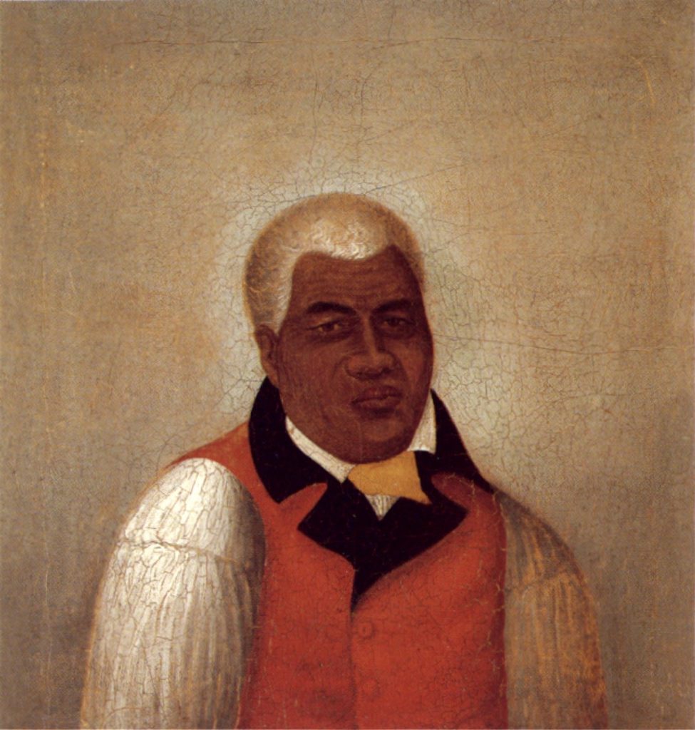
It has become a model for modern human rights law regarding the treatment of civilians and other non-combatants.  Kānāwai Māmalahoe appears as a symbol of crossed paddles in the center of the badge of the Honolulu Police Department.  The image shows Kamehameha as a young warrior (HerbKane.)

© 2023 Hoʻokuleana LLC


Filed Under: Ali'i / Chiefs / Governance Tagged With: Kamehameha, Kanawai Mamalahoe, Kahekili, Liholiho, Keoua, Kohala, North Kohala, Puukohola, Naha Stone, Hawaii, Kokoiki, Hawaii Island, Kekuiapoiwa, Hilo, Law of the Splintered Paddle

October 15, 2019 by Peter T Young Leave a Comment

Lapakahi State Historical Park

Lapakahi (“single ridge”) State Historical Park is the archaeological site of the remains of a traditional Hawaiian fishing community. It was believed to have been inhabited about 600-700-years ago (1300s.)

Lapakahi was a place of the maka‘āinana, the fishermen and farmers. They worked to sustain the resources and support their families.

The rolling hills and gulches sheltered this cove from the strong Kohala wind. The sea was rich in food and the soil nurtured their crops. Black stone walls and thatched roofs soon appeared on the landscape.

As the village prospered, the families moved inland to grow their crops of kalo (taro) and ‘uala (sweet potato). Families along the shore (makai) traded fish for kalo from the uplands (mauka).

Pa‘akai (“salt from the sea” – for seasoning and preservative for food) was taken mauka while olonā plants were brought makai to make nets and fishing line. A trail curbed with stones connected mauka and makai and the people of Lapakahi travelled this trail exchanging the resources of the land and sea.

Parts of this former village have been partially restored but most of the rocky walls and remains are original. Today, this 265-acre State Park is the site of an ancient Hawaiian settlement located along the shoreline of the North Kohala coastline.

A self-guided tour takes visitors over marked trails (with a free guide brochure) and leads them through several acres of this historic village.

Highlighted sites include house sites and a canoe halau (long house); runs through a game area where visitors can try spear throwing, ‘ulu maika (disc rolling) and konane (checkers); and leads to a fishing shrine and salt pans along the rocky shoreline.

Lava stone walls formed the lower portion of the homes and shelters built here. Wooden poles supported the pili grass roofs and walls. Trees, bushes, grass and rocks were all used as food sources or utensils for building, cooking or fishing.

In 1979, the nearshore waters were added to the Marine Life Conservation District (MLCD) system under DLNR. Within Koaiʻe Cove are two small beaches consisting of coral rubble (there is no sand beach). The cove provides the easiest access to the water.

The nearshore bottom is mostly boulders and lava fingers with some coral. The cove’s northern portion has some good coral growth close to shore, but coral and fish are most abundant in the southern portion. Considerable marine life is also found around the outcropping of rocks to the right of the cove’s center.

There is a remarkable diversity of fish species within the MLCD, as nearly all nearshore species typical of the North Kohala coast are represented. During the winter, humpback whales are frequently spotted just offshore.

Near the entrance to the park is an educational display of implements used by the ancient villagers. Pick up the guide brochure and take the self-guided tour through the marked trails at your convenience.

The Park is located on the northwestern coast of Hawaiʻi; Lapakahi is about 12 miles north of Kawaihae. Take Hwy 270 north from Kawaihae to Lapakahi State Historical Park. The park entrance is on the left side of the highway, and marked with a sign. Parking is available at the end of the road. (Lots of information here from DLNR.)

Follow Peter T Young on Facebook 

Follow Peter T Young on Google+ 

Follow Peter T Young on LinkedIn 

Follow Peter T Young on Blogger

© 2019 Hoʻokuleana LLC

Lapakahi State Park (pohaku)
Lapakahi State Park-entrance sign
Lapakahi State Park-sign
Lapakahi_beach
Lapakahi_coastal_area
Lapakahi-state-historical-park
Lapakahi-village-coastal-area
looking-over-lapakahi-village-kohala-coast
Reconstructed hale (house) at the village of Lapakahi
Lapakahi-GoogleEarth
Lapakahi-map
Lapakahi State Park-Brochure-noting_sites_and_uses

Filed Under: Hawaiian Traditions, Place Names Tagged With: Hawaii, Kohala, North Kohala, Lapakahi

April 26, 2019 by Peter T Young 1 Comment

Bond Historic District

The Bond Historic District is in the rural, agricultural area south of the town of Kapaʻau, North Kohala, on the Island of Hawaiʻi.

The buildings are grouped in three sections – The Bond Homestead (established in 1841 by Boston missionary Reverend Elias Bond,) Kalāhikiola Church (completed in 1855) and Kohala Seminary (Kohala Girl’s School – complex founded in 1872.)

The Reverend and Mrs. Bond sailed with the Ninth Company of Missionaries from Boston and settled at Kohala, Hawai‘i. Bond arrived in Honolulu in May of 1841. They were then assigned to Kohala.

Reverend Isaac Bliss, an elderly missionary in Kohala, had already completed the main house of what is known as the Bond Homestead compound when Bond arrived in Kohala in June 1841.

To provide employment to the people in the region and support his church and schools, Reverend Bond founded Kohala Sugar Company, known as “The Missionary Plantation,” in 1862.

Reportedly, by 1885, Bond, who gave all his dividends and profits beyond his living expenses to the Board of Missions, was their largest single contributor. The plantation was shut down in 1973.

The heart of the Bond District is the Bond Homestead located in makai portion of the property. The Homestead consists of two residential buildings, one doctor’s office and several out buildings. The buildings contain many historic furnishings and artifacts dating from 1844.

The area is described in an 1849 account (in ‘The Island World of the Pacific’) as follows: “It stands in the center of an area of some five or six acres, enclose with a neat stone wall, and having a part of it cultivated as a garden, adorned with flowering shrubs and trees, as the pineapple, guava, acacia, mimosa, tamarind, kukui, mulberry, geranium, banana, Pride of China, sugar cane, etc.”

“The house is thatched with long leaves of the hala-tree (Pandanus), and has a very pretty, neat appearance, in connection with that tasteful keeping of the walks and grounds, like the pictures we have of thatched cottages and rural scenes of Old England.”

Kalāhikiola Church is located on a gently sloping site in the middle section of the property. The structure was a rectangular building made of lava rock walls.

Kalāhikiola (“the life-bringing sun” or “the day bringing salvation”) is the name of a small hill on the side of the Kohala Mountain; the name goes back to the time of the arrival of the first Christian missionaries. ‘Ōhi‘a timbers from forests on the hill were used in building the church; so when the church was consecrated on October 11, 1855 it was appropriately given the name Kalāhikiola.

In 2006, an earthquake severely damaged the building. In the restoration, the congregation decided to remove the stone walls entirely, shore and brace the building, and erect new walls of reinforced concrete, which was then plastered and scored with mortar lines to resemble the church’s original exterior.

The Kohala Girl’s School was Reverend Bond’s last major undertaking. For 30-years prior to the 1874 founding of the Kohala Girl’s School, Reverend Bond ran a boarding school for boys. His decision to build a separate facility to educate native Hawaiian women in Christian living and housekeeping was made in 1872.

The Kohala Seminary (Kohala Girl’s School) is located mauka of Kalāhikiola Church; it consists of six wood frame buildings scattered over approximately 3 acres.

The main residence building is a generally rectangular two-and-one-half story structure; the building was constructed in 1874 and was used as dormitory and classroom space. In 1955, the school stopped functioning.

In addition to the missionary work and founding and operating the school, the Bonds had 11-children born in Hawai‘i.

The District is listed on both the State of Hawai’i and the National Registers of Historic Places.

Many years ago, I had the good fortune to have been able to tour the Bond Homestead with Lyman Bond, great grandson of Reverend Elias Bond. It was a wonderful experience to have a descendent relate stories of the people and the place.

My brother-in-law, Paul Morgan, while studying architecture, did extensive review of the Kohala Girls School structures; he gave me a tour of the Girls School.

New Moon Foundation acquired acreage in and around the Bond Historic District. The purchase agreement included covenants specifying that real property located in the Bond Homestead is of historic significance and should be preserved and protected.

The buildings have been restored and put into education adaptive reuse; the site is now known as the Grace Center of the Kohala Institute at ‘Iole. Kohala Institute’s effort in restoring Grace Center was recognized by the Historic Hawai‘i Foundation with a 2017 Historic Preservation Honor Award.

Follow Peter T Young on Facebook 

Follow Peter T Young on Google+ 

Follow Peter T Young on LinkedIn  

Follow Peter T Young on Blogger

© 2019 Hoʻokuleana LLC

Kohala_girls'_seminary-late-19th_century
Kohala_girls’_seminary-late-19th_century
Elias_Bond,_1883
Elias_Bond,_1883
Grace Institute at Iole
Kohala_Seminary_1907
A Kohala Seminary student poses with her ukulele in this 1912 photo
Restored_Dormitory_at_Kohala_Girls_School-(newmoonfoundation-org)
Restored_Building_at_Kohala_Girls_School-(newmoonfoundation-org)
Kalahikiola_Church-late-19th_century
Damage to Kalahikiola Church in 2006 earthquake
Kalahikiola_Church-damaged-USGS
Restoring_Kalahikiola_Church-(MasonArchitects)
Kalahikiola Church-after restoration-(MasonArchitects)
Bond_House,_19th_century
Bond-Homestead-(newmoonfoundation-org)
Bond_Homestead-(newmoonfoundation-org)
Bond_Historic_District-Layout-Map
Bond_Historic_District-Girls_School_Layout-Map
Bond_Historic_District-Kalahikiola_Church_Layout-Map
Bond_Historic_District-Homestead_Layout-Map
Bond_Historic_District-entrance-signs

Filed Under: Buildings, Missionaries / Churches / Religious Buildings Tagged With: Missionaries, Kohala, North Kohala, Elias Bond, Seminary, Kohala Sugar, Kalahikiola Church, Bond Historic District, Kohala Seminary, Kohala Girls School, Hawaii

  • 1
  • 2
  • Next Page »

Images of Old Hawaiʻi

People, places, and events in Hawaiʻi’s past come alive through text and media in “Images of Old Hawaiʻi.” These posts are informal historic summaries presented for personal, non-commercial, and educational purposes.

Info@Hookuleana.com

Connect with Us

  • Email
  • Facebook
  • LinkedIn
  • Twitter
  • YouTube

Recent Posts

  • Women Warriors
  • Rainbow Plan
  • “Pele’s Grandson”
  • Bahá’í
  • Carriage to Horseless Carriage
  • Fire
  • Ka‘anapali Out Station

Categories

  • Hawaiian Traditions
  • Military
  • Place Names
  • Prominent People
  • Schools
  • Sailing, Shipping & Shipwrecks
  • Economy
  • Voyage of the Thaddeus
  • Mayflower Summaries
  • American Revolution
  • General
  • Ali'i / Chiefs / Governance
  • Buildings
  • Missionaries / Churches / Religious Buildings

Tags

Albatross Al Capone Ane Keohokalole Archibald Campbell Bernice Pauahi Bishop Charles Reed Bishop Downtown Honolulu Eruption Founder's Day George Patton Great Wall of Kuakini Green Sea Turtle Hawaii Hawaii Island Hermes Hilo Holoikauaua Honolulu Isaac Davis James Robinson Kamae Kamaeokalani Kamanawa Kameeiamoku Kamehameha Schools Lalani Village Lava Flow Lelia Byrd Liliuokalani Mao Math Mauna Loa Midway Monk Seal Northwestern Hawaiian Islands Oahu Papahanaumokuakea Marine National Monument Pearl Pualani Mossman Queen Liliuokalani Thomas Jaggar Volcano Waikiki Wake Wisdom

Hoʻokuleana LLC

Hoʻokuleana LLC is a Planning and Consulting firm assisting property owners with Land Use Planning efforts, including Environmental Review, Entitlement Process, Permitting, Community Outreach, etc. We are uniquely positioned to assist you in a variety of needs.

Info@Hookuleana.com

Copyright © 2012-2024 Peter T Young, Hoʻokuleana LLC


Loading Comments...