“Ethnobotanical surveys provide evidence of extensive alteration of coastal and lower montane ecological zones and indicate that the entire area of East Maui from Ke‘anae to Kaupo was densely steeled prior to European contact.” (Cusick)
“[R]esearchers agree that Kipahulu and its neighbors, Hana to the northeast and Kaupo to the southwest were historically important relative to other districts in the Hawaiian Islands because of their abundant natural and human resources”. (Cusick)
“They were coveted lands, prized by the ali’i (nobility) for their abundance of foodstuffs and all the valued products of the land and sea. Plentiful food and resources made possible a large population, and many followers meant power of the chief controlling the land.” (Cusick)
The southeastern section of the island of Maui, comprising the districts of Hāna, Kīpahulu, Kaupo and Kahikinui, was at one time a Royal Center and central point of kingly and priestly power – Piʻilani ruled from here (he built Hale O Piʻilani – near Hāna.) This section of the island was also prominent in the later reign of Kekaulike.
Royal Centers were where the aliʻi resided; aliʻi often moved between several residences throughout the year. The Royal Centers were selected for their abundance of resources and recreation opportunities, with good surfing and canoe-landing sites being favored.
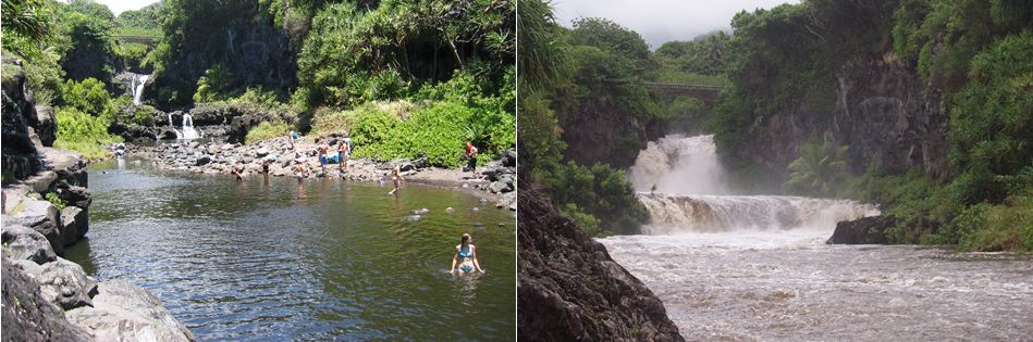
Long before the first Europeans arrived on Maui, Kīpahulu was prized by the Hawaiian aliʻi for its fertile land and abundant ocean. The first written description of the region was made by La Pérouse in 1786 while sailing along the southeast coast of Maui in search of a place to drop anchor:
“I coasted along its shore at a distance of a league (three miles) …. The aspect of the island of Mowee was delightful. We beheld water falling in cascades from the mountains, and running in streams to the sea, after having watered the habitations of the natives …”
“… which are so numerous that a space of three or four leagues (9 – 12 miles, about the distance from Hāna to Kaupō) may be taken for a single village.” (La Pérouse, 1786; Bushnell)
“But all the huts are on the seacoast, and the mountains are so near, that the habitable part of the island appeared to be less than half a league in depth. The trees which crowned the mountains, and the verdure of the banana plants that surrounded the habitations, produced inexpressible charms to our senses…”
“… but the sea beat upon the coast with the utmost violence, and kept us in the situation of Tantalus, desiring and devouring with our eyes what it was impossible for us to attain … After passing Kaupō no more waterfalls are seen, and villages are fewer.” (La Pérouse, 1786; Bushnell)
With the development of the whaling industry on the island in 1880s the southeastern Maui population started to decline as people moved to main whaling ports, such as Lāhainā. In the early-1900s, one of the regular ports of call for the Inter-Island Steam Navigation Company was at Kīpahulu. Steamships provided passenger service around Maui and between the islands.
“As long as Hawaii has been inhabited, there has been intercourse between the Islands. Before the white man came, and for some years after, the mode of travel was by outrigger canoe. Kamehameha I transported whole armies by this method while engaged in his campaign of conquest of the Islands.”
“The white man introduced the sailing schooner as a means of travel which continued in vogue until the middle of the eighteenth century, at which time the time the first steamship was placed in inter-island service.”
As the needs of transportation between the Islands grew, more steamships were brought over from the Mainland. By 1900 there were two fleets of ships in inter-island service: one operated by the Wilder Steamship Company and the other by the Inter-Island Steam Navigation Company.
“When these, two companies amalgamated in 1904 as the Inter-Island Steam Navigation Company the combined fleet totaled 14 vessels”. (Progress Report (1939) – Transportation)
“The Kaupo residents are delighted with the wharf and approach just completed at Mokulau. The approach just built may be driven over by a light wagon while the old route was such that the landing could only be reached by footmen or by pack animals.” (Maui News, Dec 8, 1906)
Also known as Kaupo Landing, “the best landing place in the vicinity during trade-wind weather. The local steamer visits this place occasionally”. (Hawaiian Place Names)
“At 9:15 a.m., we arrived at Mokulau. It is a small place. There is only one building, a storehouse. The wharf is a tall rocky hill. The storehouse and around it were full of men and women. We met with friends and acquaintances.”
“At 9:50 a.m., the Kilauea anchored. When the cargo and lumber were unloaded, the passengers were called. We gave our final farewell to Joseph Marciel, Mrs. Marciel and friends and got on the final rowboat. The Kilauea left Mokulau at 12:30 p.m.” (KaupoMaui)