Images of Old Hawaiʻi

  • Home
  • About
  • Categories
    • Ali’i / Chiefs / Governance
    • American Protestant Mission
    • Buildings
    • Collections
    • Economy
    • Missionaries / Churches / Religious Buildings
    • General
    • Hawaiian Traditions
    • Other Summaries
    • Mayflower Summaries
    • Mayflower Full Summaries
    • Military
    • Place Names
    • Prominent People
    • Schools
    • Sailing, Shipping & Shipwrecks
    • Voyage of the Thaddeus
  • Collections
  • Contact
  • Follow

August 6, 2022 by Peter T Young 1 Comment

Hui Kawaihau

When Kalākaua ascended to the throne in 1874, he named his youngest brother, William P Leleiōhoku, the heir apparent.

Leleiōhoku was educated at Saint Alban’s College (forerunner to ʻIolani School.)  An accomplished musician, he founded several choral societies. One of them was called Hui Kawaihau.

The Hui Kawaihau name was based on a nickname for an American missionary woman in town who preferred iced water (‘Kawaihau’) over some of the alcoholic libations the others were enjoying.

Leleiōhoku composed several songs, including, Adios Ke Aloha, Aloha No Wau I Ko Maka, Nani Wali Līhuʻe, Moani Ke Ala, Ke Kaʻupu, He Inoa No Kaʻiulani (a different song from the one with the same name by Liliʻuokalani), Nani Waipiʻo, Hole Waimea (this one was co-written with his singing club.)

He also wrote Kaua I Ka Huahuaʻi (Johnny Noble adapted most of the melody and kept most of the same lyrics of this one, and changed the spelling of the title, for his 1926 song Hawaiian War Chant (Taua I Ta Huahuaʻi.))

The Hui Kawaihau choral group had about fifteen members; it was more social than business.  When Leleiōhoku died in 1877, King Kalākaua reorganized the Hui into a business group.

Among the twelve hui charter organizers were some well-known names, including King Kalākaua; Governor Dominis, the King’s brother-in-law; Colonel George W. Macfarlane; Captain James Makee; Col. Curtis P. ʻIaukea; Governor John M. Kapena of the Island of Oahu; J. S. Walker and C. H. Judd; and Koakanu, a high chief of Kōloa, on Kauaʻi.

Their first order of business was to sign on more members and contract for the cultivation of sugar cane on land in Kapaʻa, on Kauaʻi.

The twelve organizers signed up thirty-two resident members.  About the first of August, 1877, the members of the Hui – over twenty men, with about the same number of women and children – set out from Honolulu, on the steamer “Kilauea,” on the voyage to their new home on Kauaʻi.

At the time, the districts of Hanalei and Līhuʻe shared a common boundary.  Kawaihau was set apart by the King, who gave that name to the property lying between the Wailua River and Moloaʻa Valley.  A bill was introduced into the legislature and the eastern end of Hanalei District was cut out and Kawaihau became the fifth district on the island of Kauaʻi.

About the time the Hui was started, Captain James Makee obtained a concession from the King to build a sugar mill at Kapaʻa and establish a plantation there.  He was the first manager of the Plantation, and had agreed with Kalākaua to grind in his mill all the cane grown by the Hui.

The contract with the Makee Sugar Company (under which each members of the Hui who came to Kauaʻi had signed separately with the plantation) required each of them to plant two hundred and forty acres of cane the first year, and they were to receive, in payment for their cane, two-fifths of the returns from the sale of the sugar obtained from it.

Each planter was required to plow his own portion of the tract and to buy his own seed-cane for planting.  A portion of the seed cane came from the neighboring Līhuʻe Plantation, ten miles to the south, and the balance they brought from Lāhainā.

Upon Makee’s death in 1878, his son-in-law, Col. ZS Spalding took over management of the new sugar venture.  Spalding also started the neighboring Keālia Sugar Plantation.  In the 1880s, Spalding built the “Valley House,” a Victorian-style wooden mansion, one of the finest on the island.

From 1877 to 1881, Hui Kawaihau was one of the leading entities on the eastern side of the Island of Kauaʻi, growing sugar at Kapahi, on the plateau lands above Kapaʻa.

As part of the infrastructure of the new plantation, the Makee Landing was built in Kapaʻa during the early years of the Makee Sugar Plantation.   Today, in place of the old Makee Landing, a breakwater is located on the north side of Mōʻīkeha Canal.

The Hui members all worked their share of the plantation – cultivating, irrigating and weeding the sugar cane under their supervision.  But they were all new to the business of growing cane – being mostly city men from Honolulu – all clerks and office men, etc.

The first crop was quite successful, netting the Hui over $17,000, from which was deducted the expense paid by the King for the Hui’s transportation to Kauaʻi, and the preliminary operations there – about $5000, which left enough to pay the members nearly $500 apiece, after paying the expenses.

In spite of the successful opening of the enterprise, it soon encountered dark days.  For nearly four years, troubles were increasing.

Colonel Spalding advised them to sell out to the Plantation, and thus end all their troubles; but they would not agree.

By 1881, four years after the favorable opening of the Hui’s plantation efforts, the members, disheartened and discouraged, had all drifted away, their property and leasehold rights, etc., passing into the hands of Colonel Spalding, the successor of Captain Makee as the head and principal owner of the Makee Sugar Company.

The Hui Kawaihau of Kauaʻi had passed into history.

In 1933, the Līhuʻe Plantation Co. purchased all of the outstanding Makee Sugar Co. stock and in the next year the mill was dismantled and combined with the Līhuʻe factory.  (Lots of information here from “The Hui Kawaihau” by Charles S Dole and The Friend, April, 1920.)

© 2022 Hoʻokuleana LLC

Filed Under: General, Economy, Place Names Tagged With: Kalakaua, Sugar, Kauai, Leleiohoku, Lihue Plantation, James Makee, Kapaa, Kawaihau, Hawaii

May 21, 2022 by Peter T Young 1 Comment

Haraguchi Rice Mill

The Royal Hawaiian Agricultural Society was formed in 1850 to develop Hawaiʻi’s agricultural resources.  It was then that rice made its mark in the Hawaiʻi economy. The group purchased land in the Nuʻuanu Valley and rice seed from China and planted in a former taro patch.

At first the Society offered the rice seed to anyone in Hawaiʻi who wanted to plant it. King Kamehameha IV also offered land grants for cultivation of rice.  Because there were no proper milling facilities in Hawaiʻi, it didn’t take off as a viable crop right away.

Then, in 1860, imported rice seed from South Carolina proved very successful and yielded a fair amount of crop.  This, combined with the collapse of the taro industry in 1861-1862 (as the Hawaiian population declined, the demand for taro also declined,) added value to the numerous vacant taro patches and a boom in the rice industry.

In 1899, Hawaiʻi’s rice production had expanded so that it placed third in production of rice behind Louisiana and South Carolina.

The Agricultural Extension Service of the University of Hawaiʻi encouraged rice production, primarily in Hanalei.  As a result the acreage planted in rice on the island rose from 759 acres in 1933 to 1,058 in 1934.

For areas like Hanalei Valley, such efforts, coupled with the valley’s general remoteness and absence of competing demands for the land, allowed rice cultivation to continue as a regional activity.

The Hanalei Valley of Kauaʻi led all other single geographic units in the amount of acreage planted in rice. The valley was one of the first areas converted to this use and continued to produce well into the 1960s.

The Commercial Pacific Advertiser noted on October 3, 1861, “Everybody and his wife (including defunct government employees) are into rice – sugar is nowhere and cotton is no longer king. Taro patches are held at fabulous valuations, and among the thoughtful the query is being propounded, where is our taro to come from?”

When the Japanese immigrants arrived in Hawaiʻi, their tastes preferred a shorter grain rice than the Chinese long-grain variety. With the decline of the Chinese population and increase in the Japanese population, more of the Japanese rice was being imported from Japan.

As the Japanese left the plantations, they started their own farms and cultivated their own staple rice.

It was at Hanalei where some Chinese built a rice processing facility; it as later purchased by the Haraguchi family in 1924.  At one time, the Haraguchis cultivated about 75-acres in Hanalei Valley.

Fire destroyed the original wooden mill in March of 1930; a new mill consisted of a 3-foot thick concrete foundation with corrugated iron for its roof and siding.  Interior spaces included engine room, milling area, and storage area for both finished and unprocessed rice.

This main engine operated all the mill machinery by turning a main shaft that connected all the other machines by a pulley system.  The rice in a pit would be delivered up by cups on a belt located on a “triple chute” system. One chute served the belts going downward, another chute for the belts returning upwards and a third to suck the dust up which traveled to the blower.

The cups carried the rice over the wall onto another chute and into the strainer. This strainer would shake the rice and separate any rubbish or stones to prevent it from entering the husking machines.  From the strainer, the rice would proceed to the first husker that removed part of the husk.

About 80% of the husks would be removed by this husker. The husks would travel up the air ‘chute to the blower which blew the husks out the back of the mill into a ditch that carried the husks into the river.

The partly husked rice would exit the first husker and was taken up a chute by belted cups and dropped onto another chute into the second husker. The second husker would remove the rest of the husks and the grains would continue up another “triple chute” which would carry it up and over into the polishing machine.

The fine dust from the second husker was collected in a basket under the machine and also taken up the chute into the blower.  Cowhide was used to polish the rice which prevented the grains from cracking which ensured high quality rice.  The rice would exit the polisher and taken up another chute to the grader.

The grading machine constantly shook to move the rice to the three different grades of rice. The whole grain would bypass the grading holes and a trowel was used to push the rice onto a small trough into the rice bag which hung at the end of the funnel.  From there the bags were scaled, sewn by hand and then stacked.

Despite the competition from the California grown rice, the Japanese farmers continued to produce on a smaller scale than the Chinese farmers. By the early 1950s there were about 50 growers cultivating 170 acres of rice on Kauaʻi. Hanalei Valley held 90 acres, 48 acres in Wailua and the rest was split between Hanapepe and Waimea valleys.

In addition to the staple rice, “mochi rice,” used for traditional Japanese cake on New Year’s and other special occasions, was grown.

The mochi rice from Hanalei Valley was noted for its quality throughout the Islands. It was largely a luxury crop and most of it was consumed in the Islands; about 200-bags were shipped to the Mainland.

Some mochi rice was imported from the Mainland but local buyers preferred the local crop since it was said to produce a larger yield of mochi per pound.

In 1959, Hurricane Dot left the mill intact except for an air vent at the roof peak that was torn off and not replaced.  The mill ceased operating in 1960 when Kaua`i’s rice industry collapsed. Hurricane Iwa on November 23, 1982 toppled 85% of the building onto the machinery; then came Hurricane Iniki in 1992.

The Haraguchi Rice Mill was the last mill to operate in Hanalei Valley and the only remaining rice mill in the State of Hawaiʻi.  A nonprofit organization was formed to preserve and interpret the mill; the organization is guided by an unpaid Board of Directors (many of them are members of the Haraguchi family.)  The Haraguchi family now farms taro on the adjacent lands that once supported rice.

Today, the Hoʻopulapula Haraguchi Rice Mill is an agrarian museum located in the taro fields of Hanalei Valley.  The Rice Mill Kiosk is open to the public, Monday through Saturday, 11 am – 3 pm.  No Public access into the farm & Rice Mill unless through guided tours, available Wednesdays at 10 am (reservations are required.)  (Lots of information here from NPS.)

© 2022 Hoʻokuleana LLC

Filed Under: General, Economy Tagged With: Hawaii, Japanese, Kauai, Rice, Royal Hawaiian Agricultural Society, Haraguchi Rice Mill, Chinese, Hanalei

May 1, 2022 by Peter T Young 4 Comments

May Day

May 1 is a special day in many cultures. The Celts and Saxons and others in pre-Christian Europe celebrated the first planting and the beauty of spring.

These agrarian celebrations continued down through the centuries and remain today. In much of Europe, May 1 is also a labor holiday, honoring the labor workers. (Akaka)

The first of May, however, has a unique and very special significance to the people of Hawaiʻi. May Day is Lei Day in Hawaiʻi. (Akaka)

Lei making in Hawaiʻi begins with the arrival of the Polynesians. Polynesians, across the South Pacific, adorned their bodies with strings of flowers and vines.

When they arrived in Hawai`i, in addition to the useful plants they brought for food, medicine and building, they also brought plants with flowers used for decoration and adornment.

Lei throughout Polynesia were generally similar. Types included temporary fragrant lei such as maile and hala, as well as non-perishable lei like lei niho palaoa (whale or walrus bone), lei pupu (shell) and lei hulu manu (feather.)

“The leis of Old Hawaii were made of both semi-permanent materials – hair, bone, ivory, seeds, teeth, feathers, and shells; and the traditional flower and leaf leis – twined vines, seaweed and leaf stems, woven and twisted leaves, strung and bound flowers of every description.”

“Leis were symbols of love, of a spiritual meaning or connection, of healing, and of respect. There are many references to leis, or as the circle of a lei, being symbolic of the circle of a family, embracing, or love itself: “Like a living first-born child is love, A lei constantly desired and worn.” (Na Mele Welo, Songs of Our Heritage, (translated by Mary Kawena Pukui,) Gecko Farms)

Robert Elwes, an artist who visited the Hawaiian islands in 1849, wrote that Hawaiian women “delight in flowers, and wear wreaths on their heads in the most beautiful way.”

“A lei is a garland of flowers joined together in a manner which can be worn. There are many different styles of lei made of numerous types of flowers. The type of flower used determines the manner in which the lei is woven.” (Akaka)

Reportedly, Don Blanding, writing in his book ‘Hula Moons,’ explained the origins of Lei Day: “Along in the latter part of 1927 I had an idea; not that that gave me a headache, but it seemed such a good one that I had to tell some one about it, so I told the editors of the Honolulu Star-Bulletin, the paper on which I worked.”

“They agreed that it was a good idea and that we ought to present it to the public, which we proceeded to do. It took hold at once and resulted in something decidedly beautiful.”

“… The custom of weaving and wearing flower leis originated with the Hawaiians so long ago that they have no record of its beginning. … When tourists discovered Hawaii, they loved the charming gesture and they spread the word of it until the lei became known around the world.”

“… Hawai`i observed all of the mainland holidays as well as those of a number of the immigrant nationalities in the Islands. But there was no day that was peculiarly and completely Hawaii’s own; that is none that included all of the polyglot population there.”

“So, the bright idea that I presented was, “Why not have a Lei Day?” Let everyone wear a lei and give a lei. Let it be a day of general rejoicing over the fact that one lived in a Paradise. Let it be a day for remembering old friends, renewing neglected contacts, with the slogan “Aloha,” allowing that flexible word to mean friendliness on that day.”

In 1929, Governor Farrington signed a Lei Day proclamation urging the citizens of Hawaiʻi to “observe the day and honor the traditions of Hawaii-nei by wearing and displaying lei.”‘ (Akaka) Lei Day celebrations continue today, marking May 1st with lei-making competitions, concerts, and the giving and receiving of lei among friends and family.

Reportedly, the “tradition” of giving a kiss with a lei dates back to World War II, when a USO entertainer, seeking a kiss from a handsome officer, claimed it was a Hawaiian custom.

In 2001, Hawaiʻi Senator, Dan Akaka, during a May 1 address, said, “’May Day is Lei Day’ in Hawaiʻi. Lei Day is a nonpolitical and nonpartisan celebration.”

“Indeed, its sole purpose is to engage in random acts of kindness and sharing, and to celebrate the Aloha spirit, that intangible, but palpable, essence which is best exemplified by the hospitality and inclusiveness exhibited by the Native Hawaiians — Hawaii’s indigenous peoples — to all people of goodwill.”

The lei of the eight major Hawaiian Islands become the theme for Hawai‘i May Day pageants and a lei queen chosen with a princess representing each of the islands, wearing lei fashioned with the island’s flower and color.

Hawai‘i – Color: ‘Ula‘ula (red) – Flower: ‘Ōhi‘a Lehua
Maui – Color: ‘Ākala (pink) – Flower: Lokelani
Kaho‘olawe -Color: Hinahina (silvery gray) – Flower: Hinahina
Lāna‘i – Color: ‘Alani (orange) – Flower: Kauna‘oa
Molokai – Color: ‘Ōma‘oma‘o (green) -Flower: Kukui
O‘ahu – Color: Pala luhiehu (golden yellow) or melemele (yellow) Flower: ‘Ilima
Kauai – Color: Poni (purple) – Flower: Mokihana
Ni‘ihau – Color: Ke‘oke‘o (white) – Flower: Pūpū (shell)

© 2022 Hoʻokuleana LLC

May Day
May Day
Lei_Sellers-(HSA)-PP-33-8-023-1901
Lei_Sellers-(HSA)-PP-33-8-018-1901
Lei_Maker-(HSA)-PP-33-8-004
Lei-sellers-seated-along-a-sidewalk-HHS-6055.jpg
Lei sellers displaying lei and flowers on sidewalk-(HSA)-PP-33-8-021
Lei sellers at the waterfront, Honolulu Harbor-(HSA)-PP-33-9-002
Lei sellers at the waterfront, Honolulu Harbor-(HSA)-PP-33-8-005
Lei sellers at entrance to the Bank of Hawaii, King and Bishop Sts-(HSA)-PP-33-8-022

Filed Under: Hawaiian Traditions, Economy, General Tagged With: May Day, Hawaii, Lei, Hawaii Island, Oahu, Molokai, Maui, Kauai, Lanai, Niihau, Kahoolawe, Lei Day

April 23, 2022 by Peter T Young 2 Comments

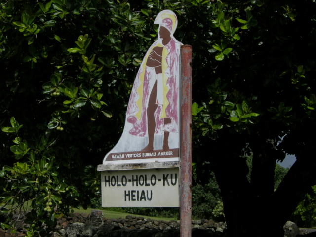
Holoholokū

Hānau ke aliʻi I loko o
Holoholokū, he aliʻi nui
Hānau ke kanaka I loko o
Holoholokū, he aliʻi no
Hānau ke aliʻi mawaho aʻe o H
Holoholokū ʻaʻohe aliʻi
he kanaka ia.

The child of a chief born in
Holoholokū is a high chief;
The child of a commoner born
in Holoholokū is a chief;
The child of a chief born outside
of the borders of Holoholokū
is a commoner.

The traditional name was Ka Lae o Ka Manu, which means the crest of the bird. Holoholokū appears to have been the ancient locality name.  (NPS)

Oral traditions tell of the sacred births of Kauaʻinui and Wailuanuihoʻano and the establishment of this area as a birthing site reserved for royalty. It is still considered as one of Hawaiʻi’s most sacred sites.  (Wailua Heritage Trail)

Holoholokū at Wailua on Kaua’i was one of two places in Hawai‘i specifically designated for the birth of high ranking children; the other site was Kūkaniloko near Wahiawa on Oʻahu.

Here all the kings of Kauaʻi were born, from earliest times to King Kaumualiʻi.  Aliʻi from other islands would also come here to give birth.

Kaumuali‘i was the only son of Kamakahelei and Kāʻeo (his mother Kamakahelei ruled the island when Captain James Cook made ‘contact’ in 1778.)  Kaumualiʻi was born the same year at Holoholokū. Kaumuali‘i became ruling chief of Kaua‘i upon the death of his parents.

It is said to be the oldest heiau on Kauaʻi and was named for a foster parent of Kawelo, son of Kauai’s ruling chief Mano-kalani-po and his wife Ka-wai-kini early in the 17th century.

Two boulders are within the heiau; the pōhaku hānau (birthstone) is actually two rocks.  Expectant mothers sat on the flat rock and rested her back on the other; when in use, the rocks were enclosed in a shelter and the rocks were covered with mats and kapa.

“… when an expectant mother of royal lineage was about to deliver her child, she would travel to the birthstone and squat on the ledge, leaning back against the upright section of the stone. After the birth, the mother and child were moved into a cave adjacent to the stone …“

“The mother remained in the cave with her child and retinue until she was able to travel; a booth or temporary shelter was built over the place. This was the sacred birthplace of the aliʻi or chiefs.”

“If the child really were a great chief, the heavens allegedly would burst forth with thunder and lightning, and there would be a heavy downpour of rain. A rainbow would arch over the area, with one end indicating the spot where the child had been born.”  (NPS)

A tradition describes how the piko (navel cord) of a newborn child was placed in the nearby Pōhaku Piko; if a rat stole the piko it was an omen that the child would grow up to be a thief, and allegedly the child was put to death. (NPS)

Another legend states that the newborn child was carried up a path to a boulder on the ridge, overlooking the river.  As the kahuna walked, he chanted of the arrival of the new chief.  (Joesting)

Within the walls of the heiau was a grass-thatched house of the kahuna.  “Bits of branch coral (indicative of sacredness) are scattered through the walls. Small, water-worn pebbles out on the earthen floor indicate the former presence of a house floor-pavement.”

“The west side of the heiau is bounded by a terrace and at the south end of this terrace, the south-west corner of the heiau, is a great horizontal ledge of stone, called the sacrificial stone.”

“Built out from the north side of this ledge is a little terrace, 9 feet square ….. I am certain the heiau of Ka-lae-o-ka-manu, or Holoholokū served in conjunction with the birth place, and that here the drum which would announce the news would be kept, as the drum of Kūkaniloko was kept in the near-by heiau.”  (Emery, 1933)

In December 1933, restoration of the Holoholokū heiau was completed by a team of volunteers led by Grove Farm director Henry Digby Sloggett, with Kapaʻa resident Charles Lono Kelekoma and Honolulu’s Bishop Museum providing technical expertise.   (TGI)

© 2022 Hoʻokuleana LLC

Filed Under: Ali'i / Chiefs / Governance, Hawaiian Traditions, Place Names Tagged With: Hawaii, Holoholoku, Kukaniloko, Kauai, Kamakahelei, Kaeo, Wailua, Kaumualii

April 8, 2022 by Peter T Young Leave a Comment

Island Summits

He ‘Ohu Ke Aloha; ‘A‘ohe Kuahiwi Kau ‘Ole
Love is like mist; there is no mountaintop that it does not settle upon

“… as the sun shining in his strength dissipated the clouds, we had a more impressive view of the stupendous pyramidal Mauna Kea, having a base of some thirty miles, and a height of nearly three miles.  Its several terminal peaks rise so near each other, as scarcely to be distinguished at a distance.”

“These, resting on the shoulders of this vast Atlas of the Pacific, prove their great elevation by having their bases environed with ice, and their summits covered with snow, in this tropical region, and heighten the grandeur and beauty of the scene, by exhibiting in miniature, a northern winter, in contrast with the perpetual summer of the temperate and torrid zones below the snow and ice.”

“The shores along this coast appeared very bold, rising almost perpendicularly, several hundred feet, being furrowed with many ravines and streams. From these bluffs, the country rises gradually, for a few miles, presenting a grassy appearance, with a sprinkling of trees and shrubs.”

“Then, midway from the sea to the summit of the mountain, appeared a dark forest, principally of the koa and ʻōhia, forming a sort of belt, some ten miles in breadth-the temperate zone of the mountain.”  (Bingham at first sight of the Islands, 1820)

And when you think about high elevation places in the Hawaiian islands, of course you have to talk about that basic dichotomy between the lower elevation places where people live.

And in old times, the lower elevations would have been called the Wao Kanaka. Wao being a word that means “zone” and “Kanaka” being a person. So the Wao Kanaka is a zone in which people belong.

When you rise above that zone, you enter into a realm in which all of the living things there are not there because of human activity. They flourish as the result of the activity of the gods, or the Akua. And so that zone is called the Wao Akua. And the transition from Wao Kanaka to Wao Akua is not taken lightly.  (Gon)

The Islands’ peaks are considered the piko (summit or center of the land) and are considered sacred.  The places upon which clouds nestle are considered wao akua, the realm of the gods.  Clouds cover the actions of the gods while they walk the earth. The higher the piko, the closer to heaven, and the greater the success of prayers. (Maly)

Let’s look at Hawaiʻi’s peaks, the highest point on each Island as we move down the Island chain.

Niʻihau – Pānīʻau (1,281-feet)

Ni‘ihau was formed from a single shield volcano approximately 4.89-million years ago, making it slightly younger in age than Kaua‘i. It is approximately 70-square miles or 44,800-acres.  It’s about 17-miles west of Kauaʻi.

Pānīʻau, the island’s highest point, is 1,281-feet; approximately 78% of the island is below 500-feet in elevation.   Located inside Kauai’s rain shadow, Ni‘ihau receives only about 20 to 40-inches of rain per year.  Ni‘ihau has no perennial streams.  (DLNR)

Kauai – Kawaikini (5,243-feet)

Geologically, Kauai is the oldest of the main inhabited islands in the chain. It is also the northwestern-most island, with Oʻahu separated by the Kaʻieʻie Channel, which is about 70-miles long. In centuries past, Kauai’s isolation from the other islands kept it safe from outside invasion and unwarranted conflict.

Near the summit (Kawaikini) is Waiʻaleʻale; in 1920 it passed Cherrapunji, a village in the Khasi hills of India, as the wettest spot on Earth (recording a yearly average of 476-inches of rain.)

Oʻahu – Kaʻala (4,025-feet)

The Waiʻanae Mountains, formed by volcanic eruptions nearly four-million years ago, have seen centuries of wind and rain, cutting huge valleys and sharp ridges into the extinct volcano.  Mount Kaʻala, the highest peak on the island of Oʻahu, rises to 4,025-feet.

Today, only a small remnant of the mountain’s original flat summit remains, surrounded by cliffs and narrow ridges. It’s often hidden by clouds.

Molokai – Kamakou (4,961-feet)

The island was formed by two volcanoes, East and West, emerging about 1.5-2-million years ago.  The cliffs on the north-eastern part of the island are the result of subsidence and the “Wailua Slump” (a giant submarine landslide – about 25-miles long that tumbled about 120-miles offshore – about 1.4-million years ago.)

Kamakou is part of the extinct East Molokai shield volcano, which comprises the east side of the island.   It and much of the surrounding area is part of the East Maui Watershed partnership and the Kamakou Preserve.  A boardwalk covers part of the rainforest and bog to protect the hundreds of native plants, birds, insects and other species there.

Lānai – Lānaihale (3,337-feet)

The island of Lānai was made by a single shield volcano between 1- and 1.5-million years ago, forming a classic example of a Hawaiian shield volcano with a gently sloping profile.  (SOEST)  The island of Lānai is about 13-miles long and 13-miles wide; with an overall land area of approximately 90,000-acres, it is the sixth largest of the eight major Hawaiian Islands.

“At the very summit of the island, which is generally shrouded in mist, we came upon what Gibson (an early (1861) Mormon missionary to the islands) called his lake – a little shallow pond, about the size of a dining table.  In the driest times there was always water here, and one of the regular summer duties of the Chinese cook was to take a pack mule and a couple of kegs and go up to the lake for water.”  (Lydgate, Thrum)

Maui – Haleakalā (10,023-feet)

Haleakalā was thought to have been known to the ancient Hawaiians by any one of five names: “Haleakalā,” “Haleokalā,” “Heleakalā,” “Aheleakalā” and “Halekalā.” (Hawaiʻi National Park Superintendent Monthly Report, December 1939)

Haleakalā is best known in stories related of the demi-god Māui; he is best known for his tricks and supernatural powers. In Hawaiʻi, he is best known for snaring the sun, lifting the sky, discovering the secrets of fire, fishing up the islands and so forth.  (Fredericksen)

Kahoʻolawe – Lua Makika (1,477-feet)

Kahoʻolawe is the smallest of the eight Main Hawaiian Islands, 11-miles long and 7-miles wide (approximately 28,800-acres;) it is seven miles southwest of Maui.  The highest point on Kahoʻolawe is the crater of Lua Makika at the summit of Puʻu Moaulanui, which is about 1,477 feet above sea level.

Located in the “rain shadow” of Maui’s Haleakalā, rainfall has been in short supply on Kahoʻolawe.  However, nineteenth century forestry reports mentioned a “dense forest” at the top of Kahoʻolawe.  Historically, a “cloud bridge” connected the island to the slopes of Haleakalā.  The Naulu winds brought the Naulu rains that are associated with Kahoʻolawe (a heavy mist and shower of fine rain that would cover the island.)

Hawaiʻi – Mauna Kea (13,796-feet)

Nani Wale ʻO Mauna Kea, Kuahiwi Kūhaʻo I Ka Mālie (Beautiful is Mauna Kea, standing alone in the calm) expresses the feeling that Mauna Kea is a source of awe and inspiration for the Hawaiian people. The mountain is a respected elder, a spiritual connection to one’s gods.   (Maly)

A significant pattern archaeologists note in their investigations is the virtual absence of archaeological sites at the very top of the mountain. McCoy states that the “top of the mountain was clearly a sacred precinct that must, moreover, have been under a kapu and accessible to only the highest chiefs or priests.”  (Maly)

ʻĀina mauna, or mountain lands, reflects a term used affectionately by elder Hawaiians to describe the upper regions of all mountain lands surrounding and including Mauna Kea.  (Maly)

© 2022 Hoʻokuleana LLC

Filed Under: Hawaiian Traditions, General Tagged With: Kaala, Kamakou, Hawaii, Kawaikini, Hawaii Island, Paniau, Oahu, Mauna Kea, Molokai, Lanaihale, Haleakala, Summits, Maui, Kahoolawe, Kauai, Lanai, Niihau

  • « Previous Page
  • 1
  • …
  • 6
  • 7
  • 8
  • 9
  • 10
  • …
  • 19
  • Next Page »

Images of Old Hawaiʻi

People, places, and events in Hawaiʻi’s past come alive through text and media in “Images of Old Hawaiʻi.” These posts are informal historic summaries presented for personal, non-commercial, and educational purposes.

Info@Hookuleana.com

Connect with Us

  • Email
  • Facebook
  • LinkedIn
  • Twitter
  • YouTube

Recent Posts

  • St Mary’s – St Joseph’s
  • Ka Nupepa Kuokoa
  • Aloha Tower
  • Standing Bear
  • 250 Years Ago … ‘United Colonies’ Becomes the ‘United States of America’
  • Nobuo Fujita
  • Labor Day

Categories

  • Missionaries / Churches / Religious Buildings
  • Hawaiian Traditions
  • Military
  • Place Names
  • Prominent People
  • Schools
  • Sailing, Shipping & Shipwrecks
  • Economy
  • Voyage of the Thaddeus
  • Mayflower Summaries
  • American Revolution
  • General
  • Ali'i / Chiefs / Governance
  • Buildings

Tags

Albatross Al Capone Ane Keohokalole Archibald Campbell Bernice Pauahi Bishop Charles Reed Bishop Downtown Honolulu Eruption Founder's Day George Patton Great Wall of Kuakini Green Sea Turtle Hawaii Hawaii Island Hermes Hilo Holoikauaua Honolulu Isaac Davis James Robinson Kamae Kamaeokalani Kameeiamoku Kamehameha Schools Lalani Village Lava Flow Lelia Byrd Liberty Ship Liliuokalani Mao Math Mauna Loa Midway Monk Seal Northwestern Hawaiian Islands Oahu Papahanaumokuakea Marine National Monument Pearl Pualani Mossman Quartette Thomas Jaggar Volcano Waikiki Wake Wisdom

Hoʻokuleana LLC

Hoʻokuleana LLC is a Planning and Consulting firm assisting property owners with Land Use Planning efforts, including Environmental Review, Entitlement Process, Permitting, Community Outreach, etc. We are uniquely positioned to assist you in a variety of needs.

Info@Hookuleana.com

Copyright © 2012-2024 Peter T Young, Hoʻokuleana LLC

Loading Comments...