“… at 5 o’clock we arrived there and saw a number of People, I believe between 2 and 300 … we still continued advancing, keeping prepared against an attack tho’ without intending to attack them … they fired one or two shots, upon which our Men without any orders rushed in upon them, fired and put ’em to flight; several of them were killed”. (Diary of Lt. John Barker, Library of Congress)
The first shot (“the shot heard round the world”) was fired just as the sun was rising at Lexington. The American militia were outnumbered and fell back; and the British regulars proceeded on to Concord.
On April 19, 1775, the Battles of Lexington and Concord were the first military engagements of the American Revolutionary War. The battles marked the outbreak of open armed conflict between the Kingdom of Great Britain and its thirteen colonies of British North America.
Following this, the Continental Congress adopted the Declaration of Independence and it was signed by 56-members of the Congress (1776.) The next eight years (1775-1783) war was waging on the eastern side of the continent. The main result was an American victory and European recognition of the independence of the United States.
The formal end of the war did not occur until the Treaty of Paris and the Treaties of Versailles were signed on September 3, 1783 and recognized the sovereignty of the United States over the territory bounded roughly by what is now Canada to the north, Florida to the south, and the Mississippi River to the west.
The treaty document was signed by John Adams, Benjamin Franklin and John Jay (representing the United States) and David Hartley (a member of the British Parliament representing the British Monarch, King George III.)
The last British troops left New York City on November 25, 1783, and the US Congress of the Confederation ratified the Paris treaty on January 14, 1784.
While the Colonists were battling the British, the Hawaiian Islands were divided into four chiefdoms: (1) the island of Hawaiʻi under the rule of Kalaniʻōpuʻu, who also had possession of the Hāna district of east Maui; (2) Maui (except the Hāna district,) Molokaʻi, Lānaʻi and Kahoʻolawe, ruled by Kahekili; (3) Oʻahu, under the rule of Kahahana; and at (4) Kauaʻi and Niʻihau, Kamakahelei was ruler.
Separate chiefdoms ruled separate parts of the Islands. However, conquest was in the air and battles and negotiations for power and control were going on.
In about 1781, through a well-planned campaign, Kahekili was able to regain possession of the Hāna district and this marked the beginning of the disintegration of Kalaniʻōpuʻu’s kingdom. (Kuykendall)
Kalaniʻōpuʻu died shortly thereafter (1782.) Before his death, Kalaniʻōpuʻu gave an injunction to Kiwalaʻo and Kamehameha, and to all the chiefs, thus: “Boys, listen, both of you. The heir to the kingdom of Hawaii nei, comprising the three divisions of land, Kaʻū, Kona and Kohala, shall be the chief Kiwalaʻo. He is the heir to the lands.” (Fornander)
“As regarding you, Kamehameha, there is no land or property for you; but your land and your endowment shall be the god Kaili (Kūkaʻilimoku.) If, during life, your lord should molest you, take possession of the kingdom; but if the molestation be on your part, you will be deprived of the god.” These words of Kalaniʻōpuʻu were fulfilled in the days of their youth, and his injunction was realized. (Fornander)
On Hawaiʻi Island, civil war broke out between Kīwalaʻō’s forces and the various chiefs under the leadership of Kamehameha. In the first major skirmish, the battle of Mokuʻōhai (a fight between Kamehameha and Kiwalaʻo in July, 1782 at Keʻei, south of Kealakekua Bay on the Island of Hawaiʻi,) Kiwalaʻo was killed.
The result of the battle of Mokuʻōhai was virtually to split the island of Hawaiʻi into three independent and hostile factions. The district of Kona, Kohala and portions of Hāmākua acknowledged Kamehameha as their sovereign. (Fornander)
The remaining portion of Hāmākua, the district of Hilo and a part of Puna, remained true to and acknowledged Keawemauhili as their Mōʻī; while the lower part of Puna and the district of Kaʻū, the patrimonial estate of Kīwalaʻō, ungrudgingly and cheerfully supported Keōua against the mounting ambition of Kamehameha. (Fornander)
On Maui, “At that time, Kahekili was plotting for the downfall of Kahahana and the seizure of Oʻahu and Molokaʻi, and the queen of Kauaʻi was disposed to assist him in these enterprises.” (Kalākaua)
Kahekili deceived Kahahana by having him believe Kaʻōpulupulu (his kahuna, priest) had offered the government and throne of Oʻahu to him (Kahekili), but that out of affection for his nephew he had refused; and he intimated strongly that Kaʻōpulupulu was a traitor to Kahahana.
Kahahana believed the falsehoods and it subsequently caused friction between Kahahana and Kaʻōpulupulu and the Oʻahu King turned a deaf ear to his kahuna’s advice and by the later part of 1782 or beginning of 1783, he arranged to have Kaʻōpulupulu killed.
Weakened, Kaʻōpulupulu commanded his wounded son, who had gained a point where a few steps would have placed him at the mercy of the angry sea: “E nui ke aho e kuʻu keiki a pa ke kino I ka ili kai a na ke kai ka ua ʻāina la” …
“Spend not your strength my son until your body strikes the surface of the ocean, for the land belongs to the sea.” This cryptic message culminated in the invasion of Oʻahu by Kahekili, aliʻi nui of Maui. (Nui; Cultural Surveys)
With his main obstacle removed, Kahekili prepared for an invasion against Oʻahu and Kahahana. He called on Kahahawai, his special friend, strategist and war chief. Kahekili’s warriors landed at Waikīkī in the beginning of 1783.
While Kahekili and his Maui army were camped near the heiau at ʻApuakehau, without authorization from Kahahana, the Eight of Oʻahu suddenly attacked the Maui warriors. The conflict was hand to hand, and in that respect was favorable to the eight men well-skilled in the use of spear and javelin.
Side by side, striking and smiting all before them, the little band forced its way into the heart of the body of its foes. It has been said that this was a fight “to which Hawaiian legends record no parallel.” Eight men attacked an army and for some time were victorious in their onslaught. (Westervelt)
Kahahana’s army was later routed, and he and his wife fled to the mountains. For nearly two years or more they wandered over the mountains, secretly aided, fed and clothed by his supporters. He was finally betrayed and killed by his wife’s brother. (Kanahele)
Kahekili and his eldest son and heir-apparent, Kalanikūpule, conquered Kahahana, adding Oʻahu under his control. (Kahekili’s son, Kalanikūpule, inherited his chiefdom; Oʻahu was later lost to Kamehameha in the Battle of Nuʻuanu (1795.))
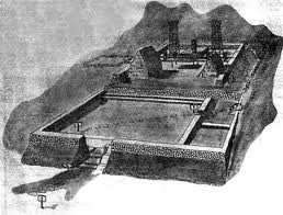
The image shows a Herb Kane depiction of the sea portion of the land-sea battle of Mokuʻōhai.
")