Images of Old Hawaiʻi

  • Home
  • About
  • Categories
    • Ali’i / Chiefs / Governance
    • American Protestant Mission
    • Buildings
    • Collections
    • Economy
    • Missionaries / Churches / Religious Buildings
    • General
    • Hawaiian Traditions
    • Other Summaries
    • Mayflower Summaries
    • Mayflower Full Summaries
    • Military
    • Place Names
    • Prominent People
    • Schools
    • Sailing, Shipping & Shipwrecks
    • Voyage of the Thaddeus
  • Collections
  • Contact
  • Follow

September 23, 2023 by Peter T Young 1 Comment

ʻĀina Haina (ʻIli of Wailupe)

Waikīkī (“water spurting from many sources”) ahupuaʻa lies between Honolulu (from the west side of Makiki Valley) and Maunalua (the east side of Wailupe) – essentially from Piʻikoi Street to the ʻĀina Haina/Niu Valley boundary.

It included several ʻili, subdivisions/portions of ahupuaʻa.  Wailupe is one of these ʻili; it is actually an ʻili lele (jumping ʻili) that includes the area we now call ʻĀina Haina and kalo (taro loʻi) lands in nearby Pālolo Valley.

From ancient times, we learn Wailupe is part of the tradition of Kamapuaʻa, a multi-formed deity.

The Hawaiian deity Kamapuaʻa, is a part of the Lono god-force, and possessed many body forms (kinolau), representing both human and various facets of nature. He was born in pig-form to Hina (mother) and Kahiki‘ula (father) at Kaluanui in the Koʻolauloa District of O‘ahu.  (Maly)

ʻOlopana, an Oʻahu Chief (and younger brother of Kahiki’ula,) was an adversary of Kamapuaʻa.  After several skirmishes and confrontations between them, Kamapuaʻa finally killed ʻOlopana and conquered Oʻahu.

When Kamapuaʻa started to divide the land, one of the notable aspects of the tradition of Kamapuaʻa is that, Lonoawohi, his priest, asked for and received the lands whose names begin with the word “wai” (i.e. Waikiki, Waianae, Waiawa … and Wailupe.  Thus, the priests of the Lono class received the “wai” lands.  (Maly)

In Hawai‘i and essentially in all cultures – water meant life and growth. In Hawai‘i – “Wai” – fresh water – is a life force – it meant abundance and wealth and was a consistent theme in native traditions, practices, land use and historical accounts.

Wailupe (literally, “kite water”) suggests this was one of the prescribed places to fly kites, some suggesting the land was named “for a kite-flying woman (he wāhine hoʻolele lupe.)”

Another name for the area was Kekaha (“the place”) and is noted in the names of the winds the canoes could expect while sailing along the southeast coast of Oʻahu:

Puuokona is of Kuliʻouʻou
Ma-ua is the wind of Niu
Holouhā is of Kekaha (Wailupe)
Māunuunu is of Wai‘alae
The wind of Lēʻahi turns here and there …

There are three gulches forming the valley; the main Wailupe Gulch follows the lower Wailupe Stream and a branch to the northwest. The northeast branch follows Laulaupoe Gulch, which is named for a round (poe) type of leaf package (laulau) used for food and for presentations.

Above, there is a third gulch called Kuluʻī, which is named for a type of tree/shrub.   On early maps, a second small stream is shown on the western side called Waialiʻi (probably “water of the chiefs.”)  (Cultural Surveys)

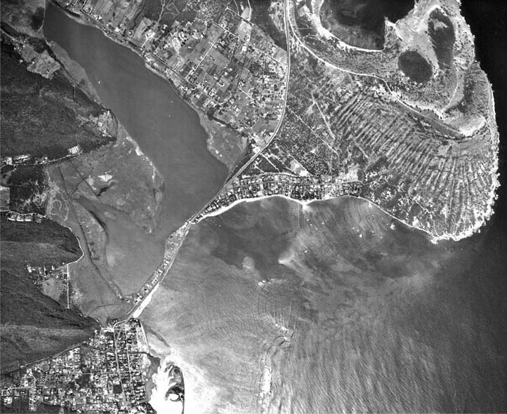
What we know today as Wailupe Peninsula is the former Wailupe Fishpond. The Hawaiian term for the pond was Loko Nui o Wailupe, “big pond of Wailupe.”

Just mauka of the fishpond (makai of the main coastal trail, now covered by Kalanianaʻole Highway) was a spring called Puhikani. There was a second spring, which fed a fishpond of the same name, on the west side of Wailupe Pond called Punakou, which means “kou tree spring.”

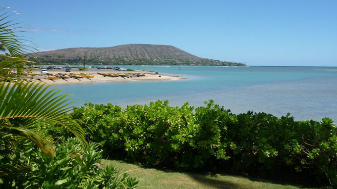
Kawaikuʻi Beach Park is named after a freshwater spring in this area that was the only source of drinking water for the coastal residents. Kawaikuʻi means “the united water” (named either because of the salt and fresh water “united” at the spring or because Wailupe residents once came to wash their clothes on flat rocks near the spring and to gather limu – thus the population congregated or “united” at this spot.)

In 1826, the missionary Levi Chamberlain took a tour of the island of O‘ahu, traveling through the southern coast of O‘ahu westward from Makapuʻu. He recorded a settlement of eighteen houses at Maunalua, with three additional settlements between Maunalua and Wai‘alae. These settlements were probably at Kuliʻouʻou, Niu and Wailupe. At Wai‘alae he stopped at a settlement with a schoolhouse.  (Cultural Surveys)

The land of Wailupe was reportedly distributed to the father of Kamaha by Kamehameha the Great following the Battle of Nuʻuanu in 1795.

At the Māhele, Kamaha, konohiki (land manager) of the land, received Wailupe, retaining half and returning half.  (The King accepted “the large Fish pond (Wailupe Pond) and one acre of Kula land in the Ili of ‘Wailupe’ Oʻahu;” Kamaha received the remainder of the land and all of the smaller fishponds.)  (Cultural Surveys)

In Wailupe, 57 claims were made and 37 were awarded, indicating that there was substantial settlement in the area. The claims were mainly for kula lands with sweet potato, coconut, orange, hala, ipu and pili grass with no mention of taro being grown. Lots averaged 1.5-acres with two kula patches. The majority of lots were adjacent to major streams within the valley.

In 1924, Robert Hind purchased 2,090-acres and established the Hind-Clarke Dairy.  The Hind-Clarke Dairy was a favored stop along the road, as noted in a 1930 visitor’s guide: “The Hind-Clarke Dairy, a short way ahead and to our left with a large sign over the entrance, is not to be passed unnoticed. The dairy is a model of its kind and well affords an opportunity to see dairying in its most scientific form. The cottage cheese on sale is, perhaps, the most delicious you have ever tasted.”  (Cultural Surveys)

In 1946, Hind sold his dairy operation to Creameries of America, and soon after that began to develop the remainder of his land for residential use.  The former cattle pasture was subdivided into lots to form a new residential community called ‘Āina Haina (which means, “Hind’s land.”)

Soon after this the Hawaiian Dredging Company filled in the old Wailupe Fishpond, forming the Wailupe Circle subdivision. A deep channel (depth of approximately 12 to 20 feet) was dredged around the pond, as well as a channel through the reef to the open ocean) and dredge material filled in the pond.

The ‘Āina Haina Shopping Center was built in 1950 (Hawaiʻi’s first McDonald’s opened there on November 2, 1968.)  (The Hind Clark Dairy operation occupied the area now used as ʻĀina Haina Shopping Center and ʻĀina Haina Elementary School.)  (Lots of information here from Maly and Cultural Surveys)

© 2023 Hoʻokuleana LLC

Filed Under: Place Names, Economy Tagged With: Wailupe, Hawaii, Waikiki, Oahu, Kamapuaa, Maunalua Bay, Maunalua, Hind, Dairymen's Association, Aina Haina

September 27, 2022 by Peter T Young 1 Comment

Kalauhaʻihaʻi Fishpond

In ancient Hawai‘i, fishponds were an integral part of the ahupua‘a.  Hawaiians built enclosures in near shore waters to raise fish for their communities and families.  It is believed these were first built around the fifteenth century.

A fish was kapu to the Hawaiians during its spawning season, to allow a variety of fish to reproduce. Although the chief or commoners were unable to catch fish in the sea at specific time spans, they were available in the fishponds because fishponds were considered a part of the land.

In 1848, when King Kamehameha III pronounced the Great Māhele, or land distribution, Hawaiian fishponds were considered private property.  This was confirmed in subsequent Court cases that noted “titles to fishponds are recognized to the same extent and in the same manner as rights recognized in fast land.”

Maunalua Bay, located at the southeast end of Oʻahu, was once home to many large Hawaiian fishponds; one of these was Kalauhaʻihaʻi fishpond (sometimes referenced as Kalauhaʻehaʻe (and Lucas Pond/Spring.))

Its original owners were King Kamehameha I and Queen Kaʻahumanu who maintained a summer residence on Paikō Beach.  Kalauhaʻihaʻi was once one of Oʻahu’s most thriving and productive fishponds, raising awa, aholehole, mullet and other favorites.

The name Kalauhaʻihaʻi refers to Queen Kaʻahumanu’s breaking of the old kapu (the ancient system of laws and regulations) when she became Christian, which is said to have taken place on the property.

King Kamehameha later gave the land, including the spring and pond, to Captain Alexander Adams (1780–1871.)  “Many were the self-sacrificing services rendered Kamehameha and Kaʻahumanu by Captain Adams, and they both loved him for his loyal devotion.”

“In appreciation they gave him the whole of the land of Niu, Oʻahu, and included also in this gift their favorite resort subsequently called Kalauhaihai, the place where Kaahumanu first proclaimed her renunciation of ancient rites and customs, to adopt modern civilization and customs.”

“That was why the place was so named, meaning a scattering or dropping off of leaves; plucking withered leaves, a renunciation of the ancient customs to adopt the new.”  (Thrum)

Ownership of the 2,446-acres were claimed by Alexander Adams under Claim No. 802 filed February 14, 1848, with the Land Commission at the time of the Great Māhele.

The claim states: “From the testimony of Governor Kekūanāoʻa … it appears that the claimant was created lord of konohiki of this land, in the time of Kamehameha I, and that he has exercised the konohikiship of the same without dispute ever since the year of Our Lord 1822.”

The Niu Valley estate was passed down to Adams’ granddaughter, Mary Lucas; Kalauhaʻihaʻi fishpond was later used for a family dairy by Mary Lucas.  She started subdividing the property in the 1950s; Adam’s descendants remain in the area.

In the 1960s, Mr. Tad Hara had a two-story wooden house built over the still productive pond.  The home was designed with a glass floor to allow Mr. Hara to view the fish in the pond.

The 3-foot-deep pond was filled with aholehole (Hawaiian flagtail,) ʻopae lolo (aloha prawn,)ʻamaʻama (mullet,) awa (milkfish,) hapawai (brackish water snail) and koi.  In 1989, Mr. Hara registered his fishpond with the State Water Commission.

Widening Kalanianaʻole Highway (the fourth busiest highway in the State) in the early-1990s changed things.

During construction, they ruptured the lava tube connecting Kalauhaʻihaʻi Fishpond to the underground artesian source directly mauka of the pond that altered spring flow to the ocean, diverted the water to utility line trenches and the sewer.

A legal battle ensued to restore the spring’s flow; Mr. Hara eventually sold the property to the DOT.

A community effort to preserve the pond resulted in a NOAA-sponsored plan and legislation to keep the property in state hands and away from public auction (as well as providing statewide preference for the reconstruction, restoration, repair, or use of Hawaiian fishponds.)

Since 2007, Maunalua Fishpond Heritage Center has been working to save Kalauhaʻihaʻi; they happily reported that on July 11, 2013, they were given the keys to the property and permission to restore the fishpond and care for the grounds.

In 2021, Maunalua Fishpond Heritage Center worked with the State Legislature to secure $1 million to go to DLNR Engineering Branch for the reconnection and long awaited repair of the water flow at Kalauhaʻihaʻi.

© 2022 Hoʻokuleana LLC

Filed Under: Hawaiian Traditions, Place Names Tagged With: Hawaii, Oahu, Alexander Adams, Maunalua Bay, Maunalua, Fishpond, Niu, Kalauhaihai Fishpond

November 6, 2021 by Peter T Young 1 Comment

Portlock

Recent work that I have been involved with in the Portlock area on O‘ahu, reminded me of the namesake for the place, explorer and fur trader Nathaniel Portlock.

Nathaniel Portlock was born in about 1748 in Norfolk, Virginia, where his grandfather had emigrated, probably from the English south-west, around 1685. Nathaniel’s father died in 1752, leaving his wife Rebecca (formerly Ballard, who had previously been a widow with a daughter from a previous marriage).

Nathaniel’s father’s will left his property, and stay and board, to “my Daughter in Law Nancey Ballard a Negro … said children [Paul and Nathaniel] [and] their mother”.

After Portlock’s father’s death, his mother Rebecca quickly remarried a third time to a Richard Scott, who became guardian to her three surviving Portlock children and had others with her.

At about the age of 24, Nathaniel Portlock entered the British Royal Navy and was one of the loyal colonists of America, known as the “American Loyalists;” he later left that country on the close of the War of Independence.

(It is not clear what relationship a certain John Portlock had with Nathaniel; but John was born in 1765 in Shenandoah Co., Virginia and in 1781 volunteered to serve in the Virginia Regiment and fought and was “slightly wounded’ in the American Revolutionary War. It is an interesting situation if they are related.)

On March 30, 1776, he served as master’s mate on Captain James Cook’s third Pacific voyage aboard the Discovery. Portlock was transferred to the Resolution, also on the expedition, in August 1779.

Cook’s third and final voyage (1776-1779) of discovery was an attempt to locate a North-West Passage, an ice-free sea route which linked the Atlantic to the Pacific Ocean. Cook commanded the Resolution while Charles Clerke commanded Discovery. (State Library, New South Wales)

“Cook had chosen his subordinates well or had been lucky. The officers of the third voyage were a remarkably intelligent group of men.” (Captain Cook Society)

“All the great remaining voyages of the eighteenth century drew on Cook’s officers. Bligh, Portlock, Vancouver, Colnett, Riou, and Hergest all got their commands and served with great distinction. These men then passed on their skills to a second generation of men such as Flinders and Broughton.” (Mackay, Captain Cook Society)

Nathaniel Portlock and George Dixon, observed the commercial benefits that the development of the fur trade in the region could bring. In 1785, a group of London merchants formed the “King George’s Sound Co” (also known as Richard Cadman Etches and Company).

They proposed to carrying on the fur trade from the western coast of America to China, bringing home cargoes of tea from Canton for the East India Company. They bought two boats; Portlock and Dixon were selected to sail them (Dixon also previously sailed with Cook to Hawai‘i) and they set off on an expedition to North America to establish a foothold for fur trappers.

Portlock commanded the 1785-1788 expedition from the ship King George, while Dixon captained the Queen Charlotte. The purpose of the expedition was to investigate the potential of the Alaskan fur trade and to resume Cook’s search for a Northwest Passage through the continent.

The pair left England on August 29, 1785, and took nearly a year to reach Alaska, rounding Cape Horn and touching at Hawaiʻi on the way, first arriving off the coast of Kaʻū, May 24, 1786.

These were the first English ships to reach Hawai‘i following Captain Cook’s first arrival there in 1778. During the course of their 3-year expedition, they made three trips to Hawaiʻi.

A favorite anchorage on Oʻahu for Portlock was at Maunalua Bay (which Portlock named King George’s Bay). He named the Waikiki area (Diamond Head to Honolulu) Queen Charlotte’s Bay.

The East point of the Maunalua Bay (Koko Head) Portlock named Point Dick, “in honour of Sir John Dick, the first patron of this voyage,”) and the West point (Diamond Head) that Portlock named “Point Rose, after George Rose Esq. secretary of the treasury, the second worthy patron of our undertaking.” (Portlock)

Portlock also mentioned what is probably Kuapā Pond that he described as, “a little salt water river that has a communication with King George’s Bay.”

Portlock wrote about the early challenges of getting fresh drinking water in the region as they “found that we could not water at this place without an infinite deal of trouble …”

“… besides the danger of losing our casks, getting the boats dashed to pieces against the rocks, and the inconvenience of carrying our casks so far amongst a multitude of Indians, which would make it necessary to have an armed force on shore.”

“Towards evening the surgeon returned on board with the convalescents, and informed me, that the inhabitants had behaved in a very quiet inoffensive manner, though they were rather incommoded by the multitudes which curiosity brought about them.”

“By this time all our water from the ground tier was got to hand, and the cables coiled down. The inhabitants now brought us water in such plenty, that by noon on the 4th all our empty casks were filled”.

He noted, “As good water in any quantity may be procured at this island with the greatest facility for small nails and buttons, it undoubtedly must be the safest and most expeditious method any person can adopt who may chance to touch here, to barter for their water in the manner we did.” (Portlock)

“No chiefs of consequence paid us a visit as yet: the inferior chiefs indeed came on board without any scruple, and some of them slept with us every night. Amongst rest I had a daily visit from an old priest, who always brought by way of present, a small pig, and a branch of the cocoa-nut·tree.” (Portlock)

Maunalua was thought to be well-populated in ancient times. Maunalua was known for its offshore fishing resources, a large fishpond, and sweet potato cultivation. Taro was farmed in wet areas, sweet potato was grown in the drier regions and a series of fishing villages lined the coast. (McElroy) Part of that area now carries the Portlock name.

© 2021 Hoʻokuleana LLC

Filed Under: Sailing, Shipping & Shipwrecks, Economy, Prominent People Tagged With: Hawaii, Kamehameha Schools, Oahu, Captain Cook, Leahi, Diamond Head, Maunalua Bay, Portlock, Nathaniel Portlock, Maunalua

July 5, 2019 by Peter T Young 2 Comments

Kuapā Pond

Kuapā Pond, also known as Keahupuaomaunalua (“the shrine of the baby mullet at Maunalua”) was once the largest loko kuapā on O‘ahu, estimated at approximately 523-acres.

Kuapā Pond was apparently created near the end of the ice age, when the rising sea level caused the shoreline to retreat and partial erosion of the headlands adjacent to the bay formed sediment that accreted to form a barrier beach at the mouth of the pond, creating a lagoon.

Early Hawaiians used the natural lagoon as a fishpond and reinforced the natural sandbar with stone walls.

Kuapā literally means “wall of a fish pond” and a loko kuapā is one type of fishpond made by building a wall on a reef.  The wall at this fishpond was about 5,000 feet long.

One of the main harvests was mullet because the combination of freshwater and shallow sand or mud flats that the ponds created were ideal for growing the algae that mullet fed off of.

Hawaiian Historian Kamakau writes of Kamehameha I participating in the restoration of the Maunalua fishpond., “While he (Kamehameha) lived on Oahu he encouraged the chiefs and commoners to raise food and he went fishing and would work himself at carrying rock or timber … He worked at the fishponds at Ka-wai-nui, Ka‘ele-pulu, Uko‘a (in Waialui,) Mauna-lua, and all about O’ahu.  (Kamakau 1961:192)

In 1900, the island of Oahu had a total of 100 documented, working fishponds, providing thousands of pounds of fish for the community throughout the year.

Missionary Levi Chamberlain, during his Trip Around Oahu on June 21, 1826, noted: “I descended with my attendant, and near the shares of a large pond containing a surface of many hundred acres I came to a little settlement called Keawaawa and stopped e few moments to enquire the way & to allow my attendant the luxury of a whif of tobacco.”

“Thence I walked on by the side of the pond in a southerly direction about a mile having the eminences Mounalua (Maunalua) on my left- I then came to a narrow strip of land resembling a causeway partly natural and partly constructed extending in a Northwest direction across what appeared to be considerable of a bay forming a barrier between the sea and the pond.”

“At the further end of this causeway sluices are constructed & the waters of the sea unite with the pond and at every flood tide replenish it with a fresh supply of water. Near the middle of this causeway there is a settlement of 18 houses belonging to Kalola called Mounalua (Maunalua.)”

It is said that the pond was partially constructed by Menehune, a legendary race of small people and was connected through an underground tunnel to Kaʻelepulu fishpond in Kailua.

In J. Gilbert McAllister’s 1933 Archaeology of Oahu, he notes: “Keahupua-o-Maunalua Fishpond—The pond is said to connect by means of an underground tunnel with Kaelepulu pond in Kailua.”

“From time to time great schools of mullet disappear from the Maunalua pond and are to be found in the Kailua pond. At the same time the awa, which were in the Kailua pond, appear in the Maunalua pond. When the mullet reappear in the Maunalua pond the awa disappear. Kanane, the fish warden, tells me that this occurs even today, but cannot be explained by the Japanese who leases the pond.”

The ownership of the ‘ili of Maunalua passed to Bernice Pauahi Bishop and thus to the Kamehameha Schools.

To a lot of people, Kuapā is now referred to as “Koko Marina,” the result of development in the 1960s by Henry J Kaiser.

In 1961, Bishop Estate leased a 6,000-acre area, which included Kuapa Pond, to Kaiser Aetna for subdivision development. The development is now known as “Hawaii Kai.”

Kaiser Aetna dredged and filled parts of Kuapa Pond, erected retaining walls and built bridges within the development to create the Hawaii Kai Marina.

They increased the average depth of the channel from two to six feet and also created accommodations for pleasure boats and eliminated the sluice gates.

The East Honolulu region (including Hawaii Kai,) has a population of approximately 49,100 people (2010,) 5.2% of O‘ahu’s population.  Hawai‘i Kai is one of O‘ahu’s larger bedroom communities.  The pond now serves as a marina for small boats, and is open space in this growing community.

Lots of good stuff is going on to protect and restore the nearshore waters and bring attention to the region by Mālama Maunalua and Maunalua Fishpond Heritage Center.

Follow Peter T Young on Facebook 

Follow Peter T Young on Google+ 

Follow Peter T Young on LinkedIn  

Follow Peter T Young on Blogger

© 2019 Hoʻokuleana LLC

Kuapa-Hawaii_Kai_before_development
Hawaii Kai-pre-development-1915
Kuapa_Pond-Star-Bulletin
Hawaii Kai in a 1960 photo as Henry Kaiser was beginning development of the area
Hawaii_Kai-UH-MAGIS-2256-1968
Hawaii_Kai-UH-MAGIS-2465-1952
Hawaii_Kai-UH-MAGIS-4470-1963
Hawaii_Kai

Filed Under: General, Hawaiian Traditions, Place Names Tagged With: Kuapa, Hawaii, Kaelepulu, Maunalua Bay, Fishpond, Kuapa Fishpond, Hawaii Kai

April 20, 2019 by Peter T Young Leave a Comment

Loko Nui o Wailupe

In ancient Hawai‘i, fishponds were an integral part of the ahupua‘a. Hawaiians built rock-walled enclosures in near shore waters, to raise fish for their communities and families. It is believed these were first built around the fifteenth century.

The ancient Hawaiian fishpond is a sophisticated land and ocean resource management technique. Utilizing raw materials such as rocks, corals, vines and woods, the Hawaiians created great walls (kuapā) and gates (mākāhā) for these fishponds.

It is reported that there were 488 fishponds statewide, however only about 60 fishponds remain recognizable today.

Thirteen fishponds have been restored statewide, with six ponds currently in use: three on Molokai, one on the island of Hawai‘i and two on O‘ahu.

Reportedly, O‘ahu alone had 97 fishponds, but only six accessible ponds remain today and all are located on the windward side.

In 1848, when King Kamehameha III pronounced the Great Māhele, or land distribution, Hawaiian fishponds were considered private property by landowners and by the Hawaiian government.

This was confirmed in subsequent Court cases that noted “titles to fishponds are recognized to the same extent and in the same manner as rights recognized in fast land.”

Some coastal fishponds are privately owned. Over the years, many of them have been filled and, typically, developed with houses.

Loko Nui o Wailupe, the large fishpond at Wailupe, was simply called “Wailupe fishpond” or “big pond” in Boundary Commission records (it was also referenced as Punakou Pond).

The pond covered an overall area of approximately 41-acres. Its perimeter wall was approximately 2,500 feet long; it had four mākāhā (sluice gates.) The typical section of the wall was approximately 2-feet thick.

It was claimed as Crown land together with the Punakou spring (Punakou spring was formerly on the mauka side of Wailupe fishpond.)

Wailupe Pond is an example of an ancient fishpond that was subsequently filled and developed. It was one of a few historic fishponds that were built on the shore of Maunalua Bay.

Some of the others include Niu, now Niu Peninsula and Kuapā at Hawaii Kai, now Hawaii Kai Marina.

The pond lay within the Wailupe ahupua‘a owned by the Hind family. Apparently, the tsunami of 1946 severely damaged the seaward walls of the pond.

The Hinds then sold the property to Lowell Dillingham (owner of Hawaiian Dredging Company) who lived nearby.

In 1947, Robert Hind, Ltd began developing Wailupe Valley as the residential community of ‘Āina Haina. In 1948, in conjunction with the development of the valley, the Hawaiian Dredging Company, owner of the historic fishpond, converted it into a residential subdivision.

A deep channel (depth of approximately 12 to 20 feet) was dredged around the pond, as well as a channel through the reef to the open ocean) and dredge material filled in the pond, creating what is now Wailupe Peninsula (commonly referred to Wailupe Circle.)

The fishpond was filled with more than half a million cubic yards of coral (the at-grade elevation of the Peninsula is approximately five feet above mean sea level (msl.))

When the boat channel was dredged, a narrow margin of shallow reef (approximately 10 to 20-feet wide) was left to remain between the perimeter seawall and the boat channel.

Times and land uses have changed. What once was a fishpond is now a residential community; Wailupe Pond is an illustration of that.

Follow Peter T Young on Facebook 

Follow Peter T Young on Google+ 

Follow Peter T Young on LinkedIn  

Follow Peter T Young on Blogger

© 2019 Hoʻokuleana LLC

Maunalua-(Wailupe)-Aerial-(2448)-1952-portion
Wailupe_Pond-Hind-Clarke_Dairy-(BishopMuseum-CulturalSurveys)-1933
MaunaluaBayCirca1935
Oahu-Population_Centers-Map-1853-(note_relative_population_at_Wailupe)
Diamond_Head_to_Koko_Head-Jackson-Reg1293 (1883)-portion
South_Shore-Barbers_Pt-Diamond_Head-Hawaii_Kai-Kailua-Heeia-Reg1834 (1892)-portion
Wailupe_Pond-Reg2167-tracing-(1903)
Wailupe_Pond-USGS_Map-1934
Map of the island of Maunalua, O’ahu from 1938

Filed Under: Hawaiian Traditions, Place Names Tagged With: Hawaii, Great Mahele, Maunalua Bay, Fishpond, Wailupe

Images of Old Hawaiʻi

People, places, and events in Hawaiʻi’s past come alive through text and media in “Images of Old Hawaiʻi.” These posts are informal historic summaries presented for personal, non-commercial, and educational purposes.

Info@Hookuleana.com

Connect with Us

  • Email
  • Facebook
  • LinkedIn
  • Twitter
  • YouTube

Recent Posts

  • 250 Years Ago … Battle of Bunker Hill
  • 250 Years Ago – George Washington
  • Happy Father’s Day!
  • 250 Years Ago … Continental Army
  • About 250 Years Ago … Stars and Stripes, the US Flag
  • Papaʻi Bay
  • Posing for a Statue

Categories

  • Place Names
  • Prominent People
  • Schools
  • Sailing, Shipping & Shipwrecks
  • Economy
  • Voyage of the Thaddeus
  • Mayflower Summaries
  • American Revolution
  • General
  • Ali'i / Chiefs / Governance
  • Buildings
  • Missionaries / Churches / Religious Buildings
  • Hawaiian Traditions
  • Military

Tags

Albatross Al Capone Ane Keohokalole Archibald Campbell Bernice Pauahi Bishop Charles Reed Bishop Downtown Honolulu Eruption Founder's Day George Patton Great Wall of Kuakini Green Sea Turtle Hawaii Hawaii Island Hermes Hilo Holoikauaua Honolulu Isaac Davis James Robinson Kamae Kamaeokalani Kamanawa Kameeiamoku Kamehameha Schools Lalani Village Lava Flow Lelia Byrd Liliuokalani Mao Math Mauna Loa Midway Monk Seal Northwestern Hawaiian Islands Oahu Papahanaumokuakea Marine National Monument Pearl Pualani Mossman Queen Liliuokalani Thomas Jaggar Volcano Waikiki Wake Wisdom

Hoʻokuleana LLC

Hoʻokuleana LLC is a Planning and Consulting firm assisting property owners with Land Use Planning efforts, including Environmental Review, Entitlement Process, Permitting, Community Outreach, etc. We are uniquely positioned to assist you in a variety of needs.

Info@Hookuleana.com

Copyright © 2012-2024 Peter T Young, Hoʻokuleana LLC


Loading Comments...