Lyman Herbert Bigelow came to Hawaii as a civil engineer and construction superintendent in the United States army quartermaster corps in 1911.
Shortly after arrival, he started work in the private sector, then was appointed as Superintendent of Public Works by Gov. Charles McCarthy for a four-year term. He was reappointed by Governors Wallace Farrington and Lawrence Judd.
He was charged with the task of supervising the expenditure of millions of dollars for improvements throughout the Territory. He held the dual position of superintendent of public works and chairman of the board of harbor commissioners for more than a decade.
“‘Mr. Bigelow had the difficult and important task of beading the City’s Building Department during and following World War II.’”
“‘In directing the City’s tremendous construction program to catch up with the backlog of building needs and to provide the many new facilities needed after the war, he contributed much to the building of present day Honolulu.’”
“‘The City was indeed fortunate to have had a man like Mr. Bigelow in its service during such a critical period. He gave generously of himself to his work and won not only the high respect but warm regard of his associates.’” (Blaisdell, Star Bulletin, June 20, 1966)
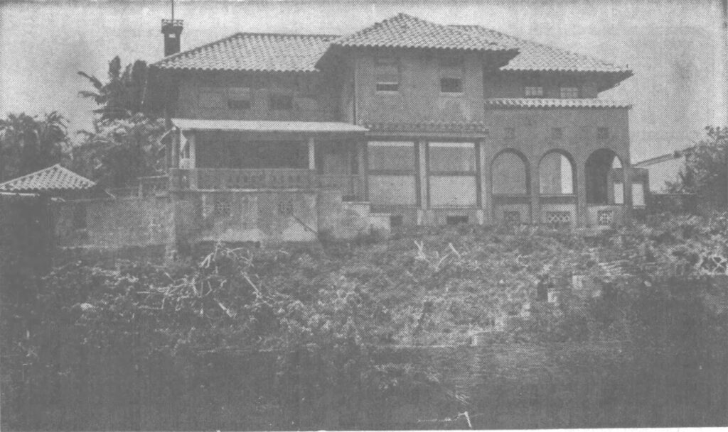
He also built his home, Dreamwood, along Kaneohe Bay. “‘Dreamwood,’ which grew out of a haole koa wilderness, is a ready-made park. There are graceful wrought iron gates guarding the entrance. A private driveway, bordered by palms, crotons and bougainvillea, leads to the three-story Bigelow home.”
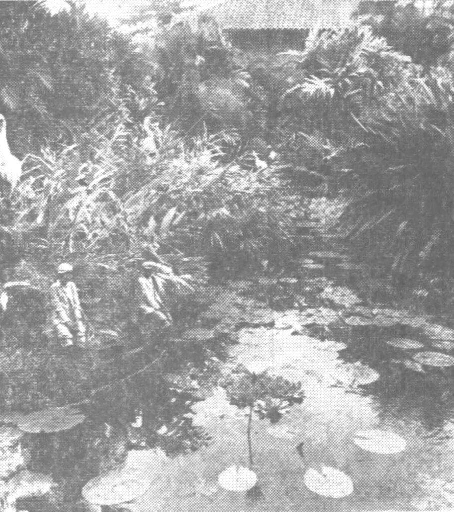
“There are six tropical fish ponds, lily pools and fountains on the grounds. Walkways are bordered by orchids. There are secluded
picnic areas. Three large greenhouses are used to cultivate orchids and rare ferns. A long pier extends into Kaneohe Bay. It has a boat shed on it.”
“Bigelows’ life-long interest in horticulture has brought rare and unusual plants to ‘Dreamwood.’ His professional skill as an engineer is seen in the intricate pools, walkways, patios and terraces.” (Advertiser, August 11, 1966)
“Dreamwood,. his 2½ acre estate at the end of Waikalua Road on Kaneohe Bay, was a gardener’s showplace which, Mayor Blaisdell said, ‘he shared generously with the community.’”
“In recent months the Bigelows, Kaneohe community leaders and City Councilmen have discussed the possibility of acquiring Dreamwood for public park purposes.”
“The bayfront estate apparently becoming too much to keep up, and Mr Bigelow wanted the tropical property to be enjoyed rather than subdivided. He and his wife said they would build a smaller home a portion of the Dreamwood estate.”
“An orchid hobbyist for more than 40 years, Mr. Bigelow won his share of prizes. He spent three decades designing, planting and
improving his gardens.” (Star Bulletin, June 20, 1966)
“Kaneohe Community leaders are proposing that the acre and a half estate with its home and marine peir be purchased and added to an existing City park at the end of Waikalua Road which borders the Bigelow property.”
“The Bigelows are planning to build a small home on the portion of ‘Dreamwood’ property which they have reserved for their own use.” (HnlAdv, Jan 13, 1966)
Other thoughts on future use suggested that the “home could house a restaurant with its operation and menu tailored to a botanical garden setting. The home’s many rooms could be set up to provide breakfast, luncheon or dinner meeting places for groups of under 100 persons.”
“Other portions of the house could be used for music club gatherings, monthly club meetings and art exhibits. The grounds would be maintained as a park where the public and tourists could enjoy the tropical plantings, orchid and fern houses.” (HnlAdv, Jan 22, 1966)
The City acquisition and park plans did not move forward. “It really is a shame the City can’t acquire more of these. But in the end it all boils down to the finances of the matter.” (City Council Chairman, Herman Lemke, HnlAdv, Jan 22, 1966)
Following Bigelow’s death, repeated advertisements noted that the 1.47-acre waterfront ‘Dreamwood’ estate was listed for sale for $275,000.
Then, the Dreamwood School was initiated on the site; it was “an experiment in therapeutic learning” offering “a therapeutic educational experience to the drug user who wants to stop and to the school drop-out”. Star Bulletin, Sep 22, 1970)
“The name is incidental, kept at the request of the owner of Bigelow mansion, which is part of Dreamwood Acres. The name fits.”
“Dr Fred Weaver and the 25 people inside the mansion have a dream they believe can come true. They are creating a school for disenchanted and alienated young to help teach them how to live happily, creatively, constructively, in today’s society while fulfilling their own dreams.”
“Weaver, psychiatrist and adolescent unit chief at Hawaii State Hospital, is acting as consultant to Dreamwood School. … The school’s primary aim is to reintegrate adult and young relationships and satisfy learning needs which the staff feels are often not supplied within the system.”
“‘We have a philosophy that sometimes the system kills initiative,’ Weaver explained. ‘You have to be turned on to learning and we want to make the turn-on natural.’”
“‘’We feel that human values are the most important – feeling good, doing what uou do, being responsible for yourself in your relationships and in what you do.’ Weaver believes that alienation occurs often because adults ‘manipulate or push the young into things.”
“‘The crisis today is too severe to allow us the luxury of treating symptoms, It is time to work on the cause.’” (Star Bulletin, Sep 22, 1970)
Then in 1971, Habilitat “signed a five-year lease with Mrs Lyman Bigelow for her Kaneohe property”. Habilitat bought the property in 1976 and continues to be the fee owner and operates its programs there.
Vinny Marino founded Habilitat on January 27, 1971 as a long term addiction treatment programs. “My idea of survival is strength found in the family. Family life is the most important experience in our lives; a good family life does shape character, and is reflected in a person’s attitude about survival. Good family life is hard to find these days; you either have it or you don’t.”
“That’s why Habilitat exists today. Habilitat believes in the family as the basis of survival. Habilitat believes the family unit must be preserved. Habilitat offers positive survival to those who want to learn. Through the family structure at Habilitat, our residents form their values, morals, conscience, and a way of life that will help them survive in this mad, mad, mad, mad world.”
“Very simply, Habilitat is an extended family of individuals who realize they need help to change, and survive without sick dependencies.” (Vinny Marino)