Images of Old Hawaiʻi

  • Home
  • About
  • Categories
    • Ali’i / Chiefs / Governance
    • American Protestant Mission
    • Buildings
    • Collections
    • Economy
    • Missionaries / Churches / Religious Buildings
    • General
    • Hawaiian Traditions
    • Other Summaries
    • Mayflower Summaries
    • Mayflower Full Summaries
    • Military
    • Place Names
    • Prominent People
    • Schools
    • Sailing, Shipping & Shipwrecks
    • Voyage of the Thaddeus
  • Collections
  • Contact
  • Follow

October 8, 2023 by Peter T Young Leave a Comment

ʻEwa

Today, you don’t necessarily use the words ʻEwa and Kalo in the same sentence – we tend to think of the ʻEwa district as dry and hot, not as a wetland taro production region.  Some early written descriptions of the place also note the dry ʻEwa Plains.

In 1793, Captain George Vancouver described this area as desolate and barren:  “From the commencement of the high land to the westward of Opooroah (Puʻuloa – Pearl Harbor) was … one barren rocky waste, nearly destitute of verdure, cultivation or inhabitants, with little variation all to the west point of the island. …”

In 1839, Missionary EO Hall described the area between Pearl Harbor and Kalaeloa as follows: “Passing all the villages (after leaving the Pearl River) at one or two of which we stopped, we crossed the barren desolate plain”.  (Robicheaux)

However, not only was ʻEwa productive, its taro was memorable.

Ua ʻai i ke kāī-koi o ‘Ewa.
He has eaten the kāī-koi taro of ‘Ewa.

Kāī is O‘ahu‘s best eating taro; one who has eaten it will always like it. Said of a youth or maiden of ‘Ewa, who, like the Kāī taro, is not easily forgotten.  (ʻŌlelo Noʻeau, 2770, Pukui)

The island of Oʻahu is divided into 6 moku (districts), consisting of: ‘Ewa, Kona, Koʻolauloa, Koʻolaupoko, Waialua and Waiʻanae. These moku were further divided into 86 ahupua‘a (land divisions within a moku.)

‘Ewa was divided into 12-ahupua‘a, consisting of (from east to west): Hālawa, ‘Aiea, Kalauao, Waimalu, Waiau, Waimano, Mānana, Waiʻawa, Waipi‘o, Waikele, Hōʻaeʻae and Honouliuli.

‘Ewa was at one time the political center for O‘ahu chiefs. This was probably due to its abundant resources that supported the households of the chiefs, particularly the many fishponds around the lochs of Puʻuloa (“long hill,) better known today as Pearl Harbor. (Cultural Surveys)  ʻEwa was the second most productive taro cultivation area on Oʻahu (just behind Waikīkī.)  (Laimana)

The salient feature of ‘Ewa, and perhaps its most notable difference, is its spacious coastal plain, surrounding the deep bays (“lochs”) of Pearl Harbor, which are actually the drowned seaward valleys of ‘Ewa’s main streams, Waikele and Waipi‘o…The lowlands, bisected by ample streams, were ideal terrain for the cultivation of irrigated taro.  (Handy, Cultural Surveys)

‘Ewa was known for a special and tasty variety of kalo (taro) called kāī which was native to the district. There were four documented varieties; the kāī ʻulaʻula (red kāī), kāī koi (kāī that pierces), kāī kea or kāī keʻokeʻo (white kāī), and kāī uliuli (dark kāī.)  (Handy)

Handy says about ‘Ewa: “The lowlands, bisected by ample streams, were ideal terrain for the cultivation of irrigated taro. The hinterland consisted of deep valleys running far back into the Koʻolau range.”

“Between the valleys were ridges, with steep sides, but a very gradual increase of altitude. The lower parts of the valley sides were excellent for the culture of yams and bananas. Farther inland grew the ‘awa for which the area was famous.”

“The length or depth of the valleys and the gradual slope of the ridges made the inhabited lowlands much more distant from the wao, or upland jungle, than was the case on the windward coast. Yet the wao here was more extensive, giving greater opportunity to forage for wild foods in famine time. (Handy)

Earlier this century, a few fishermen and some of their families built shanties by the shore where they lived, fished and traded their catch for taro at ‘Ewa. Their drinking water was taken from nearby ponds, and it was so brackish that other people could not stand to drink it.  (Maly)

An 1899 newspaper account says of the kāī koi, “That is the taro that visitors gnaw on and find it so good that they want to live until they die in ‘Ewa. The poi of kai koi is so delicious”. (Ka Loea Kalai ʻĀina 1899, Cultural Surveys) So famous was the kāī variety that ‘Ewa was sometimes affectionately called Kāī o ‘Ewa.

“I think it (wetlands) went all the way behind the Barbers Point beach area. … We’d go swim in the ponds back there, it was pretty deep, about two feet, and the birds were all around. … It seems like when there were storms out on the ocean, we’d see them come into the shore, but they’re not around anymore.”

“The wet land would get bigger when there was a lot of rain, and we had so much fun in there, but now the water has nearly all dried up. They even used to grow wet-land taro in the field behind the elementary school area when I was young. (Arline Wainaha Pu‘ulei Brede-Eaton, Maly Interview)

 ”… Bountiful taro fields covered the plain and countless coconut palms, with several huts in their shade beautified the country side. … The taro fields, the banana plantations, the plantations of sugar cane are immeasurable.” (A Botanist’s Visit to Oahu in 1831, Journal of Dr FJF Meyen, Maly)

“This district, unlike others of the island, is watered by copious and excellent springs that gush out at the foot of the mountains. From these run streams sufficient for working sugar-mills. In consequence of this supply, the district never suffers from drought, and the taro-patches are well supplied with water by the same means.”  (Commander Charles Wilkes, 1840-1841, Maly)

“Rev. Artemas Bishop, in the summer of 1836, removed with his wife and two children from Kailua, Hawaii, to Ewa, Oahu.  … Throughout the district of Ewa the common people were generally well fed. Owing to the decay of population, great breadths of taro marsh had fallen into disuse, and there was a surplus of soil and water for raising food.”  (SE Bishop, The Friend, May 1901)

As in other areas, kalo loʻi converted to rice patties.  “These days at ‘Ewa, the planting of rice is spreading among the Chinese and the Hawaiians, from Hālawa to Honouliuli and beyond. There will come a day when the mother food, taro, shall not be seen on the land.”  (Ka Lahui Hawaii, May 3, 1877, Maly)

Of course, in our discussion of the ʻEwa Moku, we need to remember that it ran from Hālawa to Honouliuli and circled Pearl Harbor.  Much of the watered wetland taro was produced off of streams from the Koʻolau; however, there is considerable mention of the wetland taro of Honouliuli (what we generally refer to today as ʻEwa.)

© 2023 Hoʻokuleana LLC

Filed Under: Place Names, Economy Tagged With: Puuloa, Kalauao, Hoaeae, Hawaii, Waimano, Oahu, Waiau, Honouliuli, Manana, Pearl Harbor, Waimalu, Halawa, Waiawa, Waipio, Waikele, Aiea, Ewa

September 11, 2023 by Peter T Young Leave a Comment

McGrew Point

“A name that will stand out prominently in Hawaiian history as long as history endures, is that of Dr John S McGrew, famous physician and esteemed citizen of the old Hawaii …”

“… whose long activities in promotion of a political union between the islands and the  United States won him the title of ‘The Father of Annexation.’”

“Dr McGrew is believed to have been the first proponent of the proposition that Hawaii should be American, the first man to realize that under the American flag the islands and their people would find their greatest opportunity and the fullest realization of their destiny.”

“‘Annexation’ McGrew, he was called by King Kalakaua, who, although naturally enough opposed to Dr McGrew’s political program, often expressed his admiration for the doctor’s sincerity and honesty of purpose.”

“Dr McGrew was an earnest advocate of annexation long before the Hawaiian monarchy was destroyed by revolution, and not for an instant did he waver from his purpose.”

“When annexation finally became an accomplished fact in 1898, five years after the revolution, Dr McGrew was hailed as ‘The Father of Annexation’ …”

“…  just as Judge Sanford B. Dole, president of the Republic of Hawaii and first governor of the American Territory, became known in later years as ‘The Grand Old Man of Hawaii.’ Two heroic figures in the evolution of Hawaii were Dole and McGrew.” (Nellist)

His first wife died in 1851.  “At the close of the [Civil] war, Dr McGrew married Pauline Gillet at Washington, DC, and the couple started on a world tour which brought them to Hawaii in 1866, where Dr McGrew abandoned the tour and decided to enter medical practice in Honolulu.”

“Upon their arrival in Hawaii, Dr and Mrs McGrew became established in a homestead located on the present site of the Alexander Young Hotel. Their home became a Honolulu landmark and was a famous social center of the city.”

“Dr McGrew was widely known for his hospitality, entertaining visitors from all parts of the world. Kate Field, the noted woman writer, died at the McGrew home while making a tour of Hawaii.”

“The old mansion was built in the 40’s by Dr RAS Wood and was owned at the time of Dr McGrew’s arrival in Hawaii by General McCook, one of the “Fighting McCook’s” of Civil War fame. Dr McGrew and family later purchased the JF Hackfeld home at Lunalilo and Emerson Streets”.

“For many years he was in charge of the Marine Hospital. He served as the first president of the Honolulu Medical Society. Maintaining the practice of his profession at a high standard, he amassed a considerable fortune, acquiring real estate and stock in growing business concerns.”

“Dr McGrew was a member of the commission which cooperated with Generals Alexander and Schofield in making a survey for an American naval base at Pearl Harbor, as provided for by the Reciprocity Treaty.  He assisted in making plans for the coaling station and lived to see a portion of the harbor improvements completed.”

“McGrew family has owned 44-acre McGrew Point at Aiea for the past 70 years [since about the 1870s]. The area has a mile of waterfrontage on the Waianae side of the peninsula and the home of [McGrew’s grandson] on the other side.”

“The family devoted years of effort of establishment of a plantation of fruit trees and other general improvements. Dignitaries from around the world, including top ranking army and navy officers, have been guests at the Cooper home.”

“[Katherine McGrew was born in Honolulu in February, 1873 is the daughter of Dr John S McGrew. She married Charles Bryant Cooper on March 24, 1897.]” Adv, Aug 21, 1946)

In 1944, “An order giving the federal government possession of about 49 acres at McGrew point in the Pearl Harbor area has been signed by Judge J Frank McLaughlin.” (Hnl SB, July 18, 1944)

The Loko Pa‘aiau Fishpond is located at McGrew Point Navy housing, Oahu, Hawaii. It is one of only three fishponds out of an original 22 in the Pearl Harbor area which are still relatively intact. (Navy)

Efforts are underway to restore it. Currently located on land leased for Navy housing, Aliʻi Pauahi Hawaiian Civic Club and the ʻAiea Community Association see Loko Paʻaiau as a place where local community members, visitors, and military families can come together to build relationships to the land and each other.

In partnership with the Navy, local community groups involved in the restoration of Loko Paʻaiau have focused their efforts on bringing people together to raise cultural awareness of the fishponds and connect people to the history and culture of the area.  (McDaniel) McGrew Point now has military housing.

© 2023 Ho‘okuleana LLC

Filed Under: Prominent People, General, Place Names Tagged With: Hawaii, Pearl Harbor, John Strayer McGrew, McGrew Point

July 14, 2023 by Peter T Young 2 Comments

Ke Awa Lau O Puʻuloa

During ancient times, various land divisions were used to divide and identify areas of control. Islands were divided into moku; moku were divided into ahupuaʻa. A common feature in each ahupuaʻa was water, typically in the form of a stream or spring.

The Island of O’ahu had six Moku: Kona, Koʻolaupoko, Koʻolauloa, Waialua, Waiʻanae and ʻEwa.

‘Ewa was divided into 12-ahupua‘a, consisting of (from east to west): Hālawa, ‘Aiea, Kalauao, Waimalu, Waiau, Waimano, Mānana, Waiʻawa, Waipi‘o, Waikele, Hōʻaeʻae and Honouliuli.

Some stories, when first recorded in the 19th- Century, refer to ʻEwa as the first area populated on Oʻahu by the immigrant Polynesians. ‘Ewa was at one time the political center for O‘ahu chiefs.

This was probably due to its abundant resources that supported the households of the chiefs, particularly the many fishponds around the lochs of Puʻuloa (“long hill,) better known today as Pearl Harbor. (Cultural Surveys)

Each had fisheries in the harbor, floodplains with irrigated kalo and fishponds, and interior (lower kula valley streams/gulches) and mountain forests. (Kirch)

Puʻuloa or Ke Awa Lau O Puʻuloa (the many harbored-sea of Puʻuloa) is situated here.

All water sources in each of the twelve ahupuaʻa of ʻEwa met in Puʻuloa. This was the only moku in all the islands where all waters from its ahupuaʻa did this.

Puʻuloa and Ke Awa Lau O Puʻuloa are just a couple of its traditional names. It was also known as Awawalei (“garland (lei) of harbors,”) Awalau (“harbor with many inlets”) and Huhui na ʻōpua i Awalau (The clouds met at Awalau.)

Today, we generally call this place Pearl Harbor. The name Pearl Harbor is one of the few English place names in Hawaiʻi that is a close translation of another of its traditional Hawaiian names, Wai Momi (“Pearl Water.”)

Some of the traditional themes associated with this area include connections with Kahiki (Tahiti,) the traditional homeland of Hawaiians.

Legend tells that Kanekuaʻana (a moʻo, or water lizard) came from Kahiki and brought with her the pipi, or pearl oyster. The harbor was teeming with pearl-producing oysters until the late-1800s. (The general belief is that runoff sedimentation eventually smothered the oyster habitat.)

The pipi was called the “iʻa hamau leo” or “fish with a silenced voice.” It was not the pipi that was silent but the people who gathered them (if they spoke, wind would ripple the water and the oysters would vanish.)

There are several versions of the chief Kahaʻi leaving from Kalaeloa (Barber’s Point) for a trip to Kahiki; on his return to the Hawaiian Islands, he brought back the first breadfruit and planted it at Puʻuloa.

Traditional accounts indicate several of the fishponds in the Puʻuloa area were believed to have been constructed by Kāne and Kanaloa. Directing the menehune, they made the pond Kapākule (aka Pākule,) which they stocked with all manner of fish. (Kumupono, Hoakalei)

“On the left side of [Kapākule] pond stood the stone called Hina, which represented a goddess of the sea by that name. Each time the sea ebbed, the rock became gradually visible, vanishing again under water at high tide. Ku, another stone on the right, was never seen above sea level. This stone represented Ku’ula, Red Ku, a god of fish and fishermen. (Pukui)

“[T]he harbor of Ewa, or Pearl River, [is] situated on the Island of Oahu, about 7 miles west of Honolulu. Pearl River is a fine sheet of deep water extending inland about 6 miles from its month …”

“Pearl River is not a true river; it partakes more of the character of an estuary. It is divided into three portions called ‘locks’ – the east lock, the middle lock, and the west lock, the three together affording some 30 miles of water front, with deep water in the channels.” (General JM Schofield and General BS Alexander, 1872)

Puʻuloa Salt Works (property of JI Dowsett) “are at the west side of the entrance to Pearl River, and the windmill is a prominent object in the landscape as we enter. It is also one of the guides in steeling vessels inward. On the eastern side and opposite to the Puʻuloa buildings, is the fishery, where are a number of buildings inhabited by Chinamen.” (Daily Bulletin, January 6, 1889)

Puʻuloa was originally an extensive, shallow embayment. Keaunui, the head of the powerful and celebrated ʻEwa chiefs, is attributed for having cut a navigable channel near the Puʻuloa saltworks, by which the great estuary, known as “Pearl River,” was for the first time rendered accessible to navigation.

Puʻuloa was regarded as the home of the shark goddess Kaʻahupahau and her brother Kahiʻuka in Hawaiian legends. They were said to live in a cave at the entrance to Puʻuloa and guarded the waters against man-eating sharks.

“There is ample evidence that the lonely scenes, upon which we now gaze with wondering curiosity, were once thickly peopled; and at that period the gospel had not reached Pearl River. Among the objects of their heathen worship was the shark, whoso numbers at Pearl River in those days were very abundant.” (Daily Bulletin, January 6, 1889)

Moku‘ume‘ume (meaning “island of strife”) is a small island located in Pearl Harbor on the Island of Oʻahu. It is entirely surrounded by water deep enough to accommodate deep draft ocean-going vessels. We now call it Ford Island.

The first known foreigner to enter the channel of the Pearl Harbor area, Captain George Vancouver, started to explore the area, but stopped when he realized that the entrance was not deep enough for large ships to pass through.

“If the water upon the bar should be deepened, which I doubt not can be effected, it would afford the best and most capacious harbor in the Pacific.” (Commodore Charles Wilkes, 1840)

In the nineteenth century, the peninsula between Middle Loch and East Loch (part of the Mānana ahupuaʻa) had numerous fishponds, some rice fields, pasture land at the tip, and oyster beds offshore.

As a means of solidifying a site in the central Pacific, the US negotiated an amendment to the Treaty of Reciprocity in 1887. King Kalākaua in his speech before the opening session of the 1887 Hawaiian Legislature stated (November 3, 1887:)

“I take great pleasure in informing you that the Treaty of Reciprocity with the United States of America has been definitely extended for seven years upon the same terms as those in the original treaty …”

“… with the addition of a clause granting to national vessels of the United States the exclusive privilege of entering Pearl River Harbor and establishing there a coaling and repair station.”

“This has been done after mature deliberation and the interchange between my Government and that of the United States of an interpretation of the said clause …”

“… whereby it is agreed and understood that it does not cede any territory or part with or impair any right of sovereignty or jurisdiction on the part of the Hawaiian Kingdom and that such privilege is coterminous with the treaty.”

“I regard this as one of the most important events of my reign, and I sincerely believe that it will re-establish the commercial progress and prosperity which began with the Reciprocity Treaty.” (Kalākaua)

In 1890 some of the Mānana lands became the first planned subdivision outside of urban Honolulu (Pearl City, named in a contest and developed by Benjamin F Dillingham as a way to increase passenger traffic on his Oahu Railway and Land Company (OR&L) trains.)

© 2023 Hoʻokuleana LLC

Filed Under: Place Names Tagged With: Hawaii, Oahu, Kalakaua, Pearl Harbor, Treaty of Reciprocity, Oahu Railway and Land Company, Dillingham, Ewa, Ke Awa Lau O Puuloa

May 21, 2023 by Peter T Young Leave a Comment

West Loch Tragedy

Despite its moniker, “Large Slow Target,” the ‘Landing Ship, Tank’ (LST) was an important naval vessel created during World War II to support amphibious operations by carrying significant quantities of vehicles, cargo and landing troops directly onto an unimproved shore.

An LST, 382-feet long and 50-feet wide, carried a crew of 8-10 officers and 115 enlisted men; in addition, there were berths for over 200-troops and a capacity to carry a 2,100-ton load of tanks, trucks, jeeps and weapon carriers and associated munitions and supplies.

1,051 LSTs were constructed and used in the war effort; they were used in the Atlantic and the Pacific.  Only 26 were lost in WWII due to enemy action.

However, in Hawaiʻi, a once secret and often-forgotten tragedy struck at Pearl Harbor, in 1944.

At the time, the Allied forces were preparing for two assaults – one was in the Atlantic (D-Day, June 6, 1944 – nearly 200,000-Allied troops on 7,000-ships and more than 3,000-aircraft headed toward Normandy, France.)

The other was in the Pacific (Saipan, June 15, 1944 – more than 300-landing vehicles put 8,000-Marines on the west coast of Saipan; eleven support ships covered the Marine landings.)

In preparation for the Saipan assault, in late-May, crews were loading ships at the US Pacific Fleet base at West Loch, Pearl Harbor.

(Pearl Harbor is divided into a series of lochs that fan out from Ford Island that sits in the center of harbor. West Loch was the staging area for the invasion fleets of the Pacific.)

29-LSTs, plus a variety of other amphibious vessels that would support the initial landings and follow-on operations, were tightly clustered while their hulls and decks were being filled with ammunition, supplies and other material.

That list of items included munitions of all calibers and types, propellants, aviation gasoline, vehicle fuel and a variety of other volatile cargoes.

Nested beam-to-beam at piers off of Hanaloa and Intrepid Points opposite Lualualei (now known as Naval Magazine Pearl Harbor) were six compact rows of LSTs and other craft moored at “Tare” piers jutting into the adjoining waters of West Loch and Walker Bay.

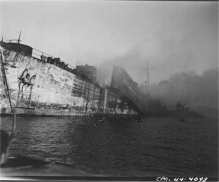
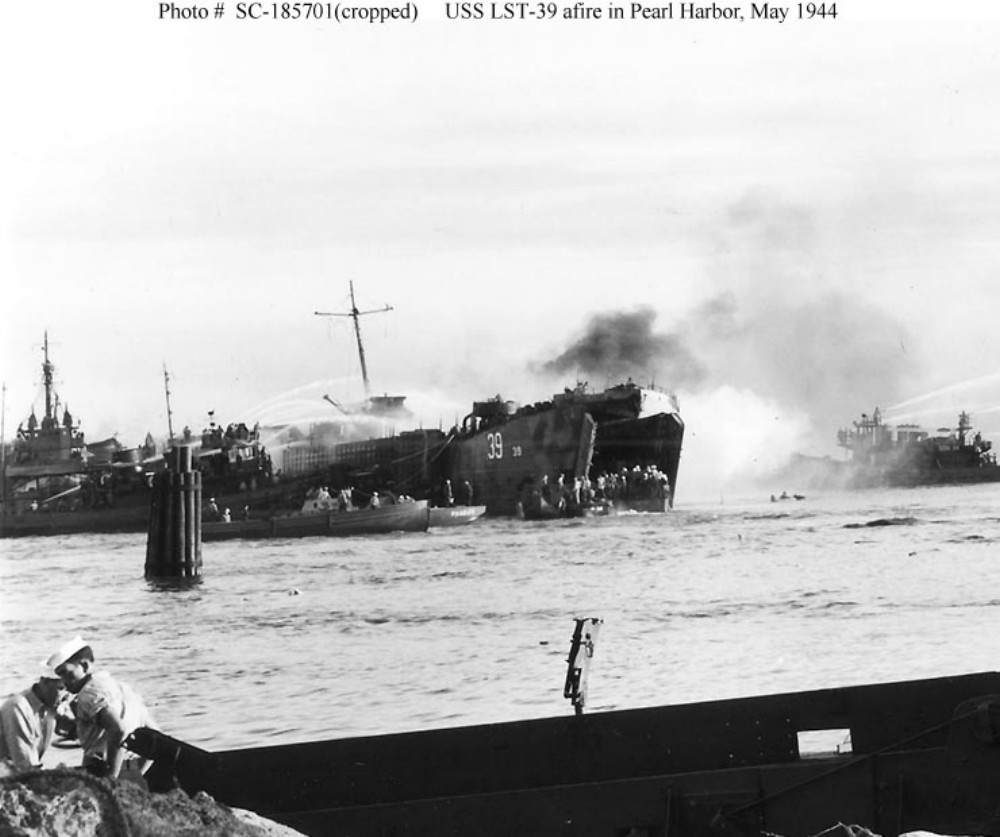
At 1508 (3:08 pm) May 21, 1944, Lualualei’s tranquility was shattered by a deafening explosion which thundered across most of Oʻahu.

Without warning, an enormous mushroom of orange black fire encapsulated LST-353 at Tare 8, obliterating it and most of the seven other ships from view as the giant fireball burst into the cloudless sky.  (Oliver)

The explosions continued, damaging more than 20 buildings shoreside at the West Loch facility. For 24-hours fires raged aboard the stricken ships.  (NPS)

Had the Japanese struck again – another sneak attack on Pearl Harbor? … No one knew.

Then the ground shook to a second blast. Earthquake?  Volcano?  Aerial bombs?  Alarms rang as another shattering blast of even greater magnitude jolted the air.  (Oliver)

Predictably, flaming gasoline and exploding ammunition soon began to take a frightful toll of the Soldiers, Sailors and Marines loading and manning the ships.

Fires and explosions drove back ships and craft engaged in firefighting efforts, each time those vessels re-entered the inferno to contain the fires and keep the disaster from spreading to the rest of the Fleet anchorage. (USNavalInstitute)

Several investigations sought to find the reason for such a disaster, but no conclusive evidence as how it occurred was decided upon.  Two major causes emerged as most likely: Either a fused mortar round was accidently dropped while unloading the LCT aboard LST-353, or the initial explosion was caused by gasoline vapors.  (Oliver)

The Navy put a “Top Secret” status on the tragedy.  Survivors and eyewitnesses to the calamity were warned under threat of prosecution not to make any mention of the disaster in letters or calls to family members. To the outside world the tragedy at West Loch simply never happened.  (Oliver)  (It was declassified in 1960.)

The total casualties were 392 dead; 163 sailors, the rest young Marines from the newly formed 2nd and 4th Marine Divisions, and 396 injured – eight ships were lost.

It was recommended that LSTs no longer be nested, so that disaster like that at West Loch could be avoided. Fleet Admiral Chester Nimitz disagreed. He felt that facilities were too limited at Pearl and that the nesting was necessary. “It is a calculated risk that must be accepted.”  (NPS)

Despite the losses, the Saipan invasion force put to sea as scheduled on June 5, 1944, just as the largest invasion armada ever to sail was crossing the English Channel en route to the Normandy beaches.

On June 15, 1944, during the Pacific Campaign of World War II (1939-45,) Admiral Turner was in charge of the assault on Saipan.  At 05:42, his orders came – “Land the landing force.” In position, about 1,250 yards from the line of departure, 34-LSTs moved into line. Two huge doors on the bow of each ship opened and dropped their ramps into the water. (BattleOfSaipan)

US Marines (having earlier trained at Camp Tarawa, Waimea, Hawaiʻi Island and Camp Maui, Ha‘ikū, Maui) stormed the beaches of the strategically significant Japanese island of Saipan, with a goal of gaining a crucial air base from which the US could launch its new long-range B-29 bombers directly at Japan’s home islands.

Facing fierce Japanese resistance, Americans poured from their landing crafts to establish a beachhead, battling Japanese soldiers inland and forcing the Japanese army to retreat north. Fighting became especially brutal and prolonged around Mount Tapotchau, Saipan’s highest peak, and Marines gave battle sites in the area names such as “Death Valley” and “Purple Heart Ridge.”  (history-com)

This was the first action of Operation Forager, the conquest of the Marianas, consisting of two Marine Divisions, a US Army Division, and the required force and support units from an amphibious armada of nearly 600-ships and craft.

When the US finally trapped the Japanese in the northern part of the island, Japanese soldiers launched a massive but futile banzai charge. On July 9, the US flag was raised in victory over Saipan.  (history-com)

© 2023 Hoʻokuleana LLC


Filed Under: Military Tagged With: West Loch, Hawaii, Oahu, Pearl Harbor, LST

December 7, 2022 by Peter T Young Leave a Comment

“Something was happening”

The Japanese attack on Pearl Harbor on December 7, 1941 lasted 110 minutes, from 7:55 am until 9:45 am. Japanese naval forces included 4 heavy aircraft carriers, 2 heavy cruisers, 35 submarines, 2 light cruisers, 9 oilers, 2 battleships and 11 destroyers.

The attacking forces came in two waves, the first consisting of 183 aircraft which included 40 torpedo planes, 49 level bombers, 51 dive bombers and 43 fighters. The second wave included 170 planes, 54 of them level bombers, 80 dive-bombers and 36 fighters.  Over 350 Japanese planes were involved in overall attack.

As a result of the December 7, 1941 attack, there were 2,403-people killed and 1,178-wounded. Among the deceased were 2,008-Navy personnel, 109-Marine, 218-Army and 68-civilians.  (navy-mil)

For part of the attack, and aftermath, first, let’s look back.

In 1899, Gorokichi Nakasugi, a Japanese shipbuilder, brought a traditional 34-foot Japanese sailing sampan to Hawai‘i; this led to a unique class of vessels and distinctive maritime culture associated with the rise of the commercial fishing industry in Hawai‘i.

(The term ‘Sampan,’ although usually associate with the Japanese in Hawaiʻi, comes from the Chinese language, meaning three (san) boards (ban,) describing a small simple skiff.)  (VanTilburg)

Japanese-trained shipwrights adapted the original sampan design to the rough waters of the Hawaiian Islands.  The fishermen used traditional live bait, pole-and-line method of fishing and unloaded their catches of aku (bonito, skipjack) and ahi (yellow-fin tuna) at Kewalo Basin.

Local Japanese fishermen opened the commercial tuna industry in Hawaiʻi in conjunction with the innovation of modern packing plants.  It was the ability to can tuna for the distant market which really made possible the expansion and modernization of the fishing fleet.  The industry benefited American canneries.

Vessels began to change with time, as well.  Gasoline engines were fitted into boats beginning in 1905, and more suitable marine diesels by 1927. Shortly thereafter the prominent deckhouse made its appearance.  The Sampans became perfectly adapted to the rough waters between the islands.  (VanTilburg)

The sampan aku fleet was based at Kewalo Basin by 1930, and the McFarlane Tuna Company (later known as Hawaiian Tuna Packers) built a shipyard there in 1929 and a new tuna cannery at the basin in 1933.

By 1940, there were over 450-sampans in the Territory of Hawaiʻi, making the commercial fishery the Islands’ third largest industry behind sugar and pineapple.

That brings us to December 1941, more specifically, December 4 – four sampans (Kiho Maru, Myojin Maru, Shin-ei Maru and the Sumiyoshi Maru) set out for fishing off Oʻahu’s leeward coast.

Later, on the morning of December 7, the Ward (US Destroyer No. 139,) conducting routine antisubmarine patrols in the Hawaiian area, had the distinction of firing the first American gun in anger during the Pacific war.  She searched for a suspected submarine and subsequently fired shots at its conning tower.

(In 2002, the University of Hawaiʻi, Hawaiʻi Undersea Research Lab (HURL) team found the submarine about three to four miles off Pearl Harbor and verified it was hit and sunk by the Ward.  (Burlingame))

Heading home, the Ward soon spotted a Japanese fishing sampan, one of many that was a familiar sight in the waters in the Hawaiian archipelago (not part of the four noted before.)

A fisherman suddenly started waving a white flag perhaps he had seen the determined depth-charge attacks and thought that the Americans would bomb anything that moved. Ward slowed and closed to investigate and took the small craft in tow to turn her over to the Coast Guard for disposition.

Nearing the harbor entrance around 0800, those on deck heard the sound of gunfire and explosions, as smoke began to boil into the skies over Pearl Harbor. (Dictionary of American Naval Fighting Ships)

“Something was happening.”

The Ward had returned and witnessed the December 7, 1941 attack on Pearl Harbor.

On the morning of December 8, newspapers announced that all unidentified boats approaching Oʻahu would be fired upon. It was feared that the local fishing fleet, manned predominantly by Japanese might have had rendezvous with Japanese warships. (Roehner)

Then, the fateful day for the four sampans as they were heading home.  “All of a sudden, there were four or five Army P40s flying over us.  Each picked out a target and attacked.”

The war-planes strafed the four fishing boats (Kiho Maru, Myojin Maru, Shin-ei Maru and the Sumiyoshi Maru) about 2-miles off Barber’s Point, about 10-miles west of Pearl Harbor, killing six civilians (nine crewmen survived the mid-morning attack, but most were wounded – most of the crew on the boats were American citizens.)

After the planes attacked, a destroyer arrived on the scene and dispatched launches to tow the sampans, with the dead and wounded, back to Kewalo Basin.  They were then taken to a civilian hospital where the wounded were kept under armed guard.    (European Stars and Stripes, December 9, 1977)

The dead were brought from the waterfront to Hosoi Funeral Parlor. They were: Ogawa Mataichi, Kaichi Okada, Sutematsu Kida, Kiichi Kida, Kiho Uyehara, Riyozo Okogi.  (Scrapbook of Women of WWII Hawaiʻi)

Again on December 12th, sampans were strafed off of both Kailua and Kohala coasts.  (VanTilburg)

World War II had the single largest impact on the sampan fishing industry.   During the war, the fleet was immediately limited to operating only during certain narrow hours in a few selected near shore areas. This, of course, was devastating to the fishery. By the end of 1942, the annual yield was down by a staggering 99%.  (VanTilburg)

In 1967, 26 years after the incident, the widow of the Kiho Maru skipper received $8,000.  Another received about $2,500 and proceeds from the sale of fish that was in his boat on the day of the attack.  (European Stars and Stripes, December 9, 1977)


© 2022 Hoʻokuleana LLC


Filed Under: Military Tagged With: Hawaii, Oahu, Pearl Harbor, Sampan, Kewalo Basin

  • « Previous Page
  • 1
  • 2
  • 3
  • 4
  • 5
  • 6
  • …
  • 13
  • Next Page »

Images of Old Hawaiʻi

People, places, and events in Hawaiʻi’s past come alive through text and media in “Images of Old Hawaiʻi.” These posts are informal historic summaries presented for personal, non-commercial, and educational purposes.

Info@Hookuleana.com

Connect with Us

  • Email
  • Facebook
  • LinkedIn
  • Twitter
  • YouTube

Recent Posts

  • ‘Hilo Walk of Fame’
  • Men of the Mission
  • Train Accident at Maulua Tunnel
  • Beyond the Boundaries
  • Napa Meets Hawaiʻi
  • Squirmin’ Herman
  • Drinking Smoke

Categories

  • General
  • Ali'i / Chiefs / Governance
  • Buildings
  • Missionaries / Churches / Religious Buildings
  • Hawaiian Traditions
  • Military
  • Place Names
  • Prominent People
  • Schools
  • Sailing, Shipping & Shipwrecks
  • Economy
  • Voyage of the Thaddeus
  • Mayflower Summaries
  • American Revolution

Tags

Albatross Al Capone Ane Keohokalole Archibald Campbell Bernice Pauahi Bishop Charles Reed Bishop Downtown Honolulu Eruption Founder's Day George Patton Great Wall of Kuakini Green Sea Turtle Hawaii Hawaii Island Hermes Hilo Holoikauaua Honolulu Isaac Davis James Robinson Kamae Kamaeokalani Kamanawa Kameeiamoku Kamehameha Schools Lalani Village Lava Flow Lelia Byrd Liliuokalani Mao Math Mauna Loa Midway Monk Seal Northwestern Hawaiian Islands Oahu Papahanaumokuakea Marine National Monument Pearl Pualani Mossman Queen Liliuokalani Thomas Jaggar Volcano Waikiki Wake Wisdom

Hoʻokuleana LLC

Hoʻokuleana LLC is a Planning and Consulting firm assisting property owners with Land Use Planning efforts, including Environmental Review, Entitlement Process, Permitting, Community Outreach, etc. We are uniquely positioned to assist you in a variety of needs.

Info@Hookuleana.com

Copyright © 2012-2024 Peter T Young, Hoʻokuleana LLC


Loading Comments...