Images of Old Hawaiʻi

  • Home
  • About
  • Categories
    • Ali’i / Chiefs / Governance
    • American Protestant Mission
    • Buildings
    • Collections
    • Economy
    • Missionaries / Churches / Religious Buildings
    • General
    • Hawaiian Traditions
    • Other Summaries
    • Mayflower Summaries
    • Mayflower Full Summaries
    • Military
    • Place Names
    • Prominent People
    • Schools
    • Sailing, Shipping & Shipwrecks
    • Voyage of the Thaddeus
  • Collections
  • Contact
  • Follow

June 5, 2023 by Peter T Young Leave a Comment

Pukaʻōmaʻomaʻo

Traditions on the island of Oʻahu note Mā’ilikūkahi was a ruling chief around 1500 (about the time Columbus crossed the Atlantic.) Māʻilikūkahi is said to have enacted a code of laws in which theft from the people by chiefs was forbidden.

A son of Mā’ilikūkahi was Kalona-nui, who in turn had a son called Kalamakua. Kalamakua is said to have been responsible for developing a large system of taro planting across the Waikīkī-Kapahulu-Mōʻiliʻili-Mānoa area. The extensive loʻi kalo were irrigated by water drawn from the Mānoa and Pālolo Valley streams and large springs in the area.

In 1792, Captain George Vancouver described Mānoa Valley on a hike from Waikīkī in search of drinking water: “We found the land in a high state of cultivation, mostly under immediate crops of taro; and abounding with a variety of wild fowl chiefly of the duck kind …”

“The sides of the hills, which were in some distance, seemed rocky and barren; the intermediate vallies, which were all inhabited, produced some large trees and made a pleasing appearance. The plains, however, if we may judge from the labour bestowed on their cultivation, seem to afford the principal proportion of the different vegetable productions …” (Edinburgh Gazetteer)

One century later, before it was urbanized, Mānoa Valley was described by Thrum (1892:)  “Manoa is both broad and low …”

“… with towering hills on both sides that join the forest clad mountain range at the head, whose summits are often hid in cloud land, gathering moisture there from to feed the springs in the various recesses that in turn supply the streams winding through the valley, or watering the vast fields of growing taro, to which industry the valley is devoted.”

“The higher portions and foot hills also give pasturage to the stock of more than one dairy enterprise.”

Handy (in his book Hawaiian Planter) writes that in ancient days, all of the level land in upper Mānoa was developed into taro flats and was well-watered, level land that was better adapted to terracing than neighboring Nuʻuanu.  The entire floor of Mānoa Valley was a “checkerboard of taro patches.”  “The terraces extended along Manoa Stream as far as there is a suitable land for irrigating.”

The well-watered, fertile and relatively level lands of Mānoa Valley supported extensive wet taro cultivation well into the twentieth century. Handy and Handy estimated that in 1931 “there were still about 100 terraces in which wet taro was planted, although these represented less than a tenth of the area that was once planted by Hawaiians.” (Cultural Surveys)

Mānoa Valley was a favored spot of the Ali‘i, including Kamehameha I, Chief Boki (Governor of O‘ahu), Haʻalilio (an advisor to King Kamehameha III,) Princess Victoria, Kanaʻina (father of King Lunalilo), Lunalilo, Keʻelikōlani (half-sister of Kamehameha IV) and Queen Lili‘uokalani.  The chiefs lived on the west side, the commoners on the east.

Queen Kaʻahumanu lived there; her home was called Pukaʻōmaʻomaʻo (Green Gateway.)  It was situated deep in the valley (lit., green opening; referring to its green painted doors and blinds – It is alternatively referred to as Pukaʻōmaʻo.)

“Her residence is beautifully situated and the selection of the spot quite in taste. The house … stands on the height of a gently swelling knoll, commanding, in front, an open and extensive view of all the rich plantations of the valley; of the mountain streams meandering through them … of the district of Waititi; and of Diamond Hill, and a considerable part of the plain, with the ocean far beyond.” (Stewart; Sterling & Summers)

It was doubtless the same sort of grass house which was in general use, although probably more spacious and elaborate as befitted a queen. The dimension in one direction was 60 feet. The place name of the area was known as Kahoiwai, or “Returning Waters.”

“Immediately behind the house, and partially flanking it on either side, is a delightful grove of the dark leaved and crimson blossomed ʻŌhia, so thick and so shady … filled with cool and retired walks and natural retreats, and echoing to the cheerful notes of the little songsters, who find security in its shades to build their nests and lay their young.”

“The view of the head of the valley inland, from the clumps and single trees edging this copse, is very rich and beautiful; presenting a circuit of two or three miles delightfully variegated by hill and dale, wood and lawn, and enclosed in a sweep of splendid mountains, one of which in the centre rises to a height of three thousand feet.”

“In one edge of this grove, a few rods from the house, stands a little cottage built by Kaahumanu, for the accommodation of the missionaries who visit her when at this residence. … (It) is very frequently occupied a day or two at a time, by one and another of the families most enervated by the heat and dust, the toil, and various exhausting cares of the establishment at the sea-shore.“  (Stewart; Sterling & Summers)

“Not far makai … High Chief Kalanimōku, had very early allotted to the Mission the use of farm plots thus noted in its journal of June, 1823: “On Monday the 2d, Krimakoo and the king’s mother granted to the brethren three small pieces of land cultivated with taro, potatoes, bananas, melons, &c. and containing nineteen bread-fruit trees, from which they may derive no small portion of the fruit and vegetables needed by the family.”  (Damon)

Then, in mid-1832, Kaʻahumanu became ill and was taken to her house in Mānoa, where a bed of maile and leaves of ginger was prepared.   “Her strength failed daily.  She was gentle as a lamb, and treated her attendants with great tenderness.  She would say to her waiting women, ‘Do sit down; you are very tired; I make you weary.’”  (Bingham)

“The king, his sister, other members of the aliʻi and many retainers had already arrived at Pukaomaomao and had dressed the large grass house for the dying queen’s last homecoming. The walls of the main room had been hung with ropes of sweet maile and decorated with lehua blossoms and great stalks of fragrant mountain ginger.”

“The couch upon which Kaahumanu was to rest had been prepared with loving care. Spread first with sweet-scented made and ginger leaves, it was then covered with a golden velvet coverlet. At the head and foot stood towering leather kahilis. Over a chair nearby was draped the Kamehameha feather cloak which had been worn by Kaahumanu since the monarch’s death.”  (Mellon; Sterling & Summers)

“The slow and solemn tolling of the bell struck on the pained ear as it had never done before in the Sandwich Islands. In other bereavements, after the Gospel took effect, we had not only had the care and promise of our heavenly Father, but a queen-mother remaining, whose force, integrity, and kindness, could be relied on still.”

“But words can but feebly express the emotions that struggled in the bosoms of some who counted themselves mourners in those solemn hours; while memory glanced back through her most singular history, and faith followed her course onward, far into the future.”  (Hiram Bingham)

Her death took place at ten minutes past 3 o’clock on the morning of June 5, 1832, “after an illness of about 3 weeks in which she exhibited her unabated attachment to the Christian teachers and reliance on Christ, her Saviour.”  (Hiram Bingham)

© 2023 Hoʻokuleana LLC


Filed Under: Ali'i / Chiefs / Governance, Buildings, Place Names Tagged With: Pukaomaomao, Hawaii, Oahu, Kaahumanu, Queen Kaahumanu, Manoa

May 21, 2023 by Peter T Young Leave a Comment

West Loch Tragedy

Despite its moniker, “Large Slow Target,” the ‘Landing Ship, Tank’ (LST) was an important naval vessel created during World War II to support amphibious operations by carrying significant quantities of vehicles, cargo and landing troops directly onto an unimproved shore.

An LST, 382-feet long and 50-feet wide, carried a crew of 8-10 officers and 115 enlisted men; in addition, there were berths for over 200-troops and a capacity to carry a 2,100-ton load of tanks, trucks, jeeps and weapon carriers and associated munitions and supplies.

1,051 LSTs were constructed and used in the war effort; they were used in the Atlantic and the Pacific.  Only 26 were lost in WWII due to enemy action.

However, in Hawaiʻi, a once secret and often-forgotten tragedy struck at Pearl Harbor, in 1944.

At the time, the Allied forces were preparing for two assaults – one was in the Atlantic (D-Day, June 6, 1944 – nearly 200,000-Allied troops on 7,000-ships and more than 3,000-aircraft headed toward Normandy, France.)

The other was in the Pacific (Saipan, June 15, 1944 – more than 300-landing vehicles put 8,000-Marines on the west coast of Saipan; eleven support ships covered the Marine landings.)

In preparation for the Saipan assault, in late-May, crews were loading ships at the US Pacific Fleet base at West Loch, Pearl Harbor.

(Pearl Harbor is divided into a series of lochs that fan out from Ford Island that sits in the center of harbor. West Loch was the staging area for the invasion fleets of the Pacific.)

29-LSTs, plus a variety of other amphibious vessels that would support the initial landings and follow-on operations, were tightly clustered while their hulls and decks were being filled with ammunition, supplies and other material.

That list of items included munitions of all calibers and types, propellants, aviation gasoline, vehicle fuel and a variety of other volatile cargoes.

Nested beam-to-beam at piers off of Hanaloa and Intrepid Points opposite Lualualei (now known as Naval Magazine Pearl Harbor) were six compact rows of LSTs and other craft moored at “Tare” piers jutting into the adjoining waters of West Loch and Walker Bay.

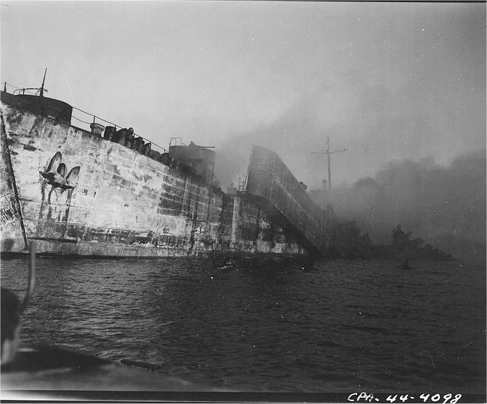
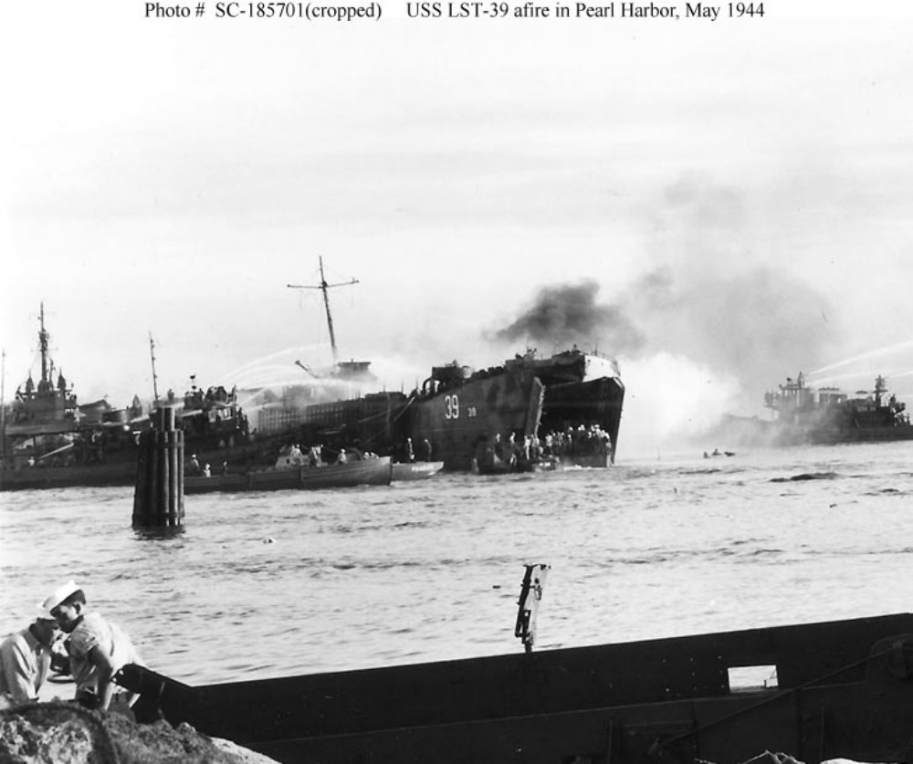
At 1508 (3:08 pm) May 21, 1944, Lualualei’s tranquility was shattered by a deafening explosion which thundered across most of Oʻahu.

Without warning, an enormous mushroom of orange black fire encapsulated LST-353 at Tare 8, obliterating it and most of the seven other ships from view as the giant fireball burst into the cloudless sky.  (Oliver)

The explosions continued, damaging more than 20 buildings shoreside at the West Loch facility. For 24-hours fires raged aboard the stricken ships.  (NPS)

Had the Japanese struck again – another sneak attack on Pearl Harbor? … No one knew.

Then the ground shook to a second blast. Earthquake?  Volcano?  Aerial bombs?  Alarms rang as another shattering blast of even greater magnitude jolted the air.  (Oliver)

Predictably, flaming gasoline and exploding ammunition soon began to take a frightful toll of the Soldiers, Sailors and Marines loading and manning the ships.

Fires and explosions drove back ships and craft engaged in firefighting efforts, each time those vessels re-entered the inferno to contain the fires and keep the disaster from spreading to the rest of the Fleet anchorage. (USNavalInstitute)

Several investigations sought to find the reason for such a disaster, but no conclusive evidence as how it occurred was decided upon.  Two major causes emerged as most likely: Either a fused mortar round was accidently dropped while unloading the LCT aboard LST-353, or the initial explosion was caused by gasoline vapors.  (Oliver)

The Navy put a “Top Secret” status on the tragedy.  Survivors and eyewitnesses to the calamity were warned under threat of prosecution not to make any mention of the disaster in letters or calls to family members. To the outside world the tragedy at West Loch simply never happened.  (Oliver)  (It was declassified in 1960.)

The total casualties were 392 dead; 163 sailors, the rest young Marines from the newly formed 2nd and 4th Marine Divisions, and 396 injured – eight ships were lost.

It was recommended that LSTs no longer be nested, so that disaster like that at West Loch could be avoided. Fleet Admiral Chester Nimitz disagreed. He felt that facilities were too limited at Pearl and that the nesting was necessary. “It is a calculated risk that must be accepted.”  (NPS)

Despite the losses, the Saipan invasion force put to sea as scheduled on June 5, 1944, just as the largest invasion armada ever to sail was crossing the English Channel en route to the Normandy beaches.

On June 15, 1944, during the Pacific Campaign of World War II (1939-45,) Admiral Turner was in charge of the assault on Saipan.  At 05:42, his orders came – “Land the landing force.” In position, about 1,250 yards from the line of departure, 34-LSTs moved into line. Two huge doors on the bow of each ship opened and dropped their ramps into the water. (BattleOfSaipan)

US Marines (having earlier trained at Camp Tarawa, Waimea, Hawaiʻi Island and Camp Maui, Ha‘ikū, Maui) stormed the beaches of the strategically significant Japanese island of Saipan, with a goal of gaining a crucial air base from which the US could launch its new long-range B-29 bombers directly at Japan’s home islands.

Facing fierce Japanese resistance, Americans poured from their landing crafts to establish a beachhead, battling Japanese soldiers inland and forcing the Japanese army to retreat north. Fighting became especially brutal and prolonged around Mount Tapotchau, Saipan’s highest peak, and Marines gave battle sites in the area names such as “Death Valley” and “Purple Heart Ridge.”  (history-com)

This was the first action of Operation Forager, the conquest of the Marianas, consisting of two Marine Divisions, a US Army Division, and the required force and support units from an amphibious armada of nearly 600-ships and craft.

When the US finally trapped the Japanese in the northern part of the island, Japanese soldiers launched a massive but futile banzai charge. On July 9, the US flag was raised in victory over Saipan.  (history-com)

© 2023 Hoʻokuleana LLC


Filed Under: Military Tagged With: LST, West Loch, Hawaii, Oahu, Pearl Harbor

May 13, 2023 by Peter T Young 1 Comment

Punahou – It Had More Than One Campus

Kapunahou, the site of the present Punahou School campus, was given to Kameʻeiamoku by Kamehameha, after the Battle of Nuʻuanu.  The land transferred to his son Hoapili, who resided there from 1804 to 1811. Hoapili passed the property to his daughter Kuini Liliha.

Sworn testimony before the Land Commission in 1849, and that body’s ultimate decision, noted that the “land was given by Governor Boki about the year 1829 to Hiram Bingham for the use of the Sandwich Islands Mission.”

The decision was made over the objection from Liliha; however Hoapili confirmed the gift. It was considered to be a gift from Kaʻahumanu, Kuhina Nui or Queen Regent at that time.

In Hiram Bingham’s time, the main part of the Kapunahou property was planted with sugarcane by his wife Sybil, with the aid of the female church-members.

Bingham’s idea was to make Kapunahou the parsonage, and to support his family from the profits of this cane field, selling the cane to the sugar mills, one of which was in Honolulu.

The other mill was in Mānoa Valley, owned by an Englishman; but he also made rum, and Queen Kaʻahumanu’s consistent hostility to rum caused his failure, and also the failure of sugar-cane culture at Punahou.  (Punahou Catalogue, 1866)

Founded in 1841, Punahou School (originally called Oʻahu College) was built at Kapunahou to provide a quality education for the children of Congregational missionaries, allowing them to stay in Hawaiʻi with their families, instead of being sent away to school.  The first class had 15 students.

The land area of Kapunahou was significantly larger than the present school campus size.

While many see Punahou today as the college preparatory school in lower Mānoa, over the years, the school, though based at Kapunahou, also had campuses and activities elsewhere.

All students who entered the Boarding department were required to take part in the manual labor of the institution, under the direction of the faculty, not to exceed an average of two hours for each day.  (Punahou Catalogue, 1899)

“We had a dairy, the Punahou dairy, over on the other side of Rocky Hill. That was all pasture. We had beautiful, delicious milk, all the milk you wanted. The cows roamed from there clear over to the stone wall on Manoa hill. There were a few gates and those gates caused me trouble because the bulls wanted to get out or some boys would leave a bar down … Occasionally, just often enough to keep me alert, there would be a bull wandering around across the road and down the hill onto Alexander Field or just where I wanted to go.”  (Shaw, Punahou)

By vote of the trustees, the standard of the school was raised, and the course of study included a thorough drill in elementary algebra, Latin, colloquial and written French, and a careful study of the poems of Longfellow, Whittier, Lowell, Holmes, Bryant and Emerson. There is also regular instruction in freehand drawing and vocal music through the year. Lectures were given with experiments, designed to serve as an introduction to the study of physical science. A brief course in physiology and hygiene was given by the president of the College.  (Punahou Catalogue, 1899)

In 1881, at the fortieth anniversary celebration of the school, a public appeal was made to provide for a professorship of natural science and of new buildings.   President William L Jones in his speech expressed the need for Punahou to meet the changing times.

He said: “The missionaries when they landed here were all cultivated gentlemen, trained in the colleges of the United States, and they were unwilling that their children would suffer from their self exile into this country. … A change has been coming over the aims of college education lately; people desire less Latin and Greek and more Natural Science, more Astronomy, more Chemistry, more modern language … We have to teach Chemistry without laboratory, Astronomy without a telescope, Natural History only from books. More men and machinery is what we want.”  (Soong)

The appeal was so successful that the trustees moved to purchase the Reverend Richard Armstrong premises at the head of Richards Street (at 91 Beretania Street adjoining Washington Place) from the Roman Catholic mission for the Punahou Preparatory School (the property had previously been used by the growing St Louis High school.)

On September 19, 1883, the Punahou Preparatory School was opened for the full term at the Armstrong Home … Three of the trustees were present at the opening exercises, together with many parents of the pupils, of whom there were 85 present, with a prospect of a larger attendance … It is the design of the trustees to have no pupils at Punahou proper, except such as are qualified to proceed with the regular academic course.  (The Friend, October 4, 1883)

By the 1898-1899 school year, there were 247 students in grades 1-8 in the Punahou Preparatory School campus downtown.  Later, in 1902, the Preparatory School was moved to the Kapunahou campus, where it occupied Charles R Bishop Hall.

Near the turn of the last century, the Punahou Board of Trustees decided to subdivide some of the land above Rocky Hill – they called their subdivision “College Hills;” at that time the trolley service was extended into Mānoa, which increased interest in this area.

The College Hills subdivision, the largest subdivision of the time (nearly 100 acres of land separated into parcels of from 10,000- to 20,000-square feet,) opened above Punahou and became a major residential area.

Then, in January 1925, Punahou bought the Honolulu Military Academy property – it had about 90-acres of land and a half-dozen buildings on the back side of Diamond Head.  (The Honolulu Military Academy was originally founded by Col LG Blackman, in 1911.)

It served as the “Punahou Farm” to carry on the school’s work and courses in agriculture.  “We were picked up and taken to the Punahou Farm School, which was also the boarding school for boys. The girls boarded at Castle Hall on campus.”  (Kneubuhl, Punahou)  The farm school was in Kaimuki between 18th and 22nd Avenues.

In addition to offices and living quarters, the Farm School supplied Punahou with most of its food supplies.  The compound included a big pasture for milk cows, a large vegetable garden, pigs, chickens, beehives, and sorghum and alfalfa fields that provided feed for the cows. Hired hands who tended the farm pasteurized the milk in a small dairy, bottled the honey and crated the eggs.  (Kneubuhl, Punahou)

The Punahou dairy herd was cared for by the students as part of their course of studies – the boys boarded there.  However, disciplinary troubles, enrollment concerns (not enough boys signing up for agricultural classes) and financial deficits led to its closure in 1929.

By the mid-1930s, the property was generally idle except for some faculty housing.  In 1939, Punahou sold the property to the government as a site for a public school (it’s now the site of Kaimuki Middle School.)

In addition to these, there belonged in former times, as an appurtenance to the land known as Kapunahou, a valuable tract of salt-ponds, on the sea-side to the eastward of Honolulu Harbor, called Kukuluāeʻo, and including an area of seventy-seven acres (this was just mauka of what is now Kewalo Basin.)  (Punahou Catalogue, 1866)

It’s not clear how/when the makai land “detached” from the other Punahou School pieces, but it did and was given to the ABCFM (for the pastor of Kawaiaha‘o Church.)

© 2023 Hoʻokuleana LLC

Filed Under: Schools Tagged With: American Board of Commissioners of Foreign Missions, ABCFM, Punahou, Kawaiahao Church, Richard Armstrong, Oahu College, College Hills, Hawaii, Oahu, Hiram Bingham

May 3, 2023 by Peter T Young Leave a Comment

Waipuhia

Huli ae au e nana ia Waipuhia, ua moni ia kona mau huna wai e ka makani ; me he lauoho kalole la i luhe i ka makani, i kiaweawe makalii i ka lau o ke kawelu, ka puaki i ka pua o ka ahihi o Malailua. (Kamakau, Ka Nūpepa Kū‘oko‘a, July 13, 1865)

I turned and looked at Waipuhia; its fine droplets of water were being absorbed by the wind. Like straight hair drooping in the wind, it streamed finely down the leaves of the kawelu grass and gathered on the blossoms of the ‘āhihi of Malailua.  (Kamakau; Cultural Surveys)

A story is told in the legend of two children who lived on two hills, one in Nuʻuanu and one in Kalihi.

The boy would visit his playmate on the neighboring hill.

When the girl’s godmother, who was the mist of the valley, saw how happy this made the girl, she enveloped the boy in a mist so he could not leave and return home.

The boy’s parents thought that the boy was dead and went on with their lives.

However, the parents angered the “Lady of the Ferns” a goddess of Kalihi Pass, when they collected lehua, sacred to this goddess, for their lei and forgot to make an offering.

The goddess summoned a horrendous storm to strike the family on its hill.

The cries of his family woke the boy from his spell and he tried to return home, but the lady created a great wind that picked him up and killed him. When the boy did not return, the girl began to weep.

“… lo! Her tears were wafted into the air. They rose in a silvery mist, and to this day the maiden weeps and the mist of her tears rises to caress the spirit voice of her youthful love.”  (Raphaelson; Cultural Surveys)

Waipuhia (blown water,) near the mauka boundary of Nuʻuanu Valley, are more commonly called the “Upside Down Waterfalls.”

At normal times (with typical tradewinds,) the falls only appear after a rain, and the water from the falls never reaches the base of the cliff; it is “blown” up by the winds and “in midair, it suddenly changes its course and rises upward to a cloud of mist”.

© 2023 Hoʻokuleana LLC

Filed Under: Place Names Tagged With: Hawaii, Oahu, Nuuanu, Waipuhia, Upside Down Waterfalls

April 25, 2023 by Peter T Young Leave a Comment

“Let them take the Islands”

“I wish to inform you that your King has surrendered recently the Kingdom due to the incessant demand to the Commander of the British battleship.  We have tried all means of settling the controversy, but in vain.”

“And therefore, we were given the time to consider as to the matter of surrendering from the hours of the morning to four in the afternoon; that, if we fail to recognize and adhere to the demand, we would likely be killed.” (Kekāuluohi to Kuakini, February 27, 1843)

Let’s see how we got there.

April 25, 1825, Richard Charlton arrived in the Islands to serve as the first British consul. A former sea captain and trader, he was already familiar with the islands of the Pacific and had promoted them in England for their commercial potential (he worked for the East India Company in the Pacific as early as 1821.)

Charlton had been in London during Kamehameha II’s visit in 1824 and secured an introduction to the king and his entourage.  By the time he arrived in Hawai‘i in 1825, instructions had already arrived from Kamehameha II that Charlton was to be allowed to build a house, or houses, any place he wished and should be made comfortable.  This apparently was due to favors Charlton had done for the royal party.  (Hawaiʻi State Archives)

In 1840, Charlton made a claim for several parcels of land in Honolulu. To substantiate his claim, Charlton produced a 299-year lease for the land in question, granted by Kalanimōku.  There was no disagreement over the parcel, Wailele, on which Charlton lived, but the adjoining parcel he claimed, Pūlaholaho, had been occupied since 1826 by retainers and heirs of Kaʻahumanu.

In rejecting Charlton’s claim, Kamehameha III cited the fact that Kalanimōku did not have the authority to grant the lease.  At the time the lease was made, Kaʻahumanu was Kuhina Nui, and only she and the king could make such grants.  The land was Kaʻahumanu’s in the first place, and Kalanimōku certainly could not give it away.  (Hawaiʻi State Archives)  The dispute dragged on for years.

This, and other grievances purported by Charlton and the British community in Hawai‘i, led to the landing of George Paulet on February 11, 1843 “for the purpose of affording protection to British subjects, as likewise to support the position of Her Britannic Majesty’s representative here”.

That day, Paulet sent King Kamehameha III six demands, threatening war if they were not acceded to by 4 pm of the next day.

  1. Restoration of Charlton’s land and reparation for losses
  2. Acknowledgment of the right of Mr Simpson to serve as acting Consul
  3. Guarantee that no British subject shall be subjected to imprisonment, unless it is a felony under  English laws
  4. Written promise given by Kamehameha III for a new trial for Captain Jones
  5. Adoption of steps to resolve disputes between British subjects and Hawaiians
  6. Immediate settlement of grievances and complaints of British subjects against the Hawaiian government

Pressed by demands which became more and more impossible, the King said, “Let them take the islands.”  (Smith)  Before the deadline, the King acceded to the demands under protest, and appealed to the British Government for damages.

But a fresh series of demands having been made, and claims for, the king decided, by Dr Gerrit Judd’s advice, to forestall the intended seizure of the Islands by a provisional cession, pending an appeal to the justice of the home government.

On February 25, the King acceded to his demands and noted, “In consequence of the difficulties in which we find ourselves involved, and our opinion of the impossibility of complying with the demands in the manner in which they are made … “

“… we do hereby cede the group of islands known as the Hawaiian (or Sandwich) Islands, unto the Right Honorable Lord George Paulet … the said cession being made with the reservation that it is subject to any arrangement that may have been entered into by the Representatives appointed by us to treat with the Government of Her Britannic Majesty…”

Under the terms of the new government the King and his advisers continued to administer the affairs of the Hawaiian population.  For business dealing with foreigners, a commission was created, consisting of the King (or his representative,) Paulet and two officers from Paulet’s ship.  Judd served as the representative of the King.  (Daws)

Interesting, at the same time this was going on, three representative of the Hawaiian government were already on the continent and Europe to seek recognition of Hawaiʻi’s sovereignty by other countries.  The King and others were concerned that there may be takeovers by others.

Great Britain claimed Australia and Aotearoa (New Zealand,) the French Marquesas and Society Islands … the Hawaiian Islands’ strategic mid-Pacific position made it a likely next target. Invasion, overthrow and occupation seemed imminent.

In the face of this threat, Kamehameha III commissioned and dispatched three Ministers – an American, Briton and a trusted childhood friend; William Richards, Sir George Simpson and Timoteo Haʻalilio – to secure the recognition of the Hawaiian Kingdom’s independence and protection of public international law that accompanied recognition.  (Hawaiian Journal of Law & Politics)

In April 1842, Simpson left for England; in July, Haʻalilio and Richards departed for the US. By December 1842, the US had recognized the Hawaiian Kingdom; shortly thereafter they secured formal recognition from Great Britain and France.

On April 1, 1843, Lord Aberdeen, on behalf of Her Britannic Majesty Queen Victoria, assured the Hawaiian delegation that: “Her Majesty’s Government was willing and had determined to recognize the independence of the Sandwich Islands under their present sovereign.”

On November 28, 1843, the British and French Governments united in a joint declaration and entered into a formal agreement recognizing Hawaiian independence (Lord Aberdeen signed on behalf of Britain, French ambassador Louis Saint-Aulaire signed on behalf of France.)

The Declaration states:
“Her Majesty the Queen of the United Kingdom of Great Britain and Ireland, and His Majesty the King of the French, taking into consideration the existence in the Sandwich Islands of a government capable of providing for the regularity of its relations with foreign nations have thought it right to engage reciprocally to consider the Sandwich Islands as an independent State and never to take possession, either directly or under the title of protectorate, or under any other form, of any part of the territory of which they are composed.”

“The undersigned, Her Britannic Majesty’s principal secretary of state for foreign affairs, and the ambassador extraordinary of His Majesty the King of the French, at the court of London, being furnished with the necessary powers, hereby declare in consequence that their said majesties take reciprocally that engagement.” (Hawaiian Journal of Law & Politics)

Back in the Islands … after five months of British rule, Queen Victoria, on learning the injustice done, immediately sent Rear Admiral Richard Darton Thomas to the islands to restore sovereignty to its rightful rulers. On July 31, 1843 the Hawaiian flag was raised.  The ceremony was held in area known as Kulaokahuʻa; the site of the ceremony was turned into a park Thomas Square.

© 2023 Hoʻokuleana LLC

Filed Under: Ali'i / Chiefs / Governance, Prominent People Tagged With: Paulet, Timothy Haalilio, William Richards, Thomas Square, Gerrit Judd, Hawaii, Admiral Thomas, Oahu, Sovereignty, Queen Victoria, Ka La Hoihoi Ea, Kamehameha III, Richard Charlton

  • « Previous Page
  • 1
  • …
  • 20
  • 21
  • 22
  • 23
  • 24
  • …
  • 77
  • Next Page »

Images of Old Hawaiʻi

People, places, and events in Hawaiʻi’s past come alive through text and media in “Images of Old Hawaiʻi.” These posts are informal historic summaries presented for personal, non-commercial, and educational purposes.

Info@Hookuleana.com

Connect with Us

  • Email
  • Facebook
  • LinkedIn
  • Twitter
  • YouTube

Recent Posts

  • Missile-Age Minutemen
  • Establishing the Waiakea – Hilo Mission Station
  • 250 Years Ago … Slaves in the Revolutionary War
  • Aikapu
  • 1804
  • Charles Furneaux
  • Koʻanakoʻa

Categories

  • Buildings
  • Missionaries / Churches / Religious Buildings
  • Hawaiian Traditions
  • Military
  • Place Names
  • Prominent People
  • Schools
  • Sailing, Shipping & Shipwrecks
  • Economy
  • Voyage of the Thaddeus
  • Mayflower Summaries
  • American Revolution
  • General
  • Ali'i / Chiefs / Governance

Tags

Albatross Al Capone Ane Keohokalole Archibald Campbell Bernice Pauahi Bishop Charles Reed Bishop Downtown Honolulu Eruption Founder's Day George Patton Great Wall of Kuakini Green Sea Turtle Hawaii Hawaii Island Hermes Hilo Holoikauaua Honolulu Isaac Davis James Robinson Kamae Kamaeokalani Kamanawa Kameeiamoku Kamehameha Schools Lalani Village Lava Flow Lelia Byrd Liliuokalani Mao Math Mauna Loa Midway Monk Seal Northwestern Hawaiian Islands Oahu Papahanaumokuakea Marine National Monument Pearl Pualani Mossman Queen Liliuokalani Thomas Jaggar Volcano Waikiki Wake Wisdom

Hoʻokuleana LLC

Hoʻokuleana LLC is a Planning and Consulting firm assisting property owners with Land Use Planning efforts, including Environmental Review, Entitlement Process, Permitting, Community Outreach, etc. We are uniquely positioned to assist you in a variety of needs.

Info@Hookuleana.com

Copyright © 2012-2024 Peter T Young, Hoʻokuleana LLC


Loading Comments...