Images of Old Hawaiʻi

  • Home
  • About
  • Categories
    • Ali’i / Chiefs / Governance
    • American Protestant Mission
    • Buildings
    • Collections
    • Economy
    • Missionaries / Churches / Religious Buildings
    • General
    • Hawaiian Traditions
    • Other Summaries
    • Mayflower Summaries
    • Mayflower Full Summaries
    • Military
    • Place Names
    • Prominent People
    • Schools
    • Sailing, Shipping & Shipwrecks
    • Voyage of the Thaddeus
  • Collections
  • Contact
  • Follow

June 8, 2022 by Peter T Young Leave a Comment

Mākaha

The ahupuaʻa of Mākaha, between Waiʻanae Ahupuaʻa to the southeast and Keaʻau Ahupua‘a to the northwest, extends from the coastline to the Waiʻanae Range.

Pukui noted Mākaha means “fierce;” Roger C. Green suggests it relates to “fierce or savage people” once inhabiting the valley.

Green refers to “…the ʻŌlohe people, skilled wrestlers and bone-breakers, by various accounts [who] lived in Mākaha, Mākua, and Keaʻau, where they often engaged in robbery of passing travelers.”  (Cultural Surveys)

Earliest accounts describe Mākaha as a good-sized inland settlement and a smaller coastal settlement.  These accounts correlate well with a sketch drawn by Bingham in 1826 depicting only six houses along the Mākaha coastline.

Green describes Mākaha’s coastal settlement as “…restricted to a hamlet in a small grove of coconut trees on the Keaʻau side of the valley, some other scattered houses, a few coconut trees along the beach, and a brackish water pool that served as a fish pond, at the mouth of the Mākaha Stream.” (Cultural Surveys)

This stream supported traditional wetland agriculture – kalo (taro) – in pre-contact and early historic periods

Supporting this, Māhele documents note Mākaha’s primary settlement was inland where waters from Mākaha Stream could support lo‘i and kula plantings. Although there is evidence for settlement along the shore, for the most part, this was limited to scattered, isolated residents.

A “cluster” of habitation structures was concentrated near Mākaha Beach, near the Keaʻau side of Mākaha where there is also reference to a fishpond.

John Papa ʻĪʻī described a network of Leeward O‘ahu trails, which in early historic times crossed the Waiʻanae Range, allowing passage from Central O‘ahu through Pōhākea Pass and Kolekole Pass.

The old coastal trail probably followed the natural contours of the topography. With the introduction of horses, cattle and wagons in the 19th century, many of the coastal trails were widened and graded to accommodate these new introductions.  The Pu‘u Kapolei trail gave access to the Waiʻanae district from Central O‘ahu, which evolved into the present day Farrington Highway.

Kuhoʻoheihei (Abner) Pākī, father of Bernice Pauahi, was given the entire ahupuaʻa of Mākaha by Liliha after her husband, Boki, disappeared in 1829.

In 1855, after Chief Pākī died, the administrators of his estate sold the Mākaha lands to James Robinson and Co. Later, in 1862, one of the partners, Owen Jones Holt, bought out the shares of the others.

The Holt family dominated the social, economic and land-use activities in Mākaha until the end of the 19th century. During the height of the Holt family presence, from about 1887 to 1899, the Holt Ranch raised horses, cattle, pigs, goats and peacocks.

Mākaha Coffee Company bought land for coffee cultivation in the Valley, although coffee never caught on. On Holt’s death in 1862, the lands went into trust for his children.

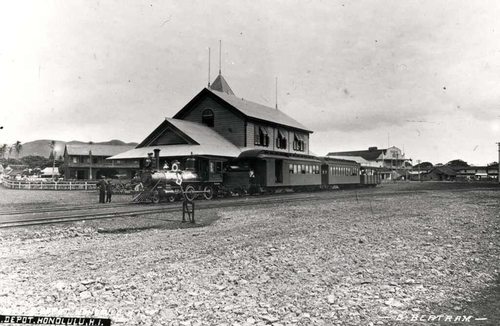
By 1895 the OR&L rail line reached Waiʻanae.  It then rounded Kaʻena Point to Mokuleʻia, eventually extending to Kahuku.  Another line was constructed through central O‘ahu to Wahiawa.

The Holt Ranch began selling off its land in the early-1900s.

In 1908, the Waiʻanae Sugar Company moved into Mākaha and by 1923, virtually all of lower Mākaha Valley was under sugar cane cultivation.  The plantation utilized large tracks of Lualualei, Waiʻanae and Mākaha Valley.

In the 1930s, Waiʻanae Plantation sold out to American Factors Ltd (Amfac.)  They started looking for a water source to increase production of the thirsty crop.  They tunneled for water; Glover Tunnel, named for the contractor, was 4,200-feet long and had a daily water capacity of 700,000-gallons. The water made available was mainly used for the irrigation of sugar.

For a half century, Mākaha was predominantly sugarcane fields.  However, by the middle of the century, the operations were no longer profitable and the plantation started to liquidate.

In 1946, the Dillinghams announced that they were discontinuing rail service, citing decline in tonnage, rising labor costs and tsunami damage in the system. On October 17, 1946 the stockholders of American Factors (owners of the Waiʻanae Sugar Company) voted to liquidate.

Chinn Ho’s Capital Investment Corporation bought the Mākaha lands and looked to resort development in the Valley.  He envisioned a travel destination that would be the next Kaʻānapali or even Waikiki, with golf courses, condominiums and hotels.

When the Mākaha big surf break was discovered and the eventual Mākaha International Surfing Championship was underway, tourists starting coming to Waiʻanae in the 1950s, as pioneer surfers made Mākaha Beach famous.

In 1969, the Mākaha Resort was built, including Mākaha Inn and Country Club, with an 18-hole course with tennis courts, restaurant and other golf facilities was opened for local and tourist use.

Over the decades, the resort has had several starts and stops, as well as a number of transfers of ownership.

© 2023 Hoʻokuleana LLC

Filed Under: Place Names Tagged With: Coffee, Oahu Railway and Land Company, Boki, Paki, Amfac, Waianae, Hawaii, Makaha, James Robinson, Liliha, Bernice Pauahi Bishop, Oahu, Sugar

December 19, 2021 by Peter T Young 4 Comments

O‘ahu Railway and Land Company (OR&L)

The story of Hawaii’s “Big Five” companies (Alexander & Baldwin, Amfac (American Factors), Castle & Cooke, C. Brewer & Co. and Theo. H Davies & Co.) dominates the state’s economic history.
 
Their common trait: they were founded in agriculture – sugar and pineapple.
 
Another Hawai‘i family and company, Dillingham, started business in the late-1800s; although not a “Big Five,” deserves some attention.
 
It’s beginning, in part, is traced to O‘ahu Railway and Land Company.  They didn’t necessarily produce agriculture, but they played a critical role in agricultural operations.
 
Benjamin Franklin (Frank) Dillingham formed OR&L (a narrow gauge rail,) whose economic being was founded on the belief that O‘ahu would soon host a major sugar industry.
 
In 1885, Dillingham embarked on a land development project west of Honolulu and, like his continental counterparts, realized that this venture would not succeed without improved transportation to the area.  He also figured that a railroad needed to carry freight, as well, in order to be profitable.
 
The drilling of the first artesian well on the Ewa Plain by James Campbell in 1879 presented Dillingham another opportunity.  He obtained 50-year leases beginning in 1887 from Campbell in Ewa.
 
In 1888, the legislature gave Dillingham an exclusive franchise “for construction and operation on the Island of O‘ahu a steam railroad … for the carriage of passengers and freight.”
 
Ultimately OR&L sublet land, partnered on several sugar operations and/or hauled cane from Ewa Plantation Company, Honolulu Sugar Company in ‘Aiea, O‘ahu Sugar in Waipahu, Waianae Sugar Company, Waialua Agriculture Company and Kahuku Plantation Company, as well as pineapples for Dole.
 
Likewise, OR&L hauled various stages in the pineapple harvesting/production, including the canning components, fresh pineapple to the cannery, ending up hauling the cased products to the docks.
 
By 1895 the rail line reached Waianae.  It then rounded Kaena Point to Mokuleia, eventually extending to Kahuku.  Another line was constructed through central O‘ahu to Wahiawa.
 
Passenger travel was an add-on opportunity that not only included train rides, they also operated a bus system.  However, the hauling for the agricultural ventures was the most lucrative.
 
They even included a “Kodak Camera Train” (associated with the Hula Show) for Sunday trips to Haleiwa for picture-taking.  During the war years, they served the military.
 
Just like the rail programs on the continent, the railroad owned and operated the Haleiwa Hotel and offered city folks a North Shore destination with beaches, boating, golf, tennis and hunting.
 
In addition, OR&L (using another of its “land” components,) got into land development.  It developed Hawai‘i’s first planned suburban development and held a contest, through the newspaper, to name this new city.
 
The winner selected was “Pearl City” (the public also named the main street, Lehua.)
 
The railway owned 2,200-acres in fee simple in the peninsula.  First they laid-out and constructed the improvements, then invited the public on a free ride to see the new residential community.
 
The marketing went so well; ultimately, lots were auctioned off to the highest bidder.
 
Multiple factors affected the ultimate demise of the rail operations: sugar/pineapple production fizzled in the islands; more and more people were getting automobiles for travel; a 1946 tsunami damaged tracks and the war’s end stopped military travel.
 
The last ride on OR&L’s train operations was on December 31, 1947, ending 58-years of steam locomotives hauling all kinds of people, freight and other around O‘ahu.
 
The Dillinghams were out of transportation, but were active in development, construction and dredging.
 
My father served as manager of the land department of OR&L (1952-1961.)  When OR&L and Hawaiian Dredging and Construction Company merged to form the Dillingham Corporation, he was manager and vice president at Dillingham until 1968.  As a kid, I remember going down to the old OR&L facility in Iwilei.
 
© 2021 Hoʻokuleana LLC
 

Filed Under: Economy, General, Prominent People Tagged With: Oahu Railway and Land Company, Dillingham, Images of Old Hawaii, Hawaii

September 30, 2021 by Peter T Young 5 Comments

Brothers Continue The Legacy

For much of the 1800s, sailing ships calling at Honolulu Harbor were serviced using double-hulled canoes or rowboats.
In 1900, three brothers, Jack, Herbert and William, formed Young Brothers and started doing small jobs around the Harbor.
Early in the century, there was only a narrow opening in the reef, so sailing ships anchored outside where they had room to maneuver. They then came ashore in their own boats or used launch services from the harbor.
Jack Young once reminisced about arriving in Honolulu in 1900 with a few cans of fruit, a large trunk and only twenty-five cents in cash – too little to pay to have his trunk brought ashore. So he rustled up a spare rowboat and rowed in his own gear.
In those days, there might be from five to twenty sailing ships off Sand Island. When a ship came in, the anchor line had to be run out to secure the ship; if the ship was coming to the dock, a line had to be carried to the pier.
In the early years of the company, Young Brothers used its first boat, Billy, to service the ships by carrying supplies and sailors to ships at anchor outside the harbor, as well as run lines for anchoring or docking vessels.
They also pulled boats off the reefs, conducted salvage operations and various other harbor-related activities (including harbor tours.)
The company grew over the years into an active interisland freight company.
When original brother Jack’s two sons became old enough, they joined the operation.
Jack Young Jr., joined the company as a regular employee in 1933. He soon captained various boats; in 1936 he became the permanent master of the Mamo (which in 1930 was the first all-steel tugboat in maritime history.)
Jack’s younger brother, Kenny Young, joined Young Brothers in 1946, after a stint in the Navy and graduation from Stanford.
He immediately became superintendent of Young Brothers’ freight department, a position he held until 1952. That same year, Young Brothers merged with Oahu Railway and Land Company (OR&L.)
Jack Jr. resigned from Young Brothers in 1952 (having disagreed with the merger and its resulting changes in management policies.)
However, Jack Jr. continued to broaden his maritime skills, earning a Master Maritime license and becoming a Harbor Pilot for the Territory of Hawai‘i, then Harbor Master for the State. (Jack Jr. passed away in 1994.)
Kenny remained with the company after the merger and served as manager of the land department of OR&L (1952-1961.)
When OR&L merged with Dillingham Corporation, he was manager and vice president at Dillingham until 1968.
He then moved to Kona and started his own real estate company. (Kenny passed away in 2004.)
Jack Young of the original Young Brothers is my grandfather; Jack Young Jr, my uncle; and Kenny Young, my father.
The Young family legacy at Young Brothers continued; for a while, my older brother, David Young, served as a Hawai‘i County Community Advisory Board Member for the Young Brothers Community Gift Giving program.
I am the youngest brother of the youngest brother of the youngest brother of Young Brothers.
© 2021 Hoʻokuleana LLC

Jack Edgar and Will Young 1903
Young_Brothers-first_boat-Billy
Young-Brothers-Captain_Jack_Young_(grandfather)_on_Makaala
Kenny Young
Kenny Young
Da_Braddahs
Young_Brothers-Fleet-1915
Young_Brothers_Boathouse-center_structure_with_open_house_for_boats_on_its_left-1910
Young Brothers Launch 'Sea Scout' in Honolulu Harbor-Lucas_Tower_in_background-PPWD-9-3-030-1905-400
Young Brothers Launch ‘Sea Scout’ in Honolulu Harbor-Lucas_Tower_in_background-PPWD-9-3-030-1905-400
Young_Brothers_Boathouse-1902
Young Brothers shark hunt
Kapena Jack Young Drawing
IMG_2905
IMG_7931

Filed Under: Prominent People, Economy, Sailing, Shipping & Shipwrecks Tagged With: Dillingham, Kenny Young, Images of Old Hawaii, Captain Jack, Hawaii, Jack Young, Young Brothers, Honolulu Harbor, Oahu Railway and Land Company

May 15, 2020 by Peter T Young 1 Comment

At The End Of The Line

Repeatedly evidenced in the early years of rail across the continent, railroads looked to expand their passenger business by operating hotels at the ends of the lines.

Once a railroad was being built to a new location, the land speculators would prepare for cashing in on their investment. A hotel would typically be in place by the time the railroad service began.

Prospective buyers needed to have a place to stay, so they could become enamored of the scenery and have time to be enticed into buying a piece of property.

Likewise, an ocean liner, while it served as a moving hotel, needed to make sure people had places to stay where the cruise ships stopped.

Simply look at the early history of trains and ships, the pattern is apparent. Several in Hawai‘i followed this example in the planning of their transportation systems.

Here’s a summary of a few hotels and attractions associated with Hawaiʻi’s transportation providers:

OR&L – Haleiwa Hotel
Dillingham’s Haleiwa Hotel was conceived as part of a larger concept. O‘ahu Railway & Land Company was built with the primary purpose of transporting sugar from western Honolulu and the North Shore to Honolulu Harbor.

Dillingham hoped to capitalize on his investment (and expand upon the diversity of users on his trains) by encouraging passenger travel as well; his new hotel was a means to this end. It thrived.

Matson – Moana Hotel
The Moana officially opened on March 11, 1901. Its first guests were a group of Shriners, who paid $1.50 per night for their rooms. Matson Navigation Company bought the property in 1932; they needed land-based accommodations equally lavish to house their cruisers to Hawaiʻi.

Over the course of Matson’s ownership of the Moana, it grew along with the popularity of Hawaiian tourism. Two floors were added in 1928 along with Italian Renaissance-styled concrete wings on each side of the hotel, creating its H shape seen today.

In 1952, a new hotel was built adjacent to the Moana called the Surfrider Hotel (on the east side of the Moana.) In the late-1960s (after the new Sheraton Surfrider Hotel was built on the west side of the Moana,) the old Surfrider building was made into a wing of the Moana Hotel.)

Matson – Royal Hawaiian Hotel
With the success of the early efforts by Matson Navigation Company to provide steamer travel to America’s wealthiest families en route to Hawaiʻi, Captain William Matson proposed the development of a hotel in Honolulu for his passengers.

This was in hope of profiting from what Matson believed could be the most lucrative endeavor his company could enter into. The Royal Hawaiian (Pink Palace of the Pacific) opened its doors to guests on February 1, 1927 with a black tie gala attended by over 1,200 guests. The hotel quickly became an icon of Hawaiʻi’s glory days.

Matson – Princess Kaʻiulani
After the war, tourism to Hawaiʻi expanded in the mid-1950s. To capitalize on this increasing boom in travel and trade, Matson constructed its third hotel, the Princess Kaʻiulani in 1955. Formerly the site of the Moana cottages, the land was cleared in 1953 to make way for a new high-rise.

At the time, the hotel’s Princess Wing was the tallest building in Hawaiʻi (11 stories, 131 feet above the ground). It was the largest hotel built in Hawai‘i, since The Royal Hawaiian in 1927.

In 1959 (the year Hawai‘i entered statehood and jet airline travel was initiated to the State,) Matson sold all of its hotel properties, including the four year-old Princess Kaʻiulani Hotel, to the Sheraton hotel chain.

Hotels weren’t the only end-of-the-line attraction.

Honolulu Rapid Transit and Land Company – Waikīkī Aquarium
The Waikīkī Aquarium opened on March 19, 1904; it is the third oldest aquarium in the United States. Its adjacent neighbor on Waikīkī Beach is the Natatorium War Memorial.

Then known as the Honolulu Aquarium, it was established as a commercial venture by the Honolulu Rapid Transit and Land Company, who wished to “show the world the riches of Hawaiʻi’s reefs”.

It was also a practical objective of using the Aquarium as a means of enticing passengers to ride to the end of the new trolley line in Kapi‘olani Park, where the Aquarium was located. (The trolley terminus was across Kalākaua Avenue from the Aquarium, near the current tennis courts.)

Follow Peter T Young on Facebook 

Follow Peter T Young on Google+ 

Follow Peter T Young on LinkedIn  

Follow Peter T Young on Blogger

© 2020 Hoʻokuleana LLC

OR&L Railroad 1891
OR&L Railway Depot
OR&L Train thunders past Mokuleia Field, Oahu,-(hawaii-gov-hawaiiaviation)-c1942-1943-400
OR&L-Iwilei-map
1930s Matson cruise ship departs Honolulu for San Francisco
Boat_Day
Boat Day Smithsonian-7058p
Matson-Royal_Hawaiian-Princess_Kaiulani-Moana-Surfride-Hotels_Ad-(eBay)-1958
Haleiwa Hotel
Archibald Cleghornʻs 50 years of membership in the British Club, taking place at Haleiwa Hotel
Bridge at Haleiwa Hotel
circa 1910, from The Advertiser's archives shows the old Hale'iwa Hotel
Haleiwa Hotel-(vintagehawaii)-1920s
Haleiwa Hotel-1935
Haleiwa_Hotel
Haleiwa_Hotel_1902
Haleiwa_Hotel-from rail
Haleiwa-Hotel
Moana Hotel-Apuakehau Stream-(Kanahele)-1915
Moana_Hotel_from_Pier-1924
Moana_Hotel-1929
Moana_Hotel-1940
Moana_Hotel-Aerial-1929
BVD 14-1-31-32 royal hawaiian hotel aerial August.22_750-150w-Kamehameha Schools Archives
BVD-14-1-31-41-Bertha Young residence and Royal Hawaiian hotel_150w-KamehamehaSchoolsArchives
Royal_Hawaiian-(hawaii-gov)-1928
Royal_Hawaiian_aerial-1930
Princess_Kaiulani_Hotel-1955
Princess_Kaiulani_Hotel-Moana-Surfrider-1958
Waikiki_Aquarium-1921 (UH)

Filed Under: Economy, General Tagged With: Oahu, Moana Hotel, Matson, Oahu Railway and Land Company, Haleiwa Hotel, Royal Hawaiian Hotel, Waikiki Aquarium, Hawaii

April 13, 2020 by Peter T Young Leave a Comment

Keawaʻula

Keawaʻula was believed to be part of the Kaʻena Point leina a ka ʻuhane (leaping places of souls into the spirit world;) at the northern part of the Waiʻanae coastline, it is at the western most point of Oʻahu.

Keawaʻula (red harbor or land) got the name from the squid that used to come into the area. When the squid would come into the ocean, from the shore it would appear as a reddish brown color. (ksbe)

Archaeologists turned up evidence of ancient agriculture in Keawaʻula when terraces indicating a former taro site were found at the bottom of the cliff. Several fishing shrines also existed here. (WaiʻanaeHS)

Poha Cave is said to have existed here. This cave had streams of fresh water running through it that were carried to Kaieiewaho Channel between Oʻahu and Kauaʻi. It is said that ancient Hawaiians out fishing would dive down at certain places with large calabashes and come up with fresh water from these streams. (WaiʻanaeHS)

Many years later, in 1859, when a house lot was being cleared in this area, a cave entrance covered by three large, flat stones was found. Freshwater was found inside, and people came from miles around to drink. This cave has since been named Keawaʻula Cave, but many believe it to be the fabled Poha Cave. (WaiʻanaeHS)

Missionary Levi Chamberlain during a trip along the Waiʻanae and Waialua coastline sometime prior to 1849 traveled northwest by canoe from the village of Keawaʻula to a “cove,” presumably a canoe landing, at the southeastern side of Kaʻena Point. (DLNR)

In “front of the little cove” was “a cave used by fishermen occasionally for a residence” which was about 30 feet high and had dimensions of 30 and 15 paces. The cave is described as being at “nearly the west point of the island” and south of the Waiʻanae and Waialua District boundary which dissects Kaʻena Point in an east-west direction. (DLNR)

He traveled from the cave “a short distance over a very rough path along the shore and came to the mokuna (boundary) of the large divisions of the island Wainai and Waiarua.” This may be the cave called “Ke Ana Moe of Kaʻena” in 1954 which was said to be used by travelers from Mākua to Waialua. This cave may have been obscured by construction of the railway bed. (DLNR)

Keawaʻula was known for its aku and ahi fishing grounds. The coastal fisheries were also noted as particularly productive when submerged, woven basket traps (hinaʻi) were used to catch kala and hinalea. (DLNR)

When describing basket traps in general, Kamakau notes a particular pattern and size of basket trap that was made for kala fish and also states it to be “a land abounding in kala fishs”. (DLNR)

Most of the government lands and private lands at Keawaʻula were leased for ranching during the second half of the 1800s and first half of the 1900s. A major portion of Keawaʻula became government land after Laʻamaikahiki relinquished “½” of the ahupuaʻa to the King during the 1848 Māhele and the King then designated it government land. (DLNR)

When the privately-owned lands along the coast were acquired by the State of Hawaiʻi in the 1970s to create Kaʻena Point State Park, all were owned by ranching interests or by families with ranching interests in the area. The Keawaʻula section of the point was owned by Elizabeth Marks who inherited McCandless Ranch.

Keawaʻula is now generally referred to as Yokohama Bay. Several stories suggest the later name. One story suggests this was a favorite fishing spot for Japanese living on Oʻahu; they gave it the nickname Yokohama after the famous fishing village in Japan. (ksbe)

When OR&L extended its rail line around Kaʻena Point, boats carried Japanese laborers, equipment and supplies to the site and freight back; on October 14, 1897, the place where the first Japanese laborers landed for this job is known to this day as “Yokohama Beach.” (ascehawaii)

Another story is that there was a Japanese man who ran the train station there. Because he was Japanese, people nicknamed him “Yokohama” – and thus the place carried it. (WaiʻanaeHS)

The Bay is at the beginning of the Kaʻena Natural Area Reserve. There is a lifeguard and restroom (only at the reserve entrance;) no facilities exist beyond that point. Under the Natural Area Reserve system, off-road driving is prohibited in the area to protect native plant and animal habitats.

Follow Peter T Young on Facebook 

Follow Peter T Young on Google+ 

Follow Peter T Young on LinkedIn  

Follow Peter T Young on Blogger

© 2020 Hoʻokuleana LLC

Hawaii
Keawaula
Keawaula_Bay
Keawaula_Yokohama
KeawaulaYokohama
Keawaula-Yokohama
Keawaula Bay Sign
Keawaula-Park_Sign
Waianae District

Filed Under: Economy, Place Names Tagged With: Waianae, Keawaula, Kaena, Yokohama, Hawaii, Oahu, Oahu Railway and Land Company

  • « Previous Page
  • 1
  • 2
  • 3
  • 4
  • 5
  • Next Page »

Images of Old Hawaiʻi

People, places, and events in Hawaiʻi’s past come alive through text and media in “Images of Old Hawaiʻi.” These posts are informal historic summaries presented for personal, non-commercial, and educational purposes.

Info@Hookuleana.com

Connect with Us

  • Email
  • Facebook
  • LinkedIn
  • Twitter
  • YouTube

Recent Posts

  • Manokalanipō
  • Invasion of Waikiki
  • Waihou Spring
  • Tax Maps
  • Matsumoto Shave Ice
  • Kona Coast
  • Jeopardy! Reminds Us of #SharingTheSpiritOfAmerica

Categories

  • General
  • Ali'i / Chiefs / Governance
  • Buildings
  • Missionaries / Churches / Religious Buildings
  • Hawaiian Traditions
  • Military
  • Place Names
  • Prominent People
  • Schools
  • Sailing, Shipping & Shipwrecks
  • Economy
  • Voyage of the Thaddeus
  • Mayflower Summaries
  • American Revolution

Tags

Albatross Al Capone Ane Keohokalole Archibald Campbell Bernice Pauahi Bishop Charles Reed Bishop Downtown Honolulu Eruption Founder's Day George Patton Great Wall of Kuakini Green Sea Turtle Hawaii Hawaii Island Hermes Hilo Holoikauaua Honolulu Isaac Davis James Robinson Kamae Kamaeokalani Kameeiamoku Kamehameha Schools Lalani Village Lava Flow Lelia Byrd Liberty Ship Liliuokalani Mao Math Mauna Loa Midway Monk Seal Northwestern Hawaiian Islands Oahu Papahanaumokuakea Marine National Monument Pearl Pualani Mossman Quartette Thomas Jaggar Volcano Waikiki Wake Wisdom

Hoʻokuleana LLC

Hoʻokuleana LLC is a Planning and Consulting firm assisting property owners with Land Use Planning efforts, including Environmental Review, Entitlement Process, Permitting, Community Outreach, etc. We are uniquely positioned to assist you in a variety of needs.

Info@Hookuleana.com

Copyright © 2012-2024 Peter T Young, Hoʻokuleana LLC

Loading Comments...