Images of Old Hawaiʻi

  • Home
  • About
  • Categories
    • Ali’i / Chiefs / Governance
    • American Protestant Mission
    • Buildings
    • Collections
    • Economy
    • Missionaries / Churches / Religious Buildings
    • General
    • Hawaiian Traditions
    • Other Summaries
    • Mayflower Summaries
    • Mayflower Full Summaries
    • Military
    • Place Names
    • Prominent People
    • Schools
    • Sailing, Shipping & Shipwrecks
    • Voyage of the Thaddeus
  • Collections
  • Contact
  • Follow

November 3, 2019 by Peter T Young Leave a Comment

Nu‘alolo Kai

Located on the northwest coast of Kauai, the Nā Pali contains some of the Pacific Islands most spectacular wilderness area.

There was a string of former Hawaiian fishing villages in the seven main valleys on the Nā Pali Coast of Kauai. These remote communities relied on harvesting the fish from the sea, and growing taro in the fertile soil of the valley floors.

One of these is Nu‘alolo Kai, it’s located in a protected inlet along the Nā Pali Coast. You can’t get there by land, you must arrive by boat.

And, you need a permit from DLNR to do so.

“The mountains along the shore, for eight or ten miles, are very bold, some rising abruptly from the ocean, exhibiting the obvious effects of volcanic fires; some, a little back, appear like towering pyramids”. (Hiram Bingham, 1822)

“Here, about mid-way of what the natives call the Parre, we landed, where is an acre or two of sterile ground, bounded on one side by the ocean, and environed on the other by a stupendous rock, nearly perpendicular …”

“… forming at its base a semicircular curve, which meets the ocean at each end. In the middle of the curve, a stupendous rock rises to the height, I should say, of about 1500 feet.” (Bingham)

“Like Kalalau they had a trail from the table land above over the top of Kamaile and zigzagging down through the cliffs some 3000 feet to the valley below but even this trail was difficult. At one place you have to jump a crevice only three feet wide …”

“… but it goes down straight like a chimney and if you slipped you would only fall 800 feet to the rocks below. They call it the Puhi.” (Knudsen, late-19th-century)

“Here, the natives sometimes exhibit their fire works (ʻŌahi) in the night (from “the fire Parre”,) as they did a few nights since, when the kings lodged there.”

“Along a winding, difficult ascent, which commences by a rude ladder hanging over the sea, they climb to the very summit, and throw off firebrands, or torches, ingeniously constructed, which sail off a great distance, and fall in the ocean below.” (Bingham)

“The two most famous ʻōahi places on Kauai were Kamaile peak, rising 2500 feet over Nuuololo [Nu‘alolo] landing on the Na Pali Coast, and the high cliffs that tower over the wet caves at Haena.” (Knudsen)

“Here in Nuʻalolo Kai the fishermen built and kept their canoes and the beach must have been lined with them for the landing is most always safe as the channel is narrow and a big reef to the north protecting it.” (Knudsen)

Bishop Museum archaeological investigations, starting in 1958, noted buried structure floors and artifacts, including fishhooks and coral files, were found as deep as 6 feet below the surface.

Radiocarbon dates later showed that people first began to live at the site between AD 1300 and 1500. The presence of historic artifacts, such as glass beads and metal jewelry, told archaeologists that the site was still inhabited even after Europeans arrived in the Hawaiian Islands.

About 100 people, mostly commoners, lived in Nuʻalolo Kai. They farmed terraced taro fields, collected shellfish, and gathered coral from the fringing reef to shape their bone and shell fishhooks. Reef fish included rudderfish, unicorn tang and parrotfish.

Raw and cooked urchins were popular, and urchin gonads were used as a condiment with fish, poi (cooked taro), and sweet potato. (National Geographic)

“Their method of taking the fish from the sea is remarkable. Diving down, they place a vegetable poison among the stones at the bottom, which being greedily eaten by the fish, immediately produces on them an intoxicating effect.”

“The natives then dive or swim after them, and catch them in their hands, or, sitting in canoes, or standing near the shore, take them easily in scoop nets.” (Bingham)

Ceremonies were celebrated with ʻawa, a ritual drink also known as kava, while hula dancers chanted and pulsed to the beat of the drums. Young men hurled firebrands from the cliff of Kamaile.

Even King Kamehameha II made a trip to the island to witness the ceremonies. It’s still unclear why the site was abandoned, but Hawaiians permanently left Nuʻalolo Kai in 1919 for more populated parts of the island, including Hanalei and Waimea. (National Geographic)

Follow Peter T Young on Facebook 

Follow Peter T Young on Google+ 

Follow Peter T Young on LinkedIn  

Follow Peter T Young on Blogger

© 2019 Hoʻokuleana LLC

Na-Pali-Coast-Nualolo to Haena
Photo taken from the Pali above the western end of Nu’alolo Kai, circa 1900-(Carpenter)
Nualolo_Kai-Bishop Museum Excavations within K-2, Site 196-(Carpenter)-1958
Nualolo_Kai-Bishop Museum Excavations within K-3 & K-4, Site 196-(Carpenter)-1958
Nualolo_Kai-Bishop Museum Excavations within K-3, Site 196-(Carpenter)-1958
Nualolo_Kai-Bishop_Museum-archaeological_investigation-1958-k3-ii-008_ppt
Nualolo_Kai-Bishop_Museum-archaeological_investigation-1958-k3-i-012_ppt
Nualolo_Kai-Bishop_Museum-archaeological_investigation-1958-k3-i-013_ppt
Nualolo_Kai-Bishop_Museum-archaeological_investigation-1958-k3-iii-009_ppt
Kahua o Nu'alolo Kai-(Wichman)
Na_Pali_Coast_Ohana-Native Hawaiian plant restoration nursery-(Wichman)
Nu'alolo Kai cliff house platforms-(Wichman)
Nualolo Kai-(Carpenter)
Nualolo_Kai-(Wichman)
Nualolo_Kai_restored hālau wa‘a (canoe shed)
Nualolo_Kai-Bishop_Museum-archaeological_investigation-View of the inlet at Nu'alolo Kai-1958
Nualolo_Kai-Cliff_house_Sites-(Carpenter-BishopMuseum)-1930
Nualolo_Kai-fishing_village
'Oahi'-Fireworks from 'the fire Parre'-(Carpenter)
Nualolo_Kai-Archaeological_Maps-(Carpenter)
Nualolo_Kai_Archaeological_Maps-(Carpenter)
Nualolo_Kai-Map
PHOTOG~1

Filed Under: Place Names Tagged With: Hawaii, Kauai, Na Pali, Nualolo Kai, Kalalau, Oahi

August 21, 2015 by Peter T Young 2 Comments

Until Death Should Us Part

Within the seconds, the minutes, and the hours,
Within your loneliness and sorrow,
Within the flowers, the leaves and everything,
Within you and without, I am with you.

He stood before the officer of the government and said, “I first ask whether my wife will be allowed to go with me, the one I swore before Almighty God to care for, to become one blood with me, from whom only death could part me?”

Denied, he replied, “the cord of my love for her is to be cut, and I am commanded to break my sacred promise before God and live alone in a strange land”.

“The consecrated law of marriage has come to us, and we swore by the holy book to live together in the time of food and of famine, in sickness and in health … until death should part us, and now, the power of the government wants to break the law of man and of God and make the oath before Almighty God as nothing.” (Koʻolau)

He was born in 1862; his name, Kaluaikoʻolau, may be translated as ‘the grave at Koʻolau,’ a commemorative name and, as fate would have it, prophetic. (Frazier) He was a cowboy from Kekaha, Kauai.

He was reared with care and vigilance, and his growth was unrestricted. And when he reached the age he was entered by his parents, in 1868, in the school of Father George Rowell at Waimea, Kauai.

In a very little while at the school he displayed understanding and enthusiasm for his lessons, and his energy and alertness was unfailing. He also was willing and active in the tasks given him by the parents, showing his love and attention to their voices.

In these days of his growth there was planted in his heart the reverence for the word of God, and the beauty of the sacred lessons was wound in his conscience. Therefore, with the growth of Koʻolau’s body, these spiritual qualities grew also.

Thus he sought the learning of the school until he was grown and he was physically ready for work, between sixteen and seventeen years of age, and he spoke to his parents of setting aside school and going to work, and his request was granted by his parents with serenity.

He became the foreman of the cowboys, under Mr. Francis Gay (Palani Ke.) He was also placed in this position over the length and the breadth of Mr. Valdemar Knudsen’s (Kanuka) lands at Kekaha. He divided his duties as Head of the Cowboys between his two employers.

In 1881, at the age of 19, he married Piʻilani (age 17.) A year later, they had a son, Kaleimanu.

In 1889, Koʻolau noticed a little rash on his cheeks – he thought it was because of his work out in the sun. It would later disappear and reappear.

“In a couple of years the disease developed quite noticeably, and in 1891 and 1892 when the gathering of the lepers started, he was in a bad state, and Mr Stolz, the deputy sheriff, told him to go to Doctor Campbell and be examined.” (The Garden Island, December 19, 1916)

Koʻolau and his young son Kaleimanu contracted leprosy; the Hawaiian government’s way of coping with the problem was to attempt to strictly segregate leprosy patients from the rest of the world at Kalawao (Kalaupapa,) on the Island of Molokai.

In the early years of the settlement, those who contracted leprosy were allowed to be accompanied by helpers, or kokua, usually a family member, but this practice caused problems. In 1893, Koʻolau, agreed at first to go to Molokai if Piʻilani, his wife, could accompany him.

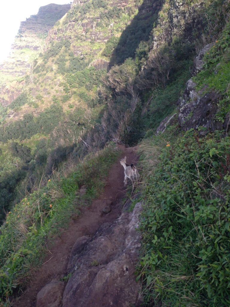
The authorities denied this. Koʻolau refused to be parted from his wife. Vowing he would never be taken alive, the husband with wife and young son took refuge in the isolated Kalalau Valley, descending into it by an ancient and most difficult trail.

Government forces pursued them. Koʻolau shot a policeman who had been pursuing them (Louis Stolz (known familiarly by the name of Lui), the Deputy High Sheriff of Waimea.)

“On June 30th the districts of Waimea and Hanalei, which included the village of Kalalau, were placed under martial law and an armed force of police and military, under the command of Deputy Marshal Larsen, was sent to Kalalau to effect the capture of the desperado.”

“It was the intention to secure the murderer alive, if possible, and establish the majesty of the law without further bloodshed. … but Koʻolau sent defiance and a statement that he would never be taken alive.” (Polynesian, July 13, 1893)

The Provisional Government determined to send an army of 35-men, under Capt W Larsen to Kalalau to carry out the orders of the Government; ultimately, 15-soldiers landed and set up ‘Camp Dole.’ All lepers were directed to be taken prisoner within 24-hours. If the lepers failed to obey after the time given them they were to be taken dead or alive. (Frazier)

Hidden in the valley, “We listened quietly to the noise and understood that the soldiers were climbing up to our place where we sat. It was not far, but we could not be seen or see because of the vegetation. Then we were again startled by the firing of guns and the bullets began to strike … but no one harmed us.” (Piʻilani)

Koʻolau shot back, killing three soldiers, P Johnson, JMB McCabe and Hirschberg (Hursberg.)

The firing continued without rest for four full days.

On Friday morning, July 13, the steamship Iwalani arrived from the battle site at Kalalau. The leper Koolau and his wife and son had not been found. Perhaps another search will be made for his hiding place, or perhaps he fell from the cliff. His hiding place had been blanketed by gunfire. There was no sign of refuge, only a very small flat place at the edge of the cliff, protected in front by steep drops and ʻōhia trees. (Frazier)

They fled. “After this we began to wander, never staying anywhere more than one, two, or three days in one place, when we would leave and move on. … During this time of living in loneliness and inaction, for a long time afterwards, my husband would not allow us to show ourselves.”

“It was three years and five or more months of wandering life in the wild valleys and rows of steep cliffs, in the midst of an awesome loneliness. We set aside love of parents and family, cast away our fears and sighs, and I sacrificed my life for my husband and child, so beloved to me.” (Piʻilani)

“During this time of living as a threesome, we were well and we had sufficient to eat and drink.” Then, tragedy struck; “our beloved child began to show the spread of the disease upon his body, and he became very weak in his limbs.”

“(O)ne day, he gestured to me and when I went to his side, he put his arms around my neck and rubbed his cheek against mine, and I saw that his lashes were wet with tears, and he whispered; ‘Where is Papa? I am going to sleep.’”

“We attempted to speak with him, calling him, but his ears were done hearing, his eyes gently closed, his last breath flew away, and he was asleep in the Lord, his Saviour in the beyond.” (Piʻilani)

Then it was Koʻolau’s time. “My cheeks were often wet with tears, seeing the body and the features of my husband quietly ebbing away, without being able to help and save him although I tried, with every means available to me.”

“When the sun began to spread its warming rays over the land that morning, and the palis and ridges of that beloved valley were spread out, Koʻolau slept quietly in death.” (Piʻilani)

“I wandered alone in the cloaking darkness, with the rustling murmurs of the little stones of the stream and the sweet murmuring land shells of the ti-plants, and when the dawn came and the clouds of night crept softly behind the high peaks and the light of the sun flashed forth, I had arrived at a place close to the kamaʻāinas’ homes.” She hid for nearly a month before revealing herself.

In 1906 in Honolulu, Kahikina Kelekona (John GM Sheldon) published a book in the Hawaiian language (later translated by Frances N Frazier) to be preserved in ink and disseminated to the many people of the true story of Kaluaikoʻolau, the one boasted of as “The Fierce Brave One of the Kalalau Cliffs who Glides along the Peak of Kamaile whence the Fire was Flung.” It was the basis of this summary.

Follow Peter T Young on Facebook 

Follow Peter T Young on Google+ 

Follow Peter T Young on LinkedIn  

Follow Peter T Young on Blogger

© 2015 Hoʻokuleana LLC

Kaluaikoolau and Family-HSA-HHS
Hawaiian_Provisional_Government_Soldiers_at_Kalalau_Valley,_Kauai
Home of Kaluaikoolau at Mana, Kauai-HSA-HHS
Kaluaikoolau seated on rock, his wife Piilani and son Kaleimanu in pool of Makemake Falls, Kalalau-HSA-HHS
'Lepers' captured by police and National Guard in Kalalau Valley, Kauai-HSA-HHS
‘Lepers’ captured by police and National Guard in Kalalau Valley, Kauai-HSA-HHS
National Guardsmen guarding trail in Kalalau Valley, Kauai-HSA-HHS
Hawaiian_Provisional_Government_Soldiers_camped_in_Kalalau_Valley,_Kauai
Burning of Koolau's house in Kalalau Valley, Kauai-HSA-HHS
Burning of Koolau’s house in Kalalau Valley, Kauai-HSA-HHS
Firing Squad Company F of the National Guard of Hawaii, Kalalau Valley, Kauai. At grave of three members killed during hunt for Kaluaikoolau-HSA-HHS
Camp of National Guardsmen in hunt for Koolau and others, Kalalau Valley, Kauai-HSA-HHS


Filed Under: Prominent People Tagged With: Kalaupapa, Hansen's Disease, Kalawao, Hawaii, Kauai, Kalalau

November 23, 2014 by Peter T Young Leave a Comment

Nāpali

Kaua‘i nui moku lehua pane‘e lua i ke kai
Great Kaua‘i of the lehua groves which seem to move two-by-two to the shore (Maly)

Kauaʻi is the oldest of the eight main Hawaiian islands, and the island consists of one main extinct shield volcano estimated to be about 5-million years old, as well as numerous younger lava flows (between 3.65-million years to 500,000-years old). The island is characterized by severe weathering.  (DLNR)

Historically, it was divided into several districts and political units, which in ancient times were subject to various chiefs—sometimes independently, and at other times, in unity with the other districts. These early moku o loko, or districts included Nāpali, Haleleʻa, Koʻolau, Puna and Kona (Buke Mahele, 1848; May.)

Although Nāpali, on the northwestern portion of the Island, is remote and difficult to access, many may not realize that for about a thousand years, Hawaiians lived along the Nāpali coast, farming, fishing and worshiping.  There are irrigation ditches, terraced fields, house platforms, heiau (temples and shrines) and graves.”

“The design of these places took into account the natural topography and environment, and as a result these ancient sites often blend into the landscape. … The aspects of the land that Hawaiians sought for their sites – level ground, ocean access and availability of fresh water (hold true today.)”  (DLNR)

The Nāpali valleys were intensively cultivated and the larger valleys such as Kalalau were densely inhabited. Taro was raised in terraced loʻi along the streams and other crops such as bananas, sugar cane and sweet potato were grown above the loʻi.

Other plants including wauke and mamaki for bark cloth and kukui nuts for food and oil for light were grown in the gulches.  There were overland trails connecting many of these valleys and these areas were also accessed via canoe.  (Handy; Maly)

Land use records from 1856-1857 show that lands in Kalalau, Pohakuao and Honopu valleys were being used for the cultivation of kalo, olona and kula. In the late-1800s Hanakoa and Hanakāpīʻai were also used for coffee cultivation. Kalalau was abandoned in 1919 and then used for cattle grazing in the 1920 for a limited time.  (DLNR)

“The mountains along the shore, for eight or ten miles, are very bold, some rising abruptly from the ocean, exhibiting the obvious effects of volcanic fires; some, a little back, appear like towering pyramids”.  (Hiram Bingham, 1822)

“There is a tract of country on the west coast of the island, through which no road is practicable.”  (Bowser, 1880; Maly) “For twenty miles along the northwestern coast of Kauaʻi there extends a series of ridges, none less than 800-feet high, and many nearly 1,500-feet, terminating in a bluff that is unrivalled in majesty. Except for a very narrow, dangerous foot-path, with yawning abysses on each side, this bluff is impassable.”    (The Tourist’s Guide, Whitney, 1895)

The trail was originally built around 1860 (portions were rebuilt in the 1930s) to foster transportation and commerce for the residents living in the remote valleys.

Local labor and dynamite were used to construct a trail wide enough to accommodate pack animals loaded with oranges, taro and coffee being grown in the valleys. Stone paving and retaining walls from that era still exist along the trail.

It traverses 5-valleys over 11-miles, from Hāʻena State Park to Kalalau Beach, where it is blocked by sheer, fluted cliffs (pali;) it drops to sea level at the beaches of Hanakāpīʻai and Kalalau. The first 2 miles of the trail, from Hāʻena State Park to Hanakāpīʻai Beach, make a popular day hike.  (DLNR)

“Innumerable streams, forming wonderful cascades as they leap hundreds of feet in their tempestuous decent, pour over this bluff in the rainy season, and become mist before they reach the ocean. Beyond the raging surge, unbroken by any protecting reef, dashes against the precipitous walls of rock.”

“(T)he tourist can see all that has been described from Wednesday morning until Saturday evening, when the steamer returns to Honolulu.  If, however, he has time and the inclination to remain another week, there are many points of interest that can tempt him to make a longer stay, sights and scenes that can never be forgotten…”  (The Tourist’s Guide, Whitney, 1895)

“Here, about mid-way of what the natives call the Parre (Pali,) we landed, where is an acre or two of sterile ground, bounded on one side by the ocean, and environed on the other by a stupendous rock, nearly perpendicular, forming at its base a semicircular curve, which meets the ocean at each end. In the middle of the curve, a stupendous rock rises to the height, I should say, of about 1,500-feet.” (Bingham)

“Like Kalalau they had a trail from the table land above over the top of Kamaile and zigzagging down through the cliffs some 3,000-feet to the valley below but even this trail was difficult. At one place you have to jump a crevice only three feet wide but it goes down straight like a chimney and if you slipped you would only fall 800 feet to the rocks below. They call it the Puhi.”  (Knudsen, late-19th-century)

“(At) Nuʻalolo Kai the fishermen built and kept their canoes and the beach must have been lined with them for the landing is most always safe as the channel is narrow and a big reef to the north protecting it.” (Knudsen)

“During the Māhele, the King granted lands to the Kingdom (Government), the revenue of which was to support government functions. In the Nāpali District, the ahupuaʻa of Kalalau, Pohakuao, Honopu, Hanakāpīʻai and one-half of Hanakoa were granted to the Government Land inventory.”

“Portions of the lands that fell into the government inventory were subsequently sold as Royal Patent Grants to individuals who applied for them. The grantees were generally long-time kamaʻāina residents of the lands they sought… Thirty grants were sold in the Nāpali District to twenty-seven applicants; the lands being situated in Kalalau and Honopu.” (Hawaiian Government, 1887; Maly)

The upper region of the area was put into Territorial Forest Reserve (Nā Pali – Kona Forest Reserve) for protection in 1907. Even before that time, the concern for native forest prompted cattle eradication activities in this area during 1882 and 1890.

In response to public demand and to promote improved public safety, camping permits for Nāpali Coast are issued for Kalalau only, the preferred destination at the end of the 11-mile Kalalau Trail (these permits also allow camping at Hanakoa, which is located a little beyond the halfway point of the trail, roughly 6 miles in from the trailhead.)

For most backpackers in good condition, hiking the 11-miles will take a full day. Those without camping permits for Kalalau Valley are therefore prohibited from attempting the entire 22-mile round trip hike in a day. For those with camping permits, get an early start.

Other than hiking the coast, the only way to legally access shore areas in Na Pali Coast State Wilderness Park is by boat.  Personal or rented kayaks and guided kayak tours may land at two permitted areas (Kalalau and Miloliʻi,) and motorized raft tours take passengers on shore at Nuʻalolo Kai.

Landing of kayaks is permitted at Kalalau Beach (May 15 through September 7 only) with valid camping permits. Landings of kayaks and other watercraft at Miloliʻi Beach are permitted for camping (with valid permits, May 15 through September 7.)

Day use landings are allowed at Miloliʻi during the summer (May 15 through Labor Day) without a permit. No other boat landings are permitted within the park. Kayak landings are prohibited at all other beaches in the park, including Hanakāpīʻai, Honopu and Nuʻalolo Kai. (This only summarizes some of DLNR’s rules; review and know the rules before you go.)

The image shows a portion of the Nāpali coast.   In addition, I have added other images in a folder of like name in the Photos section on my Facebook and Google+ pages.

Follow Peter T Young on Facebook  

Follow Peter T Young on Google+    

Follow Peter T Young on LinkedIn   

© 2014 Hoʻokuleana LLC

Filed Under: Place Names Tagged With: Hawaii, Kauai, Na Pali, Nualolo Kai, Milolii, Honopu, Napali, Kalalau

Images of Old Hawaiʻi

People, places, and events in Hawaiʻi’s past come alive through text and media in “Images of Old Hawaiʻi.” These posts are informal historic summaries presented for personal, non-commercial, and educational purposes.

Info@Hookuleana.com

Connect with Us

  • Email
  • Facebook
  • LinkedIn
  • Twitter
  • YouTube

Recent Posts

  • Currency Stamped with “HAWAII” during WWII
  • Evolution of the Volcano House
  • Gay Queen Of The Waves
  • Royal Residences
  • Nāhiku Rubber Company
  • For the Birds
  • James Otis

Categories

  • General
  • Ali'i / Chiefs / Governance
  • Buildings
  • Missionaries / Churches / Religious Buildings
  • Hawaiian Traditions
  • Military
  • Place Names
  • Prominent People
  • Schools
  • Sailing, Shipping & Shipwrecks
  • Economy
  • Voyage of the Thaddeus
  • Mayflower Summaries
  • American Revolution

Tags

Albatross Aloha Camp Battery Opaeula Bible Study Bison Campbell Building Church College of Hawaii Common Course and Condition Communications Construction Hale O Lono Harriet Tubman Hawaiian Culture Heiau Isaac Allerton Issei Jack London State Historical Park James Morrison Joseph Dwight Strong Kamanawa Kamehameha IV Kanakea Pond Kauai Keaiwa Heiau Land Policy Lunalilo Home Mao Milolii Missionaries Miss Veedol Old Courthouse Orange Pearl Harbor Yacht Club Pennsylvania Resolution Revolutionary War Samuel Damon Thirty Meter Telescope Train Robbery Vancouver Island Veterans Memorial Freeway Virginai Waiohinu William White WWII

Hoʻokuleana LLC

Hoʻokuleana LLC is a Planning and Consulting firm assisting property owners with Land Use Planning efforts, including Environmental Review, Entitlement Process, Permitting, Community Outreach, etc. We are uniquely positioned to assist you in a variety of needs.

Info@Hookuleana.com

Copyright © 2012-2021 Peter T Young, Hoʻokuleana LLC


Loading Comments...